Possible weak development east of FL this week? (Is 92L)
Moderator: S2k Moderators
Forum rules

The posts in this forum are NOT official forecasts and should not be used as such. They are just the opinion of the poster and may or may not be backed by sound meteorological data. They are NOT endorsed by any professional institution or STORM2K. For official information, please refer to products from the National Hurricane Center and National Weather Service.

Possible weak development east of FL this week? (Is 92L)
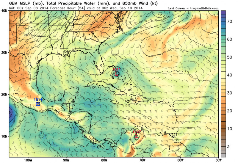
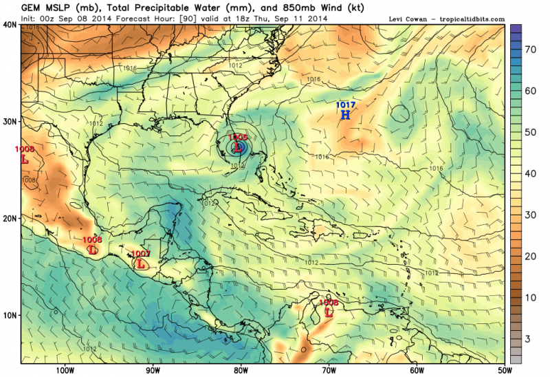
The ECMWF has been showing that the ULL near the SE Bahamas will slowly die out as it slowly moves westward and in its place an H85 vorticity could come out of it near the northern Bahamas, it shows it to meander around just east of SE & east Cent FL through the early weekend. Unlike the similar event that happened with a system this past week the vorticity will stay offshore so it may have higher chances for development if UL winds cooperate. Currently it only has support from the CMC/GEM which is very bullish, but this is an area that the Euro has done really well.
0 likes
-
tropicwatch

- Category 5

- Posts: 3205
- Age: 60
- Joined: Sat Jun 02, 2007 10:01 am
- Location: Panama City Florida
- Contact:
Stay tuned for the next episode of, is it a homegrown:)
0 likes
Tropicwatch
Agnes 72', Eloise 75, Elena 85', Kate 85', Charley 86', Florence 88', Beryl 94', Dean 95', Erin 95', Opal 95', Earl 98', Georges 98', Ivan 2004', Arlene 2005', Dennis 2005', Ida 2009' Debby 2012' Irma 2017' Michael 2018'
Agnes 72', Eloise 75, Elena 85', Kate 85', Charley 86', Florence 88', Beryl 94', Dean 95', Erin 95', Opal 95', Earl 98', Georges 98', Ivan 2004', Arlene 2005', Dennis 2005', Ida 2009' Debby 2012' Irma 2017' Michael 2018'
-
CYCLONE MIKE
- Category 5
- Posts: 2183
- Joined: Tue Aug 31, 2004 6:04 pm
- Location: Gonzales, LA
Re: Possible weak development east of FL this week?
Sure, just like we were supposed to have 2 storms in the gulf this past weekend and this week. 
0 likes
-
tropicwatch
- Category 5
- Posts: 3205
- Age: 60
- Joined: Sat Jun 02, 2007 10:01 am
- Location: Panama City Florida
- Contact:
I've seen quick developers before but I don't see it happening this year. 
0 likes
Tropicwatch
Agnes 72', Eloise 75, Elena 85', Kate 85', Charley 86', Florence 88', Beryl 94', Dean 95', Erin 95', Opal 95', Earl 98', Georges 98', Ivan 2004', Arlene 2005', Dennis 2005', Ida 2009' Debby 2012' Irma 2017' Michael 2018'
Agnes 72', Eloise 75, Elena 85', Kate 85', Charley 86', Florence 88', Beryl 94', Dean 95', Erin 95', Opal 95', Earl 98', Georges 98', Ivan 2004', Arlene 2005', Dennis 2005', Ida 2009' Debby 2012' Irma 2017' Michael 2018'
Re: Possible weak development east of FL this week?
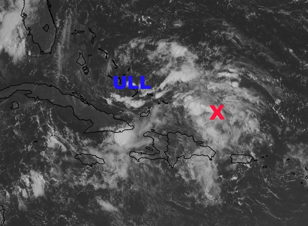
I am watching the area ESE from the ULL where I marked the X, there is a nice vorticity noticed on visible satellite this morning and some LL convergence going on there as well.
0 likes
-
northjaxpro

- S2K Supporter

- Posts: 8900
- Joined: Mon Sep 27, 2010 11:21 am
- Location: Jacksonville, FL
Don't underestimate these models. There has been a lot of activity in the Bahamas and off the East Coast of Florida this season. Also, you don't have to have a full fledge developed tropical cyclone to cause you problems. The elongated Low pressure/surface trough which has plagued my area since Friday, is causing flooding in parts of North Florida and South GA at this time. As of now, I have measured just under 6 inches at my locale since Friday.
So, I am paying attention to what the models think may happen off the Florida East Coast again this week. It definitely needs to have a watchful eye imo.
So, I am paying attention to what the models think may happen off the Florida East Coast again this week. It definitely needs to have a watchful eye imo.
0 likes
NEVER, EVER SAY NEVER in the tropics and weather in general, and most importantly, with life itself!!
________________________________________________________________________________________
Fay 2008 Beryl 2012 Debby 2012 Colin 2016 Hermine 2016 Julia 2016 Matthew 2016 Irma 2017 Dorian 2019
________________________________________________________________________________________
Fay 2008 Beryl 2012 Debby 2012 Colin 2016 Hermine 2016 Julia 2016 Matthew 2016 Irma 2017 Dorian 2019
Re:
northjaxpro wrote:Don't underestimate these models. There has been a lot of activity in the Bahamas and off the East Coast of Florida this season. Also, you don't have to have a full fledge developed tropical cyclone to cause you problems. The elongated Low pressure/surface trough which has plagued my area since Friday, is causing flooding in parts of North Florida and South GA at this time. As of now, I have measured just under 6 inches at my locale since Friday.
So, I am paying attention to what the models think may happen off the Florida East Coast again this week. It definitely needs to have a watchful eye imo.
I totally agree, had the area of low pressure in your area would had stayed offshore we probably would had been dealing with a TS offshore the Carolinas this morning, IMO.
0 likes
-
northjaxpro
- S2K Supporter
- Posts: 8900
- Joined: Mon Sep 27, 2010 11:21 am
- Location: Jacksonville, FL
Another thing also NDG is that the steering flow was very weak with this recent Low this past weekend, and that caused this Low/trough to move through very slowly. This was why we had so much rain in my area and other parts of the North FL and Southeast GA region this weekend.
0 likes
NEVER, EVER SAY NEVER in the tropics and weather in general, and most importantly, with life itself!!
________________________________________________________________________________________
Fay 2008 Beryl 2012 Debby 2012 Colin 2016 Hermine 2016 Julia 2016 Matthew 2016 Irma 2017 Dorian 2019
________________________________________________________________________________________
Fay 2008 Beryl 2012 Debby 2012 Colin 2016 Hermine 2016 Julia 2016 Matthew 2016 Irma 2017 Dorian 2019
-
Hurricaneman

- Category 5
- Posts: 7280
- Age: 43
- Joined: Tue Aug 31, 2004 3:24 pm
- Location: central florida
Watch this one especially from Florida to the Carolinas as a possible surprise and don't be surprised if a quick forming system happens as the ULL weakens or dies. Will be an interesting week for the southeast
The posts in this forum are NOT official forecast and should not be used as such. They are just the opinion of the poster and may or may not be backed by sound meteorological data. They are NOT endorsed by any professional institution or storm2k.org. For official information, please refer to the NHC and NWS products
The posts in this forum are NOT official forecast and should not be used as such. They are just the opinion of the poster and may or may not be backed by sound meteorological data. They are NOT endorsed by any professional institution or storm2k.org. For official information, please refer to the NHC and NWS products
0 likes


Re: Possible weak development east of FL this week?
It's been so long since we've had a threat in Florida. IT seems everyone has let their guard down, including me. I honestly don't remember when I last bought a Hurricane supply kit. I know that is a no no but human nature I guess.
0 likes
-
TheStormExpert

- Category 5
- Posts: 8487
- Age: 30
- Joined: Wed Feb 16, 2011 5:38 pm
- Location: Palm Beach Gardens, FL
So the CMC and NAM are the only models developing this? Odds are development chances are extremely low.
0 likes
The following post is NOT an official forecast and should not be used as such. It is just the opinion of the poster and may or may not be backed by sound meteorological data. It is NOT endorsed by storm2k.org.
-
StarmanHDB

- Tropical Storm

- Posts: 201
- Age: 59
- Joined: Wed Sep 02, 2009 7:59 pm
- Location: West Palm Beach, Florida
Re:
TheStormExpert wrote:So the CMC and NAM are the only models developing this? Odds are development chances are extremely low.
I'm not here to doubt "The Storm Expert" and his "expertise", but (as previously mentioned) yesterday's 12Z Euro shows something "homebrew" off of our coast. Just thought I'd mention that.
Have a GREAT DAY!
0 likes
Re: Re:
StarmanHDB wrote:TheStormExpert wrote:So the CMC and NAM are the only models developing this? Odds are development chances are extremely low.
I'm not here to doubt "The Storm Expert" and his "expertise", but (as previously mentioned) yesterday's 12Z Euro shows something "homebrew" off of our coast. Just thought I'd mention that.
Have a GREAT DAY!
Today's 12z also shows development but slower than CMC and NAM.
0 likes
Re: Possible weak development east of FL this week?
0 likes

Re: Possible weak development east of FL this week?
12z ECM shows a mid-level weakness moving south off the mid-atlantic to the Bahamas. Was discussed in the morning AFD for NWS Tampa Bay.
DURING FRIDAY AND INTO THE UPCOMING WEEKEND MODELS DEPICT ANOTHER
FRONTAL BOUNDARY SAGGING INTO THE SOUTHEASTERN STATES AND NORTHERN
GULF REGION ASSOCIATED WITH AN AMPLIFYING UPSTREAM SHORT WAVE TROUGH
MOVING INTO THE LOWER MISSISSIPPI VALLEY. IN ADDITION THE ECMWF AND
TO A LESSER EXTENT THE GFS SHOWS SOME MID LEVEL ENERGY ASSOCIATED
WITH THE SHORT WAVE TROUGH OFF THE MID ATLANTIC EARLIER IN THE WEEK
BREAKING OFF AND SINKING SOUTH AND CLOSING OFF INTO A MID LEVEL LOW
OFFSHORE THE FLORIDA EAST COAST LATE ON FRIDAY...WITH THE ECMWF THEN
MOVING THIS FEATURE WEST ACROSS THE PENINSULA ON SATURDAY. AT THE
MOMENT AM NOT TOO CONFIDENT IN THE ECMWF SOLUTION DEALING WITH THIS
FEATURE...SO WILL STAY CLOSER TO THE GFS FOR NOW WHICH SHOWS SOME
WEAK MID LEVEL TROUGHING OVER THE REGION DURING THE WEEKEND...
0 likes

-
northjaxpro
- S2K Supporter
- Posts: 8900
- Joined: Mon Sep 27, 2010 11:21 am
- Location: Jacksonville, FL
I will be very curious to see later the next set of EURO runs late tonight, and the GFS later. This area in the Bahamas and off The Florida East Coast has been the most conducive area for systems to develop this season, which we have touched on in this thread and elsewhere. I am watching very clkosely this week.
0 likes
NEVER, EVER SAY NEVER in the tropics and weather in general, and most importantly, with life itself!!
________________________________________________________________________________________
Fay 2008 Beryl 2012 Debby 2012 Colin 2016 Hermine 2016 Julia 2016 Matthew 2016 Irma 2017 Dorian 2019
________________________________________________________________________________________
Fay 2008 Beryl 2012 Debby 2012 Colin 2016 Hermine 2016 Julia 2016 Matthew 2016 Irma 2017 Dorian 2019
Who is online
Users browsing this forum: duilaslol, KirbyDude25, PavelGaborik10 and 61 guests