NE GOM.....
Moderator: S2k Moderators
Forum rules
The posts in this forum are NOT official forecasts and should not be used as such. They are just the opinion of the poster and may or may not be backed by sound meteorological data. They are NOT endorsed by any professional institution or STORM2K. For official information, please refer to products from the National Hurricane Center and National Weather Service.
-
Dean4Storms
- S2K Supporter

- Posts: 6355
- Age: 61
- Joined: Sun Aug 31, 2003 1:01 pm
- Location: Miramar Bch. FL
NE GOM.....
Some convection and turning showing up and now the 12Z GEM develops a closed Low. Might need watching, never know.
http://www.ssd.noaa.gov/goes/east/gmex/flash-vis.html
http://mp1.met.psu.edu/~fxg1/CMC_12z/cmc60.html
http://www.ssd.noaa.gov/goes/east/gmex/flash-vis.html
http://mp1.met.psu.edu/~fxg1/CMC_12z/cmc60.html
0 likes
- JKingTampa
- Tropical Storm

- Posts: 101
- Joined: Wed Sep 10, 2014 8:16 pm
- Location: St. Petersburg, FL
- tropicwatch
- Category 5

- Posts: 3205
- Age: 60
- Joined: Sat Jun 02, 2007 10:01 am
- Location: Panama City Florida
- Contact:
No worries we have 40, 50, & 60kt wind shear in town 


0 likes
Tropicwatch
Agnes 72', Eloise 75, Elena 85', Kate 85', Charley 86', Florence 88', Beryl 94', Dean 95', Erin 95', Opal 95', Earl 98', Georges 98', Ivan 2004', Arlene 2005', Dennis 2005', Ida 2009' Debby 2012' Irma 2017' Michael 2018'
Agnes 72', Eloise 75, Elena 85', Kate 85', Charley 86', Florence 88', Beryl 94', Dean 95', Erin 95', Opal 95', Earl 98', Georges 98', Ivan 2004', Arlene 2005', Dennis 2005', Ida 2009' Debby 2012' Irma 2017' Michael 2018'
- fwbbreeze
- S2K Supporter

- Posts: 885
- Joined: Sun Mar 21, 2004 10:09 pm
- Location: Fort Walton Beach, FL
Re: NE GOM.....
Hey Dean...check the NWS radar out of Mobile. Strangest thing I think I have seen.
0 likes
Re: NE GOM.....
Dean4Storms wrote:Some convection and turning showing up and now the 12Z GEM develops a closed Low. Might need watching, never know.
http://www.ssd.noaa.gov/goes/east/gmex/flash-vis.html
http://mp1.met.psu.edu/~fxg1/CMC_12z/cmc60.html
The 12z NAVGEM shows development too. Noticed some 850 mb vorticity in the latest run of 12z GFS too. Something to watch over the next several days as the tail end of the trough can sometimes develop.
0 likes
- tropicwatch
- Category 5

- Posts: 3205
- Age: 60
- Joined: Sat Jun 02, 2007 10:01 am
- Location: Panama City Florida
- Contact:
Re: NE GOM.....
fwbbreeze wrote:Hey Dean...check the NWS radar out of Mobile. Strangest thing I think I have seen.
We have the same thing going on in the panhandle too.
0 likes
Tropicwatch
Agnes 72', Eloise 75, Elena 85', Kate 85', Charley 86', Florence 88', Beryl 94', Dean 95', Erin 95', Opal 95', Earl 98', Georges 98', Ivan 2004', Arlene 2005', Dennis 2005', Ida 2009' Debby 2012' Irma 2017' Michael 2018'
Agnes 72', Eloise 75, Elena 85', Kate 85', Charley 86', Florence 88', Beryl 94', Dean 95', Erin 95', Opal 95', Earl 98', Georges 98', Ivan 2004', Arlene 2005', Dennis 2005', Ida 2009' Debby 2012' Irma 2017' Michael 2018'
- StarmanHDB
- Tropical Storm

- Posts: 201
- Age: 59
- Joined: Wed Sep 02, 2009 7:59 pm
- Location: West Palm Beach, Florida
Re: NE GOM.....
Based on the last few frames of the vis sat, I'm definitely seeing some type of (cyclonic) turning around 27N, 88W.
0 likes
- wxman57
- Moderator-Pro Met

- Posts: 22480
- Age: 66
- Joined: Sat Jun 21, 2003 8:06 pm
- Location: Houston, TX (southwest)
Re: NE GOM.....
StarmanHDB wrote:Based on the last few frames of the vis sat, I'm definitely seeing some type of (cyclonic) turning around 27N, 88W.
Surface obs and visible imagery indicate rotation near 28N/90W.
0 likes
- StarmanHDB
- Tropical Storm

- Posts: 201
- Age: 59
- Joined: Wed Sep 02, 2009 7:59 pm
- Location: West Palm Beach, Florida
Re: NE GOM.....
wxman57 wrote:StarmanHDB wrote:Based on the last few frames of the vis sat, I'm definitely seeing some type of (cyclonic) turning around 27N, 88W.
Surface obs and visible imagery indicate rotation near 28N/90W.
Thanks WX! It must be the angle of my perch. Great view from here!
0 likes
- tropicwatch
- Category 5

- Posts: 3205
- Age: 60
- Joined: Sat Jun 02, 2007 10:01 am
- Location: Panama City Florida
- Contact:
There is a fairly large elongated area of vorticity in the central gulf.


0 likes
Tropicwatch
Agnes 72', Eloise 75, Elena 85', Kate 85', Charley 86', Florence 88', Beryl 94', Dean 95', Erin 95', Opal 95', Earl 98', Georges 98', Ivan 2004', Arlene 2005', Dennis 2005', Ida 2009' Debby 2012' Irma 2017' Michael 2018'
Agnes 72', Eloise 75, Elena 85', Kate 85', Charley 86', Florence 88', Beryl 94', Dean 95', Erin 95', Opal 95', Earl 98', Georges 98', Ivan 2004', Arlene 2005', Dennis 2005', Ida 2009' Debby 2012' Irma 2017' Michael 2018'
Re: NE GOM.....
18z GFS now develops low pressure in the gulf and slowly meanders it to the northcentral gulf coast.
0 likes
-
Dean4Storms
- S2K Supporter

- Posts: 6355
- Age: 61
- Joined: Sun Aug 31, 2003 1:01 pm
- Location: Miramar Bch. FL
Re: NE GOM.....
Wasn't supposed to show up on radar till it crossed back over Florida and headed up the gulf stream.
Oh well at least its not an invest and Florida got the rain for the wells.
FEMA has my house listed as in an extreme flood risk area but no problems here.
Neighbors are getting some flooding though.
http://www.myfoxtampabay.com/story/2541 ... s-in-tampa
Oh well at least its not an invest and Florida got the rain for the wells.
FEMA has my house listed as in an extreme flood risk area but no problems here.
Neighbors are getting some flooding though.
http://www.myfoxtampabay.com/story/2541 ... s-in-tampa
Last edited by Nimbus on Fri Sep 19, 2014 9:38 pm, edited 1 time in total.
0 likes
- HurricaneBelle
- S2K Supporter

- Posts: 974
- Joined: Sun Aug 27, 2006 6:12 pm
- Location: Clearwater, FL
Posted this in the Odile remnants in gulf thread before I noticed this one:
It appears that's there some sort of circulation (mid-level or otherwise) off the FL West Coast, noticing that echoes north of the Tampa Bay area are heading west into the gulf while those south are heading east onshore.
https://my.sfwmd.gov/sfwmd/common/image ... flanim.gif
It appears that's there some sort of circulation (mid-level or otherwise) off the FL West Coast, noticing that echoes north of the Tampa Bay area are heading west into the gulf while those south are heading east onshore.
https://my.sfwmd.gov/sfwmd/common/image ... flanim.gif
0 likes
- tropicwatch
- Category 5

- Posts: 3205
- Age: 60
- Joined: Sat Jun 02, 2007 10:01 am
- Location: Panama City Florida
- Contact:
Watched the UConn USF game that was played Tampa. Heavy rain during the entire game.
0 likes
Tropicwatch
Agnes 72', Eloise 75, Elena 85', Kate 85', Charley 86', Florence 88', Beryl 94', Dean 95', Erin 95', Opal 95', Earl 98', Georges 98', Ivan 2004', Arlene 2005', Dennis 2005', Ida 2009' Debby 2012' Irma 2017' Michael 2018'
Agnes 72', Eloise 75, Elena 85', Kate 85', Charley 86', Florence 88', Beryl 94', Dean 95', Erin 95', Opal 95', Earl 98', Georges 98', Ivan 2004', Arlene 2005', Dennis 2005', Ida 2009' Debby 2012' Irma 2017' Michael 2018'
Re: NE GOM.....
Storms have been on the increase late this afternoon and the area has drifted to the south central GOM....


0 likes
-
floridasun78
- Category 5

- Posts: 3755
- Joined: Sun May 17, 2009 10:16 pm
- Location: miami fl
Re: NE GOM.....
Frank P wrote:Storms have been on the increase late this afternoon and the area has drifted to the south central GOM....
i watching this area to see move into nw carribbean
0 likes
Re: NE GOM.....
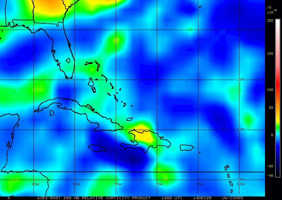
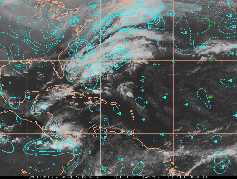
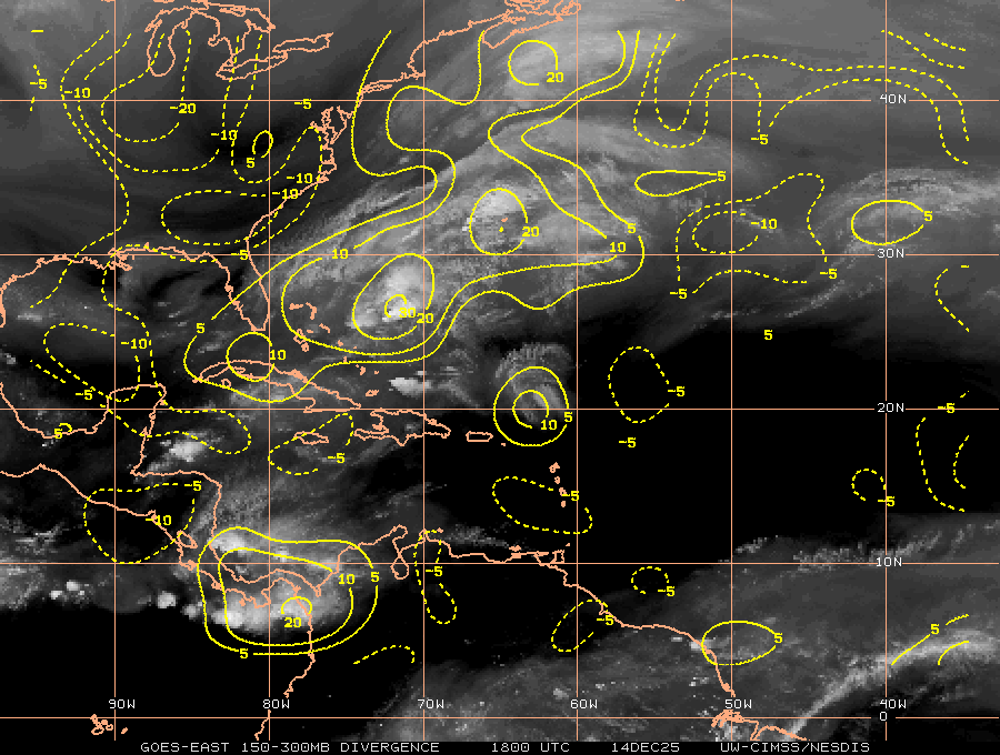
Some rotation down south Mobile, T-storms limited, shear nearby and likely to head NE but maybe a slight chance IHMO probably less than5% but hey it's quiet in here during the peak of Hurricane season.
Pros please wiegh in

850mb voricity
Lower Convergence
Upper Divergence
shear
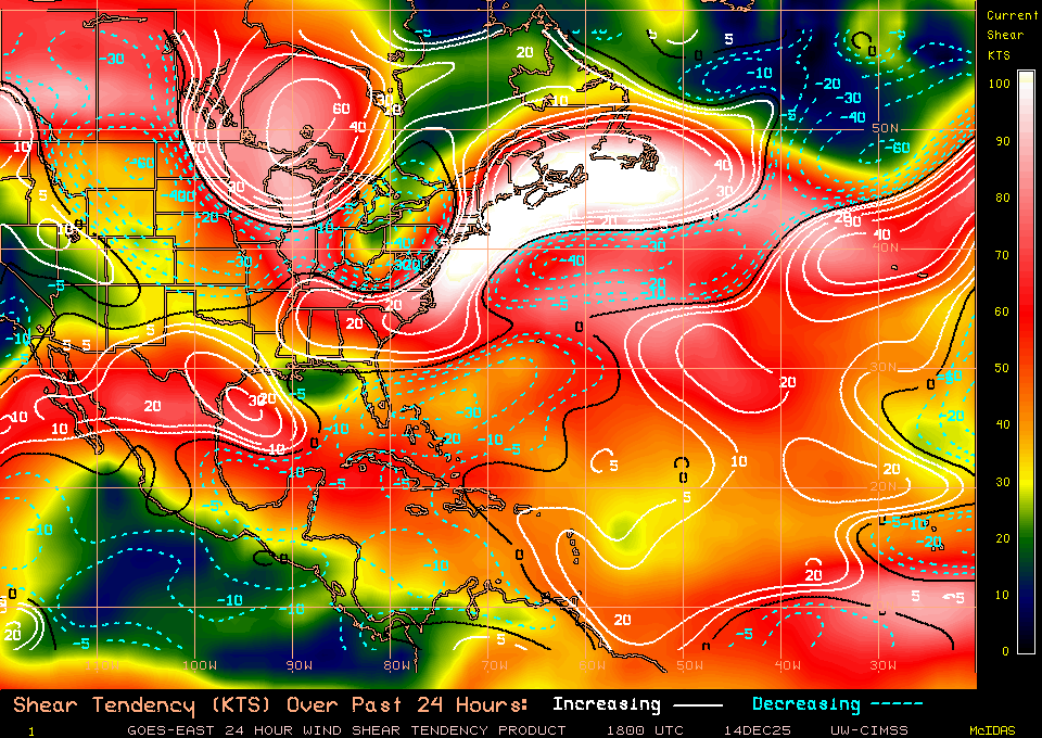
200mb voricity not a good sign for development
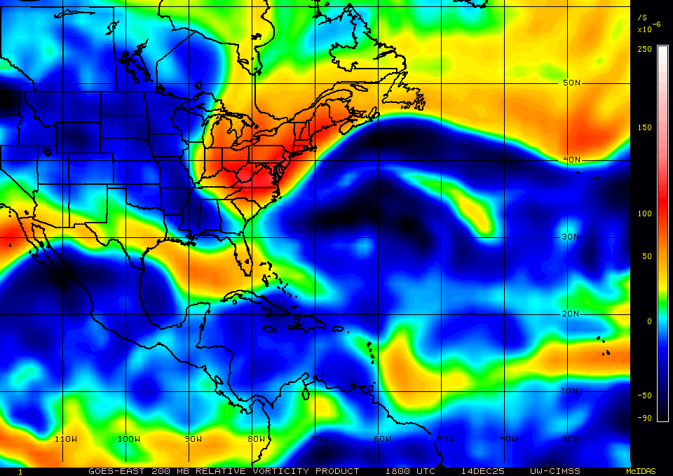
Sorry about all the images
Pros please wiegh in

850mb voricity
Lower Convergence
Upper Divergence
shear
200mb voricity not a good sign for development
Sorry about all the images
0 likes
The following post is NOT an official forecast and should not be used as such. It is just the opinion of the poster and may or may not be backed by sound meteorological data. It is NOT endorsed by any professional institution including storm2k.org For Official Information please refer to the NHC and NWS products.
- TheStormExpert
- Category 5

- Posts: 8487
- Age: 30
- Joined: Wed Feb 16, 2011 5:38 pm
- Location: Palm Beach Gardens, FL
Off topic but, wind shear has seem to calm some throughout the Caribbean (especially NW Caribb.) for now.
0 likes
The following post is NOT an official forecast and should not be used as such. It is just the opinion of the poster and may or may not be backed by sound meteorological data. It is NOT endorsed by storm2k.org.
Who is online
Users browsing this forum: No registered users and 215 guests


