@WPBWeather Yes, my data includes the Euro seasonal forecast, the current state of El Niño and low rainfall amounts across the MDR.
The posts in this forum are NOT official forecast and should not be used as such. They are just the opinion of the poster and may or may not be backed by sound meteorological data. They are NOT endorsed by any professional institution or storm2k.org. For official information, please refer to the NHC and NWS products
2015 indicators: Instability / SST's / MSLP / Steering / Sal
Moderator: S2k Moderators
Forum rules

The posts in this forum are NOT official forecasts and should not be used as such. They are just the opinion of the poster and may or may not be backed by sound meteorological data. They are NOT endorsed by any professional institution or STORM2K. For official information, please refer to products from the National Hurricane Center and National Weather Service.
-
Hybridstorm_November2001

- S2K Supporter

- Posts: 2802
- Joined: Sat Aug 21, 2004 2:50 pm
- Location: SW New Brunswick, Canada
- Contact:

Re: 2015 indicators: Instability / SST's / MSLP / Steering / Sal
MiamiensisWx wrote:As an aside, I just finished some interesting research based on an old theory: that the track and location of the first named storm could offer clues as to how the rest of the storms will track. I looked at all the seasons that I could find in which a) the first named storm hit the U.S. in May or June and 2) was moving between west and north-northwest at landfall. This season, the first named storm, TS Ana, hit the U.S. in May while moving north-northwest.
After research, I found some very startling data that may support what some people have been saying about this season. Overall, the results indicate a strong signal for a FL hurricane threat, with a significant major hurricane threat to the state as well.
The results indicate that such a storm hit in 19 seasons: 1851, 1854, 1871*, 1873*, 1874, 1880*, 1888*, 1899, 1913, 1916, 1921, 1929, 1931, 1939, 1960, 1964*, 1972, 1978, 1993, and 2005*. According to these results, ≈70% of these years had at least one hurricane landfall in FL. Of the years with at least one hurricane strike in FL, ≈57% had at least one major landfall in FL and ≈43%* had two or more hurricanes hitting FL.
Notable storms: major landfalls in 1851 (Cat. 3, NW FL), 1871 (Cat. 3, east-central FL), 1873 (Cat. 3, SW FL), 1888 (Cat. 3, SE FL), 1921 (Cat. 3, Tampa Bay), 1929 (Cat. 3, SE FL), 1960 (Cat. 4 Donna, SE/SW FL), 2005 (Cat. 3 Wilma, SW FL).
Other data: of the years with at least one hurricane hit in FL, ≈57% had at least one hurricane strike on the east coast of the state. 1871 had two hurricanes hitting east-central FL, including one major, plus a Cat. 1 near Cedar Key. 1880 had a Cat. 2 near Melbourne and a Cat. 1 north of Tampa Bay. 1888 had a major hurricane near Miami and a Cat. 2 near Cedar Key. 1929 had a major hurricane near Tavernier in the FL Keys. 1939 had a Cat. 1 near Stuart. 1960 had Donna in the Keys and the SW mainland of FL. 1964 had Cat. 2 Cleo hitting North Miami, Cat. 2 Dora hitting St. Augustine, and Cat. 2 Isbell near Everglades City. 2005 had Cat. 1 Katrina near North Miami and major hurricane Wilma near Cape Romano.
Underline indicates at least one hurricane landfall in FL. Bold indicates at least one major hurricane landfall in FL. * (asterisk) indicates ≥ 2 hurricane hits in FL. Red indicates strong El Niño seasons.
I happen to fully agree that correlations do often exist, which are indicative of seasonal patterns regarding the formation and general track motion of tropical cyclones. To differing levels I have found many seasons to exhibit "pairing" or clusters of tropical cyclones to either form and/or move in like manners. While not exact, I think there is a good deal more support to suggest that some "hot spots" may be identified for potential track risk, than assuming that most seasons will simply exhibit random variability when it comes to location and direction of storm tracks.
I think that when you just simply break down the potential "RISK" factors which might imply a coastal area to have a lower risk, average risk, or perhaps a far greater risk than normal of getting hit by a storm in any one given year, the shear quantity or number of storms definitely play a factor (odds are greater of any point on a map of getting hit by a tropical storm if 18 form that year rather than if only 5 form). Obviously the point where a tropical system originates plays into what the downstream risk might be for different regions too (A Cape Verde system and a storm forming in the BOC pose different risks to Brownsville Tx. as an example). Of course the 500mb pattern has everything to do with whether any particular storm may/may not move within 1,000 miles of a given point. Finally, beyond steering and even overall Atlantic basin favorable (or unfavorable) condition dynamics for cyclone development, there are those regional or more local variable conditions which impact rapid intensification or weakening for individual storms, temporary or dynamic conditions that may cause a storm to stall, suddenly move faster, conditions causing a storm to "spin up" fairly quickly, or weaken, or become extra-tropical, etc.
If i'm hoping to chase a land-falling major hurricane this year, i'd agree that those odds are less likely (okay, maybe a lot less likely
This first 10 days of July is a statistical slow period each hurricane season for the Atlantic. Overall, surface, mid and upper level dynamic conditions might well remain largely unfavorable for much of the MDR and the tropics as a whole. This year's gonna be about spotting those relative few regions or small area "sweet spots" where somewhat favorable conditions might be forecast to exist, even if only temporarily favorable. As a hint, one point to keep an eye on is where Mother Nature has already tipped her hand this year
0 likes
Personal Forecast Disclaimer:
The posts in this forum are NOT official forecast and should not be used as such. They are just the opinion of the poster and may or may not be backed by sound meteorological data. They are NOT endorsed by any professional institution or storm2k.org. For official information, please refer to the NHC and NWS products.
The posts in this forum are NOT official forecast and should not be used as such. They are just the opinion of the poster and may or may not be backed by sound meteorological data. They are NOT endorsed by any professional institution or storm2k.org. For official information, please refer to the NHC and NWS products.

80-90kts of shear again next week in the Carib, thats got to be some kind of record for July, wxman57?
0 likes
The above post and any post by Ntxw is NOT an official forecast and should not be used as such. It is just the opinion of the poster and may or may not be backed by sound meteorological data. It is NOT endorsed by any professional institution including Storm2k. For official information, please refer to NWS products.
Help support Storm2K!
-
wxman57

- Moderator-Pro Met

- Posts: 22482
- Age: 66
- Joined: Sat Jun 21, 2003 8:06 pm
- Location: Houston, TX (southwest)
Re:
Ntxw wrote:80-90kts of shear again next week in the Carib, thats got to be some kind of record for July, wxman57?
I saw a tweet by Phil Klotzbach about that yesterday. He said it's second only to 2014.
0 likes
-
ninel conde
- Category 5

- Posts: 1245
- Joined: Mon Aug 04, 2008 2:18 pm
Re:
Ntxw wrote:80-90kts of shear again next week in the Carib, thats got to be some kind of record for July, wxman57?
http://moe.met.fsu.edu/cgi-bin/gfstc2.c ... hour=180hr
amazingly constant non changing pattern. can easily see in that map why we have such storm ripping shear and bone dry air flooding the tropics.
0 likes
The posts in this forum are NOT official forecast and should not be used as such. They are just the opinion of the poster and may or may not be backed by sound meteorological data. They are NOT endorsed by any professional institution or storm2k.org. For official information, please refer to the NHC and NWS products.
-
Hurricaneman

- Category 5
- Posts: 7281
- Age: 43
- Joined: Tue Aug 31, 2004 3:24 pm
- Location: central florida
Re: 2015 indicators: Instability / SST's / MSLP / Steering / Sal
Based on the forecasted MJO I would watch off the East Coast to GOM for tropical development between July18th and 25th because there will probably be more instability coming into the Atlantic near that time and the places mentioned have had very low shear which could be bad if coupled with the forecasted MJO pulse
The posts in this forum are NOT official forecast and should not be used as such. They are just the opinion of the poster and may or may not be backed by sound meteorological data. They are NOT endorsed by any professional institution or storm2k.org. For official information, please refer to the NHC and NWS products
The posts in this forum are NOT official forecast and should not be used as such. They are just the opinion of the poster and may or may not be backed by sound meteorological data. They are NOT endorsed by any professional institution or storm2k.org. For official information, please refer to the NHC and NWS products
0 likes
-
ninel conde
- Category 5
- Posts: 1245
- Joined: Mon Aug 04, 2008 2:18 pm
maybe way off the east coast with this non stop flood pattern. Storm2k may be a bit slow the next few months with both LC and JB not even mentioning the atlantic lately.
0 likes
The posts in this forum are NOT official forecast and should not be used as such. They are just the opinion of the poster and may or may not be backed by sound meteorological data. They are NOT endorsed by any professional institution or storm2k.org. For official information, please refer to the NHC and NWS products.
-
cycloneye

- Admin

- Posts: 139075
- Age: 67
- Joined: Thu Oct 10, 2002 10:54 am
- Location: San Juan, Puerto Rico
Re: 2015 indicators: Instability / SST's / MSLP / Steering / Sal
Interesting from this fellow that all know. 
Eric Blake @EricBlake12 · 13m13 minutes ago
Interesting little midwestern low forecast to be off the E. Coast in a few days- best chance to me since Bill #ElNino

Eric Blake @EricBlake12 · 13m13 minutes ago
Interesting little midwestern low forecast to be off the E. Coast in a few days- best chance to me since Bill #ElNino
0 likes
Visit the Caribbean-Central America Weather Thread where you can find at first post web cams,radars
and observations from Caribbean basin members Click Here
and observations from Caribbean basin members Click Here
-
ninel conde
- Category 5
- Posts: 1245
- Joined: Mon Aug 04, 2008 2:18 pm
https://pbs.twimg.com/media/CJoXjJlUEAAUrY7.png
East coast trof in full force and effect. JB says that a non tropical low well off the coast. Huge monster trof for july and expect them bigger and meaner in aug/sept.
East coast trof in full force and effect. JB says that a non tropical low well off the coast. Huge monster trof for july and expect them bigger and meaner in aug/sept.
0 likes
The posts in this forum are NOT official forecast and should not be used as such. They are just the opinion of the poster and may or may not be backed by sound meteorological data. They are NOT endorsed by any professional institution or storm2k.org. For official information, please refer to the NHC and NWS products.
-
wxman57
- Moderator-Pro Met
- Posts: 22482
- Age: 66
- Joined: Sat Jun 21, 2003 8:06 pm
- Location: Houston, TX (southwest)
Re: 2015 indicators: Instability / SST's / MSLP / Steering / Sal
Instability is WAY down in the Caribbean & Tropical Atlantic while shear is at an all-time high in the Caribbean. Translates to a "dead" Caribbean this year. Not much rain for the islands, either.


Caribbean Shear:
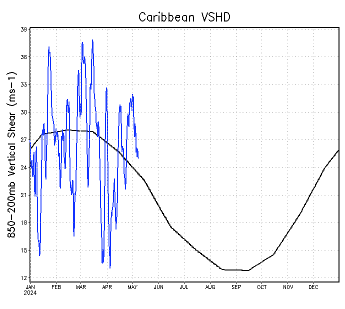
Caribbean Shear:
0 likes
-
WPBWeather

- S2K Supporter
- Posts: 535
- Age: 65
- Joined: Thu Jul 18, 2013 12:33 pm
Re:
ninel conde wrote:https://pbs.twimg.com/media/CJoXjJlUEAAUrY7.png
East coast trof in full force and effect. JB says that a non tropical low well off the coast. Huge monster trof for july and expect them bigger and meaner in aug/sept.
Come on, confess. Are you really JB in disguise??
0 likes

-
ninel conde
- Category 5
- Posts: 1245
- Joined: Mon Aug 04, 2008 2:18 pm
Re:
galaxy401 wrote:Hasn't the Caribbean been dead since 2012 and to a lesser extent 2009?
Pretty much.
0 likes
The posts in this forum are NOT official forecast and should not be used as such. They are just the opinion of the poster and may or may not be backed by sound meteorological data. They are NOT endorsed by any professional institution or storm2k.org. For official information, please refer to the NHC and NWS products.

Re:
galaxy401 wrote:Hasn't the Caribbean been dead since 2012 and to a lesser extent 2009?
Since 2013. I wouldn't say 2009 given there have been 7 hurricanes from 2009-12, and each year had at least one of Cat 2 intensity or higher. We only have two full seasons to sample since then, though of the two Caribbean storms, one didn't become named until it reached the BoC, the other was named there but originated in the BoC.
0 likes
The above post is not official and should not be used as such. It is the opinion of the poster and may or may not be backed by sound meteorological data. It is not endorsed by any professional institution or storm2k.org. For official information, please refer to the NHC and NWS products.
-
CYCLONE MIKE
- Category 5
- Posts: 2183
- Joined: Tue Aug 31, 2004 6:04 pm
- Location: Gonzales, LA
Re: 2015 indicators: Instability / SST's / MSLP / Steering / Sal
Instability is WAY down in the Caribbean & Tropical Atlantic while shear is at an all-time high in the Caribbean. Translates to a "dead" Caribbean this year. Not much rain for the islands, either.
But, but, but August and September are not even here yet
0 likes
-
Yellow Evan

- Professional-Met

- Posts: 15952
- Age: 25
- Joined: Fri Jul 15, 2011 12:48 pm
- Location: Henderson, Nevada/Honolulu, HI
- Contact:
Re: 2015 indicators: Instability / SST's / MSLP / Steering / Sal
CYCLONE MIKE wrote:Instability is WAY down in the Caribbean & Tropical Atlantic while shear is at an all-time high in the Caribbean. Translates to a "dead" Caribbean this year. Not much rain for the islands, either.
But, but, but August and September are not even here yet
Well the tropics have a lot of catching up to do. Ill keep it at that.
0 likes
Re: 2015 indicators: Instability / SST's / MSLP / Steering / Sal
Yellow Evan wrote:Well the tropics have a lot of catching up to do. Ill keep it at that.
In terms of numbers, I'm not sure what catching up you're referring to, it likely won't stay this way but we're ahead of the average formation points, with the first storm not normally forming until about now, and the next storm (as well as first hurricane) not forming on average until the second week of August.
0 likes
The above post is not official and should not be used as such. It is the opinion of the poster and may or may not be backed by sound meteorological data. It is not endorsed by any professional institution or storm2k.org. For official information, please refer to the NHC and NWS products.
-
CrazyC83
- Professional-Met
- Posts: 33393
- Joined: Tue Mar 07, 2006 11:57 pm
- Location: Deep South, for the first time!
Re: 2015 indicators: Instability / SST's / MSLP / Steering / Sal
Hammy wrote:Yellow Evan wrote:Well the tropics have a lot of catching up to do. Ill keep it at that.
In terms of numbers, I'm not sure what catching up you're referring to, it likely won't stay this way but we're ahead of the average formation points, with the first storm not normally forming until about now, and the next storm (as well as first hurricane) not forming on average until the second week of August.
These kind of seasons can often throw the calendar off. Look at 1997 - was near-record activity by late July, then August was dead and September had only one storm (a major hurricane, mind you). For all we know, November could be more active than August or September this year.
I'd pretty much expect all activity in 2015 to take place north of 25N latitude, in the subtropical Atlantic (and off the east coast) and in the northern Gulf of Mexico.
0 likes
-
Yellow Evan
- Professional-Met
- Posts: 15952
- Age: 25
- Joined: Fri Jul 15, 2011 12:48 pm
- Location: Henderson, Nevada/Honolulu, HI
- Contact:
Re: 2015 indicators: Instability / SST's / MSLP / Steering / Sal
Hammy wrote:Yellow Evan wrote:Well the tropics have a lot of catching up to do. Ill keep it at that.
In terms of numbers, I'm not sure what catching up you're referring to, it likely won't stay this way but we're ahead of the average formation points, with the first storm not normally forming until about now, and the next storm (as well as first hurricane) not forming on average until the second week of August.
I wasn't talking about numbers. I was talking about record low instability and record high shear. If the ATL wants to get to normal levels, it's got a lot of catching up to do.
0 likes
-
ninel conde
- Category 5
- Posts: 1245
- Joined: Mon Aug 04, 2008 2:18 pm
LC DOES NOT back down:
"While this is unlikely to be a big "Cape Verde" storm year, I still think that the Caribbean Sea, Gulf of Mexico, and Sargasso Sea will provide more action in the tropics than last year. My call for 14 named storms before November 31 remains. I also think that we may be in for an East Coast surprise in October."
if we arent allowed to quote him please delete.
0 likes
The posts in this forum are NOT official forecast and should not be used as such. They are just the opinion of the poster and may or may not be backed by sound meteorological data. They are NOT endorsed by any professional institution or storm2k.org. For official information, please refer to the NHC and NWS products.
Who is online
Users browsing this forum: Google Adsense [Bot], Hurricane2022, kevin, Lizzytiz1, NotSparta and 216 guests