2015 indicators: Instability / SST's / MSLP / Steering / Sal

This is the general tropical discussion area. Anyone can take their shot at predicting a storms path.

Moderator: S2k Moderators

Forum rules

The posts in this forum are NOT official forecasts and should not be used as such. They are just the opinion of the poster and may or may not be backed by sound meteorological data. They are NOT endorsed by any professional institution or STORM2K. For official information, please refer to products from the National Hurricane Center and National Weather Service.

Help Support Storm2K
Message
Author
User avatar
cycloneye
Admin
Admin
Posts: 139041
Age: 67
Joined: Thu Oct 10, 2002 10:54 am
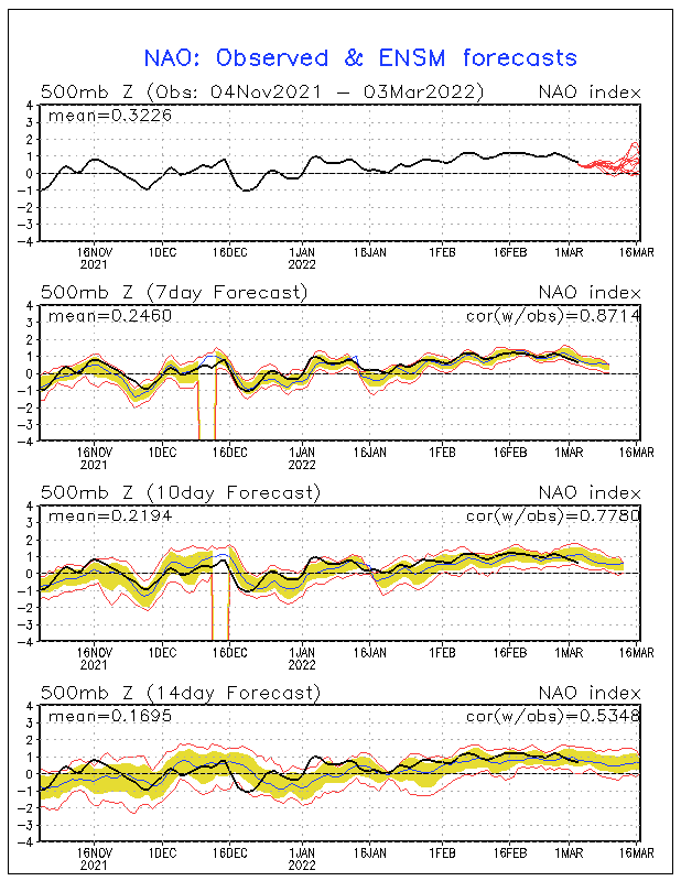
Location: San Juan, Puerto Rico

2015 indicators: Instability / SST's / MSLP / Steering / Sal

#1 Postby cycloneye » Thu Jan 01, 2015 9:54 am

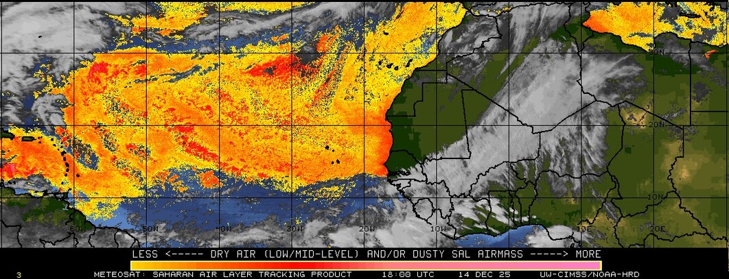
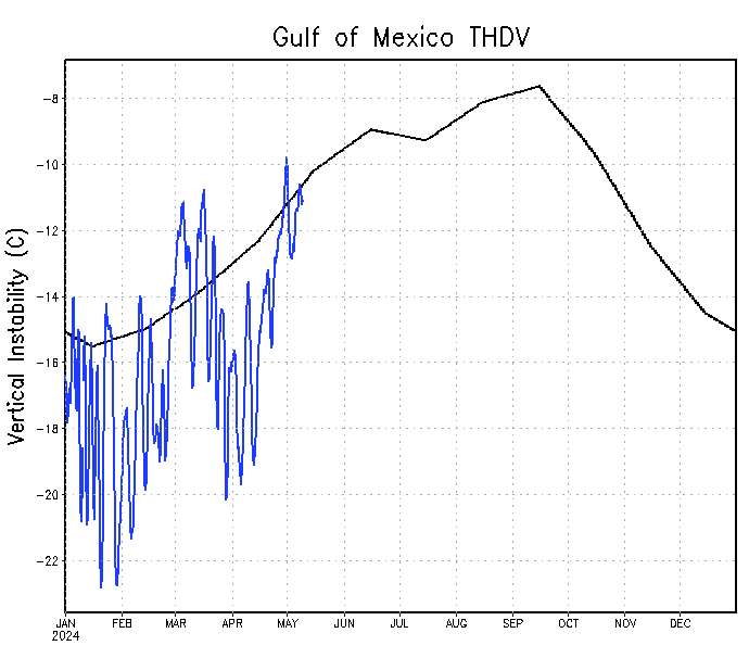
This topic for the 2015 North Atlantic indicators is important to have this early to see how things are evolving in the important factor of the steering as we will see based on that which areas in the basin may have visits of tropical systems. Also,it will be important to see how the pressures will be and how the waters are in terms of being more warm or not. And last but also important is how things are evolving in the Vertical Instability factor.Let's see how things evolve in the next few months. Post away your takes folks.

Note=This thread is not to post forecast numbers but to discuss about how things are going in the factors this thread is enlisting. There will be our annual poll for that starting on April 1rst. As a matter of fact,this thread will help you a bit to decide about the numbers game with all the information that will be posted.

Image

Image

Image

http://www.ssd.noaa.gov/PS/TROP/TCFP/atlantic.html


http://www.aoml.noaa.gov/phod/cyclone/data/at.html


Image


Image

Image

Image

Image

Image

Image

http://www.tropicaltidbits.com/analysis/ocean.html

Image

http://www.ecmwf.int/en/forecasts/charts/catalogue?f[0]=im_field_chart_type_2%3A607&amp%3Bf[1]=im_field_chart_type%3A482

Image

http://www.cpc.ncep.noaa.gov/products/p ... /nao.shtml

Image

http://tropic.ssec.wisc.edu/real-time/s ... od=splitEW
0 likes   
Visit the Caribbean-Central America Weather Thread where you can find at first post web cams,radars
and observations from Caribbean basin members Click Here

User avatar
TheStormExpert
Category 5
Category 5
Posts: 8487
Age: 30
Joined: Wed Feb 16, 2011 5:38 pm
Location: Palm Beach Gardens, FL

#2 Postby TheStormExpert » Thu Jan 01, 2015 7:30 pm

IMO the lack of vertical instability will remain a huge problem especially in the Tropical Atlantic at least until we can actually get a decent El Niño event to come and go. Until that happens do not expect a spike to normal/above normal vertical instability.
0 likes   
The following post is NOT an official forecast and should not be used as such. It is just the opinion of the poster and may or may not be backed by sound meteorological data. It is NOT endorsed by storm2k.org.

User avatar
cycloneye
Admin
Admin
Posts: 139041
Age: 67
Joined: Thu Oct 10, 2002 10:54 am
Location: San Juan, Puerto Rico

Re: 2015 N.Atl indicators:V.Instability / SST's / MSLP /Steering

#3 Postby cycloneye » Sat Jan 03, 2015 8:14 pm

Well,so far in the first 3 days of 2015 at least the Vertical Instability in the Tropical Atlantic is near normal but of course it will change constantly so let's watch that. Also the sst anomalies in the Eastern Atlantic are :cold: but again let's see how it goes as time goes by.
0 likes   
Visit the Caribbean-Central America Weather Thread where you can find at first post web cams,radars
and observations from Caribbean basin members Click Here
User avatar
TropicalAnalystwx13
Category 5
Category 5
Posts: 2109
Age: 26
Joined: Tue Jul 19, 2011 8:20 pm
Location: Wilmington, NC
Contact:

#4 Postby TropicalAnalystwx13 » Mon Jan 05, 2015 12:39 pm

Trends in the IOD, AMO, and ENSO are the three main factors I'm looking out for this upcoming season. The IOD is currently cool Neutral, with guidance indicating a continuation of Neutral conditions or a dip into negative territory over the summer months. Remember that a negative IOD favors more robust tropical waves, increasing the odds for development later down the road. The AMO remains only marginally positive, not uncharacteristic of the past few years. If the AMO continues to be this weak, we should see average or slightly below-average SSTs across the tropical Atlantic (not a favorable configuration to focus upward motion in the basin). And then there's ENSO...and what a hassle it has been the past few years. Waters remain anomalously warm across the Pacific, and as long as that continues to be the case, we should see above-average shear across the West Atlantic. The degree of shear will be determined by the placement and intensity of the warmest waters relative to average.
0 likes   

User avatar
cycloneye
Admin
Admin
Posts: 139041
Age: 67
Joined: Thu Oct 10, 2002 10:54 am
Location: San Juan, Puerto Rico

Re:

#5 Postby cycloneye » Mon Jan 05, 2015 1:10 pm

TropicalAnalystwx13 wrote:Trends in the IOD, AMO, and ENSO are the three main factors I'm looking out for this upcoming season. The IOD is currently cool Neutral, with guidance indicating a continuation of Neutral conditions or a dip into negative territory over the summer months. Remember that a negative IOD favors more robust tropical waves, increasing the odds for development later down the road. The AMO remains only marginally positive, not uncharacteristic of the past few years. If the AMO continues to be this weak, we should see average or slightly below-average SSTs across the tropical Atlantic (not a favorable configuration to focus upward motion in the basin). And then there's ENSO...and what a hassle it has been the past few years. Waters remain anomalously warm across the Pacific, and as long as that continues to be the case, we should see above-average shear across the West Atlantic. The degree of shear will be determined by the placement and intensity of the warmest waters relative to average.


Is a big if at this time that El Nino is up soon so any warm episode would be a Modoki one if Nino 1+2 doesn't go above +0.5C. (Well in Neutral on January 5) That would be good for North Atlantic Hurricane Season to be more active but other factors may cancel that like the Thermoline Circulation,,cooler sst's,Vertical Instability etc.
0 likes   
Visit the Caribbean-Central America Weather Thread where you can find at first post web cams,radars
and observations from Caribbean basin members Click Here

User avatar
gatorcane
S2K Supporter
S2K Supporter
Posts: 23499
Age: 46
Joined: Sun Mar 13, 2005 3:54 pm
Location: Boca Raton, FL

#6 Postby gatorcane » Mon Jan 12, 2015 10:47 am

One thing we would want to see for an active Atlantic season that could cause potential impacts for the U.S. and Caribbean are warmer SST anomalies in the tropics rather than subtropics but that is not what we are seeing right now as the warmest anomalies are north of 30N across the subtropical Atlantic. Still a lot of time for things to change though:

Image
0 likes   

CrazyC83
Professional-Met
Professional-Met
Posts: 33393
Joined: Tue Mar 07, 2006 11:57 pm
Location: Deep South, for the first time!

#7 Postby CrazyC83 » Mon Jan 12, 2015 9:12 pm

It seems there are mixed signals, but you can't really predict much from January.

Having three lower-activity seasons in a row would be quite rare though...
0 likes   

User avatar
TheStormExpert
Category 5
Category 5
Posts: 8487
Age: 30
Joined: Wed Feb 16, 2011 5:38 pm
Location: Palm Beach Gardens, FL

#8 Postby TheStormExpert » Mon Jan 12, 2015 9:49 pm

By looking at the Caribbean Vertical Instability chart and Sea Level Pressure forecast the Caribbean COULD be the hotspot this year if trends continue and of course waters warm to levels similar to last season.

Though things could and will change and this may not even be the case at all come June.
0 likes   
The following post is NOT an official forecast and should not be used as such. It is just the opinion of the poster and may or may not be backed by sound meteorological data. It is NOT endorsed by storm2k.org.

User avatar
cycloneye
Admin
Admin
Posts: 139041
Age: 67
Joined: Thu Oct 10, 2002 10:54 am
Location: San Juan, Puerto Rico

Re:

#9 Postby cycloneye » Mon Jan 12, 2015 10:19 pm

TheStormExpert wrote:By looking at the Caribbean Vertical Instability chart and Sea Level Pressure forecast the Caribbean COULD be the hotspot this year if trends continue and of course waters warm to levels similar to last season.

Though things could and will change and this may not even be the case at all come June.


You may be right about Caribbean being a hot spot but many things will happen from now going thru the next few months to be sure. Let's keep checking those graphics that update every day at first post.
0 likes   
Visit the Caribbean-Central America Weather Thread where you can find at first post web cams,radars
and observations from Caribbean basin members Click Here

CrazyC83
Professional-Met
Professional-Met
Posts: 33393
Joined: Tue Mar 07, 2006 11:57 pm
Location: Deep South, for the first time!

#10 Postby CrazyC83 » Wed Jan 14, 2015 3:31 pm

The closest recent analog I can come up with might be 2007, although 2002, 1998, 1988, 1985 and 1979 might also be reasonable analogs. For the most part Cape Verde was dead in those years, but they did produce stronger storms west of 60W (and especially west of 75W).
0 likes   

User avatar
cycloneye
Admin
Admin
Posts: 139041
Age: 67
Joined: Thu Oct 10, 2002 10:54 am
Location: San Juan, Puerto Rico

Re: 2015 N.Atl indicators:V.Instability / SST's / MSLP /Steering

#11 Postby cycloneye » Thu Jan 15, 2015 11:18 am

The January update of the MSLP by operational ECMWF is terrible so far for the North Atlantic with very high pressures as it goes thru May,June and July.The ECMWF ensembles are with near normal pressures for the same period.

Operational:

Image

Ensembles

Image

ECMWF MSLP forecast
0 likes   
Visit the Caribbean-Central America Weather Thread where you can find at first post web cams,radars
and observations from Caribbean basin members Click Here

User avatar
cycloneye
Admin
Admin
Posts: 139041
Age: 67
Joined: Thu Oct 10, 2002 10:54 am
Location: San Juan, Puerto Rico

Re:

#12 Postby cycloneye » Thu Jan 15, 2015 4:13 pm

CrazyC83 wrote:The closest recent analog I can come up with might be 2007, although 2002, 1998, 1988, 1985 and 1979 might also be reasonable analogs. For the most part Cape Verde was dead in those years, but they did produce stronger storms west of 60W (and especially west of 75W).


Why you think 2007?
0 likes   
Visit the Caribbean-Central America Weather Thread where you can find at first post web cams,radars
and observations from Caribbean basin members Click Here

User avatar
TheStormExpert
Category 5
Category 5
Posts: 8487
Age: 30
Joined: Wed Feb 16, 2011 5:38 pm
Location: Palm Beach Gardens, FL

Re: 2015 N.Atl indicators:V.Instability / SST's / MSLP /Steering

#13 Postby TheStormExpert » Thu Jan 15, 2015 11:40 pm

cycloneye wrote:The January update of the MSLP by operational ECMWF is terrible so far for the North Atlantic with very high pressures as it goes thru May,June and July.The ECMWF ensembles are with near normal pressures for the same period.

Operational:

http://oi60.tinypic.com/2uqdpnc.jpg

Ensembles

http://oi59.tinypic.com/dvlie8.jpg

ECMWF MSLP forecast

Just looking at this wouldn't this mean that both the Atlantic and E. Pacific be below average in activity?
0 likes   
The following post is NOT an official forecast and should not be used as such. It is just the opinion of the poster and may or may not be backed by sound meteorological data. It is NOT endorsed by storm2k.org.

User avatar
Yellow Evan
Professional-Met
Professional-Met
Posts: 15951
Age: 25
Joined: Fri Jul 15, 2011 12:48 pm
Location: Henderson, Nevada/Honolulu, HI
Contact:

Re: 2015 N.Atl indicators:V.Instability / SST's / MSLP /Steering

#14 Postby Yellow Evan » Fri Jan 16, 2015 12:34 am

TheStormExpert wrote:
cycloneye wrote:The January update of the MSLP by operational ECMWF is terrible so far for the North Atlantic with very high pressures as it goes thru May,June and July.The ECMWF ensembles are with near normal pressures for the same period.

Operational:

http://oi60.tinypic.com/2uqdpnc.jpg

Ensembles

http://oi59.tinypic.com/dvlie8.jpg

ECMWF MSLP forecast

Just looking at this wouldn't this mean that both the Atlantic and E. Pacific be below average in activity?


ATL? Yes EPAC? No. That's an El Nino like setup the Euro shows.
0 likes   

User avatar
cycloneye
Admin
Admin
Posts: 139041
Age: 67
Joined: Thu Oct 10, 2002 10:54 am
Location: San Juan, Puerto Rico

Re: 2015 N.Atl indicators:V.Instability / SST's / MSLP /Steering

#15 Postby cycloneye » Sun Jan 18, 2015 4:26 pm

If the NAO remains positive as it is now it would not allow the sst's to warm a lot.But the position and strength of the Azores and Bermuda highs will be key on the steering.Let's continue to watch how the NAO behaves in the next 7-8 months.
0 likes   
Visit the Caribbean-Central America Weather Thread where you can find at first post web cams,radars
and observations from Caribbean basin members Click Here

User avatar
blp
Category 5
Category 5
Posts: 2805
Age: 45
Joined: Thu Sep 09, 2004 7:51 pm
Location: Miami, FL
Contact:

Re: 2015 N.Atl indicators:V.Instability / SST's / MSLP /Steering

#16 Postby blp » Mon Jan 19, 2015 10:57 am

cycloneye wrote:If the NAO remains positive as it is now it would not allow the sst's to warm a lot.But the position and strength of the Azores and Bermuda highs will be key on the steering.Let's continue to watch how the NAO behaves in the next 7-8 months.


Good point. I am interested in how the steering will evolve this year. After 5 years of dominant troughs helping to steer storms away from many land areas I would think that it will flip back soon. I would think that Bermuda would be happy to see that pattern change since they have been affected quite frequently lately.
0 likes   
The following post is NOT an official forecast and should not be used as such. It is just the opinion of the poster and may or may not be backed by sound meteorological data. It is NOT endorsed by any professional institution including storm2k.org For Official Information please refer to the NHC and NWS products.

User avatar
cycloneye
Admin
Admin
Posts: 139041
Age: 67
Joined: Thu Oct 10, 2002 10:54 am
Location: San Juan, Puerto Rico

Re: 2015 N.Atl indicators:V.Instability / SST's / MSLP /Steering

#17 Postby cycloneye » Fri Jan 23, 2015 3:28 pm

Hey folks,dont say it loud but the Tropical Atlantic Vertical Instability is above normal for January 23rd. :) But is a very long road ahead.
0 likes   
Visit the Caribbean-Central America Weather Thread where you can find at first post web cams,radars
and observations from Caribbean basin members Click Here

User avatar
cycloneye
Admin
Admin
Posts: 139041
Age: 67
Joined: Thu Oct 10, 2002 10:54 am
Location: San Juan, Puerto Rico

Re: 2015 N.Atl indicators:V.Instability / SST's / MSLP /Steering

#18 Postby cycloneye » Wed Jan 28, 2015 5:40 pm

As the first month of 2015 comes to an end we are looking at negative things gong on in terms of the next North Atlantic Hurricane Season.Vertical Instability is way down as of January 28 everywhere,the forecast for MSLP is not good and the sst's are not warming.Let's see what Febuary and the next few months have to see if things turn a little bit better.
0 likes   
Visit the Caribbean-Central America Weather Thread where you can find at first post web cams,radars
and observations from Caribbean basin members Click Here

CrazyC83
Professional-Met
Professional-Met
Posts: 33393
Joined: Tue Mar 07, 2006 11:57 pm
Location: Deep South, for the first time!

Re: Re:

#19 Postby CrazyC83 » Fri Jan 30, 2015 2:04 pm

cycloneye wrote:
CrazyC83 wrote:The closest recent analog I can come up with might be 2007, although 2002, 1998, 1988, 1985 and 1979 might also be reasonable analogs. For the most part Cape Verde was dead in those years, but they did produce stronger storms west of 60W (and especially west of 75W).


Why you think 2007?


Moderate activity in those years, heavy focus on the western part of the basin (i.e. Caribbean, Gulf of Mexico) and Cape Verde incredibly hostile. 2007 fit that pattern quite well.
0 likes   

User avatar
cycloneye
Admin
Admin
Posts: 139041
Age: 67
Joined: Thu Oct 10, 2002 10:54 am
Location: San Juan, Puerto Rico

Re: 2015 indicators: Instability / SST's / MSLP / Steering / Sal

#20 Postby cycloneye » Sat Jan 31, 2015 2:58 pm

I included to the title of thread and added the graphic of the Saharan air Layer factor as that is another indicator that we have to look at.As January ends there is a fair amount of sal in the Tropical Atlantic.
0 likes   
Visit the Caribbean-Central America Weather Thread where you can find at first post web cams,radars
and observations from Caribbean basin members Click Here


Return to “Talkin' Tropics”

Who is online

Users browsing this forum: No registered users and 82 guests