2015 indicators: Instability / SST's / MSLP / Steering / Sal
Moderator: S2k Moderators
Forum rules

The posts in this forum are NOT official forecasts and should not be used as such. They are just the opinion of the poster and may or may not be backed by sound meteorological data. They are NOT endorsed by any professional institution or STORM2K. For official information, please refer to products from the National Hurricane Center and National Weather Service.
-
cycloneye

- Admin

- Posts: 139025
- Age: 67
- Joined: Thu Oct 10, 2002 10:54 am
- Location: San Juan, Puerto Rico
Re: 2015 indicators: Instability / SST's / MSLP / Steering / Sal
The only place favorable as of March 22nd is the GOM but will it continue this way when it counts in the Summer months? I know JB has mentioned recently it may aid for a major cane to strike the gulf coast but I don't go that far and prefer to wait and see how things evolve.
0 likes
Visit the Caribbean-Central America Weather Thread where you can find at first post web cams,radars
and observations from Caribbean basin members Click Here
and observations from Caribbean basin members Click Here
-
Yellow Evan

- Professional-Met

- Posts: 15951
- Age: 25
- Joined: Fri Jul 15, 2011 12:48 pm
- Location: Henderson, Nevada/Honolulu, HI
- Contact:

-
cycloneye
- Admin
- Posts: 139025
- Age: 67
- Joined: Thu Oct 10, 2002 10:54 am
- Location: San Juan, Puerto Rico
Re:
CrazyC83 wrote:But any waves would dissipate long before reaching the GOM in such a dry, stable environment? That means they would likely have to come from non-tropical origins.
Homegrown activity may be more favored even if there is only one forming in 2015.
0 likes
Visit the Caribbean-Central America Weather Thread where you can find at first post web cams,radars
and observations from Caribbean basin members Click Here
and observations from Caribbean basin members Click Here
-
CrazyC83
- Professional-Met
- Posts: 33393
- Joined: Tue Mar 07, 2006 11:57 pm
- Location: Deep South, for the first time!
Re: Re:
cycloneye wrote:CrazyC83 wrote:But any waves would dissipate long before reaching the GOM in such a dry, stable environment? That means they would likely have to come from non-tropical origins.
Homegrown activity may be more favored even if there is only one forming in 2015.GOM and off SE U.S coast.
I believe in 2014, 3 or 4 of the 8 named storms (Arthur, Cristobal?, Fay and Hanna) came from non-tropical sources.
If non-tropical sources are the likely culprits, I would think the very early season (i.e. June especially) and later in the season (mid to late September onward) would be the busiest months. August would likely be quiet except for weak dusty lows.
0 likes
-
ninel conde
- Category 5

- Posts: 1245
- Joined: Mon Aug 04, 2008 2:18 pm
LC still bullish on the upcoming season.
0 likes
The posts in this forum are NOT official forecast and should not be used as such. They are just the opinion of the poster and may or may not be backed by sound meteorological data. They are NOT endorsed by any professional institution or storm2k.org. For official information, please refer to the NHC and NWS products.

Re: Re:
TropicalAnalystwx13 wrote:Steve wrote:xcool22 wrote:I really think active era ended imo
You should probably watch Joe B's Saturday summary today on weatherbell. He notes that there is a sign of a cold amo and warm pdo, but he feels like it's a temporary move for the amo in line with the late 50s before the return to the warm period which I believe lasted through 1969. Interestingly, he said they believe the usa will sustain a major hit this year based on what's likely to be an extremely warm Gulf in an otherwise down year. What wasn't clear was the use of the word major in "major hit." For instance I wasn't clear if he was calling for the U.S. to be hit by a major or if there would just be a major impact which obviously could happen in a below IH Storm. You'd have to think eastern Gulf, Florida or the Carolinas if the warm Gulf was to be a factor.
Anybody who claims the U.S. will see a major hit just because SSTs are above average shouldn't be trusted. The atmosphere dictates, always.
I'm not making a value judgment on the individual making that claim. It was an aside to someone who said they felt like the active era was over, and I had just watched the video a few minutes before running across the comment. He may be right (or not) on the temporary pulse to cold ahead of the eventual move to the cold AMO, or he might be wrong. He also may or may not be right over the major hit. We won't know for another 5-6 months. But I'm sure it's not 100% based on the eventually warm Gulf, but that's one of the reasons he put out there "in an otherwise down year." It happens or it doesn't, and I don't take things he says as the Gospel Truth. But he isn't someone to just automatically discount (in my opinion).
0 likes
-
cycloneye
- Admin
- Posts: 139025
- Age: 67
- Joined: Thu Oct 10, 2002 10:54 am
- Location: San Juan, Puerto Rico
Re:
TropicalAnalystwx13 wrote:Trends in the IOD, AMO, and ENSO are the three main factors I'm looking out for this upcoming season. The IOD is currently cool Neutral, with guidance indicating a continuation of Neutral conditions or a dip into negative territory over the summer months. Remember that a negative IOD favors more robust tropical waves, increasing the odds for development later down the road. The AMO remains only marginally positive, not uncharacteristic of the past few years. If the AMO continues to be this weak, we should see average or slightly below-average SSTs across the tropical Atlantic (not a favorable configuration to focus upward motion in the basin). And then there's ENSO...and what a hassle it has been the past few years. Waters remain anomalously warm across the Pacific, and as long as that continues to be the case, we should see above-average shear across the West Atlantic. The degree of shear will be determined by the placement and intensity of the warmest waters relative to average.
You made that post on January 5th so I ask you if there are changes or all is the same to what you said then?
0 likes
Visit the Caribbean-Central America Weather Thread where you can find at first post web cams,radars
and observations from Caribbean basin members Click Here
and observations from Caribbean basin members Click Here


-
Hurricaneman

- Category 5
- Posts: 7280
- Age: 43
- Joined: Tue Aug 31, 2004 3:24 pm
- Location: central florida
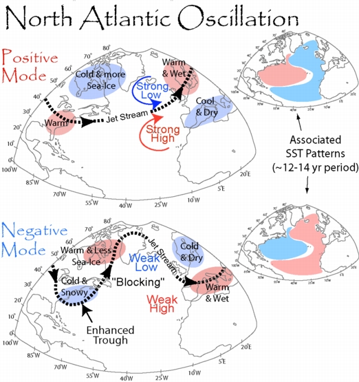
We're clearly in a +NAO which in turn =s a -AMO based on what I see in the above graphic but it also could lead to potential US landfalls so while it tends to be quieter there can still be some really bad systems like Andrew, Carmen, Hugo, Celia, Eloise, Frederic, Allen, and Elena
-AMO US landfalls since 1970 ts or higher
1970 Becky 40mph
1970 Celia 125mph
1970 Felice 70mph
1971 Doria 65mph
1971 Fern 70mph
1971 Edith 105mph
1971 Ginger 75mph
1971 Heidi 40mph
1972 Alpha 45mph
1972 Agnes 85mph
1973 Delia 70mph
1974 STS1 65mph
1974 Carmen 120mph
1975 Eloise 125mph
1976 STS1 50mph
1976 Belle 75mph
1976 Dottie 40mph
1976 STS3 45mph
1977 Babe 75mph
1978 Amelia 50mph
1978 Debra 60mph
1979 Bob 75mph
1979 Claudette 50mph
1979 David 105mph
1979 Frederic 135mph
1979 Elena 40mph
1980 Allen 115mph
1980 Danielle 60mph
1981 Dennis 50mph
1982 STS1 45mph
1982 Chris 65mph
1983 Alicia 115mph
1983 Barry 80mph
1983 Dean 55mph
1984 Diana 100mph
1984 Isidore 40mph
1985 Bob 75mph
1985 Danny 90mph
1985 Elena 120mph
1985 Gloria 105mph
1985 Henri 40mph
1985 Isabel 40mph
1985 Juan 75mph
1985 Kate 105mph
1986 Bonnie 85mph
1986 Charley 80mph
1987 TS2 45mph
1988 Beryl 50mph
1988 Chris 45mph
1988 Florence 80mph
1988 Keith 40mph
1989 Allison 50mph
1989 Chantal 80mph
1989 Hugo 140mph
1989 Jerry 85mph
1991 Bob 105mph
1992 Andrew 175mph
1992 Danielle 65mph
1993 Arlene 40mph
1994 Alberto 65mph
1994 Beryl 60mph
1994 Gordon 50mph
2014 Authur 100mph
Total: 62 storms
30 hurricanes
9 majors
PS: I put 2014 Arthur down because I do believe we are in a -AMO period which will probably last until 2030 or so
The posts in this forum are NOT official forecast and should not be used as such. They are just the opinion of the poster and may or may not be backed by sound meteorological data. They are NOT endorsed by any professional institution or storm2k.org. For official information, please refer to the NHC and NWS products
0 likes
-
CYCLONE MIKE
- Category 5
- Posts: 2183
- Joined: Tue Aug 31, 2004 6:04 pm
- Location: Gonzales, LA
Re: 2015 indicators: Instability / SST's / MSLP / Steering / Sal
Besides Arthur, which is in question but regardless look how far back one must go to find a land falling hurricane, over 20 yrs. So playing the odds chances are pretty slim to nill we have much to worry about especially the way this season is shaping up.
0 likes
-
Hypercane_Kyle

- Category 5
- Posts: 2899
- Joined: Sat Mar 07, 2015 7:58 pm
- Location: Cape Canaveral, FL
Re: 2015 indicators: Instability / SST's / MSLP / Steering / Sal
GOMEX SST anomalies are pretty high this year. I expect to see at least one tropical cyclone develop in the central GOMEX this year.*

*This is, of course, assuming wind shear is low enough and there's no dry air. Doesn't matter if it's an El Nino, La Nina, ENSO neutral, what have you -- SSTs in the GOMEX are always hot enough to support a storm of high magnitude by August.
*This is, of course, assuming wind shear is low enough and there's no dry air. Doesn't matter if it's an El Nino, La Nina, ENSO neutral, what have you -- SSTs in the GOMEX are always hot enough to support a storm of high magnitude by August.
0 likes
My posts are my own personal opinion, defer to the National Hurricane Center (NHC) and other NOAA products for decision making during hurricane season.
-
cycloneye
- Admin
- Posts: 139025
- Age: 67
- Joined: Thu Oct 10, 2002 10:54 am
- Location: San Juan, Puerto Rico
Re: 2015 indicators: Instability / SST's / MSLP / Steering / Sal
As March comes to an end shortly and April arrives the Instability is way down in the Tropical Atlantic and if that continues,it may be a dud MDR in 2015.
0 likes
Visit the Caribbean-Central America Weather Thread where you can find at first post web cams,radars
and observations from Caribbean basin members Click Here
and observations from Caribbean basin members Click Here
-
ninel conde
- Category 5
- Posts: 1245
- Joined: Mon Aug 04, 2008 2:18 pm
Re: 2015 indicators: Instability / SST's / MSLP / Steering / Sal
Hypercane_Kyle wrote:GOMEX SST anomalies are pretty high this year. I expect to see at least one tropical cyclone develop in the central GOMEX this year.*
*This is, of course, assuming wind shear is low enough and there's no dry air. Doesn't matter if it's an El Nino, La Nina, ENSO neutral, what have you -- SSTs in the GOMEX are always hot enough to support a storm of high magnitude by August.
very doubtful if the ripping wnw flow contines s it has the last many years now.
0 likes
The posts in this forum are NOT official forecast and should not be used as such. They are just the opinion of the poster and may or may not be backed by sound meteorological data. They are NOT endorsed by any professional institution or storm2k.org. For official information, please refer to the NHC and NWS products.

We also have to remember an "anomaly" doesn't actually do much. It's just a statistical figure compared to historical data, actual sea surface temperatures is what determines. A temperature in March may yield a completely different result in July. By August SST's will easily be warm enough basin-wide for sustained tropical activity even if the anomalies are cooler than normal.
What an anomaly can tell you is upper weather patterns, configuration of SST's relative to another region (think AMO/PDO etc). This is really important because the atmosphere often dictates whether it is conducive or not to allow storms. It can help hint at placement of ridges as troughs.
What an anomaly can tell you is upper weather patterns, configuration of SST's relative to another region (think AMO/PDO etc). This is really important because the atmosphere often dictates whether it is conducive or not to allow storms. It can help hint at placement of ridges as troughs.
0 likes
The above post and any post by Ntxw is NOT an official forecast and should not be used as such. It is just the opinion of the poster and may or may not be backed by sound meteorological data. It is NOT endorsed by any professional institution including Storm2k. For official information, please refer to NWS products.
Help support Storm2K!
-
Andrew92

- S2K Supporter

- Posts: 3247
- Age: 40
- Joined: Mon Jun 16, 2003 12:35 am
- Location: Phoenix, Arizona
The following post is NOT an official forecast and should not be used as such. It is just the opinion of the poster and may or may not be backed by sound meteorological data. It is NOT endorsed by any professional institution or storm2k.org. For official information, please refer to the NHC and NWS products.
I haven't studied the flow patterns as much as I probably should, but as quiet as it seems like this hurricane season might be, one thing concerns me. I brought up in a previous post some time ago that I think the Gulf of Mexico could be the place to watch for homegrown development, and my reason was pretty simple. It's just very difficult to go back-to-back years without a hurricane in that region, and last year was such a year.
But something else raised my eyebrows. I've looked at all the years since 1960 that did not feature a Gulf of Mexico hurricane, and nearly all of them had a major hurricane in that region the next year. Of those that did not, a major came the second year after. In only one probable instance since then have we gone back-to-back years without any hurricanes in the Gulf of Mexico: 1962 and 1963. HURDAT currently lists Cindy as a hurricane, but its pressure is quite high at 996 mb. I believe Sandy Delgado/HURAKAN worked on the 1963 season as part of his Master's thesis, and has downgraded Cindy to a tropical storm for now, and not added any other hurricanes in the Gulf that year. It's not official yet, but as I recall the thesis was recommended by higher-ups at the National Hurricane Center.
Here are the years without a Gulf of Mexico hurricane, followed in parentheses by majors that took place either the next year or second year after:
1962-63 (1962 definite, 1963 probable, but 1964 had Hilda)
1973 (Carmen in 1974)
1976 (Anita in 1977)
1978 (Frederic in 1979)
1981 (none in 1982, but Alicia in 1983 - one of the few instances of no major after a hurricane-free year in the Gulf)
1984 (Elena and Kate in 1985)
1991 (Andrew in 1992)
1994 (Opal in 1995)
2001 (Lili in 2002)
2006 (none in 2007, but Gustav and by pressure Ike in 2008)
2014 (to be determined)
Two years are awfully close. 1987 just barely had minimal Floyd in the far southeastern Gulf, though I suspect a downgrade as its pressure is about 995 mb and it was extremely disorganized for a hurricane. The other is 2011, when Nate barely qualified as a hurricane after-the-fact in the Bay of Campeche, for a mere few hours. For what it's worth, 1988 did see Gilbert, and though 2012 didn't have any majors in the Gulf, Isaac's pressure was very close to what is typical of a major.
There certainly seems to be a correlation for this, but I would have to research to find a specific cause, if there is one. I wouldn't use this as a complete predictor for what will take place in 2015. However, I would definitely be prepared and watchful this year for a strong hurricane in the Gulf of Mexico this year.
-Andrew92
0 likes
-
ninel conde
- Category 5
- Posts: 1245
- Joined: Mon Aug 04, 2008 2:18 pm
when was the last year there was an intensifying hurricane in the GOM north of 25n?
0 likes
The posts in this forum are NOT official forecast and should not be used as such. They are just the opinion of the poster and may or may not be backed by sound meteorological data. They are NOT endorsed by any professional institution or storm2k.org. For official information, please refer to the NHC and NWS products.
Who is online
Users browsing this forum: bird, Cpv17, Hybridstorm_November2001, Stormybajan and 98 guests