2015 indicators: Instability / SST's / MSLP / Steering / Sal

This is the general tropical discussion area. Anyone can take their shot at predicting a storms path.

Moderator: S2k Moderators

Forum rules

The posts in this forum are NOT official forecasts and should not be used as such. They are just the opinion of the poster and may or may not be backed by sound meteorological data. They are NOT endorsed by any professional institution or STORM2K. For official information, please refer to products from the National Hurricane Center and National Weather Service.

Help Support Storm2K
Message
Author
User avatar
WPBWeather
S2K Supporter
S2K Supporter
Posts: 535
Age: 65
Joined: Thu Jul 18, 2013 12:33 pm

Re:

#421 Postby WPBWeather » Sun Jul 12, 2015 11:56 am

ninel conde wrote:LC DOES NOT back down:

"While this is unlikely to be a big "Cape Verde" storm year, I still think that the Caribbean Sea, Gulf of Mexico, and Sargasso Sea will provide more action in the tropics than last year. My call for 14 named storms before November 31 remains. I also think that we may be in for an East Coast surprise in October."

if we arent allowed to quote him please delete.


LC may be correct.
0 likes   

User avatar
hurricanetrack
HurricaneTrack.com
HurricaneTrack.com
Posts: 1774
Joined: Tue Dec 02, 2003 10:46 pm
Location: Wilmington, NC
Contact:

#422 Postby hurricanetrack » Sun Jul 12, 2015 5:07 pm

I am looking forward to the extra day in November - THAT should be awesome! I think I will sleep that entire day and catch up on years of not sleeping like I should.

(had to, it was too easy)
0 likes   

User avatar
wxman57
Moderator-Pro Met
Moderator-Pro Met
Posts: 22480
Age: 66
Joined: Sat Jun 21, 2003 8:06 pm
Location: Houston, TX (southwest)

Re: Re:

#423 Postby wxman57 » Sun Jul 12, 2015 5:49 pm

WPBWeather wrote:
ninel conde wrote:LC DOES NOT back down:

"While this is unlikely to be a big "Cape Verde" storm year, I still think that the Caribbean Sea, Gulf of Mexico, and Sargasso Sea will provide more action in the tropics than last year. My call for 14 named storms before November 31 remains. I also think that we may be in for an East Coast surprise in October."

if we arent allowed to quote him please delete.


LC may be correct.


No one ever disagreed with him that the prime regions this season would be north of the Caribbean (like last season) and possibly in the Gulf of Mexico. However, there will be no 14 storms and ACE will likely end up below 50 (perhaps by a good bit). I've never seen the tropics as hostile as they are now and as they are predicted to be. There will certainly be no La Nina this season (did he predict that?).
0 likes   

User avatar
WPBWeather
S2K Supporter
S2K Supporter
Posts: 535
Age: 65
Joined: Thu Jul 18, 2013 12:33 pm

Re: Re:

#424 Postby WPBWeather » Sun Jul 12, 2015 6:57 pm

wxman57 wrote:
WPBWeather wrote:
ninel conde wrote:LC DOES NOT back down:

"While this is unlikely to be a big "Cape Verde" storm year, I still think that the Caribbean Sea, Gulf of Mexico, and Sargasso Sea will provide more action in the tropics than last year. My call for 14 named storms before November 31 remains. I also think that we may be in for an East Coast surprise in October."

if we arent allowed to quote him please delete.


LC may be correct.


No one ever disagreed with him that the prime regions this season would be north of the Caribbean (like last season) and possibly in the Gulf of Mexico. However, there will be no 14 storms and ACE will likely end up below 50 (perhaps by a good bit). I've never seen the tropics as hostile as they are now and as they are predicted to be. There will certainly be no La Nina this season (did he predict that?).


You may be correct Wxman57. The lagging shear indicators that you and some others have listed are spot on. The leading indicator predictions may also be correct, but time will tell. I am always leery of anyone who is in the storm numbers prediction game--a fool's errand IMO.
0 likes   

User avatar
gatorcane
S2K Supporter
S2K Supporter
Posts: 23499
Age: 46
Joined: Sun Mar 13, 2005 3:54 pm
Location: Boca Raton, FL

#425 Postby gatorcane » Sun Jul 12, 2015 9:47 pm

Yeah conditions are horrible out there no doubt even for July standards, but one thing that continues to be different from the past many, many seasons is how strong this Bermuda High is. This high has lead to extreme drought conditions along the SE Coast of Florida.

Also, we could be dealing with a strong Bermuda High come Aug-Sept given how persistent it has been the past several months. If just one system has that window of opportunity and get underneath that High even if it comes out of the MDR a sheared mess, it could be interesting especially since many of us are forecasting good conditions just north of the Caribbean.

NWS Miami snippet mentions the Bermuda High. If FINALLY is going to weaken temporarily providing South Florida with some of the best rain chances in weeks. But later on this week the High builds in once again where east flow will return. Seriously this east wind pattern is a broken record.

THE BERMUDA HIGH, THAT HAS KEPT THE EASTERLY FLOW OVER SOUTH
FLORIDA WILL BEGIN TO WEAKEN OVER THE NEXT SEVERAL DAYS. FOR
TODAY, THE EAST FLOW WILL BE ABLE TO HOLD ON, KEEPING THE THREAT
FOR SHOWERS AND THUNDERSTORMS BASICALLY IN THE SAME AREA THEY
HAVE BEEN IMPACTING FOR THE LAST WEEK OR SO. PWATS WILL BE ON THE
DRY SIDE FOR MUCH OF THE AREA

http://forecast.weather.gov/product.php ... glossary=1
0 likes   

User avatar
South Texas Storms
Professional-Met
Professional-Met
Posts: 4002
Joined: Thu Jun 24, 2010 12:28 am
Location: Houston, TX

Re: Re:

#426 Postby South Texas Storms » Sun Jul 12, 2015 11:15 pm

wxman57 wrote:
WPBWeather wrote:
ninel conde wrote:LC DOES NOT back down:

"While this is unlikely to be a big "Cape Verde" storm year, I still think that the Caribbean Sea, Gulf of Mexico, and Sargasso Sea will provide more action in the tropics than last year. My call for 14 named storms before November 31 remains. I also think that we may be in for an East Coast surprise in October."

if we arent allowed to quote him please delete.


LC may be correct.


No one ever disagreed with him that the prime regions this season would be north of the Caribbean (like last season) and possibly in the Gulf of Mexico. However, there will be no 14 storms and ACE will likely end up below 50 (perhaps by a good bit). I've never seen the tropics as hostile as they are now and as they are predicted to be. There will certainly be no La Nina this season (did he predict that?).


He has been consistently predicting a La Nina event for this winter over the past several months, but he has recently changed his forecast to an El Nino event (as one is already occurring). However I think he is now forecasting this El Nino event to weaken to Neutral by January 2016, which I do not think will verify.
0 likes   

User avatar
Steve
S2K Supporter
S2K Supporter
Posts: 8605
Joined: Sat Apr 05, 2003 11:41 pm
Location: Not a state-caster

Re: Re:

#427 Postby Steve » Mon Jul 13, 2015 1:03 pm

...However, there will be no 14 storms and ACE will likely end up below 50 (perhaps by a good bit)...


I agree with you on his numbers which could be double-high, but it's a tough call on the ACE. With the idea that the Western Atlantic (Bahamas and North of there) could harbor some potentially strong, slower moving systems, you could get one or more piling up ACE. I think the Atlantic record was 1899 with maybe slightly above 73? So theoretically, a 4 or a 5 could be in the Atlantic and be at least a Cat 1 for several days and change the dynamic of the ACE for the season. Same thing with a Fall Caribbean system were the El Nino to back off a little earlier or should there be an interruption in the winds down in the Western Caribbean or Southern Gulf. IMHO, ACE could be below 50 (perhaps by a good bit) or it could exceed by 20-30 points as well. Tough, tough call IMHO.
Last edited by Steve on Wed Jul 15, 2015 10:02 pm, edited 1 time in total.
0 likes   

User avatar
Andrew92
S2K Supporter
S2K Supporter
Posts: 3247
Age: 40
Joined: Mon Jun 16, 2003 12:35 am
Location: Phoenix, Arizona

#428 Postby Andrew92 » Wed Jul 15, 2015 7:44 pm

The following post is NOT an official forecast and should not be used as such. It is just the opinion of the poster and may or may not be backed by sound meteorological data. It is NOT endorsed by any professional institution or storm2k.org. For official information, please refer to the NHC and NWS products.

Well, we have had the kind of storm that has been commonplace in traditional El Nino events in recent years: one that forms from a frontal low off the East Coast in the middle part of July, heads quickly out to sea lasting only a couple days or so, and isn't very strong. 1997 had three of these (although Bill was a hurricane), 2002 had Arthur (was a Modoki, but had warmish anomalies in the eastern Pacific too, which may have acted to sort of act like traditional), and 2006 had an unnamed storm and Beryl.

It's still a little hard to say what exactly the peak of the season might be like except that the MDR and Caribbean will likely be inactive due to the influence on El Nino. But what might happen over the next month as we get ready for the peak, say between now and August 15?

History is often the best teacher, and if 1997, 2002 (Modoki or not), and 2006 are any indication, the Atlantic probably won't see much between now and August 15. 1997 still had Danny to come for the Gulf Coast and a brief East Coast threat later, 2002 would have short-lived storms Bertha and Cristobal in early August, and after the unnamed storm and Beryl, there was Chris just north of the Caribbean in 2006. Of course, the 2006 storms hadn't happened yet, and with both being off the East Coast, plus later Danny and Cristobal, I wouldn't rule out another weak storm in that area between now and that date. Other examples of activity off the East Coast in El Nino years between now and August 15 include Dolly in 1968, Belle in 1976, and Arlene in 1987. All of those storms were hurricanes, but the El Ninos in 1968 and 1976 were weaker than this year's (and Dolly was a Category 1), and Arlene took a long time to finally become barely a hurricane far out to the east, so I have doubts we will see a hurricane in that area this year.

What about the Gulf of Mexico, the area I think could be a place to watch? I mean, Danny in 1997 hadn't formed just yet and Bertha in 2002 was still to come. A look back at other El Ninos shows Bertha in 1957, an unnamed storm in 1987, and Beryl in 1994 also developed in this period in that region. Only Danny was a hurricane, because it sat over the water longer than all the others did. This El Nino probably won't get as strong as 1997, but that doesn't really improve the chances for seeing a hurricane by August 15 in this part of the Atlantic. Hurting chances is that the Gulf of Mexico at this time is quite unfavorable with 25-30 knots of shear, though that can change during these next 30 or so days.

Further, the majors in the Gulf of Mexico in El Ninos have included Audrey in 1957, Betsy in 1965, Anita in 1977, Isidore in 2002, and Lili in 2002. Of these, only Audrey had taken place by now. Therefore, just because I'm not calling for a big storm in the Gulf of Mexico during these next 30 days or so, or even a hurricane, doesn't mean it won't happen closer to the peak, a much more likely period. The fact remains that no hurricanes took place in the Gulf last year, and that is usually followed by a season with at least one major, even if the year is El Nino. 1977 as such might be a great analog for this season, given the strength of this event, though I suspect we will have significantly more EPAC activity than that year.

-Andrew92
Last edited by tolakram on Wed Jul 15, 2015 9:02 pm, edited 1 time in total.
Reason: fixed tags
0 likes   

User avatar
galaxy401
Category 5
Category 5
Posts: 2298
Age: 28
Joined: Sat Aug 25, 2012 9:04 pm
Location: Casa Grande, Arizona

#429 Postby galaxy401 » Thu Jul 16, 2015 4:55 pm

Since it looks like the Caribbean will be a graveyard like the last two seasons and Claudette coming out of nowhere off the east coast I think this season will be similar to 2011. Not in terms of number of named storms but that most formations will be in the subtropical latitudes.

The following post is NOT an official forecast and should not be used as such. It is just the opinion of the poster and may or may not be backed by sound meteorological data. It is NOT endorsed by any professional institution or storm2k.org. For official information, please refer to the NHC and NWS products.
0 likes   
Got my eyes on moving right into Hurricane Alley: Florida.

User avatar
gatorcane
S2K Supporter
S2K Supporter
Posts: 23499
Age: 46
Joined: Sun Mar 13, 2005 3:54 pm
Location: Boca Raton, FL

#430 Postby gatorcane » Fri Jul 17, 2015 3:52 pm

93L may suggest the MDR could be more moist this year than previous years once we reach Aug-Sept. 93L had a huge convection area yesterday and it is only mid July. GFS and ECMWF models continue to show another vigorous wave to emerge from the African coast in about one week (see Global Models thread). If anything, these waves are sacrificial waves that could continue to moisten the MDR once conditions improve out there in about 4 weeks. We will need to watch these waves especially the waves that manage to get into the area just north of the Leewards/Caribbean with sufficient convection/spin remaining.
0 likes   

User avatar
TheStormExpert
Category 5
Category 5
Posts: 8487
Age: 30
Joined: Wed Feb 16, 2011 5:38 pm
Location: Palm Beach Gardens, FL

Re:

#431 Postby TheStormExpert » Fri Jul 17, 2015 8:42 pm

gatorcane wrote:93L may suggest the MDR could be more moist this year than previous years once we reach Aug-Sept. 93L had a huge convection area yesterday and it is only mid July. GFS and ECMWF models continue to show another vigorous wave to emerge from the African coast in about one week (see Global Models thread). If anything, these waves are sacrificial waves that could continue to moisten the MDR once conditions improve out there in about 4 weeks. We will need to watch these waves especially the waves that manage to get into the area just north of the Leewards/Caribbean with sufficient convection/spin remaining.

These same words were said last year and the year before by MANY and look what happened in the MDR...nothing basically. Just like pre-season storms and early season hurricanes it is NOT IMO a indicator of what may happen or what conditions may be like.

IMHO nothing will change or improve within the next month or two.
0 likes   
The following post is NOT an official forecast and should not be used as such. It is just the opinion of the poster and may or may not be backed by sound meteorological data. It is NOT endorsed by storm2k.org.

tolakram
Admin
Admin
Posts: 19165
Age: 60
Joined: Sun Aug 27, 2006 8:23 pm
Location: Florence, KY (name is Mark)

Re: 2015 indicators: Instability / SST's / MSLP / Steering / Sal

#432 Postby tolakram » Fri Jul 17, 2015 10:17 pm

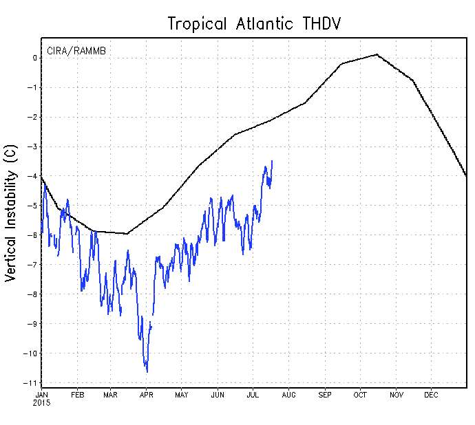
Some saved images.

Tropical Atlantic Instability
Image

Tropical Atlantic Shear
Image

Another look at the same thing, basin wide relative to normal.

Instability
Image

Shear
Image
0 likes   
M a r k
- - - - -
Join us in chat: Storm2K Chatroom Invite. Android and IOS apps also available.

The posts in this forum are NOT official forecasts and should not be used as such. Posts are NOT endorsed by any professional institution or STORM2K.org. For official information and forecasts, please refer to NHC and NWS products.

User avatar
gatorcane
S2K Supporter
S2K Supporter
Posts: 23499
Age: 46
Joined: Sun Mar 13, 2005 3:54 pm
Location: Boca Raton, FL

#433 Postby gatorcane » Sat Jul 18, 2015 9:27 am

Thanks Mark for the above images. As you can see we are just about normal now as far as shear and instability for July but July is not a climatologically favored month for TCs across the Atlantic (especially the first half of July) so the hostile conditions out there should not be a surprise! Still have some ground to make up on instability but not too far from normal.

Getting close to kick-off of the "real" Atlantic hurricane season which kicks off Aug 1st and runs through most of October. I can't stress enough how important it is not let your guard down just because of "el nino." It is no guarantee!

Image
0 likes   

User avatar
Yellow Evan
Professional-Met
Professional-Met
Posts: 15951
Age: 25
Joined: Fri Jul 15, 2011 12:48 pm
Location: Henderson, Nevada/Honolulu, HI
Contact:

Re:

#434 Postby Yellow Evan » Sat Jul 18, 2015 10:38 am

gatorcane wrote:93L may suggest the MDR could be more moist this year than previous years once we reach Aug-Sept. 93L had a huge convection area yesterday and it is only mid July. GFS and ECMWF models continue to show another vigorous wave to emerge from the African coast in about one week (see Global Models thread). If anything, these waves are sacrificial waves that could continue to moisten the MDR once conditions improve out there in about 4 weeks. We will need to watch these waves especially the waves that manage to get into the area just north of the Leewards/Caribbean with sufficient convection/spin remaining.


It suggests the MDR will moisten somewhat when we get a good MJO/KW pulse. That's all.
0 likes   

CrazyC83
Professional-Met
Professional-Met
Posts: 33393
Joined: Tue Mar 07, 2006 11:57 pm
Location: Deep South, for the first time!

#435 Postby CrazyC83 » Sat Jul 18, 2015 6:24 pm

There's another front emerging off the east coast this week? I would watch that. So far all three storms have originated from non-tropical sources, so those would be what to watch. Stalled fronts, troughs and MCS's all have that potential. A storm like Hurricane Bob (1991) wouldn't be impossible later in the season either.

Agreed the Gulf of Mexico could produce some late (for the Gulf) season surprises.
0 likes   

User avatar
wxman57
Moderator-Pro Met
Moderator-Pro Met
Posts: 22480
Age: 66
Joined: Sat Jun 21, 2003 8:06 pm
Location: Houston, TX (southwest)

Re: 2015 indicators: Instability / SST's / MSLP / Steering / Sal

#436 Postby wxman57 » Sat Jul 18, 2015 8:26 pm

I think 93L is a sign that the MDR is going to suffocate and shear systems apart. Look north of the MDR and in the Gulf for development.
0 likes   

CrazyC83
Professional-Met
Professional-Met
Posts: 33393
Joined: Tue Mar 07, 2006 11:57 pm
Location: Deep South, for the first time!

#437 Postby CrazyC83 » Sat Jul 18, 2015 8:44 pm

Not sure if the details are available, but what allowed Hurricane Erika in 1997 to develop and reach major hurricane intensity in the low latitudes? Other than that storm, 1997 was dead in the deep tropics.
0 likes   

User avatar
Yellow Evan
Professional-Met
Professional-Met
Posts: 15951
Age: 25
Joined: Fri Jul 15, 2011 12:48 pm
Location: Henderson, Nevada/Honolulu, HI
Contact:

#438 Postby Yellow Evan » Sat Jul 18, 2015 8:46 pm

If I had to guess, Erika had a decent MJO/KW pulse.

You get those in El Nino years.
0 likes   

Ntxw
Storm2k Moderator
Storm2k Moderator
Posts: 21491
Joined: Wed Oct 21, 2009 6:34 pm
Location: DFW, Texas

Re:

#439 Postby Ntxw » Sat Jul 18, 2015 9:12 pm

Yellow Evan wrote:If I had to guess, Erika had a decent MJO/KW pulse.

You get those in El Nino years.


I checked archives from BOM's MJO phases, it was mostly incoherent. My guess is it just found a small window in the most climo favored time in mid September and made the most of it. Erika collected over half of 1997's ACE. If not for that system, the season would've fit right in with 1982 and 1972 super Nino's around 26-29 ACE. In a sense quite similar to what Gonzalo did last year racking up a majority of the ACE in 2014 in one storm. Both in similar fashion cranking once missing the Caribbean and past 20N
0 likes   
The above post and any post by Ntxw is NOT an official forecast and should not be used as such. It is just the opinion of the poster and may or may not be backed by sound meteorological data. It is NOT endorsed by any professional institution including Storm2k. For official information, please refer to NWS products.

  Help support Storm2K!
Help Support Storm2K

Alyono
Professional-Met
Professional-Met
Posts: 6961
Joined: Fri Apr 26, 2013 3:52 pm
Location: Texas Coast

Re:

#440 Postby Alyono » Sat Jul 18, 2015 9:59 pm

CrazyC83 wrote:Not sure if the details are available, but what allowed Hurricane Erika in 1997 to develop and reach major hurricane intensity in the low latitudes? Other than that storm, 1997 was dead in the deep tropics.


Erika really intensified northeast of the Caribbean. It also struggled in the deep tropics
0 likes   


Return to “Talkin' Tropics”

Who is online

Users browsing this forum: Cpv17, Orlando_wx, SFLcane, zzzh and 48 guests