Area of Disturbed Weather in the NW Caribbean
Moderator: S2k Moderators
Forum rules

The posts in this forum are NOT official forecasts and should not be used as such. They are just the opinion of the poster and may or may not be backed by sound meteorological data. They are NOT endorsed by any professional institution or STORM2K. For official information, please refer to products from the National Hurricane Center and National Weather Service.
-
gatorcane

- S2K Supporter

- Posts: 23499
- Age: 46
- Joined: Sun Mar 13, 2005 3:54 pm
- Location: Boca Raton, FL
Area of Disturbed Weather in the NW Caribbean
We now have an incipient area if disturbed weather that has developed on the northern axis of a tropical wave traversing the Eastern Caribbean sea this evening. Global models are showing some possible development either in the NW Caribbean or around Florida next week as a trough of low pressure forms. Latest GFS model is showing an even more concentrated area of storms building in the NW Caribbean in few days from this area of disturbed weather.
Last edited by gatorcane on Mon Jun 01, 2015 12:02 pm, edited 1 time in total.
0 likes

Re: Area of Disturbed Weather in Caribbean
If this low does form and moves across South Florida it will be very beneficial since the month of May has been dry. The eastern side of Florida has been unusually dry because of the nonstop easterly flow so maybe a welcome pattern change will happen.
0 likes

Re: Area of Disturbed Weather in Caribbean
This tropical wave will have one tough UL environment to deal with if a closed surface low pressure forms from the NW Caribbean, SE GOM and NW Atlantic with a forecasted ULL parks itself over the northern gulf coast.
Regardless much need rains will come to SE FL and eastern central FL.
The posts in this forum are NOT official forecast and should not be used as such. They are just the opinion of the poster and may or may not be backed by sound meteorological data. They are NOT endorsed by any professional institution or storm2k.org. For official information, please refer to the NHC and NWS products.
0 likes
-
TheStormExpert

- Category 5

- Posts: 8487
- Age: 30
- Joined: Wed Feb 16, 2011 5:38 pm
- Location: Palm Beach Gardens, FL
Re: Area of Disturbed Weather in Caribbean
NDG wrote:This tropical wave will have one tough UL environment to deal with if a closed surface low pressure forms from the NW Caribbean, SE GOM and NW Atlantic with a forecasted ULL parks itself over the northern gulf coast.
Regardless much need rains will come to SE FL and eastern central FL.
The posts in this forum are NOT official forecast and should not be used as such. They are just the opinion of the poster and may or may not be backed by sound meteorological data. They are NOT endorsed by any professional institution or storm2k.org. For official information, please refer to the NHC and NWS products.
How much rain do you see possibly affecting us here? Where I live we could desperately use the rainfall, because I feel that this rainy season could be the driest in years for folks in SE Florida or all of the East Coast of Florida.
0 likes
The following post is NOT an official forecast and should not be used as such. It is just the opinion of the poster and may or may not be backed by sound meteorological data. It is NOT endorsed by storm2k.org.
-
Hurricane Alexis

- Category 2

- Posts: 683
- Age: 27
- Joined: Thu Jun 14, 2012 7:59 pm
- Location: Miami,Florida
Re: Area of Disturbed Weather in Caribbean
GFs trending stronger on this run. 1004 mb low making landfall on SW Florida.
0 likes
Personal Forecast Disclaimer:
The posts in this forum are NOT official forecast and should not be used as such. They are just the opinion of the poster and may or may not be backed by sound meteorological data. They are NOT endorsed by any professional institution or storm2k.org. For official information, please refer to the NHC and NWS products.
The posts in this forum are NOT official forecast and should not be used as such. They are just the opinion of the poster and may or may not be backed by sound meteorological data. They are NOT endorsed by any professional institution or storm2k.org. For official information, please refer to the NHC and NWS products.
-
northjaxpro

- S2K Supporter
- Posts: 8900
- Joined: Mon Sep 27, 2010 11:21 am
- Location: Jacksonville, FL
Yeah, we definitely need the rain as boca pointed out above. This has been one of the driest start to the supposed rainy season I have seen in recent memory here and all along the Florida East Coast. This persistent easterly flow has continued now for much of May and not only has it kept the eastern side of the state dry, it has caused major problems with rip currents which unfortunately has lead to some people losing their lives in drownings a long the coast, especially over the long Memorial holiday weekend.
This disturbance will have the potential to finally change this pattetn and bring the peninsula some much needed rain by the mid-late portions of next week. Deep tropical moisture hopefully will move north and a weak Low may form late next week. NDG is spot on regarding upper level conditions and the models have moderate to strong shear levels forecast across the GOM the latter half of next week. If any Low does try to spin-up, it will probably be a lopsided, sheared system.
This disturbance will have the potential to finally change this pattetn and bring the peninsula some much needed rain by the mid-late portions of next week. Deep tropical moisture hopefully will move north and a weak Low may form late next week. NDG is spot on regarding upper level conditions and the models have moderate to strong shear levels forecast across the GOM the latter half of next week. If any Low does try to spin-up, it will probably be a lopsided, sheared system.
0 likes
NEVER, EVER SAY NEVER in the tropics and weather in general, and most importantly, with life itself!!
________________________________________________________________________________________
Fay 2008 Beryl 2012 Debby 2012 Colin 2016 Hermine 2016 Julia 2016 Matthew 2016 Irma 2017 Dorian 2019
________________________________________________________________________________________
Fay 2008 Beryl 2012 Debby 2012 Colin 2016 Hermine 2016 Julia 2016 Matthew 2016 Irma 2017 Dorian 2019
Re: Area of Disturbed Weather in Caribbean
TheStormExpert wrote:NDG wrote:This tropical wave will have one tough UL environment to deal with if a closed surface low pressure forms from the NW Caribbean, SE GOM and NW Atlantic with a forecasted ULL parks itself over the northern gulf coast.
Regardless much need rains will come to SE FL and eastern central FL.
The posts in this forum are NOT official forecast and should not be used as such. They are just the opinion of the poster and may or may not be backed by sound meteorological data. They are NOT endorsed by any professional institution or storm2k.org. For official information, please refer to the NHC and NWS products.
How much rain do you see possibly affecting us here? Where I live we could desperately use the rainfall, because I feel that this rainy season could be the driest in years for folks in SE Florida or all of the East Coast of Florida.
The GFS has been indicating 3-10" for at least southern FLORIDA with the 0z run taking it all the way into NE FL.
This is how dry most of the state has been during the month of May, for the exception of the immediate west coast, even southern GA could use some rain from this wave.

0 likes
-
floridasun78
- Category 5
- Posts: 3755
- Joined: Sun May 17, 2009 10:16 pm
- Location: miami fl
 this lasterst one
-
floridasun78
- Category 5
- Posts: 3755
- Joined: Sun May 17, 2009 10:16 pm
- Location: miami fl
here link to gfs show low in nw carribbean by june 3 http://www.tropicaltidbits.com/analysis ... 0&ypos=406
0 likes

Re: Area of Disturbed Weather in Caribbean
It's really not looking promising as far as being tropical at this point, but more like an elongated frontal low after it passes Cuba.
0 likes
The above post is not official and should not be used as such. It is the opinion of the poster and may or may not be backed by sound meteorological data. It is not endorsed by any professional institution or storm2k.org. For official information, please refer to the NHC and NWS products.
-
gatorcane
- S2K Supporter
- Posts: 23499
- Age: 46
- Joined: Sun Mar 13, 2005 3:54 pm
- Location: Boca Raton, FL
Latest IR loop below. Just a widespread area of disorganized showers and some storms, nothing organized. The tropical wave is in the Central Caribbean and will continue to move west over the next several days. If anything does form next week, we will need to wait until the trough pushing east over the Central United States amplifies and digs into the Gulf shifting the winds across the Western Caribbean from WNW to SW as an upper ridge tries to develop over the Central-Western Caribbean. Shear looks like it will remain high across the NW Caribbean and Florida and still looks to be the main factor that will inhibit any significant development. Still the GFS is trying to close off a low with varying degrees of intensity with the 00Z run showing a full-blown tropical storm into South Florida but a weak low feature in the 06Z and 12Z runs since. The 12Z ECMWF doesn't show anything closing off.

0 likes
Re: Area of Disturbed Weather in Caribbean
Im hoping this low develops but honestly I dont see it happening because of wind shear blowing rapidly off to the east. I hope Im wrong.
0 likes
The formation of a coherent tropical (or even subtropical) low, while possible, is not the most likely scenario from this...early season, high shear, marginal OHC, we know the drill. what is worth paying attention to as far as sensible wx for Florida folks is the growing potential for deep tropical moisture to overspread the peninsula and dump (in many cases) much needed heavy rain, a welcome diversion from the sterile May most of the peninsula just experienced. I think anything beyond that is an extreme long shot. nevertheless, the potential for PWATS north of 2" and a lifting mechanism should intrigue anyone with a weather interest. I am certainly watching.
0 likes
-
jlauderdal
- S2K Supporter
- Posts: 6771
- Joined: Wed May 19, 2004 5:46 am
- Location: NE Fort Lauderdale
- Contact:
Re:
psyclone wrote:The formation of a coherent tropical (or even subtropical) low, while possible, is not the most likely scenario from this...early season, high shear, marginal OHC, we know the drill. what is worth paying attention to as far as sensible wx for Florida folks is the growing potential for deep tropical moisture to overspread the peninsula and dump (in many cases) much needed heavy rain, a welcome diversion from the sterile May most of the peninsula just experienced. I think anything beyond that is an extreme long shot. nevertheless, the potential for PWATS north of 2" and a lifting mechanism should intrigue anyone with a weather interest. I am certainly watching.
June is average wettest month in Sofla so heavy rain to be expected...we need rain on the east coast
0 likes
Re: Area of Disturbed Weather in Caribbean
Its bone dry here in SE Florida so Im rooting on this to happen.
0 likes
-
gatorcane
- S2K Supporter
- Posts: 23499
- Age: 46
- Joined: Sun Mar 13, 2005 3:54 pm
- Location: Boca Raton, FL
I am watching the 18Z GFS run coming in right now. It still continues to close off a low along the tropical wave in the Central Caribbean as it passes NE over South Florida from the NW Caribbean, but the shear keeps it from developing into anything significant, thankfully.
The closed low starts to develop in the NW Caribbean in about 3-4 days from now.

The closed low starts to develop in the NW Caribbean in about 3-4 days from now.
0 likes
-
tropicwatch

- Category 5
- Posts: 3205
- Age: 60
- Joined: Sat Jun 02, 2007 10:01 am
- Location: Panama City Florida
- Contact:
Hope it makes it into the GOM before it makes an eastward trek. NW Fl, especially around Panama City along the coast could use the rain. I had some short showers Wednesday and Thursday but that has been it for the whole month:(
0 likes
Tropicwatch
Agnes 72', Eloise 75, Elena 85', Kate 85', Charley 86', Florence 88', Beryl 94', Dean 95', Erin 95', Opal 95', Earl 98', Georges 98', Ivan 2004', Arlene 2005', Dennis 2005', Ida 2009' Debby 2012' Irma 2017' Michael 2018'
Agnes 72', Eloise 75, Elena 85', Kate 85', Charley 86', Florence 88', Beryl 94', Dean 95', Erin 95', Opal 95', Earl 98', Georges 98', Ivan 2004', Arlene 2005', Dennis 2005', Ida 2009' Debby 2012' Irma 2017' Michael 2018'

-
floridasun78
- Category 5
- Posts: 3755
- Joined: Sun May 17, 2009 10:16 pm
- Location: miami fl
Re: Area of Disturbed Weather in Caribbean
this how rain we get by next Friday 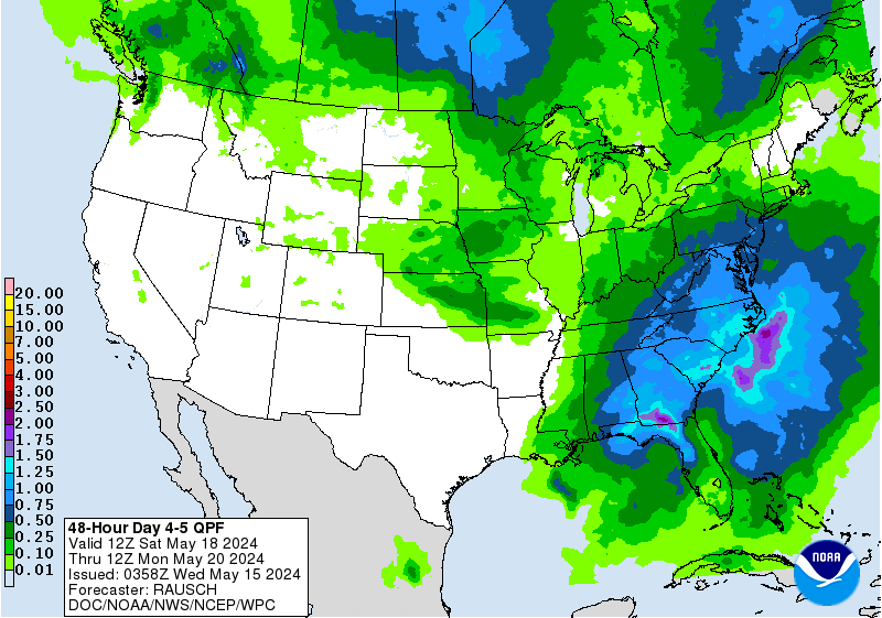 here web site http://www.wpc.ncep.noaa.gov/qpf/day4-7.shtml
here web site http://www.wpc.ncep.noaa.gov/qpf/day4-7.shtml
0 likes
Who is online
Users browsing this forum: Stormybajan, zzzh and 191 guests