Development off SE U.S coast?
Moderator: S2k Moderators
Forum rules
The posts in this forum are NOT official forecasts and should not be used as such. They are just the opinion of the poster and may or may not be backed by sound meteorological data. They are NOT endorsed by any professional institution or STORM2K. For official information, please refer to products from the National Hurricane Center and National Weather Service.
- northjaxpro
- S2K Supporter

- Posts: 8900
- Joined: Mon Sep 27, 2010 11:21 am
- Location: Jacksonville, FL
0 likes
NEVER, EVER SAY NEVER in the tropics and weather in general, and most importantly, with life itself!!
________________________________________________________________________________________
Fay 2008 Beryl 2012 Debby 2012 Colin 2016 Hermine 2016 Julia 2016 Matthew 2016 Irma 2017 Dorian 2019
________________________________________________________________________________________
Fay 2008 Beryl 2012 Debby 2012 Colin 2016 Hermine 2016 Julia 2016 Matthew 2016 Irma 2017 Dorian 2019
- northjaxpro
- S2K Supporter

- Posts: 8900
- Joined: Mon Sep 27, 2010 11:21 am
- Location: Jacksonville, FL
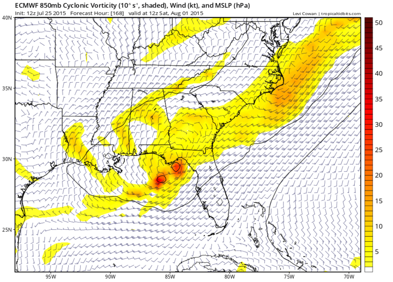
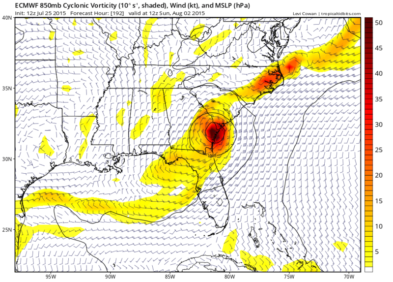
Also, interesting to see EURO come around to the CMC and what that model as showing the past couple of days of Low pressure forming in the NE GOM.
CMC may deserve kudos when it is all said and done. We shall see.
CMC may deserve kudos when it is all said and done. We shall see.
0 likes
NEVER, EVER SAY NEVER in the tropics and weather in general, and most importantly, with life itself!!
________________________________________________________________________________________
Fay 2008 Beryl 2012 Debby 2012 Colin 2016 Hermine 2016 Julia 2016 Matthew 2016 Irma 2017 Dorian 2019
________________________________________________________________________________________
Fay 2008 Beryl 2012 Debby 2012 Colin 2016 Hermine 2016 Julia 2016 Matthew 2016 Irma 2017 Dorian 2019
Meanwhile I am in St Augustine today, trough came through this area, nice NE winds in this part of FL, this change in wind direction should help in ending the ongoing upwelling that has present for the past couple weeks, happy beach goers today.
0 likes
- northjaxpro
- S2K Supporter

- Posts: 8900
- Joined: Mon Sep 27, 2010 11:21 am
- Location: Jacksonville, FL
and NDG you are in my neck of the woods today yes those north east winds feel nice today Definitely can tell the trough axis has shifted to the south of NE Fl.
0 likes
NEVER, EVER SAY NEVER in the tropics and weather in general, and most importantly, with life itself!!
________________________________________________________________________________________
Fay 2008 Beryl 2012 Debby 2012 Colin 2016 Hermine 2016 Julia 2016 Matthew 2016 Irma 2017 Dorian 2019
________________________________________________________________________________________
Fay 2008 Beryl 2012 Debby 2012 Colin 2016 Hermine 2016 Julia 2016 Matthew 2016 Irma 2017 Dorian 2019
Re:
northjaxpro wrote:Also, interesting to see EURO come around to the CMC and what that model as showing the past couple of days of Low pressure forming in the NE GOM.
CMC may deserve kudos when it is all said and done. We shall see.
I don't think any of the models really have any idea at this point, the Euro/CMC swapped places last night, now the Euro is currently going inbetween where we each thought it would go yesterday, the CMC is dissolving it into a trough, and now the GFS is showing essentially what CMC showed yesterday. It's almost becoming a case of throw a dart and see where it goes.
0 likes
The above post is not official and should not be used as such. It is the opinion of the poster and may or may not be backed by sound meteorological data. It is not endorsed by any professional institution or storm2k.org. For official information, please refer to the NHC and NWS products.
- northjaxpro
- S2K Supporter

- Posts: 8900
- Joined: Mon Sep 27, 2010 11:21 am
- Location: Jacksonville, FL
x
yeah Hammy it is a general mess with the models but I'm going to give the CMC credit if we do get development in the NE Gulf of Mexico in the next few days. That model consistently initialized potential development there the past couple of days.
Last edited by northjaxpro on Sat Jul 25, 2015 3:12 pm, edited 1 time in total.
0 likes
NEVER, EVER SAY NEVER in the tropics and weather in general, and most importantly, with life itself!!
________________________________________________________________________________________
Fay 2008 Beryl 2012 Debby 2012 Colin 2016 Hermine 2016 Julia 2016 Matthew 2016 Irma 2017 Dorian 2019
________________________________________________________________________________________
Fay 2008 Beryl 2012 Debby 2012 Colin 2016 Hermine 2016 Julia 2016 Matthew 2016 Irma 2017 Dorian 2019
-
NCSTORMMAN
I'm beginning to think nothing is going to develop at all out of this, after days of consistency the models are now all pushing development back with each run.
0 likes
The above post is not official and should not be used as such. It is the opinion of the poster and may or may not be backed by sound meteorological data. It is not endorsed by any professional institution or storm2k.org. For official information, please refer to the NHC and NWS products.
- HurricaneBelle
- S2K Supporter

- Posts: 974
- Joined: Sun Aug 27, 2006 6:12 pm
- Location: Clearwater, FL
Re:
NCSTORMMAN wrote:Anyone else see what looks like spin in the northeast Gulf of Mexico near Florida? Or am I just seeing things?
Not just you. NWS Tampa Bay notes in their AFD from about an hour ago:
LOOKING AT THE WIND AND SURFACE PRESSURE OBSERVATIONS...
ONE CAN IMAGINE A VERY WEAK AREA OF LOW PRESSURE LOCATED
SOMEWHERE OVER THE FLORIDA BIG BEND AREA...NEAR
CROSS CITY OR CHIEFLAND.
That low pressure may be tracking toward Jacksonville as now it appears a squall line has formed that is moving SW through North Florida, whereas all the weather over the state the last couple of days including this morning had been moving SE.
0 likes
Re:
Hammy wrote:I'm beginning to think nothing is going to develop at all out of this, after days of consistency the models are now all pushing development back with each run.
Models always tend to forecast development quicker than what it actually happens.
0 likes
- gatorcane
- S2K Supporter

- Posts: 23499
- Age: 46
- Joined: Sun Mar 13, 2005 3:54 pm
- Location: Boca Raton, FL
well one thing is for sure. The models have trended more towards the Eastern Gulf and away from a system forming off the SE US coast. The ECMWF, UKMET, and GFS are showing a Gulf low with the UKMET (usually a conservative model) the most bullish developing 1001MB tropical storm that impacts New Orleans at 144 hours.
Last edited by gatorcane on Sat Jul 25, 2015 4:51 pm, edited 2 times in total.
0 likes
-
floridasun78
- Category 5

- Posts: 3755
- Joined: Sun May 17, 2009 10:16 pm
- Location: miami fl
Re: Development off SE U.S coast?
i see storms increasing in eastern gulf today here in south fl we getting rain this afternoon maybe what Model were picking up
0 likes
So basically the models have skidded everybody from Atlantic Canada to Florida and now New Orleans , next will be Tx 
Lots of rain for FL though thats certain. Lowering pressures and splitting/moving of heat ridges giving models fits.
Lots of rain for FL though thats certain. Lowering pressures and splitting/moving of heat ridges giving models fits.
0 likes
The above post and any post by Ntxw is NOT an official forecast and should not be used as such. It is just the opinion of the poster and may or may not be backed by sound meteorological data. It is NOT endorsed by any professional institution including Storm2k. For official information, please refer to NWS products.
- TheStormExpert
- Category 5

- Posts: 8487
- Age: 30
- Joined: Wed Feb 16, 2011 5:38 pm
- Location: Palm Beach Gardens, FL
Re: Re:
NDG wrote:Hammy wrote:I'm beginning to think nothing is going to develop at all out of this, after days of consistency the models are now all pushing development back with each run.
Models always tend to forecast development quicker than what it actually happens.
Didn't this kind of happen pre-Bill?
0 likes
The following post is NOT an official forecast and should not be used as such. It is just the opinion of the poster and may or may not be backed by sound meteorological data. It is NOT endorsed by storm2k.org.
- TheStormExpert
- Category 5

- Posts: 8487
- Age: 30
- Joined: Wed Feb 16, 2011 5:38 pm
- Location: Palm Beach Gardens, FL
Re:
Ntxw wrote:So basically the models have skidded everybody from Atlantic Canada to Florida and now New Orleans , next will be Tx
Lots of rain for FL though thats certain. Lowering pressures and splitting/moving of heat ridges giving models fits.
Most certainly not disscounting Florida, there is still the Florida Panhandle.
0 likes
The following post is NOT an official forecast and should not be used as such. It is just the opinion of the poster and may or may not be backed by sound meteorological data. It is NOT endorsed by storm2k.org.
- TheStormExpert
- Category 5

- Posts: 8487
- Age: 30
- Joined: Wed Feb 16, 2011 5:38 pm
- Location: Palm Beach Gardens, FL
Even though it seems somewhat less likely at the moment there have been a storm form and immediately make landfall and ride up along the East Coast and intensify over land some. Tropical Storm Brenda(1960) did exactly that and Joe Bastardi on Twitter mentions it.

It even caused significant rains in the same places of Florida that are experiencing significant rains now.


It even caused significant rains in the same places of Florida that are experiencing significant rains now.


0 likes
The following post is NOT an official forecast and should not be used as such. It is just the opinion of the poster and may or may not be backed by sound meteorological data. It is NOT endorsed by storm2k.org.
Who is online
Users browsing this forum: AnnularCane, Hurricane2022, Landy and 257 guests


