

GOM looks messy (Is Invest 94L)
Moderator: S2k Moderators
Forum rules

The posts in this forum are NOT official forecasts and should not be used as such. They are just the opinion of the poster and may or may not be backed by sound meteorological data. They are NOT endorsed by any professional institution or STORM2K. For official information, please refer to products from the National Hurricane Center and National Weather Service.
Re: GOM looks messy
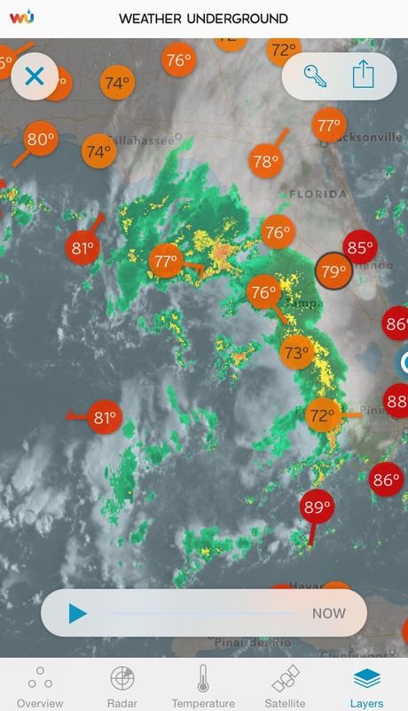
Broad closed surface low very noticeable this morning from visible satellite loop and surface reports but it has that subtropical look because of all the shear.
0 likes
-
northjaxpro

- S2K Supporter

- Posts: 8900
- Joined: Mon Sep 27, 2010 11:21 am
- Location: Jacksonville, FL
NHC had the Low estimated at 27N 87W earlier at 12Z this morning. It is at 1013 mb currently. This would have been a decently developed system were it not for the shear.Also NDG, the influence of the upper trough does lead into this Low having an hybrid/subtropcal look to it right now.
0 likes
NEVER, EVER SAY NEVER in the tropics and weather in general, and most importantly, with life itself!!
________________________________________________________________________________________
Fay 2008 Beryl 2012 Debby 2012 Colin 2016 Hermine 2016 Julia 2016 Matthew 2016 Irma 2017 Dorian 2019
________________________________________________________________________________________
Fay 2008 Beryl 2012 Debby 2012 Colin 2016 Hermine 2016 Julia 2016 Matthew 2016 Irma 2017 Dorian 2019
-
TheStormExpert

- Category 5

- Posts: 8487
- Age: 30
- Joined: Wed Feb 16, 2011 5:38 pm
- Location: Palm Beach Gardens, FL
Mentioned in the 2pm TWO.
A broad area of low pressure over the eastern Gulf of Mexico is
producing disorganized showers and thunderstorms. Significant
development of this system is not expected while it moves generally
northward at 10 to 15 mph over the next day or so. However,
locally heavy rains are likely over portions of Florida through
Tuesday morning.
* Formation chance through 48 hours...low...10 percent
* Formation chance through 5 days...low...10 percent
0 likes
The following post is NOT an official forecast and should not be used as such. It is just the opinion of the poster and may or may not be backed by sound meteorological data. It is NOT endorsed by storm2k.org.
-
TheStormExpert
- Category 5
- Posts: 8487
- Age: 30
- Joined: Wed Feb 16, 2011 5:38 pm
- Location: Palm Beach Gardens, FL


-
northjaxpro
- S2K Supporter
- Posts: 8900
- Joined: Mon Sep 27, 2010 11:21 am
- Location: Jacksonville, FL
I was wondering when NHC would finally give this Low a mention in the TWO.
Heavy rain down in Southeast Florida currently and a shield of heavy rain moving into Apalachee Bay and up in the Big Bend region on the eastern and northeastern side of the broad Low.
Heavy rain down in Southeast Florida currently and a shield of heavy rain moving into Apalachee Bay and up in the Big Bend region on the eastern and northeastern side of the broad Low.
0 likes
NEVER, EVER SAY NEVER in the tropics and weather in general, and most importantly, with life itself!!
________________________________________________________________________________________
Fay 2008 Beryl 2012 Debby 2012 Colin 2016 Hermine 2016 Julia 2016 Matthew 2016 Irma 2017 Dorian 2019
________________________________________________________________________________________
Fay 2008 Beryl 2012 Debby 2012 Colin 2016 Hermine 2016 Julia 2016 Matthew 2016 Irma 2017 Dorian 2019
Re: GOM looks messy
Got rain from it early this morning. Thundering now.
Sheared and running out of room. NE GOM is teasing us this year.
Sheared and running out of room. NE GOM is teasing us this year.
0 likes
-
Dean4Storms
- S2K Supporter
- Posts: 6355
- Age: 61
- Joined: Sun Aug 31, 2003 1:01 pm
- Location: Miramar Bch. FL

Any chance this could spin up into something before moving ashore?
0 likes
The above post is not official and should not be used as such. It is the opinion of the poster and may or may not be backed by sound meteorological data. It is not endorsed by any professional institution or storm2k.org. For official information, please refer to the NHC and NWS products.

Re: GOM looks messy
The tail of the trough looks like it may extend SW to near 25n 90w where the radar echos are showing thunderstorms. Maybe something could work its way to the surface there? The original vortex we spoted last night is getting sheared. Radar echoes are moving north, not sure if there is much left of the LLC.
0 likes

Re: GOM looks messy
OSM on Houston channel says models are predicting a low to form and possibly become tropical in NW GOM around a week from today. I believe it was NBC Ch2 in Houston
0 likes
TW in Texas Hill Country 
-
Houstonia

- S2K Supporter
- Posts: 829
- Age: 58
- Joined: Fri Oct 11, 2002 9:45 am
- Location: Sharpstown, Houston, Harris County, Southeast Texas.
Re: GOM looks messy
bohaiboy wrote:OSM on Houston channel says models are predicting a low to form and possibly become tropical in NW GOM around a week from today. I believe it was NBC Ch2 in Houston
David Paul at KHOU said the same thing.
0 likes
-
Extratropical94

- Professional-Met

- Posts: 3535
- Age: 29
- Joined: Wed Oct 20, 2010 6:36 am
- Location: Hamburg, Germany
- Contact:
A weak area of low pressure located over the northeastern Gulf of
Mexico about 90 miles west-southwest of Cedar Key, Florida, is
producing disorganized showers and a few thunderstorms.
Environmental conditions are unfavorable due to strong upper-level
winds and dry mid-level air, and significant development of this
system is not expected before it moves over the Florida Panhandle
later today. However, this system could produce locally heavy
rainfall over portions of northern Florida and southeastern Georgia
during the next day or so.
* Formation chance through 48 hours...low...near 10 percent
* Formation chance through 5 days...low...near 10 percent
0 likes
54° 11' 59'' N, 9° 9' 20'' E
Boomer Sooner!
Go Broncos! Go Cards! Go Niners!
- Daniel
Boomer Sooner!
Go Broncos! Go Cards! Go Niners!
- Daniel

Re: GOM looks messy
Northeast GOM or Fla. Big Bend is this years "almost hot spot".
http://www.ssd.noaa.gov/goes/east/gmex/flash-ir2.html
http://www.ssd.noaa.gov/goes/east/gmex/flash-ir2.html
0 likes
The following post is NOT an official forecast and should not be used as such. It is just the opinion of the poster and may or may not be backed by sound meteorological data. It is NOT endorsed by any professional institution including storm2k.org For Official Information please refer to the NHC and NWS products.

Re: GOM looks messy
There is a very obvious swirl that'll be moving inland near Tallahassee in the next few hours.
0 likes
-
TheStormExpert
- Category 5
- Posts: 8487
- Age: 30
- Joined: Wed Feb 16, 2011 5:38 pm
- Location: Palm Beach Gardens, FL
8am TWO. Down to 0/0 again.
A weak area of low pressure over the northeastern Gulf of Mexico
just to the east of Apalachicola, Florida, is producing disorganized
showers and a few thunderstorms. This system will move inland over
the Florida Panhandle later this morning, and development is not
likely. Locally heavy rainfall should affect portions of northern
Florida and southeastern Georgia during the next day or so.
* Formation chance through 48 hours...low...near 0 percent
* Formation chance through 5 days...low...near 0 percent
0 likes
The following post is NOT an official forecast and should not be used as such. It is just the opinion of the poster and may or may not be backed by sound meteorological data. It is NOT endorsed by storm2k.org.
-
BigB0882
- S2K Supporter
- Posts: 2219
- Joined: Thu Jul 03, 2003 12:08 am
- Location: Baton Rouge, LA
- Contact:
There is also something to watch out for in the next 7-10 days. I know that is a ways off but the Euro has been consistent with forming something in the far southwest Gulf and moving it NE while strengthening. The sheer in the Gulf better back off it that is to happen but either way it could be hinting at a very wet pattern for some of us along the Gulf in a week and a half or so.
0 likes
Who is online
Users browsing this forum: Christiana, Google [Bot], wwizard and 211 guests