GOM looks messy (Is Invest 94L)
Moderator: S2k Moderators
Forum rules

The posts in this forum are NOT official forecasts and should not be used as such. They are just the opinion of the poster and may or may not be backed by sound meteorological data. They are NOT endorsed by any professional institution or STORM2K. For official information, please refer to products from the National Hurricane Center and National Weather Service.
-
MGC

- S2K Supporter

- Posts: 5792
- Joined: Sun Mar 23, 2003 9:05 pm
- Location: Pass Christian MS, or what is left.
Re: GOM looks messy
Good to see this feature move ashore this morning. Looked like it was starting to get going....MGC
0 likes
-
lrak

- S2K Supporter
- Posts: 1770
- Age: 57
- Joined: Thu Jun 21, 2007 2:48 pm
- Location: Corpus Christi, TX
Re: GOM looks messy
Issued by NWS Corpus Christi, TX Sept 8th.
http://forecast.weather.gov/product.php ... glossary=1
LONG TERM (THURSDAY THROUGH TUESDAY)...STILL SOME RELATIVELY
GOOD CONSISTENCY IN THE EARLY PART OF THE LONG TERM THROUGH
SUNDAY...THEN SOME DIVERGENCE IN THE FORECAST WITH MUCH
UNCERTAINTY ESPECIALLY TUESDAY. IN THE SHORTER TERM (THURSDAY
THROUGH SUNDAY)...LOOKS LIKE THE BEST CHANCES FOR SHOWERS/STORMS
APPEAR THURSDAY AND FRIDAY. MOISTURE POOLS OVER SOUTH CENTRAL
TEXAS ON THURSDAY AND SLOWLY SEEPS DOWN THROUGH FRIDAY...WITH SOME
UPPER SUPPORT VIA DIFFLUENT FLOW ESPECIALLY THURSDAY NIGHT AND
FRIDAY (UPPER LOW OVER NORTHERN GULF STATES...BEST SEEN AT 250
MB...WILL APPROACH AREA BUT STAY EAST AS MID LATITUDE TROUGH
IMPACTS AREA). AS UPPER TROUGH MOVES EAST ON FRIDAY...FRONTAL
BOUNDARY WILL SWOOP INTO AREA AND BRING SOME COOLER AND DRIER AIR.
BOTH ECMWF...GFS AND CANADIAN AGREE THAT MOISTURE WILL BE MUCH
MORE LIMITED BY SUNDAY. AM HESITANT TO TOTALLY REMOVE POPS ON
SUNDAY...BUT WILL CONTINUE WITH THE TREND OF LOWERING POPS
SATURDAY AND SUNDAY (MONDAY TOO)...KEEPING THE CHANCE POPS
OFFSHORE. THEN THE UNCERTAINTY BEGINS. BOTH THE GFS AND ECMWF ARE
DEVELOPING A CLOSED CIRCULATION IN THE WESTERN GULF OF MEXICO ON
TUESDAY. GFS PUSHES IT INLAND TUESDAY NIGHT BETWEEN BROWNSVILLE
AND CORPUS CHRISTI AS A 1008MB LOW...WHILE THE ECMWF IS SLOWER AND
EVENTUALLY PUSHES A STRONGER SYSTEM NORTHEAST TOWARD THE NORTHERN
GULF OF MEXICO. BEST TO WAIT AND SEE WHAT HAPPENS...AS THERE HAS
BEEN A LOT OF SHEAR IN THE GULF (ALTHOUGH WHERE SYSTEM DEVELOPS
SHEAR IS WEAK FOR A TIME). AS A RESULT...WILL WAIT AND SEE AGAIN
WHAT HAPPENS AS GFS SOLUTION WOULD BE WET AND COOL ON TUESDAY
WHILE ECMWF MAY BE A BIT DRIER...AS ESPECIALLY DRIER LATER IN THE
WEEK IF IT MOVES THAT FAR EAST. WAY...WAY TOO EARLY TO START
GETTING EXCITED OVER SOMETHING THAT HAS NOT EVEN DEVELOPED
YET...SO LET US WAIT AND SEE. FOR TEMPERATURES...IN SHORT
GENERALLY WENT WITH A BLEND OF MOS AND SUPERBLEND...GOING A BIT
WARMER FOR THE DAYS WHERE POPS ARE LOWER THAN PREVIOUS RUN BUT
COOLER ON THURSDAY AND FRIDAY WHERE MORE RAIN IS POSSIBLE. NOT TOO
MUCH CHANGE FROM SUPERBLEND FOR LOW TEMPERATURES...ALTHOUGH DID
NOT GO AS COLD TO THE NORTH (AND NEAR THE COAST) AFTER FRIDAY.
Need some Storm2kers to break it down to surfer dude language.
I have not seen any model support for this to occur any help with models this far out would be great. Need some surf to let loose!
Thanks in advance
0 likes
AKA karl
Also
Personal Forecast Disclaimer:
My posts on this forum are NOT official forecast and should not be used as such. My posts are my basic observations and are definitely not backed by any "well some" meteorological knowledge. For official information, please refer to the NHC and NWS products.
Also
Personal Forecast Disclaimer:
My posts on this forum are NOT official forecast and should not be used as such. My posts are my basic observations and are definitely not backed by any "well some" meteorological knowledge. For official information, please refer to the NHC and NWS products.

Tweet from early this pm but Joe B is referencing 2002 both for pattern and winter. https://mobile.twitter.com/BigJoeBastar ... gr%5Etweet
0 likes

Re: GOM looks messy
Low center passed directly over top of me this morning near Winder, we got about 0.87" of rain from intermittent storms.

0 likes
The above post is not official and should not be used as such. It is the opinion of the poster and may or may not be backed by sound meteorological data. It is not endorsed by any professional institution or storm2k.org. For official information, please refer to the NHC and NWS products.
Re: GOM looks messy
The Gulf looks unseasonably shear-blasted on satellite. Not a good year for hurricane watching.
0 likes

Re:
Steve wrote:Tweet from early this pm but Joe B is referencing 2002 both for pattern and winter. https://mobile.twitter.com/BigJoeBastar ... gr%5Etweet
JB will keep loosing credibility if he keeps being biased with the Euro for tropical activity the rest of this hurricane season, time for him to let that model go when looking at its long range forecast.
BTW, current conditions in the GOM and Caribbean are nothing close to 2002, I keep sounding like a burnt record, lol.
0 likes
-
WPBWeather

- S2K Supporter
- Posts: 535
- Age: 65
- Joined: Thu Jul 18, 2013 12:33 pm
Re: Re:
NDG wrote:Steve wrote:Tweet from early this pm but Joe B is referencing 2002 both for pattern and winter. https://mobile.twitter.com/BigJoeBastar ... gr%5Etweet
JB will keep loosing credibility if he keeps being biased with the Euro for tropical activity the rest of this hurricane season, time for him to let that model go when looking at its long range forecast.
BTW, current conditions in the GOM and Caribbean are nothing close to 2002, I keep sounding like a burnt record, lol.
Come on. There are Pro Mets on this blog who are as absolute in their opinions as JB is in his. Only time will prove who was closest to being correct.
0 likes
Re: Re:
WPBWeather wrote:NDG wrote:Steve wrote:Tweet from early this pm but Joe B is referencing 2002 both for pattern and winter. https://mobile.twitter.com/BigJoeBastar ... gr%5Etweet
JB will keep loosing credibility if he keeps being biased with the Euro for tropical activity the rest of this hurricane season, time for him to let that model go when looking at its long range forecast.
BTW, current conditions in the GOM and Caribbean are nothing close to 2002, I keep sounding like a burnt record, lol.
Come on. There are Pro Mets on this blog who are as absolute in their opinions as JB is in his. Only time will prove who was closest to being correct.
How much time do you guys need to prove that conditions are nothing close to 2002 and will not change, if anything conditions will continue to go downhill, at least in our side of the Atlantic Basin.
0 likes
NDG,
Don't shoot the messenger. I made the same argument and felt like there were appreciable differences, but a professional met I trust told me it was a reasonable analog. I look at that as a "some similar characteristics, so average it in." I realize that it isn't 2002 and that water temperature profiles, pdo, the mjo, shear profiles, random other atmospheric conditions etc aren't the same. But it's september. And "if, then "should be considered from a watch and see standpoint. Hell, I think I got rain from 7 different systems that year and had some minor issues with both Isidore and Lili. 9/02 had like 8 named storms. This year it's 2 or 3 minor ones with 20 days to go. That year ended early-mid October, which outside of a stray late season storm, seems to happen sometimes in stronger el ninos. So it's watch and see for me in regard to whether the next 3 weeks end up throwing any 2002 curveballs at the north gulf. Initially, it looks like a super strong, early front will get down through here this weekend. I think as that trough lifts out, we get one of the strongest bounce-back ridges we've seen in a while. What I'm looking at is how long that holds and does the pattern repeat. Both of those are key to whether we are headed for a wrap or if there is still more season to go. Jmo. Btw, I think Bastardi has fallen more in love with Jamstech (sp) for his medium-long range stuff.
Don't shoot the messenger. I made the same argument and felt like there were appreciable differences, but a professional met I trust told me it was a reasonable analog. I look at that as a "some similar characteristics, so average it in." I realize that it isn't 2002 and that water temperature profiles, pdo, the mjo, shear profiles, random other atmospheric conditions etc aren't the same. But it's september. And "if, then "should be considered from a watch and see standpoint. Hell, I think I got rain from 7 different systems that year and had some minor issues with both Isidore and Lili. 9/02 had like 8 named storms. This year it's 2 or 3 minor ones with 20 days to go. That year ended early-mid October, which outside of a stray late season storm, seems to happen sometimes in stronger el ninos. So it's watch and see for me in regard to whether the next 3 weeks end up throwing any 2002 curveballs at the north gulf. Initially, it looks like a super strong, early front will get down through here this weekend. I think as that trough lifts out, we get one of the strongest bounce-back ridges we've seen in a while. What I'm looking at is how long that holds and does the pattern repeat. Both of those are key to whether we are headed for a wrap or if there is still more season to go. Jmo. Btw, I think Bastardi has fallen more in love with Jamstech (sp) for his medium-long range stuff.
0 likes
Re: GOM looks messy
Funny, as bad as it is it has the feel down here right now. Latent humidity.
0 likes
-
tropicwatch

- Category 5

- Posts: 3205
- Age: 60
- Joined: Sat Jun 02, 2007 10:01 am
- Location: Panama City Florida
- Contact:
Boy nw gulf has really blown up with convection today.
http://wwwghcc.msfc.nasa.gov/cgi-bin/get-goes?satellite=GOES-E%20CONUS&lat=27&lon=-94&info=vis&zoom=1&width=1000&height=800&quality=95&type=Animation&palette=ir2.pal&info=ir&numframes=20
http://wwwghcc.msfc.nasa.gov/cgi-bin/get-goes?satellite=GOES-E%20CONUS&lat=27&lon=-94&info=vis&zoom=1&width=1000&height=800&quality=95&type=Animation&palette=ir2.pal&info=ir&numframes=20
0 likes
Tropicwatch
Agnes 72', Eloise 75, Elena 85', Kate 85', Charley 86', Florence 88', Beryl 94', Dean 95', Erin 95', Opal 95', Earl 98', Georges 98', Ivan 2004', Arlene 2005', Dennis 2005', Ida 2009' Debby 2012' Irma 2017' Michael 2018'
Agnes 72', Eloise 75, Elena 85', Kate 85', Charley 86', Florence 88', Beryl 94', Dean 95', Erin 95', Opal 95', Earl 98', Georges 98', Ivan 2004', Arlene 2005', Dennis 2005', Ida 2009' Debby 2012' Irma 2017' Michael 2018'


Re: GOM looks messy
The tail of that front looks like it is dropping way down into the Bay of Campeche.
There was some model support for western gulf development last week.
Wxman57 will be on it if there is any chance.
There was some model support for western gulf development last week.
Wxman57 will be on it if there is any chance.
0 likes
-
tropicwatch
- Category 5
- Posts: 3205
- Age: 60
- Joined: Sat Jun 02, 2007 10:01 am
- Location: Panama City Florida
- Contact:
0 likes
Tropicwatch
Agnes 72', Eloise 75, Elena 85', Kate 85', Charley 86', Florence 88', Beryl 94', Dean 95', Erin 95', Opal 95', Earl 98', Georges 98', Ivan 2004', Arlene 2005', Dennis 2005', Ida 2009' Debby 2012' Irma 2017' Michael 2018'
Agnes 72', Eloise 75, Elena 85', Kate 85', Charley 86', Florence 88', Beryl 94', Dean 95', Erin 95', Opal 95', Earl 98', Georges 98', Ivan 2004', Arlene 2005', Dennis 2005', Ida 2009' Debby 2012' Irma 2017' Michael 2018'
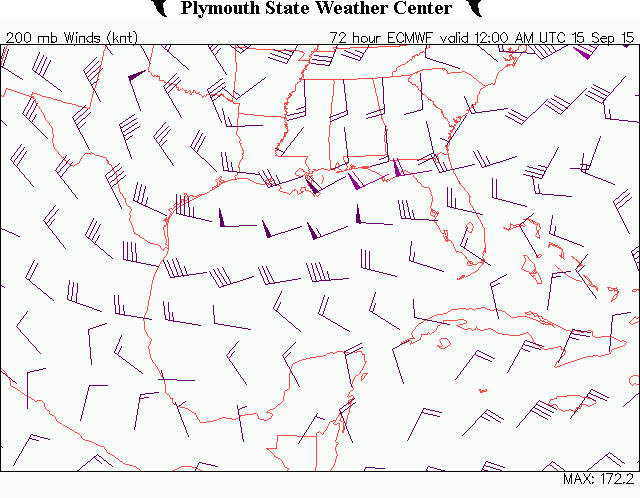
The same Euro model that was forecasting great UL conditions in the GOM for early next week is now forecasting 30-60 knot westerly UL winds across most of the GOM, maybe a 1% of development for the tail end of the cold front with those kind of conditions, and that's pretty generous out of my part 
But both the GFS and Euro show the remnants of Grace to track into the eastern GOM and interact with the UL trough that will be setting up across the north central GOM by the middle to late next week which will mean nothing but a rainy period for FL coming again for FL. I would not be surprised if the left over vorticity from Grace will become more detailed again but windshear will keep it in checked.
But both the GFS and Euro show the remnants of Grace to track into the eastern GOM and interact with the UL trough that will be setting up across the north central GOM by the middle to late next week which will mean nothing but a rainy period for FL coming again for FL. I would not be surprised if the left over vorticity from Grace will become more detailed again but windshear will keep it in checked.
0 likes
-
tropicwatch
- Category 5
- Posts: 3205
- Age: 60
- Joined: Sat Jun 02, 2007 10:01 am
- Location: Panama City Florida
- Contact:
Flights going from west to east over the gulf should pick up some time. 
0 likes
Tropicwatch
Agnes 72', Eloise 75, Elena 85', Kate 85', Charley 86', Florence 88', Beryl 94', Dean 95', Erin 95', Opal 95', Earl 98', Georges 98', Ivan 2004', Arlene 2005', Dennis 2005', Ida 2009' Debby 2012' Irma 2017' Michael 2018'
Agnes 72', Eloise 75, Elena 85', Kate 85', Charley 86', Florence 88', Beryl 94', Dean 95', Erin 95', Opal 95', Earl 98', Georges 98', Ivan 2004', Arlene 2005', Dennis 2005', Ida 2009' Debby 2012' Irma 2017' Michael 2018'

Re: GOM looks messy
0 likes
The following post is NOT an official forecast and should not be used as such. It is just the opinion of the poster and may or may not be backed by sound meteorological data. It is NOT endorsed by any professional institution including storm2k.org For Official Information please refer to the NHC and NWS products.
Those winds aloft will be strong, but that was a 72 hour run. There was always supposed to be a brisk upper flow for a few days, then that trough lifts out. Pretty much guaranteed the flag symbol level winds (60 or 70?) will lift out Tuesday or Wednesay. That was going to happen anyway whether a system developed underneath or not. Because it's a rare early September front (supposed to be 80 and sunny here tomorrow), it's not going to be reinforced or lead to a pattern where the westerly flow in the Southeast sets up for the late fall and winter. We will have to just watch things, though admittedly the ECMWF isn't as reliable in 2015 as some people think or as reliable as it has been in other years with different conditions.
0 likes
Who is online
Users browsing this forum: Google Adsense [Bot], KirbyDude25, Lizzytiz1, StPeteMike, wxman57 and 199 guests