Discussion of Intense Tropical Cyclones

This is the general tropical discussion area. Anyone can take their shot at predicting a storms path.

Moderator: S2k Moderators

Forum rules

The posts in this forum are NOT official forecasts and should not be used as such. They are just the opinion of the poster and may or may not be backed by sound meteorological data. They are NOT endorsed by any professional institution or STORM2K. For official information, please refer to products from the National Hurricane Center and National Weather Service.

Help Support Storm2K
Message
Author
User avatar
1900hurricane
Category 5
Category 5
Posts: 6044
Age: 32
Joined: Fri Feb 06, 2015 12:04 pm
Location: Houston, TX
Contact:

Re: Intense Tropical Cyclone Discussion

#341 Postby 1900hurricane » Sat Jan 26, 2019 3:36 pm

supercane4867 wrote:The problem with Muifa is that it started to weaken just after rapidly intensified, which did not sustain the impressive satellite presentation long enough as typical 150kt+ storms do.
It's clearly at least a low end Cat.5, but I won't go too far beyond that.

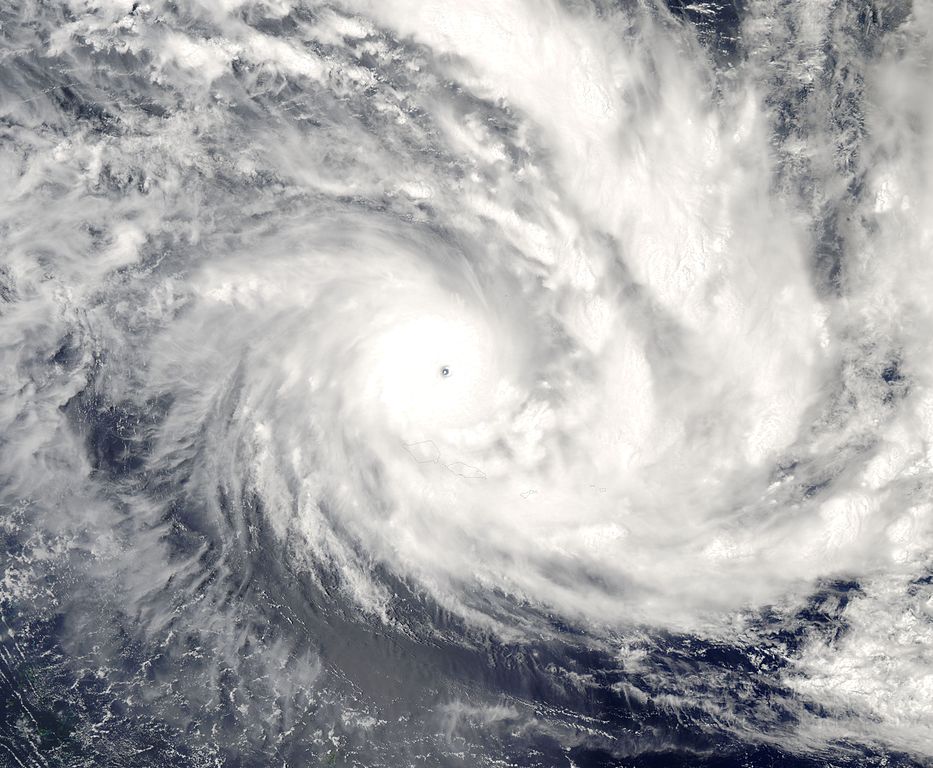
I'd also like to present Cyclone Olaf of 2005. It's basically a SPAC version of Dianmu with the most perfect structure ever observed in southern hemisphere besides Monica. The cyclone undergone a phase of rapid intensification under extreme favorable conditions consisting of 31°C SSTs with low shear and strong diffluence aloft. MODIS imagery indicate the eye is well over 20°C and is surrounded by insanely cold CDO. A barometric pressure of 931mb was recorded on an island of American Samoa when Olaf passed more than 25km to its east after significantly weakened. It's possible the central pressure went as low as 900mb at the time and we can only imagine how low it could have been near peak intensity.

http://i.imgur.com/zyQ7Wuq.jpg

http://upload.wikimedia.org/wikipedia/commons/thumb/2/21/Cyclone_Olaf_16_feb_2005_0110Z.jpg/933px-Cyclone_Olaf_16_feb_2005_0110Z.jpg

Since I can quickly implement the Schloemer Equation via Python, I used it with Olaf '05, and the results are pretty eye opening. Using a 18.52 km (10 nm) RMW that I've estimated using microwave imagery (below) and spitballing a very low 1000 mb outermost closed isobar (just an educated guess since I don't have access to reanalysis data with the government shutdown) along with the measured 931 mb pressure estimated at 25 km from the center of Olaf, I end up getting Tip type pressure estimates. Even if Olaf passed a little closer and the RMW just touched the observation side, that's still good for an 890 mb pressure estimate. A developing outer eyewall may have affected the pressure gradient a little, but I don't think that would have resulted in a pressure above 900 mb.

Image

Image

 https://twitter.com/1900hurricane/status/1089391885225996288


6 likes   
Contract Meteorologist. TAMU & MSST. Fiercely authentic, one of a kind. We are all given free will, so choose a life meant to be lived. We are the Masters of our own Stories.
Opinions expressed are mine alone.

Follow me on Twitter at @1900hurricane : Read blogs at https://1900hurricane.wordpress.com/

User avatar
Ptarmigan
Category 5
Category 5
Posts: 5272
Joined: Wed Aug 16, 2006 9:06 pm

Re: Discussion of Intense Tropical Cyclones

#342 Postby Ptarmigan » Sun Feb 10, 2019 3:52 pm

Some of these South Pacific tropical cyclones are very intense and on par with West Pacific.

The South Pacific often gets overlooked.
0 likes   

NotoSans
Category 5
Category 5
Posts: 1366
Age: 24
Joined: Sun Sep 27, 2015 1:15 am
Location: Hong Kong
Contact:

Re: Discussion of Intense Tropical Cyclones

#343 Postby NotoSans » Fri Apr 19, 2019 11:31 pm

It is worth noting that in Michael's report, NHC utilised the GBVTD technique to compute actual wind velocities from radar data (see last para in p 4 of the TCR). The same technique had been used by JMA to conduct a re-analysis of Haiyan's intensity: https://journals.ametsoc.org/doi/pdf/10 ... -17-0120.1
1 likes   
Personal Forecast Disclaimer:
The posts in this forum are NOT official forecast and should not be used as such. They are just the opinion of the poster and may or may not be backed by sound meteorological data. They are NOT endorsed by any professional institution or storm2k.org. For official information, please refer to RSMC and NWS products.

CrazyC83
Professional-Met
Professional-Met
Posts: 33393
Joined: Tue Mar 07, 2006 11:57 pm
Location: Deep South, for the first time!

Re: Discussion of Intense Tropical Cyclones

#344 Postby CrazyC83 » Sat Apr 20, 2019 1:38 am

NotoSans wrote:It is worth noting that in Michael's report, NHC utilised the GBVTD technique to compute actual wind velocities from radar data (see last para in p 4 of the TCR). The same technique had been used by JMA to conduct a re-analysis of Haiyan's intensity: https://journals.ametsoc.org/doi/pdf/10 ... -17-0120.1


Interesting they also estimate the pressure at 906 mb, which would be incredibly high for an intensity in the 175-190 kt range, and would be even higher than the Schloemer equation estimate of the pressure at landfall on Leyte, which is around 895-900 mb (which was likely after some weakening).
0 likes   

User avatar
Ptarmigan
Category 5
Category 5
Posts: 5272
Joined: Wed Aug 16, 2006 9:06 pm

Re: Discussion of Intense Tropical Cyclones

#345 Postby Ptarmigan » Mon May 06, 2019 9:47 pm

CrazyC83 wrote:
NotoSans wrote:It is worth noting that in Michael's report, NHC utilised the GBVTD technique to compute actual wind velocities from radar data (see last para in p 4 of the TCR). The same technique had been used by JMA to conduct a re-analysis of Haiyan's intensity: https://journals.ametsoc.org/doi/pdf/10 ... -17-0120.1


Interesting they also estimate the pressure at 906 mb, which would be incredibly high for an intensity in the 175-190 kt range, and would be even higher than the Schloemer equation estimate of the pressure at landfall on Leyte, which is around 895-900 mb (which was likely after some weakening).


I would be curious about the ambient pressure Haiyan was in at the time.
0 likes   

User avatar
BYG Jacob
Category 3
Category 3
Posts: 893
Age: 26
Joined: Wed Aug 23, 2017 3:46 pm
Location: Tucson, Arizona

Re: Discussion of Intense Tropical Cyclones

#346 Postby BYG Jacob » Tue May 07, 2019 5:24 am

Ptarmigan wrote:
CrazyC83 wrote:
NotoSans wrote:It is worth noting that in Michael's report, NHC utilised the GBVTD technique to compute actual wind velocities from radar data (see last para in p 4 of the TCR). The same technique had been used by JMA to conduct a re-analysis of Haiyan's intensity: https://journals.ametsoc.org/doi/pdf/10 ... -17-0120.1


Interesting they also estimate the pressure at 906 mb, which would be incredibly high for an intensity in the 175-190 kt range, and would be even higher than the Schloemer equation estimate of the pressure at landfall on Leyte, which is around 895-900 mb (which was likely after some weakening).


I would be curious about the ambient pressure Haiyan was in at the time.

1012 or so iirc. Haiyian was getting shoved due west basically the whole time.
0 likes   

User avatar
1900hurricane
Category 5
Category 5
Posts: 6044
Age: 32
Joined: Fri Feb 06, 2015 12:04 pm
Location: Houston, TX
Contact:

Re: Discussion of Intense Tropical Cyclones

#347 Postby 1900hurricane » Tue May 07, 2019 3:30 pm

BYG Jacob wrote:
Ptarmigan wrote:
CrazyC83 wrote:
Interesting they also estimate the pressure at 906 mb, which would be incredibly high for an intensity in the 175-190 kt range, and would be even higher than the Schloemer equation estimate of the pressure at landfall on Leyte, which is around 895-900 mb (which was likely after some weakening).


I would be curious about the ambient pressure Haiyan was in at the time.

1012 or so iirc. Haiyian was getting shoved due west basically the whole time.

The outermost closed isobar (OCI) for Haiyan was actually somewhere between 1000-1008 mb. Low surface pressures and heights aloft due to some combination of MJO/Kelvin/Equatorial Rossby is just as responsible for Haiyan's brisk motion as subtropical ridging to its north. It was this gradient region between the two that Haiyan traversed.
1 likes   
Contract Meteorologist. TAMU & MSST. Fiercely authentic, one of a kind. We are all given free will, so choose a life meant to be lived. We are the Masters of our own Stories.
Opinions expressed are mine alone.

Follow me on Twitter at @1900hurricane : Read blogs at https://1900hurricane.wordpress.com/

User avatar
1900hurricane
Category 5
Category 5
Posts: 6044
Age: 32
Joined: Fri Feb 06, 2015 12:04 pm
Location: Houston, TX
Contact:

Re: Discussion of Intense Tropical Cyclones

#348 Postby 1900hurricane » Mon Jun 10, 2019 1:55 pm

Just wanted to take a moment to post about the updated IBTrACS page hosted by UNC Asheville. The dataset is constantly updated with finalized tropical cyclone information from all major agencies and some other older datasets dating back as early as 1842!. For systems with geostationary imagery available, 3 hr IR imagery is also provided by HURSAT in a modified color Dvorak scale, which makes one to one comparisons of tropical cyclones about as close as it gets! Just as an example, here's the Patricia '15/Nuri '14 comparison I had on the first page. When available, data includes Vmax, Pmin, wind radii, ROCI, and more!

ImageImage

Image
7 likes   
Contract Meteorologist. TAMU & MSST. Fiercely authentic, one of a kind. We are all given free will, so choose a life meant to be lived. We are the Masters of our own Stories.
Opinions expressed are mine alone.

Follow me on Twitter at @1900hurricane : Read blogs at https://1900hurricane.wordpress.com/

User avatar
1900hurricane
Category 5
Category 5
Posts: 6044
Age: 32
Joined: Fri Feb 06, 2015 12:04 pm
Location: Houston, TX
Contact:

Re: Discussion of Intense Tropical Cyclones

#349 Postby 1900hurricane » Mon Jun 24, 2019 10:32 pm

While we wait for tropical cyclone activity to pick up this season, who wants to play a little game?

 https://twitter.com/1900hurricane/status/1143359097808531456


 https://twitter.com/1900hurricane/status/1143360340857634816


4 likes   
Contract Meteorologist. TAMU & MSST. Fiercely authentic, one of a kind. We are all given free will, so choose a life meant to be lived. We are the Masters of our own Stories.
Opinions expressed are mine alone.

Follow me on Twitter at @1900hurricane : Read blogs at https://1900hurricane.wordpress.com/

Chris90
Category 2
Category 2
Posts: 637
Age: 34
Joined: Thu Jun 01, 2017 9:36 pm

Re: Discussion of Intense Tropical Cyclones

#350 Postby Chris90 » Mon Jun 24, 2019 10:53 pm

I don't have a twitter account, but I read the twitter thread, can I just play the game here?
I'm aware which one of those is Irma and I have a decent memory of the recon data that was closest to the time of that image, but I think my guess is going to go to the storm on the left. Impressive cloud tops and a bit more symmetrical than the storm on the top right (I'm unsure of what storms the other two are, I only recognize Irma. I'm guessing either one or both are WPAC storms due to how cold the cloud tops are and presentation, also I know you have an affinity for that basin from reading this board long enough. :D)
The storm on the top right has an impressive eye and cold clouds tops, but it's a bit elongated in appearance, which is why I'm leaning towards storm on the left.
1 likes   
Solar Aquarian
Lunar Cancerian
:uarrow: Sagittarian

User avatar
euro6208
Category 5
Category 5
Posts: 18547
Joined: Mon Mar 08, 2004 7:50 pm
Location: Guam

Re: Discussion of Intense Tropical Cyclones

#351 Postby euro6208 » Tue Jun 25, 2019 6:36 am

It's amazing what recon can find vs what dvorak says.
0 likes   
Remember, all of my post aren't official. For official warnings and discussions, Please refer to your local NWS products...

NWS for the Western Pacific

https://www.weather.gov/gum/

styzeb
Tropical Low
Tropical Low
Posts: 14
Joined: Mon Oct 03, 2016 2:47 am

Re: Discussion of Intense Tropical Cyclones

#352 Postby styzeb » Tue Jun 25, 2019 10:09 am

1900hurricane wrote:While we wait for tropical cyclone activity to pick up this season, who wants to play a little game?

https://twitter.com/1900hurricane/status/1143359097808531456
https://twitter.com/1900hurricane/status/1143360340857634816


Left: Irma 1981 (135 kt typhoon, JTWC), top right: Irma 1989 (140 kt typhoon, JTWC), bottom right: Irma 2017 (155 kt hurricane, NHC).
4 likes   

User avatar
1900hurricane
Category 5
Category 5
Posts: 6044
Age: 32
Joined: Fri Feb 06, 2015 12:04 pm
Location: Houston, TX
Contact:

Re: Discussion of Intense Tropical Cyclones

#353 Postby 1900hurricane » Tue Jun 25, 2019 3:36 pm

styzeb wrote:
1900hurricane wrote:While we wait for tropical cyclone activity to pick up this season, who wants to play a little game?

https://twitter.com/1900hurricane/status/1143359097808531456
https://twitter.com/1900hurricane/status/1143360340857634816


Left: Irma 1981 (135 kt typhoon, JTWC), top right: Irma 1989 (140 kt typhoon, JTWC), bottom right: Irma 2017 (155 kt hurricane, NHC).

That is correct! NotoSans and mrbagyo also figured it out on Twitter. I revealed some more info on each of those storms in a new thread of Tweets, beginning with this one.

 https://twitter.com/1900hurricane/status/1143597235554439168


3 likes   
Contract Meteorologist. TAMU & MSST. Fiercely authentic, one of a kind. We are all given free will, so choose a life meant to be lived. We are the Masters of our own Stories.
Opinions expressed are mine alone.

Follow me on Twitter at @1900hurricane : Read blogs at https://1900hurricane.wordpress.com/

styzeb
Tropical Low
Tropical Low
Posts: 14
Joined: Mon Oct 03, 2016 2:47 am

Re: Discussion of Intense Tropical Cyclones

#354 Postby styzeb » Sun Jun 30, 2019 4:34 am

Image

Super Typhoon Yuri on Nov 26, 1991.
5 likes   

User avatar
Ptarmigan
Category 5
Category 5
Posts: 5272
Joined: Wed Aug 16, 2006 9:06 pm

Re: Discussion of Intense Tropical Cyclones

#355 Postby Ptarmigan » Sun Jul 07, 2019 1:28 pm

styzeb wrote:
1900hurricane wrote:While we wait for tropical cyclone activity to pick up this season, who wants to play a little game?

https://twitter.com/1900hurricane/status/1143359097808531456
https://twitter.com/1900hurricane/status/1143360340857634816


Left: Irma 1981 (135 kt typhoon, JTWC), top right: Irma 1989 (140 kt typhoon, JTWC), bottom right: Irma 2017 (155 kt hurricane, NHC).


I would of said Storm 2 is the most intense due to the cold cloud tops (Irma 1989).

Irma 2017 is the strongest in terms of wind.

That is one reason why I do not trust Dvorak technique much.
0 likes   

supercane4867
Category 5
Category 5
Posts: 4966
Joined: Wed Nov 14, 2012 10:43 am

Re: Discussion of Intense Tropical Cyclones

#356 Postby supercane4867 » Thu Jul 11, 2019 7:25 pm

Just found this video of Hurricane Michael landfalling in Mexico Beach with only 74K views. I believe this is the first ever footage of actual CAT5 conditions taken by camera. You can see the complete white out in eyewall along with catastrophic storm surge carrying debris...very astonishing

https://www.youtube.com/watch?v=wiL3QKraaTY


Link: https://youtu.be/wiL3QKraaTY
5 likes   

User avatar
1900hurricane
Category 5
Category 5
Posts: 6044
Age: 32
Joined: Fri Feb 06, 2015 12:04 pm
Location: Houston, TX
Contact:

Re: Discussion of Intense Tropical Cyclones

#357 Postby 1900hurricane » Sun Jul 14, 2019 10:41 am

Ptarmigan wrote:
styzeb wrote:
1900hurricane wrote:While we wait for tropical cyclone activity to pick up this season, who wants to play a little game?

https://twitter.com/1900hurricane/status/1143359097808531456
https://twitter.com/1900hurricane/status/1143360340857634816


Left: Irma 1981 (135 kt typhoon, JTWC), top right: Irma 1989 (140 kt typhoon, JTWC), bottom right: Irma 2017 (155 kt hurricane, NHC).


I would of said Storm 2 is the most intense due to the cold cloud tops (Irma 1989).

Irma 2017 is the strongest in terms of wind.

That is one reason why I do not trust Dvorak technique much.

JTWC of yesterday would actually agree with you regarding which of the systems is the strongest. The highest winds they gave Irma '89 was 140 kt, but in those days, that also meant they were analyzing an 898 mb typhoon (deeper than the other two) due to their reliance on the Atkinson & Holliday Wind/Pressure Relationship. JTWC loved that thing and rarely deviated from it with intense systems because accurate winds in the eyewall were so hard to come by with the technology at the time. Therefore, JTWC would take the measured pressure and hug the output from AH77. And why not, because "in contrast to previous maximum wind/minimum pressure relationships in the western North Pacific, [AH77] is the only one derived from sufficient ground truth." At least that's what the authors of the paper concluded. I used python to output the AH77 pressures at wind speeds from 25 kt to 185 kt below.

25 kt 1002 mb
30 kt 1000 mb
35 kt 997 mb
40 kt 994 mb
45 kt 991 mb
50 kt 987 mb
55 kt 984 mb
60 kt 980 mb
65 kt 976 mb
70 kt 972 mb
75 kt 967 mb
80 kt 963 mb
85 kt 958 mb
90 kt 953 mb
95 kt 948 mb
100 kt 943 mb
105 kt 938 mb
110 kt 933 mb
115 kt 927 mb
120 kt 922 mb
125 kt 916 mb
130 kt 910 mb
135 kt 904 mb
140 kt 898 mb
145 kt 891 mb
150 kt 885 mb
155 kt 879 mb
160 kt 872 mb
165 kt 865 mb
170 kt 858 mb
175 kt 851 mb
180 kt 844 mb
185 kt 837 mb

Irma '81's recorded pressure of 905 mb was assigned a 135 kt intensity. Had Irma '17 occurred in the WPac later recon era, its 915 mb pressure (since wind recording dropsondes weren't around yet) would only be assigned a 125 kt intensity. This staunch stance on the relationship between pressure and wind that JTWC had in place led to some very conservative takes on Dvorak intensities, which is all they had to lean on after recon ended mid-way through the 1987 season. JTWC remained exceptionally conservative until 1992 when they began using the T7.5 155 kt intensity for the first time since without aircraft data, but they still generally downplayed the top end storms all the way until Haiyan forced their hand in 2013.

Because of all this, comparing storms basin to basin or even in the same basin from different eras is particularly troublesome. A daunting amount of reanalysis work is needed to clean up JTWC's historical best track to make it of even acceptable quality in my opinion. I've actually started to kick the tires on that very thing myself, trying to do some mostly KZC-based reanalysis work in the WPac late recon era whenever I have a free moment. I've actually taken a look at Irma '81 as part of this project. My peak intensity estimate at the time of the 905 mb pressure is 160 kt, which I feel is much more representative of the T7.5+ satellite presentation, as well as overall.

 https://twitter.com/1900hurricane/status/1143608200127758347


6 likes   
Contract Meteorologist. TAMU & MSST. Fiercely authentic, one of a kind. We are all given free will, so choose a life meant to be lived. We are the Masters of our own Stories.
Opinions expressed are mine alone.

Follow me on Twitter at @1900hurricane : Read blogs at https://1900hurricane.wordpress.com/

User avatar
Ptarmigan
Category 5
Category 5
Posts: 5272
Joined: Wed Aug 16, 2006 9:06 pm

Re: Discussion of Intense Tropical Cyclones

#358 Postby Ptarmigan » Sun Jul 14, 2019 10:54 am

1900hurricane wrote:JTWC of yesterday would actually agree with you regarding which of the systems is the strongest. The highest winds they gave Irma '89 was 140 kt, but in those days, that also meant they were analyzing an 898 mb typhoon (deeper than the other two) due to their reliance on the Atkinson & Holliday Wind/Pressure Relationship. JTWC loved that thing and rarely deviated from it with intense systems because accurate winds in the eyewall were so hard to come by with the technology at the time. Therefore, JTWC would take the measured pressure and hug the output from AH77. And why not, because "in contrast to previous maximum wind/minimum pressure relationships in the western North Pacific, [AH77] is the only one derived from sufficient ground truth." At least that's what the authors of the paper concluded. I used python to output the AH77 pressures at wind speeds from 25 kt to 185 kt below.

25 kt 1002 mb
30 kt 1000 mb
35 kt 997 mb
40 kt 994 mb
45 kt 991 mb
50 kt 987 mb
55 kt 984 mb
60 kt 980 mb
65 kt 976 mb
70 kt 972 mb
75 kt 967 mb
80 kt 963 mb
85 kt 958 mb
90 kt 953 mb
95 kt 948 mb
100 kt 943 mb
105 kt 938 mb
110 kt 933 mb
115 kt 927 mb
120 kt 922 mb
125 kt 916 mb
130 kt 910 mb
135 kt 904 mb
140 kt 898 mb
145 kt 891 mb
150 kt 885 mb
155 kt 879 mb
160 kt 872 mb
165 kt 865 mb
170 kt 858 mb
175 kt 851 mb
180 kt 844 mb
185 kt 837 mb

Irma '81's recorded pressure of 905 mb was assigned a 135 kt intensity. Had Irma '17 occurred in the WPac later recon era, its 915 mb pressure (since wind recording dropsondes weren't around yet) would only be assigned a 125 kt intensity. This staunch stance on the relationship between pressure and wind that JTWC had in place led to some very conservative takes on Dvorak intensities, which is all they had to lean on after recon ended mid-way through the 1987 season. JTWC remained exceptionally conservative until 1992 when they began using the T7.5 155 kt intensity for the first time since without aircraft data, but they still generally downplayed the top end storms all the way until Haiyan forced their hand in 2013.

Because of all this, comparing storms basin to basin or even in the same basin from different eras is particularly troublesome. A daunting amount of reanalysis work is needed to clean up JTWC's historical best track to make it of even acceptable quality in my opinion. I've actually started to kick the tires on that very thing myself, trying to do some mostly KZC-based reanalysis work in the WPac late recon era whenever I have a free moment. I've actually taken a look at Irma '81 as part of this project. My peak intensity estimate at the time of the 905 mb pressure is 160 kt, which I feel is much more representative of the T7.5+ satellite presentation, as well as overall.

https://twitter.com/1900hurricane/status/1143608200127758347


West Pacific has lower ambient pressure than the Atlantic. Every basin is different.

The 185 knot tropical cyclone is Hurricane Patricia in the East Pacific, which had central pressure of 872 millibars. It was a smaller sized hurricane than typhoons of the West Pacific. Super Typhoon Tip had central pressure of 870 millibars and 165 knot winds. It was a much larger storm as it is the largest known tropical cyclone. The pressure gradient is much steeper in Patricia than in Tip.

Both occurred in October, in which ambient pressure would be higher than in the summer.
0 likes   

User avatar
1900hurricane
Category 5
Category 5
Posts: 6044
Age: 32
Joined: Fri Feb 06, 2015 12:04 pm
Location: Houston, TX
Contact:

Re: Discussion of Intense Tropical Cyclones

#359 Postby 1900hurricane » Sun Jul 14, 2019 12:29 pm

That's the great thing about the Knaff-Zehr-Courtney Wind/Pressure Relationship, it takes into account environmental background pressures (via the outermost closed isobar) and the size of the storm (via either the average radius of tropical storm force winds or the radius of the outermost closed isobar). It also takes into account a storm's latitude and forward speed. Both versions that use the tropical storm force wind radius and the radius of the outermost closed isobar compare very favorably against NHC's best track.

Image

Image
4 likes   
Contract Meteorologist. TAMU & MSST. Fiercely authentic, one of a kind. We are all given free will, so choose a life meant to be lived. We are the Masters of our own Stories.
Opinions expressed are mine alone.

Follow me on Twitter at @1900hurricane : Read blogs at https://1900hurricane.wordpress.com/

User avatar
euro6208
Category 5
Category 5
Posts: 18547
Joined: Mon Mar 08, 2004 7:50 pm
Location: Guam

Re: Discussion of Intense Tropical Cyclones

#360 Postby euro6208 » Sun Jul 21, 2019 5:36 am

What a year it is going to be. In October, it will be the 30th year anniversary of Obsolete Super Typhoon Tip which set the record for lowest pressure ever recorded in world history during the recon era in the WPAC. Of course, since recon stopped in 1987, about a dozen typhoons probrably were stronger pressure wise. Truly a loss in meteorology. (Wind wise?) :eek: WPAC records are outdated.

How many more typhoons would have peaked below -900?
0 likes   
Remember, all of my post aren't official. For official warnings and discussions, Please refer to your local NWS products...

NWS for the Western Pacific

https://www.weather.gov/gum/


Return to “Talkin' Tropics”

Who is online

Users browsing this forum: gta251990, Ian2401, LarryWx, zzzh and 68 guests