What's the Curse of The 'I' list ?
Isabelle 2003
Ivan 2004
Ike 2008
Igor 2010
Irma 2017
Who else?
Discussion of Intense Tropical Cyclones
Moderator: S2k Moderators
Forum rules

The posts in this forum are NOT official forecasts and should not be used as such. They are just the opinion of the poster and may or may not be backed by sound meteorological data. They are NOT endorsed by any professional institution or STORM2K. For official information, please refer to products from the National Hurricane Center and National Weather Service.
-
WeatherGuesser
- Category 5

- Posts: 2672
- Joined: Tue Jun 29, 2010 6:46 am

Re: Discussion of Intense Tropical Cyclones
WeatherGuesser wrote:What's the Curse of The 'I' list ?
Isabelle 2003
Ivan 2004
Ike 2008
Igor 2010
Irma 2017
Who else?
If we're going purely on intensity there's Isaac in 2000 and Iris in 2001 as well--both Cat 4.
0 likes
The above post is not official and should not be used as such. It is the opinion of the poster and may or may not be backed by sound meteorological data. It is not endorsed by any professional institution or storm2k.org. For official information, please refer to the NHC and NWS products.
-
NotoSans
- Category 5
- Posts: 1366
- Age: 24
- Joined: Sun Sep 27, 2015 1:15 am
- Location: Hong Kong
- Contact:
Re: Discussion of Intense Tropical Cyclones
I would say this is a major failure for the Dvorak technique but other techniques like AMSU actually accurately assess Irma's intensity.
AL, 11, 201709050658, 30, AMSU, IP, , 1658N, 5661W, , 2, 149, 1, 925, 1, MEAS, , , , , , , , , , , , 23, , L, CIMS, , , , , , , , 925, , NOAA19, , , , , , , , , , , , , , , , , , , ,
AL, 11, 201709052302, 30, AMSU, IP, , 1714N, 6019W, , 2, 156, 1, 910, 1, MEAS, , , , , , , , , , , , 18, , L, CIMS, , , , , , , , 910, , NOAA18, , , , , , , , , , , , , , , , , , , ,
1 likes
Personal Forecast Disclaimer:
The posts in this forum are NOT official forecast and should not be used as such. They are just the opinion of the poster and may or may not be backed by sound meteorological data. They are NOT endorsed by any professional institution or storm2k.org. For official information, please refer to RSMC and NWS products.
The posts in this forum are NOT official forecast and should not be used as such. They are just the opinion of the poster and may or may not be backed by sound meteorological data. They are NOT endorsed by any professional institution or storm2k.org. For official information, please refer to RSMC and NWS products.

Re: Discussion of Intense Tropical Cyclones
1900hurricane wrote:mrbagyo wrote:Was the 890 mb reading on STY Betty (August 1987 - recon farewell) just an estimate or recon data. Because if its recon, IMO, 140 knots is pretty low for such a compact tight storm. The reanalysis of Knaff would be pretty decent estimate(170+ knots peak).
Landfall intensity in best track is 135 I guess, that's just 5 knot reduction from peak. I think it's possible that Betty actually made landfall in N Samar as a Cat5 instead of "just" being a strong cat 4.
Betty doesnt possess the most impressive CDO but men, she is one tight system and there was also a strong ridging to its north that forced her to take a west track. Any thoughts?
The 1987 Joint Typhoon Warning Center Annual Tropical Cyclone Report doesn't explicitly mention that it was recon measured, but it can be inferred with reasonable confidence from the wording that it "had the lowest reported minimum sea-level pressure [of the year] (891 mb)." Unlike many of the other JTWC reports, the 1987 report doesn't list all the recon fixes for the year, but Nina was also estimated to have had a pressure of 891 mb (AH77 output for 145 kt), so that in itself is noteworthy enough to reasonably conclude that the 891 mb was a direct recon measurement.
It is also noteworthy that you brought up the appearance of Betty's CDO. It's not like it's horrible, but it wouldn't be something I would expect a pressure below 900 mb in on a glance. Flo '90 is another one of those storms, which had a recon measured 891 mb as well. Betty '87 and Flo '90 are pictured at peak intensity below, respectively. Storms like these are just a couple of examples that show how much more we still have to learn about tropical cyclones.
I guess we may need to rewrite the dvorak technique because it is useless. Dvorak and ADT still 6.5 (Alot better if it went up to 7.0 Cat 5 but no)and under 140 knots for Irma but we know how strong Irma was. Where is this talk of a CDG surrounding the eye or WMG eye embedded? Now it makes you wonder just how strong other TC's especially the typhoons were.
Last edited by euro6208 on Wed Sep 06, 2017 4:49 am, edited 2 times in total.
0 likes
Remember, all of my post aren't official. For official warnings and discussions, Please refer to your local NWS products...
NWS for the Western Pacific
https://www.weather.gov/gum/
NWS for the Western Pacific
https://www.weather.gov/gum/
Re: Discussion of Intense Tropical Cyclones
CrazyC83 wrote:1900hurricane wrote:CrazyC83 wrote:
Using Dvorak alone, 150 kt would have likely been the most reasonable intensity for Meranti. That was based on a mix of 7.0's and 7.5's and CMG mostly but not entirely wrapping around.
Given the range of data, I'd go a touch higher and say 155 kt for its real peak intensity.
The DT was absolutely a 7.5 for at least 12Z on September 13th. The >20*C eye was embedded in the cold medium grey to a full degree. Certainly there were times where it looked like JTWC was running a little hot on their satellite bulletins, but definitely not between 09Z and 12Z.
That is clearly T7.5 (I was too busy with school work to focus there for a bit), so maybe 160 kt is the best guess for peak intensity at that time.1900hurricane wrote:I actually have a number of thoughts I've recently developed that I'd like to express regarding the estimation of very intense tropical cyclones. Much of this has to do with JTWC's intensity estimates for Super Typhoon Meranti, but it also goes beyond that as well.
First off, I want to say that I appreciate JTWC trying to expand their suite of intensity analysis beyond the Dvorak Technique for the most intense storms. The Dvorak Technique is certainly has the most data and verification behind it, but as stated earlier in this thread, the intensities at the upper end of the scale are a little more uncertain, and is generally thought to underestimate the most intense storms to some degree. Data from storms like Rita '05, Megi '10, and Patricia '15 seem to support that. (Random note, Megi and Meranti actually had very similar CDOs near peak intensity). That's just the nature of the technique due to the limited number of cases available to Vernon Dvorak when he completed the framework of the technique. In Meranti's case, DTs of 7.5 would only yield an intensity estimate of 155 kt. However, between 06Z and 18Z on September 13th, all intensity estimates that were reliant on microwave data instead of IR (AMSU, ATMS, and SSMIS) ranged between 154 kt to 179 kt, generally higher than the DTs, and sometimes considerably. JTWC took note of this and factored it into their intensity estimates, which is fine with me.
Second, while I appreciate JTWC using a wider range of intensity estimates with the more intense storms, they've opened up a whole new can of worms with it: constraint rules. The big question for me is as follows: should a tropical cyclone whose intensity was derived from multiple members of an intensity analysis suite be limited by the same Dvorak constraints that a tropical cyclone whose intensity is derived primarily from the Dvorak Technique would be subject to? Honestly, I'm not sure I have a good answer, and research may need to be done in this area. In Meranti's case, I personally suspect that JTWC used the Dvorak constraints to hold Meranti at too high of an intensity beginning on 00Z of September 14th. The storm had begun to degrade on IR by that point, and the SATCON members also began to plummet by then, leaving JTWC outside the +2 sigma confidence interval. However, it could be argued that JTWC should have broken all Dvorak constraints anyway due to the interaction with Taiwan.
Third, JTWC has stepped beyond a basic wind to pressure relationship! This personally is exciting to me since they have for so long just plugged their intensity estimates into Atkinson-Holliday or some other simple wind to pressure relationship to output a (oftentimes probably very inaccurate) pressure. They don't appear to be very good at it yet, especially when they go back and revise an intensity up or down (see trackfile for Meranti, particularly 12Z September 13th), but it's a step in the right direction.
Last for now, but I do not like how ADT 8.2.1 handles the intense tropical cyclones in the Tropical Western Pacific at all. ADT was a low outlier for Meranti, often sitting well below the -2 sigma SATCON intensity estimates and only just clipping above 140 kt. On the other hand, ADT 8.2.1 seems to run a little hot in the Tropical Eastern Pacific. The most notable case in that basin belongs to Patricia '15, where it constantly spit out values well above 8.0 despite poor eye temperature inputs. It is true that it ended up being fairly close to the intensity inferred by recon measurements, but I do question the methodology. Anyway, it is obvious that ADT 8.2.1 is calibrated differently for the Pacific on either side of the International Dateline, which is odd to me. This came to be an issue in the intensity analysis for Winston this year. Upon crossing the International Dateline, the raw Ts dropped .7 points (from 8.0 to 7.3) for no other reason than crossing the International Dateline. That just doesn't seem like sound intensity analysis. Either the algorithm is underestimating to the west, overestimating to the east, or both.
This may very well verify. AMSU for Irma was the only estimate that almost matches up with recon data but was 5 to 10 knots lower. Using this method, Meranti last year likely peaked at 180 to 190 knots from it's peak of 170 knots and was much more impressive than Irma. Time to go back and start from page 1.


0 likes
Remember, all of my post aren't official. For official warnings and discussions, Please refer to your local NWS products...
NWS for the Western Pacific
https://www.weather.gov/gum/
NWS for the Western Pacific
https://www.weather.gov/gum/
-
WeatherGuesser
- Category 5
- Posts: 2672
- Joined: Tue Jun 29, 2010 6:46 am
Re: Discussion of Intense Tropical Cyclones
No answer on the other thread, so ....
ATL record for continuous duration as Cat 5 belongs to ... ?
ATL record for continuous duration as Cat 5 belongs to ... ?
0 likes
-
Extratropical94

- Professional-Met

- Posts: 3535
- Age: 29
- Joined: Wed Oct 20, 2010 6:36 am
- Location: Hamburg, Germany
- Contact:
Re: Discussion of Intense Tropical Cyclones
WeatherGuesser wrote:No answer on the other thread, so ....
ATL record for continuous duration as Cat 5 belongs to ... ?
1932 Cuba hurricane, 78 hours.
Or 1979 David and 1998 Mitch with 42 hours each, if we only count storms from the satellite era.
Source: https://en.wikipedia.org/wiki/List_of_C ... hurricanes
0 likes
54° 11' 59'' N, 9° 9' 20'' E
Boomer Sooner!
Go Broncos! Go Cards! Go Niners!
- Daniel
Boomer Sooner!
Go Broncos! Go Cards! Go Niners!
- Daniel
-
1900hurricane

- Category 5
- Posts: 6044
- Age: 32
- Joined: Fri Feb 06, 2015 12:04 pm
- Location: Houston, TX
- Contact:
Re: Discussion of Intense Tropical Cyclones
NotoSans wrote:I would say this is a major failure for the Dvorak technique but other techniques like AMSU actually accurately assess Irma's intensity.
AL, 11, 201709050658, 30, AMSU, IP, , 1658N, 5661W, , 2, 149, 1, 925, 1, MEAS, , , , , , , , , , , , 23, , L, CIMS, , , , , , , , 925, , NOAA19, , , , , , , , , , , , , , , , , , , ,
AL, 11, 201709052302, 30, AMSU, IP, , 1714N, 6019W, , 2, 156, 1, 910, 1, MEAS, , , , , , , , , , , , 18, , L, CIMS, , , , , , , , 910, , NOAA18, , , , , , , , , , , , , , , , , , , ,
Yeah, AMSU has been impressive for sure, and SSMIS and ATMS haven't been too bad either. SATCON has been in the 150 kt+ for a while now because of the microwave intensity estimates, considerably higher than the Dvorak Technique and ADT. It certainly reminds me of Meranti from about this time last year, which also had microwave intensity estimates and SATCON running considerably higher than more traditional methods.

0 likes
Contract Meteorologist. TAMU & MSST. Fiercely authentic, one of a kind. We are all given free will, so choose a life meant to be lived. We are the Masters of our own Stories.
Opinions expressed are mine alone.
Follow me on Twitter at @1900hurricane : Read blogs at https://1900hurricane.wordpress.com/
Opinions expressed are mine alone.
Follow me on Twitter at @1900hurricane : Read blogs at https://1900hurricane.wordpress.com/
Re: Discussion of Intense Tropical Cyclones
So now the Western Hemisphere has only Patricia, Wilma, and Irma (only included it because it is the most powerful Atlantic hurricane since 2005) to compete with the most powerful typhoons ever.
It's mind boggling to compare these with the most powerful typhoons. They are way less impressive in terms of dvorak (Only 6.5 for Irma) , less warmer eye, less colder cloud tops (Only Patricia had a CDG ring but for a very short period), and shorter maximum satellite presentation.
These 3 also had recon which led all dvorak estimates and ADT by a ton. It'll catch up later and still low by 15 to 20 knots as seens by Irma. Already recon led dvorak for Jose and Katia. Looks don't matter in the Atlantic.
While the WPAC had no regular recon since 1987, it's truly a loss to meteorology.
0 likes
Remember, all of my post aren't official. For official warnings and discussions, Please refer to your local NWS products...
NWS for the Western Pacific
https://www.weather.gov/gum/
NWS for the Western Pacific
https://www.weather.gov/gum/
-
1900hurricane
- Category 5
- Posts: 6044
- Age: 32
- Joined: Fri Feb 06, 2015 12:04 pm
- Location: Houston, TX
- Contact:
Re: Discussion of Intense Tropical Cyclones
If anything, SATCON has actually come into even tighter agreement with the recon verified intensities for Hurricane Irma. One storm does not make or break an intensity method, but this could be a big win for this particular remote sensing method.
https://twitter.com/1900hurricane/status/906356931559903232
https://twitter.com/1900hurricane/status/906356931559903232
2 likes
Contract Meteorologist. TAMU & MSST. Fiercely authentic, one of a kind. We are all given free will, so choose a life meant to be lived. We are the Masters of our own Stories.
Opinions expressed are mine alone.
Follow me on Twitter at @1900hurricane : Read blogs at https://1900hurricane.wordpress.com/
Opinions expressed are mine alone.
Follow me on Twitter at @1900hurricane : Read blogs at https://1900hurricane.wordpress.com/
-
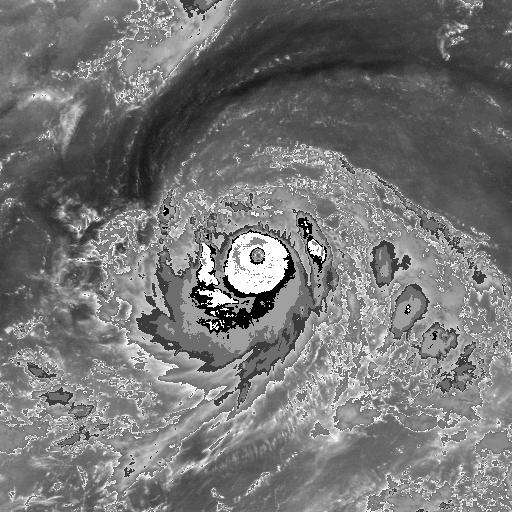
mrbagyo

- Category 5
- Posts: 3614
- Age: 31
- Joined: Thu Apr 12, 2012 9:18 am
- Location: 14.13N 120.98E
- Contact:
Re: Discussion of Intense Tropical Cyclones
Had there been any typhoons before that got sampled by recon via SFMR?
It appears the technique is quite good in locating the vmax near the surface.
Btw, I have another past typhoon that looked very good in BD.
You may estimate the intensity then I'll reveal the best track. Lol
BD image at peak based on best track
BD Loop
It appears the technique is quite good in locating the vmax near the surface.
Btw, I have another past typhoon that looked very good in BD.
You may estimate the intensity then I'll reveal the best track. Lol
BD image at peak based on best track
BD Loop
0 likes
The posts in this forum are NOT official forecast and should not be used as such. They are just the opinion of the poster and may or may not be backed by sound meteorological data. They are NOT endorsed by any professional institution or storm2k.org. For official information, please refer to RSMC, NHC and NWS products.

Re: Discussion of Intense Tropical Cyclones
mrbagyo wrote:Had there been any typhoons before that got sampled by recon via SFMR?
It appears the technique is quite good in locating the vmax near the surface.
Btw, I have another past typhoon that looked very good in BD.
You may estimate the intensity then I'll reveal the best track. Lol
BD image at peak based on best track
BD Loop
I tried to find the storm's name but I can't. I guess the peak intensity in the best track is 130-135 knot. (Sorry, my english is not good)
0 likes
Re: Discussion of Intense Tropical Cyclones
mrbagyo wrote:Had there been any typhoons before that got sampled by recon via SFMR?
It appears the technique is quite good in locating the vmax near the surface.
Btw, I have another past typhoon that looked very good in BD.
You may estimate the intensity then I'll reveal the best track. Lol
BD image at peak based on best track
BD Loop
Is it Super Typhoon Megi?
G E N E R A L I N F O R M A T I O N
----------------------------------------------------------------------------
| Mission Type | Hurricane |
| Tasking | three fixes and racetrack into SuperTyphoon Megi |
| Mission ID | 5304 0830W MEGI |
| Departure Base/Time | PGUA 10/17/10 06:55 |
| Arrival Base/Time | PGUA 10/17/10 19:16 |
| Flight Time | 12.4 hours |
----------------------------------------------------------------------------
F I X P O I N T S
----------------------------------------------------------------------------
| | Latitude | Longitude | SLP | MWnd | SWS | |
| Date/Time | dd mm N/S | ddd mm E/W | mb | kt | kt | Hurricane |
|----------------------------------------------------------------------------|
| 10/17/10 11:15 | 18 06 N | 125 14 E | 895 | 170 | 163 | X |
| 10/17/10 12:06 | 18 01 N | 125 05 E | 893 | 190 | 152 | X |
| 10/17/10 13:05 | 17 57 N | 124 55 E | 890 | 177 | 165 | X |
----------------------------------------------------------------------------
890 mb and 200 mph found in Megi.
As they penetrated Megi's eyewall, the Hurricane Hunters performed the standard practice of maintaining a constant "pressure altitude"--the altitude one would expect to find a 700 mb pressure at in an atmosphere at standard conditions. In order to maintain a constant pressure altitude of 10,000 feet, the aircraft was forced to descend 3,000 feet in altitude as it entered Megi's eye. The aircraft entered the eye at 7,000 feet, so the pressure in Megi's eye was what one would normally find at an altitude 3,000 feet higher in the atmosphere. The aircraft recorded a remarkable increase in temperature of 12°C (22°F) as it crossed from the eyewall into the warm eye of Megi. A 12°C rise in eye temperature is extraordinarily rare in a tropical cyclone. Equally noteworthy were Megi's winds. The Hurricane Hunters measured winds at flight level of 220 mph, which normally translates to a surface wind speed of 198 mph, using the standard 10% reduction. The SFMR surface wind measurement instrument recorded surface winds of 186 mph in regions where heavy rain was not contaminating the measurement, but found surface winds of 199 mph in one region of heavy rain. Now, this measurement is considered contaminated by rain, but at very high wind speeds, the contamination effect is less important than at lower hurricane wind speeds, and it is possible than Megi's surface winds reached sustained speeds of 200 mph.
0 likes
Remember, all of my post aren't official. For official warnings and discussions, Please refer to your local NWS products...
NWS for the Western Pacific
https://www.weather.gov/gum/
NWS for the Western Pacific
https://www.weather.gov/gum/
-
doomhaMwx

- Category 5
- Posts: 2398
- Age: 25
- Joined: Tue Apr 18, 2017 4:01 am
- Location: Baguio/Benguet, Philippines
- Contact:
Re: Discussion of Intense Tropical Cyclones
1900hurricane wrote:If anything, SATCON has actually come into even tighter agreement with the recon verified intensities for Hurricane Irma. One storm does not make or break an intensity method, but this could be a big win for this particular remote sensing method.
https://twitter.com/1900hurricane/status/906356931559903232
SATCON for Hurricane Jose also close to the measurements taken by recon...
1 likes
Like my content? Consider giving a tip.
Re: Discussion of Intense Tropical Cyclones
One record i found for Irma is somewhat interesting.
How can they say that? Irma had recon and Haiyan didn't but had more impressive cloud tops wise, ADT and dvorak wise, and for a longer time period. I know alot of typhoons that was more impressive than she.
It's the other way around for Irma. It led all dvorak and ADT and never reached 7.5 by more than a day.
Talk about fair competition it isn't.
- 185 mph max winds for 37 hours – the longest any cyclone around the globe has
maintained that intensity on record. The previous record was Haiyan in the NW
Pacific at 24 hours
How can they say that? Irma had recon and Haiyan didn't but had more impressive cloud tops wise, ADT and dvorak wise, and for a longer time period. I know alot of typhoons that was more impressive than she.
It's the other way around for Irma. It led all dvorak and ADT and never reached 7.5 by more than a day.
Talk about fair competition it isn't.
2 likes
Remember, all of my post aren't official. For official warnings and discussions, Please refer to your local NWS products...
NWS for the Western Pacific
https://www.weather.gov/gum/
NWS for the Western Pacific
https://www.weather.gov/gum/
-
mrbagyo
- Category 5
- Posts: 3614
- Age: 31
- Joined: Thu Apr 12, 2012 9:18 am
- Location: 14.13N 120.98E
- Contact:
Re: Discussion of Intense Tropical Cyclones
styzeb wrote:mrbagyo wrote:Had there been any typhoons before that got sampled by recon via SFMR?
It appears the technique is quite good in locating the vmax near the surface.
Btw, I have another past typhoon that looked very good in BD.
You may estimate the intensity then I'll reveal the best track. Lol
BD image at peak based on best track
BD Loop
I tried to find the storm's name but I can't. I guess the peak intensity in the best track is 130-135 knot. (Sorry, my english is not good)
Your guess is correct and I think the typhoon was underestimated by JTWC - it's at least T7.0 for many hours and yet it didnt get upgraded to a cat 5. Heck it even managed to pull a full CMG ring before warming during sunrise - also of note is the temperature of the eye - it was warm medium grey.
This typhoon is Typhoon Dinah 1987- it peaked at "only" 130 knots. She came right after the end of recon in WPAC.
1 likes
The posts in this forum are NOT official forecast and should not be used as such. They are just the opinion of the poster and may or may not be backed by sound meteorological data. They are NOT endorsed by any professional institution or storm2k.org. For official information, please refer to RSMC, NHC and NWS products.
Re: Discussion of Intense Tropical Cyclones
mrbagyo wrote:styzeb wrote:mrbagyo wrote:Had there been any typhoons before that got sampled by recon via SFMR?
It appears the technique is quite good in locating the vmax near the surface.
Btw, I have another past typhoon that looked very good in BD.
You may estimate the intensity then I'll reveal the best track. Lol
BD image at peak based on best track
BD Loop
I tried to find the storm's name but I can't. I guess the peak intensity in the best track is 130-135 knot. (Sorry, my english is not good)
Your guess is correct and I think the typhoon was underestimated by JTWC - it's at least T7.0 for many hours and yet it didnt get upgraded to a cat 5. Heck it even managed to pull a full CMG ring before warming during sunrise - also of note is the temperature of the eye - it was warm medium grey.
This typhoon is Typhoon Dinah 1987- it peaked at "only" 130 knots. She came right after the end of recon in WPAC.
Just reading this thread. it looks like JTWC has underestimated alot of typhoons during post recon.
0 likes
Remember, all of my post aren't official. For official warnings and discussions, Please refer to your local NWS products...
NWS for the Western Pacific
https://www.weather.gov/gum/
NWS for the Western Pacific
https://www.weather.gov/gum/
Re: Discussion of Intense Tropical Cyclones
What do you guys think of Super Typhoon Nancy in 1961?
The WPAC have had these powerful +160 knot or higher TC for a very long time. At the time, it was thought to be unreliable because 165 knot was deem the ultimate peak for all TC's and cannot be passed. Then came the closest rival to the WPAC from the WHEM, Hurricane Patricia...
A reconnaissance aircraft flying into the typhoon near its peak intensity on September 12 determined Nancy's one-minute sustained winds to be 185 knots (215 mph; 345 km/h). If these values are reliable, they would be the highest wind speeds ever measured in a tropical cyclone.[5] However, it was later determined that measurements and estimations of wind speeds from the 1940s to 1960s were excessive. Thus, Nancy's winds may actually be lower than its official best-track value.[5] In 2016, reanalysis of Hurricane Patricia noted that the storm had 215 mph (345 km/h) sustained winds, which ties Nancy and is the highest sustained winds in the Western Hemisphere.[6]
Although the Saffir–Simpson hurricane wind scale (SSHWS) didn't exist at the time, Nancy would have been a Category 5 equivalent for a total of five and a half days (or 132 hours), assuming the windspeed data is reliable. This is a record for the Northern Hemisphere and more than a day longer than the next-highest system, 1962's Typhoon Karen.
The WPAC have had these powerful +160 knot or higher TC for a very long time. At the time, it was thought to be unreliable because 165 knot was deem the ultimate peak for all TC's and cannot be passed. Then came the closest rival to the WPAC from the WHEM, Hurricane Patricia...
0 likes
Remember, all of my post aren't official. For official warnings and discussions, Please refer to your local NWS products...
NWS for the Western Pacific
https://www.weather.gov/gum/
NWS for the Western Pacific
https://www.weather.gov/gum/
-
1900hurricane
- Category 5
- Posts: 6044
- Age: 32
- Joined: Fri Feb 06, 2015 12:04 pm
- Location: Houston, TX
- Contact:
Re: Discussion of Intense Tropical Cyclones
A complete dataset on Nancy '61 is somewhat hard to come by since it occurred prior to the satellite era, but all the indications that I can see tell me it was an exceptionally intense system. WPac recon from the JTWC report showed that it maintained a pressure below 900 mb for about 2.5 days, and notes on eye size seem to indicate that it even went through eyewall replacement during that time based on the eye size increasing from 6 to 25 (statute?) miles. Additionally, if you roughly treat the time when the pressure is below 920 mb as category 5 time, it comes out to about 5 days, which matches up fairly well with the existing best track, which has 5.5.
I haven't found access to Nancy '61's wind radii or environmental pressures, so I can't run KZC for the system, but a reanalysis involving Knaff using KZC yielded a 173 kt Vmax, one of the highest in the study. I don't know if the 185 kt Vmax in best track is the best value, but it certainly still is plausible considering some of the margin for error that still exits with KZC. I am fairly skeptical that Nancy '61 spent 2.75 consecutive days at or above 170 kt though. It should be noted that the radar images from Nancy '61 are some of the best I've seen considering the radar technology from the time.


I haven't found access to Nancy '61's wind radii or environmental pressures, so I can't run KZC for the system, but a reanalysis involving Knaff using KZC yielded a 173 kt Vmax, one of the highest in the study. I don't know if the 185 kt Vmax in best track is the best value, but it certainly still is plausible considering some of the margin for error that still exits with KZC. I am fairly skeptical that Nancy '61 spent 2.75 consecutive days at or above 170 kt though. It should be noted that the radar images from Nancy '61 are some of the best I've seen considering the radar technology from the time.
1 likes
Contract Meteorologist. TAMU & MSST. Fiercely authentic, one of a kind. We are all given free will, so choose a life meant to be lived. We are the Masters of our own Stories.
Opinions expressed are mine alone.
Follow me on Twitter at @1900hurricane : Read blogs at https://1900hurricane.wordpress.com/
Opinions expressed are mine alone.
Follow me on Twitter at @1900hurricane : Read blogs at https://1900hurricane.wordpress.com/
-
supercane4867
- Category 5
- Posts: 4966
- Joined: Wed Nov 14, 2012 10:43 am
Re: Discussion of Intense Tropical Cyclones
Very interesting tweet from Ryan Maue saying that Cyclone Hina of SPAC, which JTWC previously deemed as a CAT4, was reanalyzed to be 170kts by NHC forecaster Chris Landsea.
I really believe Cyclone Monica and a few other SPAC storms could have reached similar intensities as well. I hope more research for these intense TCs will be done in the near future.
https://twitter.com/RyanMaue/status/908740517416009729

I really believe Cyclone Monica and a few other SPAC storms could have reached similar intensities as well. I hope more research for these intense TCs will be done in the near future.
https://twitter.com/RyanMaue/status/908740517416009729
5 likes
Who is online
Users browsing this forum: Hurricaneman, hurricanes1234, NotSparta, pepecool20, revjohn, zzzh and 149 guests