Discussion of Intense Tropical Cyclones

This is the general tropical discussion area. Anyone can take their shot at predicting a storms path.

Moderator: S2k Moderators

Forum rules

The posts in this forum are NOT official forecasts and should not be used as such. They are just the opinion of the poster and may or may not be backed by sound meteorological data. They are NOT endorsed by any professional institution or STORM2K. For official information, please refer to products from the National Hurricane Center and National Weather Service.

Help Support Storm2K
Message
Author
User avatar
euro6208
Category 5
Category 5
Posts: 18547
Joined: Mon Mar 08, 2004 7:50 pm
Location: Guam

Re: Discussion of Intense Tropical Cyclones

#81 Postby euro6208 » Sun Jan 24, 2016 4:38 am

1900hurricane wrote:Speaking of Western Pacific recon, I recently noticed that it has been about the same number of years since recon ended there to now as the years from JTWC's founding to the end of recon. From JTWC's first year in 1959 until recon ended in 1987, five storms had pressures below 880 mb directly recorded (the aforementioned Nora '73, June '75, Rita '78, Tip '79, and Vanessa '84), and one more can be inferred with reasonable confidence (Forrest '83), making six. If we run under the (admittedly unfounded) assumption that we've had about the same number since, which typhoons do you think would join them?

After some thought, my six would be as follows (in chronological order):
Gay '92
Angela '95
Zeb '98
Nida '09
Haiyan '13
Nuri '14
(My next three up would probably be Yuri '91, Dianmu '04, and Vongfong '14)


Seems like those monsters in the recon era occurred every 1-4 years. I wonder how much more should be on the list. 1997 alone had 10 impressive cat 5's.

If we count sub -900mb storms, oh my...
0 likes   
Remember, all of my post aren't official. For official warnings and discussions, Please refer to your local NWS products...

NWS for the Western Pacific

https://www.weather.gov/gum/

User avatar
1900hurricane
Category 5
Category 5
Posts: 6044
Age: 32
Joined: Fri Feb 06, 2015 12:04 pm
Location: Houston, TX
Contact:

Re: Discussion of Intense Tropical Cyclones

#82 Postby 1900hurricane » Thu Feb 04, 2016 11:46 am

The postseason report of Hurricane Patricia has now been released. I think 185 kt/872 mb speaks for itself pretty well.

http://www.nhc.noaa.gov/data/tcr/EP202015_Patricia.pdf
0 likes   
Contract Meteorologist. TAMU & MSST. Fiercely authentic, one of a kind. We are all given free will, so choose a life meant to be lived. We are the Masters of our own Stories.
Opinions expressed are mine alone.

Follow me on Twitter at @1900hurricane : Read blogs at https://1900hurricane.wordpress.com/

User avatar
EquusStorm
Category 5
Category 5
Posts: 1649
Age: 33
Joined: Thu Nov 07, 2013 1:04 pm
Location: Jasper, AL
Contact:

Re: Discussion of Intense Tropical Cyclones

#83 Postby EquusStorm » Fri Feb 05, 2016 12:15 am

The Patricia report has numbers I would only expect to see in overblown disaster movies or apocalyptic fiction. Never in my wildest dreams did I think they would officially indicate that it had gotten THAT intense between advisories, despite many people here suggesting this and satellite imagery suggesting that might've been the case. Still, 872? Phenomenal. Though I could be wrong and we could certainly have an even stronger one pretty much anytime in some basin, thus far this was definitely the tropical cyclone of my lifetime in the way of confirmed intensity.

So glad I stayed up to watch recon come in that fateful night.
0 likes   
Colors of lost purpose on the canvas of irrelevance

Not a meteorologist, in fact more of an idiot than anything. You should probably check with the NHC or a local NWS office for official information.

User avatar
1900hurricane
Category 5
Category 5
Posts: 6044
Age: 32
Joined: Fri Feb 06, 2015 12:04 pm
Location: Houston, TX
Contact:

Re: Discussion of Intense Tropical Cyclones

#84 Postby 1900hurricane » Sun Feb 14, 2016 6:34 pm

Ha, finally got my computer back. :P I do want to say that I'm very happy to see the NHC embracing the Knaff-Zehr-Courtney P/W relationship the way they have lately. Unlike the traditional P/W relationships like the Atkinson-Holliday (often known as the WPac P/W relationship) or Dvorak (Atlantic) relationship, the KZC relationship takes into account multiple variables, making it much more flexible and generally superior to the other P/W relationships. Like many others, I was initially surprised to see the NHC derive the 872 mb estimate at 12Z October 23rd for Hurricane Patricia, but using KZC with all the data at their disposal, it makes a good deal of sense, especially considering how close the recon data was following KZC. Even though basins outside the NHC (and CPHC) don't have the luxury of aircraft reconnaissance, I'd still like to see the other agencies adopt use of KZC using Dvorak/ADT, scatterometer and microwave passes, and other such available data for the inputs. In a similar vein, CIRA has already done a couple of recon-era WPac reanalyses (here and here) using KZC to re-derive maximum winds since many the winds listed in the JTWC best track are either a result of bad estimation or too heavily dependent on Atkinson-Holliday.

Something I also would like to note is that unlike with Patricia, older storms (such as the recon-era WPac storms or even as recently as Hurricane Wilma) didn't have the benefit of having a flexible P/W relationship like KZC to estimate a pressure in between or in the absence of recon flights. Heck, as far as I know, the older dropsondes used when recon was run in the WPac weren't able to record wind data, disallowing any possible surface pressure reductions due to surface winds like we see used today. If Patricia had been sampled using Western Pacific recon practices from the 1970s and 1980s, I highly suspect the lowest pressure in the best track would be 883 mb, which would then be plugged into the Atkinson-Holliday P/W relationship to derive winds of 150 kt. Please note that this isn't a dig on old recon practices, but considering how much our knowledge of tropical cyclones has advanced since those days, it is something that needs to be addressed when comparing a storm like Patricia to storms past.
0 likes   
Contract Meteorologist. TAMU & MSST. Fiercely authentic, one of a kind. We are all given free will, so choose a life meant to be lived. We are the Masters of our own Stories.
Opinions expressed are mine alone.

Follow me on Twitter at @1900hurricane : Read blogs at https://1900hurricane.wordpress.com/

User avatar
1900hurricane
Category 5
Category 5
Posts: 6044
Age: 32
Joined: Fri Feb 06, 2015 12:04 pm
Location: Houston, TX
Contact:

Re: Discussion of Intense Tropical Cyclones

#85 Postby 1900hurricane » Wed Feb 17, 2016 8:57 pm

If anyone is curious, I was able to replicate how the NHC extrapolated the 872 mb for Hurricane Patricia using KZC.

Image
1 likes   
Contract Meteorologist. TAMU & MSST. Fiercely authentic, one of a kind. We are all given free will, so choose a life meant to be lived. We are the Masters of our own Stories.
Opinions expressed are mine alone.

Follow me on Twitter at @1900hurricane : Read blogs at https://1900hurricane.wordpress.com/

User avatar
1900hurricane
Category 5
Category 5
Posts: 6044
Age: 32
Joined: Fri Feb 06, 2015 12:04 pm
Location: Houston, TX
Contact:

Re: Discussion of Intense Tropical Cyclones

#86 Postby 1900hurricane » Tue Sep 13, 2016 9:22 pm

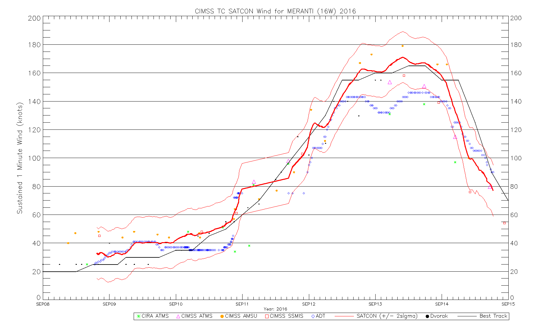
Bumping this particularly for Meranti and the outrageous AMSU and SATCON estimates. The very intense Winston, Fantala, and Nepartak have also occurred since this thread was last active.

Image

Anyone know of any verification scores for SATCON? Meranti is the first case I can remember seeing in which JTWC has deviated so far from the Dvorak Technique without recon data.
0 likes   
Contract Meteorologist. TAMU & MSST. Fiercely authentic, one of a kind. We are all given free will, so choose a life meant to be lived. We are the Masters of our own Stories.
Opinions expressed are mine alone.

Follow me on Twitter at @1900hurricane : Read blogs at https://1900hurricane.wordpress.com/

User avatar
euro6208
Category 5
Category 5
Posts: 18547
Joined: Mon Mar 08, 2004 7:50 pm
Location: Guam

Re: Discussion of Intense Tropical Cyclones

#87 Postby euro6208 » Tue Sep 13, 2016 9:28 pm

1900hurricane wrote:Bumping this particularly for Meranti and the outrageous AMSU and SATCON estimates. The very intense Winston, Fantala, and Nepartak have also occurred since this thread was last active.


Anyone know of any verification scores for SATCON? Meranti is the first case I can remember seeing in which JTWC has deviated so far from the Dvorak Technique without recon data.


If JTWC had followed Satcon entirely, Meranti could have peaked at 185 knots...
0 likes   
Remember, all of my post aren't official. For official warnings and discussions, Please refer to your local NWS products...

NWS for the Western Pacific

https://www.weather.gov/gum/

User avatar
1900hurricane
Category 5
Category 5
Posts: 6044
Age: 32
Joined: Fri Feb 06, 2015 12:04 pm
Location: Houston, TX
Contact:

Re: Discussion of Intense Tropical Cyclones

#88 Postby 1900hurricane » Tue Sep 13, 2016 10:28 pm

euro6208 wrote:
1900hurricane wrote:Bumping this particularly for Meranti and the outrageous AMSU and SATCON estimates. The very intense Winston, Fantala, and Nepartak have also occurred since this thread was last active.


Anyone know of any verification scores for SATCON? Meranti is the first case I can remember seeing in which JTWC has deviated so far from the Dvorak Technique without recon data.


If JTWC had followed Satcon entirely, Meranti could have peaked at 185 knots...


I doubt it. The extreme-most member of the SATCON estimate was the 0950Z AMSU pass, which yielded a 179 kt estimate. I'd probably use that as my hard upper bound for an intensity uncertainty interval. The 165 kt is probably ok, and I would not adjust it any higher, especially considering how much lower subjective Dvorak analysis was. Honestly, I was very surprised to see JTWC give something other than the Dvorak Technique so much clout.
0 likes   
Contract Meteorologist. TAMU & MSST. Fiercely authentic, one of a kind. We are all given free will, so choose a life meant to be lived. We are the Masters of our own Stories.
Opinions expressed are mine alone.

Follow me on Twitter at @1900hurricane : Read blogs at https://1900hurricane.wordpress.com/

CrazyC83
Professional-Met
Professional-Met
Posts: 33393
Joined: Tue Mar 07, 2006 11:57 pm
Location: Deep South, for the first time!

Re: Discussion of Intense Tropical Cyclones

#89 Postby CrazyC83 » Tue Sep 13, 2016 11:42 pm

1900hurricane wrote:
euro6208 wrote:
1900hurricane wrote:Bumping this particularly for Meranti and the outrageous AMSU and SATCON estimates. The very intense Winston, Fantala, and Nepartak have also occurred since this thread was last active.


Anyone know of any verification scores for SATCON? Meranti is the first case I can remember seeing in which JTWC has deviated so far from the Dvorak Technique without recon data.


If JTWC had followed Satcon entirely, Meranti could have peaked at 185 knots...


I doubt it. The extreme-most member of the SATCON estimate was the 0950Z AMSU pass, which yielded a 179 kt estimate. I'd probably use that as my hard upper bound for an intensity uncertainty interval. The 165 kt is probably ok, and I would not adjust it any higher, especially considering how much lower subjective Dvorak analysis was. Honestly, I was very surprised to see JTWC give something other than the Dvorak Technique so much clout.


Using Dvorak alone, 150 kt would have likely been the most reasonable intensity for Meranti. That was based on a mix of 7.0's and 7.5's and CMG mostly but not entirely wrapping around.

Given the range of data, I'd go a touch higher and say 155 kt for its real peak intensity.
0 likes   

User avatar
1900hurricane
Category 5
Category 5
Posts: 6044
Age: 32
Joined: Fri Feb 06, 2015 12:04 pm
Location: Houston, TX
Contact:

Re: Discussion of Intense Tropical Cyclones

#90 Postby 1900hurricane » Wed Sep 14, 2016 9:59 am

CrazyC83 wrote:
1900hurricane wrote:
euro6208 wrote:
If JTWC had followed Satcon entirely, Meranti could have peaked at 185 knots...


I doubt it. The extreme-most member of the SATCON estimate was the 0950Z AMSU pass, which yielded a 179 kt estimate. I'd probably use that as my hard upper bound for an intensity uncertainty interval. The 165 kt is probably ok, and I would not adjust it any higher, especially considering how much lower subjective Dvorak analysis was. Honestly, I was very surprised to see JTWC give something other than the Dvorak Technique so much clout.


Using Dvorak alone, 150 kt would have likely been the most reasonable intensity for Meranti. That was based on a mix of 7.0's and 7.5's and CMG mostly but not entirely wrapping around.

Given the range of data, I'd go a touch higher and say 155 kt for its real peak intensity.

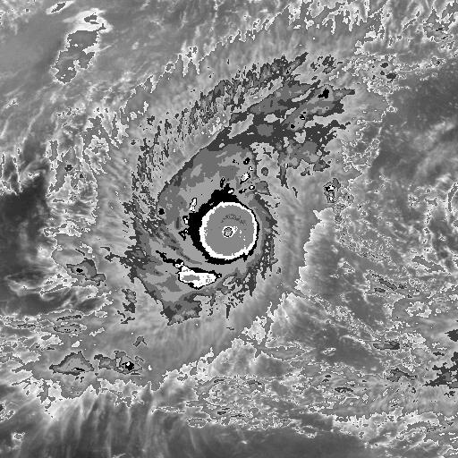
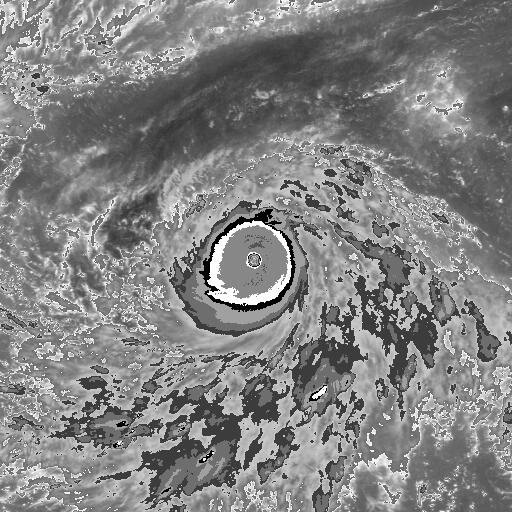
The DT was absolutely a 7.5 for at least 12Z on September 13th. The >20*C eye was embedded in the cold medium grey to a full degree. Certainly there were times where it looked like JTWC was running a little hot on their satellite bulletins, but definitely not between 09Z and 12Z.

Image
0 likes   
Contract Meteorologist. TAMU & MSST. Fiercely authentic, one of a kind. We are all given free will, so choose a life meant to be lived. We are the Masters of our own Stories.
Opinions expressed are mine alone.

Follow me on Twitter at @1900hurricane : Read blogs at https://1900hurricane.wordpress.com/

CrazyC83
Professional-Met
Professional-Met
Posts: 33393
Joined: Tue Mar 07, 2006 11:57 pm
Location: Deep South, for the first time!

Re: Discussion of Intense Tropical Cyclones

#91 Postby CrazyC83 » Wed Sep 14, 2016 10:23 am

1900hurricane wrote:
CrazyC83 wrote:
1900hurricane wrote:
I doubt it. The extreme-most member of the SATCON estimate was the 0950Z AMSU pass, which yielded a 179 kt estimate. I'd probably use that as my hard upper bound for an intensity uncertainty interval. The 165 kt is probably ok, and I would not adjust it any higher, especially considering how much lower subjective Dvorak analysis was. Honestly, I was very surprised to see JTWC give something other than the Dvorak Technique so much clout.


Using Dvorak alone, 150 kt would have likely been the most reasonable intensity for Meranti. That was based on a mix of 7.0's and 7.5's and CMG mostly but not entirely wrapping around.

Given the range of data, I'd go a touch higher and say 155 kt for its real peak intensity.

The DT was absolutely a 7.5 for at least 12Z on September 13th. The >20*C eye was embedded in the cold medium grey to a full degree. Certainly there were times where it looked like JTWC was running a little hot on their satellite bulletins, but definitely not between 09Z and 12Z.

Image


That is clearly T7.5 (I was too busy with school work to focus there for a bit), so maybe 160 kt is the best guess for peak intensity at that time.
0 likes   

User avatar
1900hurricane
Category 5
Category 5
Posts: 6044
Age: 32
Joined: Fri Feb 06, 2015 12:04 pm
Location: Houston, TX
Contact:

Re: Discussion of Intense Tropical Cyclones

#92 Postby 1900hurricane » Thu Sep 15, 2016 8:35 pm

I actually have a number of thoughts I've recently developed that I'd like to express regarding the estimation of very intense tropical cyclones. Much of this has to do with JTWC's intensity estimates for Super Typhoon Meranti, but it also goes beyond that as well.

First off, I want to say that I appreciate JTWC trying to expand their suite of intensity analysis beyond the Dvorak Technique for the most intense storms. The Dvorak Technique is certainly has the most data and verification behind it, but as stated earlier in this thread, the intensities at the upper end of the scale are a little more uncertain, and is generally thought to underestimate the most intense storms to some degree. Data from storms like Rita '05, Megi '10, and Patricia '15 seem to support that. (Random note, Megi and Meranti actually had very similar CDOs near peak intensity). That's just the nature of the technique due to the limited number of cases available to Vernon Dvorak when he completed the framework of the technique. In Meranti's case, DTs of 7.5 would only yield an intensity estimate of 155 kt. However, between 06Z and 18Z on September 13th, all intensity estimates that were reliant on microwave data instead of IR (AMSU, ATMS, and SSMIS) ranged between 154 kt to 179 kt, generally higher than the DTs, and sometimes considerably. JTWC took note of this and factored it into their intensity estimates, which is fine with me.

Second, while I appreciate JTWC using a wider range of intensity estimates with the more intense storms, they've opened up a whole new can of worms with it: constraint rules. The big question for me is as follows: should a tropical cyclone whose intensity was derived from multiple members of an intensity analysis suite be limited by the same Dvorak constraints that a tropical cyclone whose intensity is derived primarily from the Dvorak Technique would be subject to? Honestly, I'm not sure I have a good answer, and research may need to be done in this area. In Meranti's case, I personally suspect that JTWC used the Dvorak constraints to hold Meranti at too high of an intensity beginning on 00Z of September 14th. The storm had begun to degrade on IR by that point, and the SATCON members also began to plummet by then, leaving JTWC outside the +2 sigma confidence interval. However, it could be argued that JTWC should have broken all Dvorak constraints anyway due to the interaction with Taiwan.

Third, JTWC has stepped beyond a basic wind to pressure relationship! This personally is exciting to me since they have for so long just plugged their intensity estimates into Atkinson-Holliday or some other simple wind to pressure relationship to output a (oftentimes probably very inaccurate) pressure. They don't appear to be very good at it yet, especially when they go back and revise an intensity up or down (see trackfile for Meranti, particularly 12Z September 13th), but it's a step in the right direction.

Last for now, but I do not like how ADT 8.2.1 handles the intense tropical cyclones in the Tropical Western Pacific at all. ADT was a low outlier for Meranti, often sitting well below the -2 sigma SATCON intensity estimates and only just clipping above 140 kt. On the other hand, ADT 8.2.1 seems to run a little hot in the Tropical Eastern Pacific. The most notable case in that basin belongs to Patricia '15, where it constantly spit out values well above 8.0 despite poor eye temperature inputs. It is true that it ended up being fairly close to the intensity inferred by recon measurements, but I do question the methodology. Anyway, it is obvious that ADT 8.2.1 is calibrated differently for the Pacific on either side of the International Dateline, which is odd to me. This came to be an issue in the intensity analysis for Winston this year. Upon crossing the International Dateline, the raw Ts dropped .7 points (from 8.0 to 7.3) for no other reason than crossing the International Dateline. That just doesn't seem like sound intensity analysis. Either the algorithm is underestimating to the west, overestimating to the east, or both.
2 likes   
Contract Meteorologist. TAMU & MSST. Fiercely authentic, one of a kind. We are all given free will, so choose a life meant to be lived. We are the Masters of our own Stories.
Opinions expressed are mine alone.

Follow me on Twitter at @1900hurricane : Read blogs at https://1900hurricane.wordpress.com/

NotoSans
Category 5
Category 5
Posts: 1366
Age: 24
Joined: Sun Sep 27, 2015 1:15 am
Location: Hong Kong
Contact:

Re: Discussion of Intense Tropical Cyclones

#93 Postby NotoSans » Fri Sep 16, 2016 12:14 am

JTWC has been referencing objective intensity estimates (particularly SATCON) since early this year. But I realize that they are really inconsistent when it comes to intensity estimates, and it really depends on the forecaster. Some forecasters give a higher weight to the objective aids but some are just blindly following subjective Dvorak estimates (this can be reflected in their prognostic reasoning). This can also help explain the large discrepency between the estimates for Nepartak and Meranti. Of course it is a good step for them to start having a look at other data, but it's necessary for them to develop a consistent operational standard in order to provide better intensity estimates.

For the pressure estimates, some other people suggest that JTWC may have started to use the KZC pressure relationship to derive the estimates. Again, it is a good step for them but, again, consistency may be a problem.
1 likes   
Personal Forecast Disclaimer:
The posts in this forum are NOT official forecast and should not be used as such. They are just the opinion of the poster and may or may not be backed by sound meteorological data. They are NOT endorsed by any professional institution or storm2k.org. For official information, please refer to RSMC and NWS products.

User avatar
Ptarmigan
Category 5
Category 5
Posts: 5272
Joined: Wed Aug 16, 2006 9:06 pm

Re: Discussion of Intense Tropical Cyclones

#94 Postby Ptarmigan » Fri Sep 16, 2016 10:09 pm

1900hurricane wrote:Speaking of Western Pacific recon, I recently noticed that it has been about the same number of years since recon ended there to now as the years from JTWC's founding to the end of recon. From JTWC's first year in 1959 until recon ended in 1987, five storms had pressures below 880 mb directly recorded (the aforementioned Nora '73, June '75, Rita '78, Tip '79, and Vanessa '84), and one more can be inferred with reasonable confidence (Forrest '83), making six. If we run under the (admittedly unfounded) assumption that we've had about the same number since, which typhoons do you think would join them?

After some thought, my six would be as follows (in chronological order):
Gay '92
Angela '95
Zeb '98
Nida '09
Haiyan '13
Nuri '14
(My next three up would probably be Yuri '91, Dianmu '04, and Vongfong '14)


How about Ivan and Joan of 1997.
0 likes   

User avatar
Ptarmigan
Category 5
Category 5
Posts: 5272
Joined: Wed Aug 16, 2006 9:06 pm

Re: Discussion of Intense Tropical Cyclones

#95 Postby Ptarmigan » Fri Sep 16, 2016 10:16 pm

I notice in the Northern Hemisphere, many of the most intense tropical cyclones on record happen in October.

Atlantic-Wilma
East Pacific-Patricia
West Pacific-Tip
North Indian Ocean-1999 Odisha Cyclone

I always wondered why.
0 likes   

User avatar
euro6208
Category 5
Category 5
Posts: 18547
Joined: Mon Mar 08, 2004 7:50 pm
Location: Guam

Re: Discussion of Intense Tropical Cyclones

#96 Postby euro6208 » Sat Sep 17, 2016 3:04 am

Kinda funny to see Obsolete Tip from 37 years ago still considered one of the top in the basin and globally.

Many typhoons since 1987 have already passed Tip. Higher Dvorak and much more better satellite presentation.
0 likes   
Remember, all of my post aren't official. For official warnings and discussions, Please refer to your local NWS products...

NWS for the Western Pacific

https://www.weather.gov/gum/

User avatar
1900hurricane
Category 5
Category 5
Posts: 6044
Age: 32
Joined: Fri Feb 06, 2015 12:04 pm
Location: Houston, TX
Contact:

Re: Discussion of Intense Tropical Cyclones

#97 Postby 1900hurricane » Sat Sep 17, 2016 9:18 am

Ptarmigan wrote:
1900hurricane wrote:Speaking of Western Pacific recon, I recently noticed that it has been about the same number of years since recon ended there to now as the years from JTWC's founding to the end of recon. From JTWC's first year in 1959 until recon ended in 1987, five storms had pressures below 880 mb directly recorded (the aforementioned Nora '73, June '75, Rita '78, Tip '79, and Vanessa '84), and one more can be inferred with reasonable confidence (Forrest '83), making six. If we run under the (admittedly unfounded) assumption that we've had about the same number since, which typhoons do you think would join them?

After some thought, my six would be as follows (in chronological order):
Gay '92
Angela '95
Zeb '98
Nida '09
Haiyan '13
Nuri '14
(My next three up would probably be Yuri '91, Dianmu '04, and Vongfong '14)


How about Ivan and Joan of 1997.

Ivan and Joan were both very intense and probably fully deserving of their 160 kt intensities. However, I would rank then below the nine storms above. I do believe Ivan and Joan '97 are the only storms to ever coexist at such high intensities. The BD IR images of them below are both from 09Z on October 17th. Ivan is on the left, and Joan is on the right.

Image Image

The images actually overlap the same area a little, so they could actually probably be stitched together.
0 likes   
Contract Meteorologist. TAMU & MSST. Fiercely authentic, one of a kind. We are all given free will, so choose a life meant to be lived. We are the Masters of our own Stories.
Opinions expressed are mine alone.

Follow me on Twitter at @1900hurricane : Read blogs at https://1900hurricane.wordpress.com/

User avatar
1900hurricane
Category 5
Category 5
Posts: 6044
Age: 32
Joined: Fri Feb 06, 2015 12:04 pm
Location: Houston, TX
Contact:

Re: Discussion of Intense Tropical Cyclones

#98 Postby 1900hurricane » Sat Sep 17, 2016 9:34 am

Ptarmigan wrote:I notice in the Northern Hemisphere, many of the most intense tropical cyclones on record happen in October.

Atlantic-Wilma
East Pacific-Patricia
West Pacific-Tip
North Indian Ocean-1999 Odisha Cyclone

I always wondered why.

The Hadley Cell retreats back towards the tropics in the fall. While it doesn't extend as far north, it also gets deeper, and the tropopause gets colder. With ocean waters still warm in October, maximum potential intensity actually increases deeper in the tropics. Especially in the Tropical Western Pacific, where storms will form south of 10*N fairly often that time of year, the strongest storms of the year will often exist in October or November. I like to refer to the two months in the WPac as Super Typhoon Season. In the Atlantic (and sometimes the Tropical Eastern Pacific too), incipient disturbances that develop the very intense storms are more rare, and South and Central America limit how far south into a deep Hadley cell storms can emerge from.

For the North Indian Ocean, shear between the southwest monsoon and tropical easterly jet generally shuts down the basin for several months during the summer. Once the monsoon begins changing in the fall though, the basin reopens for tropical development.
1 likes   
Contract Meteorologist. TAMU & MSST. Fiercely authentic, one of a kind. We are all given free will, so choose a life meant to be lived. We are the Masters of our own Stories.
Opinions expressed are mine alone.

Follow me on Twitter at @1900hurricane : Read blogs at https://1900hurricane.wordpress.com/

User avatar
euro6208
Category 5
Category 5
Posts: 18547
Joined: Mon Mar 08, 2004 7:50 pm
Location: Guam

Re: Discussion of Intense Tropical Cyclones

#99 Postby euro6208 » Fri Sep 23, 2016 5:58 am

I think one typhoon that's been overlooked was STY June from 1975.

Pressure recorded was 875 near the eyewall and one respectable meteorologist who monitored the flight and a member of storm2k said it should have been 10 mb lower as the plane had to maneuver and missed it' center in it's 3 mile eye.

FORGET about obsolete Tip.

WOW. I can't believe recon and meteorology missing out on these intense typhoons over the years and although June was recon, it was underestimated. SAD.

Too bad it's in the other side of the globe where storms there are mediocre at best.
0 likes   
Remember, all of my post aren't official. For official warnings and discussions, Please refer to your local NWS products...

NWS for the Western Pacific

https://www.weather.gov/gum/

User avatar
1900hurricane
Category 5
Category 5
Posts: 6044
Age: 32
Joined: Fri Feb 06, 2015 12:04 pm
Location: Houston, TX
Contact:

Re: Discussion of Intense Tropical Cyclones

#100 Postby 1900hurricane » Fri Sep 23, 2016 8:38 pm

euro6208 wrote:I think one typhoon that's been overlooked was STY June from 1975.

Pressure recorded was 875 near the eyewall and one respectable meteorologist who monitored the flight and a member of storm2k said it should have been 10 mb lower as the plane had to maneuver and missed it' center in it's 3 mile eye..

June was discussed earlier in the thread already (first two pages). Even if the dropsonde didn't hit the absolute lowest pressure, the 700 mb flight level heights don't support a storm as strong as Tip. I do believe that it is a pretty clear second as far as 700 mb height is concerned though. As far as I know, Tip '79 and June '75 are the only storms in which a 700 mb height below 2000 meters was recorded.
0 likes   
Contract Meteorologist. TAMU & MSST. Fiercely authentic, one of a kind. We are all given free will, so choose a life meant to be lived. We are the Masters of our own Stories.
Opinions expressed are mine alone.

Follow me on Twitter at @1900hurricane : Read blogs at https://1900hurricane.wordpress.com/


Return to “Talkin' Tropics”

Who is online

Users browsing this forum: No registered users and 40 guests