I also noticed that it seems like these intense tropical cyclones behave differently than your average category 5 storm. They seem to be able to hold their intensity longer and go through EWRCs very quickly and efficiently. Both Haiyan and Patricia were able to hold their small eye and very cold cloud tops until land interaction.
Which storm do you all think was the most powerful in the world? Was it Tip or perhaps Gay, Angela, June, or Patricia?
Discussion of Intense Tropical Cyclones
Moderator: S2k Moderators
Forum rules

The posts in this forum are NOT official forecasts and should not be used as such. They are just the opinion of the poster and may or may not be backed by sound meteorological data. They are NOT endorsed by any professional institution or STORM2K. For official information, please refer to products from the National Hurricane Center and National Weather Service.
-
galaxy401

- Category 5

- Posts: 2299
- Age: 28
- Joined: Sat Aug 25, 2012 9:04 pm
- Location: Casa Grande, Arizona
Re: Intense Tropical Cyclone Discussion
0 likes
Got my eyes on moving right into Hurricane Alley: Florida.
-
1900hurricane

- Category 5
- Posts: 6044
- Age: 32
- Joined: Fri Feb 06, 2015 12:04 pm
- Location: Houston, TX
- Contact:
Re: Intense Tropical Cyclone Discussion
supercane4867 wrote:1900hurricane wrote:Yellow Evan wrote:Recon from June was dropped in the eyewall and recorded a pressure of 876mbar if memory serves correct. The pressure in the eye is presumed to have been lower.
I've seen that stated here before, but I could never track down a reliable source. If true, it could lend some credence to that line of thought, but until then, I'd be more inclined to go with the 700 mb height.
From JTWC annual report
The pressure could've been a few mbs lower depends on the exact location of drop, but I highly doubt it was lower than Tip's.

Ahh, yes I have seen that then (must have just missed it while looking at that JTWC report earlier today). Yeah, it could have been a few millibars lower, but near the eyewall is slightly different than in the eyewall. Still also think Tip is the stronger of the two.
0 likes
Contract Meteorologist. TAMU & MSST. Fiercely authentic, one of a kind. We are all given free will, so choose a life meant to be lived. We are the Masters of our own Stories.
Opinions expressed are mine alone.
Follow me on Twitter at @1900hurricane : Read blogs at https://1900hurricane.wordpress.com/
Opinions expressed are mine alone.
Follow me on Twitter at @1900hurricane : Read blogs at https://1900hurricane.wordpress.com/
-
WeatherGuesser
- Category 5
- Posts: 2672
- Joined: Tue Jun 29, 2010 6:46 am
Re: Intense Tropical Cyclone Discussion
One thing I've noticed here and in other threads is that people can't even agree on what 'intense' is.
Wind speed?
Pressure?
At what level?
At what distance from the core?
As measured by who and by what means?
Estimated by satellite vs. measured by something, even a bouy.
Wind speed?
Pressure?
At what level?
At what distance from the core?
As measured by who and by what means?
Estimated by satellite vs. measured by something, even a bouy.
0 likes
Re: Intense Tropical Cyclone Discussion
galaxy401 wrote:I also noticed that it seems like these intense tropical cyclones behave differently than your average category 5 storm. They seem to be able to hold their intensity longer and go through EWRCs very quickly and efficiently. Both Haiyan and Patricia were able to hold their small eye and very cold cloud tops until land interaction.
Which storm do you all think was the most powerful in the world? Was it Tip or perhaps Gay, Angela, June, or Patricia?
I believe Patricia reached its extreme intensity due to a favorable trough interaction. It was not underneath the anti-cyclone. The upper high was displaced well east of the eye. It was being pulled by the trough, and I believe the interaction initially was such that there was no shear, only outflow enhancement. As Patricia approached the coast, it was sheared causing the rapid weakening before landfall.
My suspicion is that most extreme storms with a pressure had trough enhancement. Haiyan likely did not have a pressure as low as Patricia (it may have been higher than Megi's as well), though it likely had the highest winds of any TC because of the fact that there was a strong ridge just north of Haiyan that was sending west at 20 kts. I still think Haiyan had winds around 185 kts at landfall (and Guiuan did NOT get those winds, Haiyan was that small that those winds remained just offshore)
0 likes
-
supercane4867
- Category 5
- Posts: 4966
- Joined: Wed Nov 14, 2012 10:43 am
Re: Intense Tropical Cyclone Discussion
WeatherGuesser wrote:One thing I've noticed here and in other threads is that people can't even agree on what 'intense' is.
Wind speed?
Pressure?
At what level?
At what distance from the core?
As measured by who and by what means?
Estimated by satellite vs. measured by something, even a bouy.
Personally I think wind speed best expresses how 'intense' a storm is.
However pressure is more widely accepted because of measurability. It's literally impossible to measure the maximum wind speed because wind data we get directly at surface mostly come from dropsondes which only represent small portions of eyewall
0 likes
-
Yellow Evan

- Professional-Met

- Posts: 15951
- Age: 25
- Joined: Fri Jul 15, 2011 12:48 pm
- Location: Henderson, Nevada/Honolulu, HI
- Contact:
Re: Intense Tropical Cyclone Discussion
supercane4867 wrote:Honestly I really hate the Dvorak technique now, especially those of JTWC and SAB. While low-cost to forecasting weak or mid-strength storms in areas where recon is not available, it’s a complete crap when comes to determine the actual intensity of intense hurricane. There are many unsolved problems even with recon (fl to sfc wind relationship, reliability of high SFMR winds etc.). How can we just take two set of satellite image and say which one is stronger? Recon for strong storms in the past ten years include Wilma, Felix, Megi, and Patricia have revealed how little we know about TC windspeeds. Although currently no better technique is introduced, IMO there're more things we need to keep in mind when looking at Dvorak numbers.
Dvorak isn't that bad when it comes to Cat 1/2/3 hurricane and is okay when it comes to tropical storms, but it definitely has a low bias when it comes Category 4 and 5's. Still, it's a good starting point for determining intensity, but other stuff like ADT, microwave, and storm symmetry need to be factored in IMO and be adjusted upward accordingly.
0 likes
-
mrbagyo

- Category 5
- Posts: 3614
- Age: 31
- Joined: Thu Apr 12, 2012 9:18 am
- Location: 14.13N 120.98E
- Contact:
Re: Intense Tropical Cyclone Discussion
Just wanna add another underrated tropical cyclone that everyone seems to forgot.
Typhoon Muifa of 2011 which explosively intensified from 60knot tropical storm to "140 knot" supertyphoon (accdg. to JTWC) within 24 hours.
It also had that perfect ring of -80 CDO with a tiny eye and a very large moisture envelope.
Haha, i can still remember some members here lose their mind when it EIRed, some compared it to Tip while others suggested that it could have been stronger.
0 likes
The posts in this forum are NOT official forecast and should not be used as such. They are just the opinion of the poster and may or may not be backed by sound meteorological data. They are NOT endorsed by any professional institution or storm2k.org. For official information, please refer to RSMC, NHC and NWS products.
-
1900hurricane
- Category 5
- Posts: 6044
- Age: 32
- Joined: Fri Feb 06, 2015 12:04 pm
- Location: Houston, TX
- Contact:
Re: Intense Tropical Cyclone Discussion
Another storm I'd say could belong in the conversation with the elite-most tropical cyclones is Super Typhoon Dianmu of 2004. Like some of the others mentioned, it too seems to have the winning formula of developing out of a monsoon trough and putting together a small and intense core surrounded by a large CDO characterized by temps below -80*C, allowing the system to explosively intensify. Perhaps working against it having a pressure in Tip's ballpark are slightly higher background pressures than some of the other cases, but that may have been mitigated some by the sprawling circulation that surrounds the tight core. JTWC took Dianmu all the way up to 155 kt, which is about as high as they will go nowadays (Haiyan notwithstanding) barring something like recon, but I wouldn't be surprised if it was stronger than even that.

0 likes
Contract Meteorologist. TAMU & MSST. Fiercely authentic, one of a kind. We are all given free will, so choose a life meant to be lived. We are the Masters of our own Stories.
Opinions expressed are mine alone.
Follow me on Twitter at @1900hurricane : Read blogs at https://1900hurricane.wordpress.com/
Opinions expressed are mine alone.
Follow me on Twitter at @1900hurricane : Read blogs at https://1900hurricane.wordpress.com/
-
terstorm1012

- S2K Supporter

- Posts: 1313
- Age: 42
- Joined: Fri Sep 10, 2004 5:36 pm
- Location: Millersburg, PA
Re: Intense Tropical Cyclone Discussion
Alyono, that is a very interesting hypothesis about Patricia, and I hope someone takes notice of it.
0 likes
my posts in this forum are NOT official forecast and should not be used as such. They are just my opinion (to which I welcome challenges!) and may or may not be backed by sound meteorological data. They are NOT endorsed by any professional institution or storm2k.org. For official information, please refer to the NHC and NWS products
-
Dave C
- S2K Supporter
- Posts: 868
- Joined: Thu Sep 04, 2003 4:36 pm
- Location: Middleboro, Mass.(midway between Cape Cod and Boston)
Re: Intense Tropical Cyclone Discussion
That outflow band on the west side of Patricia was insane! Definitely linked and pulled way the heck north of it. I remember super typhoon Keith in 1997 had a long outflow band that had been caught by the westerlies flying by to it's north.
0 likes
-
SouthDadeFish

- Professional-Met
- Posts: 2835
- Joined: Thu Sep 23, 2010 2:54 pm
- Location: Miami, FL
- Contact:
Re: Intense Tropical Cyclone Discussion
Alyono, can you find any estimates of wind shear > 20 knots prior to the landfall of Hurricane Patricia? CIMSS shows only a max of 20 knots right at 00Z on 10/24. I agree that the upper tropospheric trough benefitted Patricia by providing an anticyclonic outflow jet.
Also, I think it should be pointed out that Dvorak estimates are only as good as the satellite data provided to them. One of the issues with Dvorak estimates for Patricia, is that the satellite angle did not allow an accurate reading of the eye temperature because of the small size of the eye, but also because of the angle of the satellite relative to the storm. I have heard the polar orbiting satellites measured a much warmer eye temperature in Patricia (24.4 C).
Thus, I think good candidates for being underestimated are storms with small eyes, and those that are relatively far from the longitude the geostationary satellite is anchored to.
0 likes
-
Yellow Evan
- Professional-Met
- Posts: 15951
- Age: 25
- Joined: Fri Jul 15, 2011 12:48 pm
- Location: Henderson, Nevada/Honolulu, HI
- Contact:
Re: Intense Tropical Cyclone Discussion
Looking at the Muifa and Dianmu pictures above, yes, I see the similarities with Wilma/Patricia. They were definitely Category 5's, and if I had to guess, I'd say 155ish for Muifa and 160-165 knots for Dianmu.
0 likes
-
supercane4867
- Category 5
- Posts: 4966
- Joined: Wed Nov 14, 2012 10:43 am
Re: Intense Tropical Cyclone Discussion
The problem with Muifa is that it started to weaken just after rapidly intensified, which did not sustain the impressive satellite presentation long enough as typical 150kt+ storms do.
It's clearly at least a low end Cat.5, but I won't go too far beyond that.
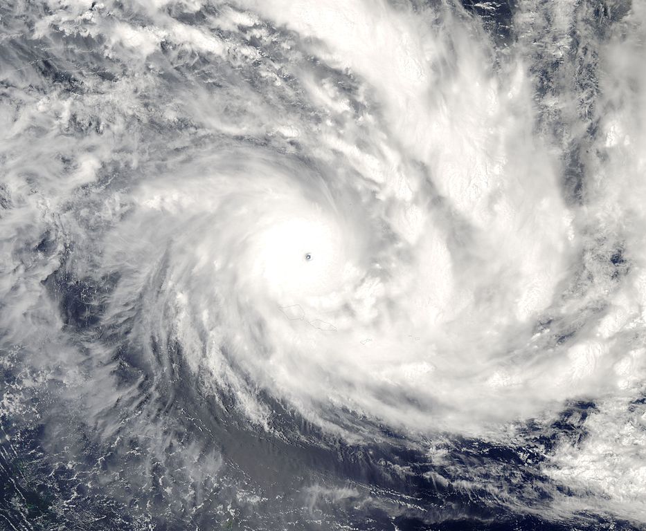
I'd also like to present Cyclone Olaf of 2005. It's basically a SPAC version of Dianmu with the most perfect structure ever observed in southern hemisphere besides Monica. The cyclone undergone a phase of rapid intensification under extreme favorable conditions consisting of 31°C SSTs with low shear and strong diffluence aloft. MODIS imagery indicate the eye is well over 20°C and is surrounded by insanely cold CDO. A barometric pressure of 931mb was recorded on an island of American Samoa when Olaf passed more than 25km to its east after significantly weakened. It's possible the central pressure went as low as 900mb at the time and we can only imagine how low it could have been near peak intensity.

It's clearly at least a low end Cat.5, but I won't go too far beyond that.
I'd also like to present Cyclone Olaf of 2005. It's basically a SPAC version of Dianmu with the most perfect structure ever observed in southern hemisphere besides Monica. The cyclone undergone a phase of rapid intensification under extreme favorable conditions consisting of 31°C SSTs with low shear and strong diffluence aloft. MODIS imagery indicate the eye is well over 20°C and is surrounded by insanely cold CDO. A barometric pressure of 931mb was recorded on an island of American Samoa when Olaf passed more than 25km to its east after significantly weakened. It's possible the central pressure went as low as 900mb at the time and we can only imagine how low it could have been near peak intensity.
0 likes
-
supercane4867
- Category 5
- Posts: 4966
- Joined: Wed Nov 14, 2012 10:43 am
Re: Intense Tropical Cyclone Discussion
SouthDadeFish wrote:Also, I think it should be pointed out that Dvorak estimates are only as good as the satellite data provided to them. One of the issues with Dvorak estimates for Patricia, is that the satellite angle did not allow an accurate reading of the eye temperature because of the small size of the eye, but also because of the angle of the satellite relative to the storm. I have heard the polar orbiting satellites measured a much warmer eye temperature in Patricia (24.4 C).
Thus, I think good candidates for being underestimated are storms with small eyes, and those that are relatively far from the longitude the geostationary satellite is anchored to.
Even with accurate eye temperature, a fast moving explosively intensifying pinhole eye monster is more likely to be underestimated than a slow moving textbook looking hurricane of similar IR presentation. Wind speed of ≥T6.5 storms varies so much that the Dvorak scale simply has to be largely modified. I hope we can get enough evidence support in future recons to do this. Imagine if there was SFMR on the flight into Wilma...I've been frustrated on that for years
0 likes
-
Yellow Evan
- Professional-Met
- Posts: 15951
- Age: 25
- Joined: Fri Jul 15, 2011 12:48 pm
- Location: Henderson, Nevada/Honolulu, HI
- Contact:
Re: Intense Tropical Cyclone Discussion
supercane4867 wrote:The problem with Muifa is that it started to weaken just after rapidly intensified, which did not sustain the impressive satellite presentation long enough as typical 150kt+ storms do.
It's clearly at least a low end Cat.5, but I won't go too far beyond that.
I'd also like to present Cyclone Olaf of 2005. It's basically a SPAC version of Dianmu with the most perfect structure ever observed in southern hemisphere besides Monica. The cyclone undergone a phase of rapid intensification under extreme favorable conditions consisting of 31°C SSTs with low shear and strong diffluence aloft. MODIS imagery indicate the eye is well over 20°C and is surrounded by insanely cold CDO. A barometric pressure of 931mb was recorded on an island of American Samoa when Olaf passed more than 25km to its east after significantly weakened. It's possible the central pressure went as low as 900mb at the time and we can only imagine how low it could have been near peak intensity.
http://i.imgur.com/zyQ7Wuq.jpg
http://upload.wikimedia.org/wikipedia/c ... _0110Z.jpg
Looks similar to Patricia to some extent. I'd guess 160-165 knots, but if there's none thing evident from this discussion, it's that small pinhole-esque eye system's have highly uncertain intensities.
0 likes
Re: Intense Tropical Cyclone Discussion
SouthDadeFish wrote:Alyono, can you find any estimates of wind shear > 20 knots prior to the landfall of Hurricane Patricia? CIMSS shows only a max of 20 knots right at 00Z on 10/24. I agree that the upper tropospheric trough benefitted Patricia by providing an anticyclonic outflow jet.
Also, I think it should be pointed out that Dvorak estimates are only as good as the satellite data provided to them. One of the issues with Dvorak estimates for Patricia, is that the satellite angle did not allow an accurate reading of the eye temperature because of the small size of the eye, but also because of the angle of the satellite relative to the storm. I have heard the polar orbiting satellites measured a much warmer eye temperature in Patricia (24.4 C).
Thus, I think good candidates for being underestimated are storms with small eyes, and those that are relatively far from the longitude the geostationary satellite is anchored to.
Not sure you need 20 kts of shear to cause intense hurricanes to weaken. I've seen cases (such as Lili) where shear of about 15 kts was enough to really disrupt intense TCs
0 likes
-
1900hurricane
- Category 5
- Posts: 6044
- Age: 32
- Joined: Fri Feb 06, 2015 12:04 pm
- Location: Houston, TX
- Contact:
Re: Intense Tropical Cyclone Discussion
I'm not sure that it really comes as a surprise that most of these tropical cyclones formed over or at least near the edges of the Tropical Warm Pool that surrounds the Maritime Continent. It's a no-brainer that warmer waters can support stronger tropical cyclones, and year in an year out, this is the warmest and most heat-laden waters in the entire world. There's a little more landmass in the warm pool in the southern hemisphere (New Guinea northern Australia, for example), which probably explains why the northern hemisphere portion of the warm pool is more prolific in producing tropical cyclones. The generally smaller expanses of water uninterrupted by land also might be a big reason why tropical cyclones around Australia tend to be fairly small.
There also seems to be a second smaller warm pool surrounding Central America, which coincides well with the stronger tropical cyclones of the W Caribbean and EPac off the coast of Mexico. This one is less significant though, and because of South America and the Humboldt Current, only exists in the northern hemisphere.
There also seems to be a second smaller warm pool surrounding Central America, which coincides well with the stronger tropical cyclones of the W Caribbean and EPac off the coast of Mexico. This one is less significant though, and because of South America and the Humboldt Current, only exists in the northern hemisphere.
0 likes
Contract Meteorologist. TAMU & MSST. Fiercely authentic, one of a kind. We are all given free will, so choose a life meant to be lived. We are the Masters of our own Stories.
Opinions expressed are mine alone.
Follow me on Twitter at @1900hurricane : Read blogs at https://1900hurricane.wordpress.com/
Opinions expressed are mine alone.
Follow me on Twitter at @1900hurricane : Read blogs at https://1900hurricane.wordpress.com/

Re: Intense Tropical Cyclone Discussion
Recon era:
I'd say Super Typhoon June back in 1975. Dropsonde measured a pressure of 875 mb near the eyewall missing the center of eye. I believe it was at the time the largest TC on record.
I remember one meteorologist also a member of storm2k said it's pressure could have been 10 mb lower. It's eye was only 3 nm so it's very possible.
Post recon era: 1987 and counting...
I say it's a tossup with many many typhoons vying for the most intense TC on record.
0 likes
Remember, all of my post aren't official. For official warnings and discussions, Please refer to your local NWS products...
NWS for the Western Pacific
https://www.weather.gov/gum/
NWS for the Western Pacific
https://www.weather.gov/gum/
Re: Intense Tropical Cyclone Discussion
[youtube]http://www.youtube.com/watch?v=sCYe8VINQWA[/youtube]

Nida from 2009 is another good candidate. It's one of those 155 knot STY playing catchup to dvorak and we all know dvorak is low bias on these powerful storms.
Nida from 2009 is another good candidate. It's one of those 155 knot STY playing catchup to dvorak and we all know dvorak is low bias on these powerful storms.
0 likes
Remember, all of my post aren't official. For official warnings and discussions, Please refer to your local NWS products...
NWS for the Western Pacific
https://www.weather.gov/gum/
NWS for the Western Pacific
https://www.weather.gov/gum/
-
NotoSans
- Category 5
- Posts: 1366
- Age: 24
- Joined: Sun Sep 27, 2015 1:15 am
- Location: Hong Kong
- Contact:
Re: Intense Tropical Cyclone Discussion
Using the 700mb minimum height of 1984 m, an extrapolated pressure of 873 mb could be obtained. Given the minimum height is significantly higher than that observed in Tip (1944 m with a central pressure of 870 mb), I don't think the pressure could have been 10 mb lower (i.e. 865 mb). Definitely not very possible.
0 likes
Who is online
Users browsing this forum: kevin, South Texas Storms and 212 guests