Gang,
Here's a must-read for both contributors to, and readers of this thread!
http://journals.ametsoc.org/doi/abs/10. ... Code=mwre&
Abstract...
"In recent years, a number of extremely powerful tropical cyclones have revived community debate on methodologies used to estimate the lifetime maximum intensity (LMI) of these events. And how do these storms rank historically? In this study, we employ the most updated version of an objective satellite-based intensity estimation algorithm (Advanced Dvorak Technique) and apply it to the highest resolution (spatial and temporal) geostationary satellite data available for extreme-intensity tropical cyclones that occurred during the era of these satellites (1979-present). Cases with reconnaissance aircraft observations are examined and used to calibrate the ADT at extreme intensities. Bias corrections for observing properties such as satellite viewing angle and image spatiotemporal resolution, and storm characteristics such as small eye size are also considered.
The results of these intensity estimates (maximum sustained 1-min. wind) show that eastern North Pacific Hurricane Patricia (2015) ranks as the strongest storm in any basin (182 kts), followed by western North Pacific Typhoons Haiyan (2013), Tip (1979) and Gay (1992). The strongest classifications in other basins: Atlantic: Gilbert (1988), North Indian Ocean basin: Paradip (1999), South Indian Ocean: Gafilo (2004), Australian region: Monica (2006), southern East Pacific basin: Pam (2015).In addition, ADT LMI estimates for four storms exceed the maximum allowable limit imposed by the operational Dvorak Technique. This upper-bound on intensity may be an unnatural constraint, especially if tropical cyclones get stronger in a warmer biosphere as some theorize. This argues for the need of an extension to the Dvorak scale to allow higher intensity estimates."
Discussion of Intense Tropical Cyclones
Moderator: S2k Moderators
Forum rules

The posts in this forum are NOT official forecasts and should not be used as such. They are just the opinion of the poster and may or may not be backed by sound meteorological data. They are NOT endorsed by any professional institution or STORM2K. For official information, please refer to products from the National Hurricane Center and National Weather Service.
-
wxmann_91

- Category 5

- Posts: 8013
- Age: 32
- Joined: Fri Jul 15, 2005 2:49 pm
- Location: Southern California
- Contact:
Re: Discussion of Intense Tropical Cyclones
@AJC3: How can I read the whole article? Is there any way besides paying?
0 likes
-
AJC3

- Admin

- Posts: 3868
- Age: 60
- Joined: Tue Aug 31, 2004 7:04 pm
- Location: West Melbourne, Florida
- Contact:
Re: Discussion of Intense Tropical Cyclones
wxmann_91 wrote:@AJC3: How can I read the whole article? Is there any way besides paying?
You should be able to read it by clicking on the 'PDF' tab.
0 likes
-
wxmann_91
- Category 5
- Posts: 8013
- Age: 32
- Joined: Fri Jul 15, 2005 2:49 pm
- Location: Southern California
- Contact:
Re: Discussion of Intense Tropical Cyclones
AJC3 wrote:wxmann_91 wrote:@AJC3: How can I read the whole article? Is there any way besides paying?
You should be able to read it by clicking on the 'PDF' tab.
Do I need to create an account?

0 likes
-
tolakram
- Admin
- Posts: 19165
- Age: 60
- Joined: Sun Aug 27, 2006 8:23 pm
- Location: Florence, KY (name is Mark)
Re: Discussion of Intense Tropical Cyclones
Yea, that's a pay site. I joined for a year to get access too a few articles which also provides a couple of magazine subscriptions. Even with membership you still have to pay again for the article at a reduced rate.
0 likes
M a r k
- - - - -
Join us in chat: Storm2K Chatroom Invite. Android and IOS apps also available.
The posts in this forum are NOT official forecasts and should not be used as such. Posts are NOT endorsed by any professional institution or STORM2K.org. For official information and forecasts, please refer to NHC and NWS products.
-
AJC3
- Admin
- Posts: 3868
- Age: 60
- Joined: Tue Aug 31, 2004 7:04 pm
- Location: West Melbourne, Florida
- Contact:
Re: Discussion of Intense Tropical Cyclones
My bad. Your screen looks a lot different from the one I got at work. Apparently, our office/agency has a subscription in place.
0 likes
Re: Discussion of Intense Tropical Cyclones
AJC3 wrote:Gang,
Here's a must-read for both contributors to, and readers of this thread!
http://journals.ametsoc.org/doi/abs/10. ... Code=mwre&
Abstract...
"In recent years, a number of extremely powerful tropical cyclones have revived community debate on methodologies used to estimate the lifetime maximum intensity (LMI) of these events. And how do these storms rank historically? In this study, we employ the most updated version of an objective satellite-based intensity estimation algorithm (Advanced Dvorak Technique) and apply it to the highest resolution (spatial and temporal) geostationary satellite data available for extreme-intensity tropical cyclones that occurred during the era of these satellites (1979-present). Cases with reconnaissance aircraft observations are examined and used to calibrate the ADT at extreme intensities. Bias corrections for observing properties such as satellite viewing angle and image spatiotemporal resolution, and storm characteristics such as small eye size are also considered.
The results of these intensity estimates (maximum sustained 1-min. wind) show that eastern North Pacific Hurricane Patricia (2015) ranks as the strongest storm in any basin (182 kts), followed by western North Pacific Typhoons Haiyan (2013), Tip (1979) and Gay (1992). The strongest classifications in other basins: Atlantic: Gilbert (1988), North Indian Ocean basin: Paradip (1999), South Indian Ocean: Gafilo (2004), Australian region: Monica (2006), southern East Pacific basin: Pam (2015).In addition, ADT LMI estimates for four storms exceed the maximum allowable limit imposed by the operational Dvorak Technique. This upper-bound on intensity may be an unnatural constraint, especially if tropical cyclones get stronger in a warmer biosphere as some theorize. This argues for the need of an extension to the Dvorak scale to allow higher intensity estimates."
If they're basing off 1-min max sustained winds, wouldn't Winston be the strongest in SE Pacific?
0 likes
-
1900hurricane

- Category 5
- Posts: 6044
- Age: 32
- Joined: Fri Feb 06, 2015 12:04 pm
- Location: Houston, TX
- Contact:
Re: Discussion of Intense Tropical Cyclones
Exalt wrote:AJC3 wrote:Gang,
Here's a must-read for both contributors to, and readers of this thread!
http://journals.ametsoc.org/doi/abs/10. ... Code=mwre&
Abstract...
"In recent years, a number of extremely powerful tropical cyclones have revived community debate on methodologies used to estimate the lifetime maximum intensity (LMI) of these events. And how do these storms rank historically? In this study, we employ the most updated version of an objective satellite-based intensity estimation algorithm (Advanced Dvorak Technique) and apply it to the highest resolution (spatial and temporal) geostationary satellite data available for extreme-intensity tropical cyclones that occurred during the era of these satellites (1979-present). Cases with reconnaissance aircraft observations are examined and used to calibrate the ADT at extreme intensities. Bias corrections for observing properties such as satellite viewing angle and image spatiotemporal resolution, and storm characteristics such as small eye size are also considered.
The results of these intensity estimates (maximum sustained 1-min. wind) show that eastern North Pacific Hurricane Patricia (2015) ranks as the strongest storm in any basin (182 kts), followed by western North Pacific Typhoons Haiyan (2013), Tip (1979) and Gay (1992). The strongest classifications in other basins: Atlantic: Gilbert (1988), North Indian Ocean basin: Paradip (1999), South Indian Ocean: Gafilo (2004), Australian region: Monica (2006), southern East Pacific basin: Pam (2015).In addition, ADT LMI estimates for four storms exceed the maximum allowable limit imposed by the operational Dvorak Technique. This upper-bound on intensity may be an unnatural constraint, especially if tropical cyclones get stronger in a warmer biosphere as some theorize. This argues for the need of an extension to the Dvorak scale to allow higher intensity estimates."
If they're basing off 1-min max sustained winds, wouldn't Winston be the strongest in SE Pacific?
Winston (and Zoe) would if wind data was merely pulled from best track data. However, this is an entirely new analysis (via an ADT method) independent of best track data, so it doesn't have to line up with the current best track numbers.
1 likes
Contract Meteorologist. TAMU & MSST. Fiercely authentic, one of a kind. We are all given free will, so choose a life meant to be lived. We are the Masters of our own Stories.
Opinions expressed are mine alone.
Follow me on Twitter at @1900hurricane : Read blogs at https://1900hurricane.wordpress.com/
Opinions expressed are mine alone.
Follow me on Twitter at @1900hurricane : Read blogs at https://1900hurricane.wordpress.com/
-
1900hurricane
- Category 5
- Posts: 6044
- Age: 32
- Joined: Fri Feb 06, 2015 12:04 pm
- Location: Houston, TX
- Contact:
Re: Discussion of Intense Tropical Cyclones
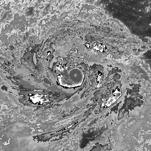
I think one of the problems with the ADT study is the assumption that the most intense tropical cyclones of the satellite era were all rated at a category 5 intensity (since every system in that study was of SSHWS category 5 intensity with the lone exception of Hellen '14). It sounds weird to say at first, but several of the basins that didn't have recon early in the satellite era had some rather intense storms that were more than likely held down by Dvorak constraints. Early geostationary satellite resolution probably didn't help either. Possibly two of the most egregious cases are from Meli (SPac, 1979) and Raymond (EPac, 1983), which are both pictured below, respectively.


With that said, it is not an easy problem to address. Honestly, the other tropical cyclone basins probably need some sort of reanalysis project like what is currently being done for the Atlantic basin implemented. We know much more about tropical cyclones now than we ever did before, so reanalysis will likely go a long way in bettering the tropical cyclone climatology, especially at the higher intensities. However, as has been seen in the ATL reanalysis, these projects can take a very long time and a large number of resources to complete.
With that said, it is not an easy problem to address. Honestly, the other tropical cyclone basins probably need some sort of reanalysis project like what is currently being done for the Atlantic basin implemented. We know much more about tropical cyclones now than we ever did before, so reanalysis will likely go a long way in bettering the tropical cyclone climatology, especially at the higher intensities. However, as has been seen in the ATL reanalysis, these projects can take a very long time and a large number of resources to complete.
2 likes
Contract Meteorologist. TAMU & MSST. Fiercely authentic, one of a kind. We are all given free will, so choose a life meant to be lived. We are the Masters of our own Stories.
Opinions expressed are mine alone.
Follow me on Twitter at @1900hurricane : Read blogs at https://1900hurricane.wordpress.com/
Opinions expressed are mine alone.
Follow me on Twitter at @1900hurricane : Read blogs at https://1900hurricane.wordpress.com/

Re: Discussion of Intense Tropical Cyclones
It simply is pathetic.
Atlantic, where the USA mainland lies, has recon.
Elsewhere, it's all problematic with ADT and satellite beauty.
Atlantic, where the USA mainland lies, has recon.
Elsewhere, it's all problematic with ADT and satellite beauty.
0 likes
Remember, all of my post aren't official. For official warnings and discussions, Please refer to your local NWS products...
NWS for the Western Pacific
https://www.weather.gov/gum/
NWS for the Western Pacific
https://www.weather.gov/gum/
-
1900hurricane
- Category 5
- Posts: 6044
- Age: 32
- Joined: Fri Feb 06, 2015 12:04 pm
- Location: Houston, TX
- Contact:
Re: Discussion of Intense Tropical Cyclones
euro6208 wrote:It simply is pathetic.
Atlantic, where the USA mainland lies, has recon.
Elsewhere, it's all problematic with ADT and satellite beauty.
Unfortunately, that's the way it is. Nothing beats in-situ measurements, but both remote sensing and our interpretation of it has come a long way since the 1970s and 1980s. Many strong correlations exist in these remote sensing methods as far as intensity estimation is concerned. Reexamining previous data should at least give us a reasonable confidence interval for intensity, which can be used to help clean up best track intensities given the opportunity. At the very least, it can create better consistency in historical intensity estimation, which is sorely lacking at the moment.
Considering my status as a Python neophyte, I'm still a ways off from doing this, but I would eventually like to write a program that will take wind velocity and other measurables to output pressure via KZC, and vice versa.
0 likes
Contract Meteorologist. TAMU & MSST. Fiercely authentic, one of a kind. We are all given free will, so choose a life meant to be lived. We are the Masters of our own Stories.
Opinions expressed are mine alone.
Follow me on Twitter at @1900hurricane : Read blogs at https://1900hurricane.wordpress.com/
Opinions expressed are mine alone.
Follow me on Twitter at @1900hurricane : Read blogs at https://1900hurricane.wordpress.com/
-
Kingarabian

- S2K Supporter

- Posts: 15432
- Joined: Sat Aug 08, 2009 3:06 am
- Location: Honolulu, Hawaii
Re: Discussion of Intense Tropical Cyclones
How big of a role do the conservative and sometimes funky analysis from the JTWC and JMA play in the discussion of intense tropical cyclones?
0 likes
RIP Kobe Bryant
-
tatertawt24
- Category 1

- Posts: 309
- Joined: Wed Oct 24, 2012 12:57 pm
Re: Discussion of Intense Tropical Cyclones
1900hurricane wrote:I think one of the problems with the ADT study is the assumption that the most intense tropical cyclones of the satellite era were all rated at a category 5 intensity (since every system in that study was of SSHWS category 5 intensity with the lone exception of Hellen '14). It sounds weird to say at first, but several of the basins that didn't have recon early in the satellite era had some rather intense storms that were more than likely held down by Dvorak constraints. Early geostationary satellite resolution probably didn't help either. Possibly two of the most egregious cases are from Meli (SPac, 1979) and Raymond (EPac, 1983), which are both pictured below, respectively.
With that said, it is not an easy problem to address. Honestly, the other tropical cyclone basins probably need some sort of reanalysis project like what is currently being done for the Atlantic basin implemented. We know much more about tropical cyclones now than we ever did before, so reanalysis will likely go a long way in bettering the tropical cyclone climatology, especially at the higher intensities. However, as has been seen in the ATL reanalysis, these projects can take a very long time and a large number of resources to complete.
Agree with Meli but Raymond doesn't look terribly impressive imo. Tiny Wilma-esque eye but kind of ugly otherwise.
0 likes
Personal Forecast Disclaimer:
The posts in this forum are NOT official forecast and should not be used as such. They are just the opinion of the poster and may or may not be backed by sound meteorological data. They are NOT endorsed by any professional institution or storm2k.org. For official information, please refer to the NHC and NWS products.
The posts in this forum are NOT official forecast and should not be used as such. They are just the opinion of the poster and may or may not be backed by sound meteorological data. They are NOT endorsed by any professional institution or storm2k.org. For official information, please refer to the NHC and NWS products.
-
NotoSans
- Category 5
- Posts: 1366
- Age: 24
- Joined: Sun Sep 27, 2015 1:15 am
- Location: Hong Kong
- Contact:
Re: Discussion of Intense Tropical Cyclones
https://ams.confex.com/ams/pdfpapers/108298.pdf
I'm not sure if this has been discussed before, but Knaff and Sampson conducted a reanalysis on WPAC tropical cyclones during the recon era using the KZC WPR. The reanalysis ranks Rita in 1978 as the most intense tropical cyclone with an intensity of 183 kt (which actually makes sense, given that Rita is a compact, fast-moving and low-latitude tropical cyclone). It also illustrates the fact that a lower central pressure does not necessarily yield a higher intensity, since some of the sub-880mb tropical cyclones in WPAC have a very large circulation or a relatively low ambient pressure (Tip in 1979 would be the best example). It is also important to note that some of the sub-890mb tropical cyclones in WPAC have a tiny RMW (for example, Forrest in 1983 and Judy in 1979), and their intensities may be overestimated by the KZC WPR. This reanalysis, however, should not be considered as the ground truth since the intensity estimates are derived from WPR, but not supported by actual measurement.
With the help of the KZC WPR, the agencies can actually conduct a pressure-based reanalysis on WPAC tropical cyclones similar to the above one. During the recon era, the JTWC derives intensity estimates from the central pressure using the AH77 WPR, which does not take into account other variables, like the size and the latitude of the tropical cyclone. The use of AH77 WPR has also led to a possible negative bias in the JTWC best track data. With the reanalysis, the consistency of the historical best track record can be improved. It may also reveal some of the bias and errors of the Dvorak technique (for example, does the Dvorak technique underestimate intensity for storms with CI6.5 or above?), which can possibly improve the accuracy of intensity estimates. However, as mentioned above, such reanalysis may take a long time to complete, especially in the WPAC, the most active basin worldwide.
1 likes
Personal Forecast Disclaimer:
The posts in this forum are NOT official forecast and should not be used as such. They are just the opinion of the poster and may or may not be backed by sound meteorological data. They are NOT endorsed by any professional institution or storm2k.org. For official information, please refer to RSMC and NWS products.
The posts in this forum are NOT official forecast and should not be used as such. They are just the opinion of the poster and may or may not be backed by sound meteorological data. They are NOT endorsed by any professional institution or storm2k.org. For official information, please refer to RSMC and NWS products.
-
tatertawt24
- Category 1
- Posts: 309
- Joined: Wed Oct 24, 2012 12:57 pm
Re: Discussion of Intense Tropical Cyclones
One that I've always wondered about was Mike of 1990. He did hit the Philippines as a cat 4 but he was falling apart when he made landfall, and as we know, the unraveling of RI'ers can be just as sudden and drastic as when they strengthen (ie Patricia). The reason I bring him up is because he had one of the best satellite presentations that I can think of when he was at his peak.

That eye can't be any more than 8 miles in diameter.
That eye can't be any more than 8 miles in diameter.
0 likes
Personal Forecast Disclaimer:
The posts in this forum are NOT official forecast and should not be used as such. They are just the opinion of the poster and may or may not be backed by sound meteorological data. They are NOT endorsed by any professional institution or storm2k.org. For official information, please refer to the NHC and NWS products.
The posts in this forum are NOT official forecast and should not be used as such. They are just the opinion of the poster and may or may not be backed by sound meteorological data. They are NOT endorsed by any professional institution or storm2k.org. For official information, please refer to the NHC and NWS products.
-
1900hurricane
- Category 5
- Posts: 6044
- Age: 32
- Joined: Fri Feb 06, 2015 12:04 pm
- Location: Houston, TX
- Contact:
Re: Discussion of Intense Tropical Cyclones
Kingarabian wrote:How big of a role do the conservative and sometimes funky analysis from the JTWC and JMA play in the discussion of intense tropical cyclones?
I'm not sure it's a huge role, but it can certainly influence the intensities assigned to a few individual storms. The two ways that I can think that can cause low Dvorak intensity estimates at the higher end is catching onto rapid intensification too slow, thus lowering model expected T numbers (MET) and bringing constraints into play too early, and also citing the incorrect eye temperature in some cases. Usually, these aren't too much of an issue, but they do sometimes come up. A good example of the former scenario happened when Super Typhoon Chaba first began to bomb out earlier this year (here and surrounding posts in the Chaba thread). With Chaba though, this probably didn't affect max intensity since the system went through eyewall replacement for a time period before reaching maximum intensity, allowing the numbers to catch up.
https://twitter.com/1900hurricane/status/782362818293092352
An example of an agency using the incorrect eye temperature also came earlier this year with Super Typhoon Nepartak, when JTWC analyzed a (very warm) warm medium grey, or WMG (>=9*C) eye as one that is off-white (OW), one BD IR color shade too cold (here and subsequent posts in the Nepartak thread). It is a little tricky sometimes to analyze small and very warm WMG eyes since there aren't very many pixels and can sometimes look OW due to the way the WMG color becomes darker with increasing temperature (see Nepartak image below). However, with ADT giving a constant readout of eye temperatures, this shouldn't be a mistake that is made. Unfortunately with Nepartak, this is a case where maximum intensity was likely affected by this mistake, since the system was only given a 150 kt intensity despite having a WMG eye embedded in cold medium grey (CMG) CDO for over 12 hours. Since Nepartak's data is still preliminary, hopefully this gets cleaned up in the the final best track data.

0 likes
Contract Meteorologist. TAMU & MSST. Fiercely authentic, one of a kind. We are all given free will, so choose a life meant to be lived. We are the Masters of our own Stories.
Opinions expressed are mine alone.
Follow me on Twitter at @1900hurricane : Read blogs at https://1900hurricane.wordpress.com/
Opinions expressed are mine alone.
Follow me on Twitter at @1900hurricane : Read blogs at https://1900hurricane.wordpress.com/
-
1900hurricane
- Category 5
- Posts: 6044
- Age: 32
- Joined: Fri Feb 06, 2015 12:04 pm
- Location: Houston, TX
- Contact:
Re: Discussion of Intense Tropical Cyclones
NotoSans wrote:https://ams.confex.com/ams/pdfpapers/108298.pdf
I'm not sure if this has been discussed before, but Knaff and Sampson conducted a reanalysis on WPAC tropical cyclones during the recon era using the KZC WPR. The reanalysis ranks Rita in 1978 as the most intense tropical cyclone with an intensity of 183 kt (which actually makes sense, given that Rita is a compact, fast-moving and low-latitude tropical cyclone). It also illustrates the fact that a lower central pressure does not necessarily yield a higher intensity, since some of the sub-880mb tropical cyclones in WPAC have a very large circulation or a relatively low ambient pressure (Tip in 1979 would be the best example). It is also important to note that some of the sub-890mb tropical cyclones in WPAC have a tiny RMW (for example, Forrest in 1983 and Judy in 1979), and their intensities may be overestimated by the KZC WPR. This reanalysis, however, should not be considered as the ground truth since the intensity estimates are derived from WPR, but not supported by actual measurement.
With the help of the KZC WPR, the agencies can actually conduct a pressure-based reanalysis on WPAC tropical cyclones similar to the above one. During the recon era, the JTWC derives intensity estimates from the central pressure using the AH77 WPR, which does not take into account other variables, like the size and the latitude of the tropical cyclone. The use of AH77 WPR has also led to a possible negative bias in the JTWC best track data. With the reanalysis, the consistency of the historical best track record can be improved. It may also reveal some of the bias and errors of the Dvorak technique (for example, does the Dvorak technique underestimate intensity for storms with CI6.5 or above?), which can possibly improve the accuracy of intensity estimates. However, as mentioned above, such reanalysis may take a long time to complete, especially in the WPAC, the most active basin worldwide.
A similar paper with the same two (and additional) authors was published in Monthly Weather Review in 2013. The base period is a little different (1945-1976), but overall methodology appears very similar.
A Pressure-Based Analysis of the Historical Western North Pacific Tropical Cyclone Intensity Record
0 likes
Contract Meteorologist. TAMU & MSST. Fiercely authentic, one of a kind. We are all given free will, so choose a life meant to be lived. We are the Masters of our own Stories.
Opinions expressed are mine alone.
Follow me on Twitter at @1900hurricane : Read blogs at https://1900hurricane.wordpress.com/
Opinions expressed are mine alone.
Follow me on Twitter at @1900hurricane : Read blogs at https://1900hurricane.wordpress.com/
-
1900hurricane
- Category 5
- Posts: 6044
- Age: 32
- Joined: Fri Feb 06, 2015 12:04 pm
- Location: Houston, TX
- Contact:
Re: Discussion of Intense Tropical Cyclones
tatertawt24 wrote:1900hurricane wrote:I think one of the problems with the ADT study is the assumption that the most intense tropical cyclones of the satellite era were all rated at a category 5 intensity (since every system in that study was of SSHWS category 5 intensity with the lone exception of Hellen '14). It sounds weird to say at first, but several of the basins that didn't have recon early in the satellite era had some rather intense storms that were more than likely held down by Dvorak constraints. Early geostationary satellite resolution probably didn't help either. Possibly two of the most egregious cases are from Meli (SPac, 1979) and Raymond (EPac, 1983), which are both pictured below, respectively.
With that said, it is not an easy problem to address. Honestly, the other tropical cyclone basins probably need some sort of reanalysis project like what is currently being done for the Atlantic basin implemented. We know much more about tropical cyclones now than we ever did before, so reanalysis will likely go a long way in bettering the tropical cyclone climatology, especially at the higher intensities. However, as has been seen in the ATL reanalysis, these projects can take a very long time and a large number of resources to complete.
Agree with Meli but Raymond doesn't look terribly impressive imo. Tiny Wilma-esque eye but kind of ugly otherwise.
I would tend to agree that Meli is more likely to be the stronger of the two, but Raymond is likely no slouch. The CMG CDO yields a starting DT of 6.5, so any eye adjustment already brings the system up to a DT of 7.0. GOES 5 image resolution leaves something to be desired, but AVHRR imagery from around the same time shows at least an OW eye, and even this pass isn't ideal since the eye is somewhat near the edge, meaning a WMG eye (and thus a DT of 7.5) is a possibility.

At the very least, it's easy to conclude that Raymond was likely more intense than its currently listed 125 kt peak intensity. In fact, Raymond was possibly the third of a trio of EPac SSHWS category 5s from 1983 that were not analyzed as so, following Barbara and Kiko.
0 likes
Contract Meteorologist. TAMU & MSST. Fiercely authentic, one of a kind. We are all given free will, so choose a life meant to be lived. We are the Masters of our own Stories.
Opinions expressed are mine alone.
Follow me on Twitter at @1900hurricane : Read blogs at https://1900hurricane.wordpress.com/
Opinions expressed are mine alone.
Follow me on Twitter at @1900hurricane : Read blogs at https://1900hurricane.wordpress.com/
-
1900hurricane
- Category 5
- Posts: 6044
- Age: 32
- Joined: Fri Feb 06, 2015 12:04 pm
- Location: Houston, TX
- Contact:
Re: Discussion of Intense Tropical Cyclones
tatertawt24 wrote:One that I've always wondered about was Mike of 1990. He did hit the Philippines as a cat 4 but he was falling apart when he made landfall, and as we know, the unraveling of RI'ers can be just as sudden and drastic as when they strengthen (ie Patricia). The reason I bring him up is because he had one of the best satellite presentations that I can think of when he was at his peak.
That eye can't be any more than 8 miles in diameter.
Mike '90 was absolutely a very intense tropical cyclone. JTWC's Annual Tropical Cyclone Report from 1990 listed Mike as a clear-cut T7.5 (despite only listing an intensity of 150 kt, which JTWC did for some reason in the years prior to 1992), and it's easy to understand why. Does anything ring a bell about a low-latitude super typhoon with a CDO featuring extensive CDG traversing the southern Philippine Sean in November?
0 likes
Contract Meteorologist. TAMU & MSST. Fiercely authentic, one of a kind. We are all given free will, so choose a life meant to be lived. We are the Masters of our own Stories.
Opinions expressed are mine alone.
Follow me on Twitter at @1900hurricane : Read blogs at https://1900hurricane.wordpress.com/
Opinions expressed are mine alone.
Follow me on Twitter at @1900hurricane : Read blogs at https://1900hurricane.wordpress.com/
-
mrbagyo

- Category 5
- Posts: 3614
- Age: 31
- Joined: Thu Apr 12, 2012 9:18 am
- Location: 14.13N 120.98E
- Contact:
Re: Discussion of Intense Tropical Cyclones
Was the 890 mb reading on STY Betty (August 1987 - recon farewell) just an estimate or recon data. Because if its recon, IMO, 140 knots is pretty low for such a compact tight storm. The reanalysis of Knaff would be pretty decent estimate(170+ knots peak).
Landfall intensity in best track is 135 I guess, that's just 5 knot reduction from peak. I think it's possible that Betty actually made landfall in N Samar as a Cat5 instead of "just" being a strong cat 4.
Betty doesnt possess the most impressive CDO but men, she is one tight system and there was also a strong ridging to its north that forced her to take a west track. Any thoughts?
0 likes
The posts in this forum are NOT official forecast and should not be used as such. They are just the opinion of the poster and may or may not be backed by sound meteorological data. They are NOT endorsed by any professional institution or storm2k.org. For official information, please refer to RSMC, NHC and NWS products.
Who is online
Users browsing this forum: duilaslol and 60 guests