Seasonal Indicators (Beyond Day 16): Instability / SST's / MSLP / Steering / Sal

This is the general tropical discussion area. Anyone can take their shot at predicting a storms path.

Moderator: S2k Moderators

Forum rules

The posts in this forum are NOT official forecasts and should not be used as such. They are just the opinion of the poster and may or may not be backed by sound meteorological data. They are NOT endorsed by any professional institution or STORM2K. For official information, please refer to products from the National Hurricane Center and National Weather Service.

Help Support Storm2K
Message
Author
User avatar
tarheelprogrammer
S2K Supporter
S2K Supporter
Posts: 1793
Joined: Mon Mar 28, 2016 9:25 pm
Location: Raleigh, NC area (Garner, NC)

Re: 2016 indicators: Instability / SST's / MSLP / Steering / Sal

#661 Postby tarheelprogrammer » Thu Jun 23, 2016 4:11 pm

RL3AO wrote:An East Coast trough will usually take something in the open Atlantic and turn it out to sea. An east coast trough will also take a Caribbean storm and turn it into the GOM.

The Caribbean has been really quiet lately. If theres a major hurricane in there, an east coast trough will not be good for the US.


Exactly my thoughts as well. It may be good for the East Coast but bad for the Gulf of Mexico residents. :eek:
0 likes   
My posts are not official forecasts. They are just my opinion and may or may not be backed by sound meteorological data. They are NOT endorsed by any professional institution or storm2k.org. For official information, please refer to the NHC and NWS products.

User avatar
srainhoutx
S2K Supporter
S2K Supporter
Posts: 6919
Age: 66
Joined: Sun Jan 14, 2007 11:34 am
Location: Haywood County, NC
Contact:

Re: 2016 indicators: Instability / SST's / MSLP / Steering / Sal

#662 Postby srainhoutx » Thu Jun 23, 2016 4:30 pm

TheStormExpert wrote:The steering pattern at the moment is very similar to that of most of 2010/2011 with an persistent East Coast trough which would recurve anything that tries to strike the U.S. from the East or Southeast. Then there is the Texas Death Ridge(which started their bad drought from a few years ago) which would shove anything that tries to sneak in from the Western Caribbean into Central America or Mexico.


There is no 'Death Ridge' anchored over Texas this year. The main Upper Ridge is well West of Texas. We have had repeated rounds of showers and thunderstorm complexes dropping SE in the NW flow aloft along the Eastern periphery of the Western Ridge. The latest Day 8+ and Day 11+ Analogs suggest the Upper Ridge will remain anchored over the Great Basin with an occasional weakness as the Eastern trough sharpens up.
0 likes   
Carla/Alicia/Jerry(In The Eye)/Michelle/Charley/Ivan/Dennis/Katrina/Rita/Wilma/Ike/Harvey

Member: National Weather Association
Wx Infinity Forums
http://wxinfinity.com/index.php

Facebook.com/WeatherInfinity
Twitter @WeatherInfinity

User avatar
tarheelprogrammer
S2K Supporter
S2K Supporter
Posts: 1793
Joined: Mon Mar 28, 2016 9:25 pm
Location: Raleigh, NC area (Garner, NC)

Re: 2016 indicators: Instability / SST's / MSLP / Steering / Sal

#663 Postby tarheelprogrammer » Fri Jun 24, 2016 4:33 pm

Nice graphic that was posted by Phil Klotzbach on twitter that corresponds with the up and coming MJO phase in the Atlantic.

https://twitter.com/philklotzbach/statu ... 1491710976
0 likes   
My posts are not official forecasts. They are just my opinion and may or may not be backed by sound meteorological data. They are NOT endorsed by any professional institution or storm2k.org. For official information, please refer to the NHC and NWS products.

RL3AO
Moderator-Pro Met
Moderator-Pro Met
Posts: 16308
Joined: Thu Jun 14, 2007 10:03 pm
Location: NC

Re: 2016 indicators: Instability / SST's / MSLP / Steering / Sal

#664 Postby RL3AO » Fri Jun 24, 2016 5:32 pm

Should be a favorable MJO in the Atlantic sometime during the first two weeks of July.
0 likes   

User avatar
TheStormExpert
Category 5
Category 5
Posts: 8487
Age: 30
Joined: Wed Feb 16, 2011 5:38 pm
Location: Palm Beach Gardens, FL

Re: 2016 indicators: Instability / SST's / MSLP / Steering / Sal

#665 Postby TheStormExpert » Fri Jun 24, 2016 5:38 pm

RL3AO wrote:Should be a favorable MJO in the Atlantic sometime during the first two weeks of July.

Wouldn't it be favorable at the same time as it is for the Eastern Pacific?
0 likes   
The following post is NOT an official forecast and should not be used as such. It is just the opinion of the poster and may or may not be backed by sound meteorological data. It is NOT endorsed by storm2k.org.

User avatar
cycloneye
Admin
Admin
Posts: 139068
Age: 67
Joined: Thu Oct 10, 2002 10:54 am
Location: San Juan, Puerto Rico

Re: 2016 indicators: Instability / SST's / MSLP / Steering / Sal

#666 Postby cycloneye » Fri Jun 24, 2016 5:40 pm

Michael Ventrice ‏@MJVentrice · 16m16 minutes ago

Seeing indications for -AO/-NAO development in July.

0 likes   
Visit the Caribbean-Central America Weather Thread where you can find at first post web cams,radars
and observations from Caribbean basin members Click Here

RL3AO
Moderator-Pro Met
Moderator-Pro Met
Posts: 16308
Joined: Thu Jun 14, 2007 10:03 pm
Location: NC

Re: 2016 indicators: Instability / SST's / MSLP / Steering / Sal

#667 Postby RL3AO » Fri Jun 24, 2016 5:42 pm

TheStormExpert wrote:
RL3AO wrote:Should be a favorable MJO in the Atlantic sometime during the first two weeks of July.

Wouldn't it be favorable at the same time as it is for the Eastern Pacific?


Generally. Obviously I'm not a waves expert, but I don't follow some on Twitter!

Image
0 likes   

User avatar
tarheelprogrammer
S2K Supporter
S2K Supporter
Posts: 1793
Joined: Mon Mar 28, 2016 9:25 pm
Location: Raleigh, NC area (Garner, NC)

Re: 2016 indicators: Instability / SST's / MSLP / Steering / Sal

#668 Postby tarheelprogrammer » Fri Jun 24, 2016 5:47 pm

cycloneye wrote:Michael Ventrice ‏@MJVentrice · 16m16 minutes ago

Seeing indications for -AO/-NAO development in July.

That would be a negative for development correct? If so good.

0 likes   
My posts are not official forecasts. They are just my opinion and may or may not be backed by sound meteorological data. They are NOT endorsed by any professional institution or storm2k.org. For official information, please refer to the NHC and NWS products.

User avatar
TheStormExpert
Category 5
Category 5
Posts: 8487
Age: 30
Joined: Wed Feb 16, 2011 5:38 pm
Location: Palm Beach Gardens, FL

Re: 2016 indicators: Instability / SST's / MSLP / Steering / Sal

#669 Postby TheStormExpert » Fri Jun 24, 2016 6:04 pm

cycloneye wrote:Michael Ventrice ‏@MJVentrice · 16m16 minutes ago

Seeing indications for -AO/-NAO development in July.


And the -NAO/-AO goes negative for the 2nd or 3rd time in the past month or two.
0 likes   
The following post is NOT an official forecast and should not be used as such. It is just the opinion of the poster and may or may not be backed by sound meteorological data. It is NOT endorsed by storm2k.org.

User avatar
BigA
Professional-Met
Professional-Met
Posts: 1317
Joined: Sun Jul 24, 2005 10:56 pm

Re: 2016 indicators: Instability / SST's / MSLP / Steering / Sal

#670 Postby BigA » Sat Jun 25, 2016 11:20 am

cycloneye wrote:Michael Ventrice ‏@MJVentrice · 16m16 minutes ago

Seeing indications for -AO/-NAO development in July.


A negative NAO (throughout the hurricane season) tends to be associated with weaker trade winds over the MDR, which is favorable for development. However, a negative NAO also tends to be associated with a weaker (and less westward- extending Bermuda high), thus making recurvature more likely.

Obviously this is only one of the many factors that affects Atlantic TCs (and if anything here is wrong, please say so).
0 likes   

User avatar
SFLcane
S2K Supporter
S2K Supporter
Posts: 9606
Age: 46
Joined: Sat Jun 05, 2010 1:44 pm
Location: Lake Worth Florida

Re: 2016 indicators: Instability / SST's / MSLP / Steering / Sal

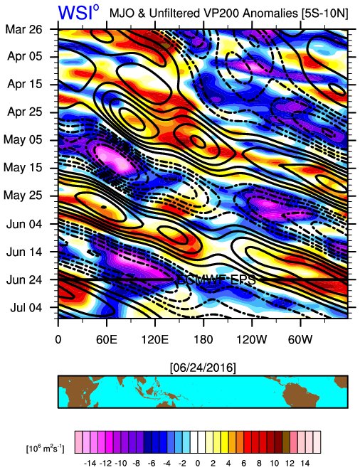
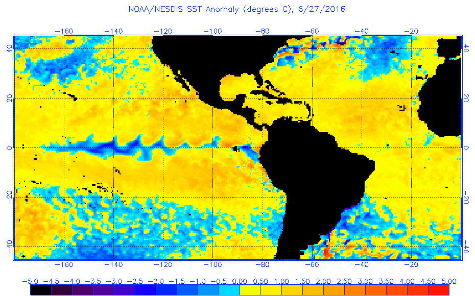
#671 Postby SFLcane » Mon Jun 27, 2016 8:29 pm

Um..... :roll:

Image

Image
0 likes   

User avatar
1900hurricane
Category 5
Category 5
Posts: 6044
Age: 32
Joined: Fri Feb 06, 2015 12:04 pm
Location: Houston, TX
Contact:

Re: 2016 indicators: Instability / SST's / MSLP / Steering / Sal

#672 Postby 1900hurricane » Mon Jun 27, 2016 9:18 pm

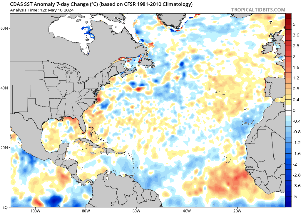
CDAS analysis via Levi Cowan still supports a negative AMO look.

Image
0 likes   
Contract Meteorologist. TAMU & MSST. Fiercely authentic, one of a kind. We are all given free will, so choose a life meant to be lived. We are the Masters of our own Stories.
Opinions expressed are mine alone.

Follow me on Twitter at @1900hurricane : Read blogs at https://1900hurricane.wordpress.com/

User avatar
TropicalAnalystwx13
Category 5
Category 5
Posts: 2109
Age: 26
Joined: Tue Jul 19, 2011 8:20 pm
Location: Wilmington, NC
Contact:

Re: 2016 indicators: Instability / SST's / MSLP / Steering / Sal

#673 Postby TropicalAnalystwx13 » Mon Jun 27, 2016 9:29 pm

1900hurricane wrote:CDAS analysis via Levi Cowan still supports a negative AMO look.

Image

When central/eastern Atlantic ocean temperatures are average while the rest of the globe is anomalously warm, yes it's going to give the appearance of a negative AMO. Actual anomalies have cooled recently under a substantial +NAO regime this past week, but they should warm again as we head more Neutral. There are signs of a -NAO for July.

The AMO has been positive all this year; May's value was the 3rd highest on record. I don't see any reason why that would change.
0 likes   

User avatar
1900hurricane
Category 5
Category 5
Posts: 6044
Age: 32
Joined: Fri Feb 06, 2015 12:04 pm
Location: Houston, TX
Contact:

Re: 2016 indicators: Instability / SST's / MSLP / Steering / Sal

#674 Postby 1900hurricane » Mon Jun 27, 2016 9:45 pm

TropicalAnalystwx13 wrote:
1900hurricane wrote:CDAS analysis via Levi Cowan still supports a negative AMO look.

Image

When central/eastern Atlantic ocean temperatures are average while the rest of the globe is anomalously warm, yes it's going to give the appearance of a negative AMO. Actual anomalies have cooled recently under a substantial +NAO regime this past week, but they should warm again as we head more Neutral. There are signs of a -NAO for July.

The AMO has been positive all this year; May's value was the 3rd highest on record. I don't see any reason why that would change.

I'll take your word on it, but I'm surprised at how something like an NAO change can have such drastic effects on the anomaly configuration. Then again, despite it being my home basin, I'm not as familiar with this basin as I am the Pacific basins, where the more interesting storms in recent years have driven my attention for personal study.
0 likes   
Contract Meteorologist. TAMU & MSST. Fiercely authentic, one of a kind. We are all given free will, so choose a life meant to be lived. We are the Masters of our own Stories.
Opinions expressed are mine alone.

Follow me on Twitter at @1900hurricane : Read blogs at https://1900hurricane.wordpress.com/

User avatar
weathaguyry
Category 5
Category 5
Posts: 1272
Age: 20
Joined: Wed Jun 15, 2016 5:16 am
Location: Long Island, NY

Re: 2016 indicators: Instability / SST's / MSLP / Steering / Sal

#675 Postby weathaguyry » Mon Jun 27, 2016 10:32 pm

Why does NOAA map state warmer than average MDR in Atlantic, and CDAS shows lots of colder water around Atlantic MDR?
0 likes   
My posts are only my opinions and NOT official forecasts. For official forecasts, consult the National Hurricane Center or the National Weather Service.

Irene 11', Sandy 12', Fay 20’, Isaias 20’, Elsa 21’, Henri 21’, Ida 21’

User avatar
Yellow Evan
Professional-Met
Professional-Met
Posts: 15951
Age: 25
Joined: Fri Jul 15, 2011 12:48 pm
Location: Henderson, Nevada/Honolulu, HI
Contact:

Re: 2016 indicators: Instability / SST's / MSLP / Steering / Sal

#676 Postby Yellow Evan » Mon Jun 27, 2016 11:17 pm

weathaguyry wrote:Why does NOAA map state warmer than average MDR in Atlantic, and CDAS shows lots of colder water around Atlantic MDR?


NOAA uses a 30 year average while CDAS is the difference between the 30 year average SSTA's and the global SSTA''s to better account for climate change.
0 likes   

User avatar
Fego
S2K Supporter
S2K Supporter
Posts: 767
Age: 64
Joined: Sun Apr 18, 2004 7:58 pm
Location: San Juan, Puerto Rico
Contact:

Re: 2016 indicators: Instability / SST's / MSLP / Steering / Sal

#677 Postby Fego » Mon Jun 27, 2016 11:42 pm

Hi all.
:uarrow: If I'm interesting in following up the SST to verify Dr Klotzbach "cold blob" theory, Which SST map :uarrow: is the best?
0 likes   
Go Giants! Go Niners! Go Warriors!

User avatar
NDG
S2K Supporter
S2K Supporter
Posts: 14933
Joined: Sun Jul 09, 2006 10:14 pm
Location: Orlando, FL

Re: 2016 indicators: Instability / SST's / MSLP / Steering / Sal

#678 Postby NDG » Tue Jun 28, 2016 6:14 am

IMO, another thing about the difference between the CDAS sst map and the NOAA map is that CDAS's are daily averages while the NOAA map are weekly averages.
That's why I dismiss the CDAS map many times, it could be bipolar in a very short period of time, lol. It also looks to do not so good closer to the poles and when the Atlantic basin is full of African dust, like in the Caribbean right now, it shows incorrectly that the SSTs are "cooler", IMO.
0 likes   

User avatar
SFLcane
S2K Supporter
S2K Supporter
Posts: 9606
Age: 46
Joined: Sat Jun 05, 2010 1:44 pm
Location: Lake Worth Florida

Re: 2016 indicators: Instability / SST's / MSLP / Steering / Sal

#679 Postby SFLcane » Tue Jun 28, 2016 9:18 am

weathaguyry wrote:Why does NOAA map state warmer than average MDR in Atlantic, and CDAS shows lots of colder water around Atlantic MDR?


Um yes it's been the story last few weeks. Depends who you talk to some say anomalies are cool others say there warm. I for one will side with NOAA.
0 likes   

tolakram
Admin
Admin
Posts: 19165
Age: 60
Joined: Sun Aug 27, 2006 8:23 pm
Location: Florence, KY (name is Mark)

Re: 2016 indicators: Instability / SST's / MSLP / Steering / Sal

#680 Postby tolakram » Tue Jun 28, 2016 9:38 am

So if the overall oceans are warming but the anomalies in the Atlantic are lower than this 'new warm normal' they will show up as cool? All we really want to know is if the temps are above the 30 year average, or really if the temps are warm enough to support a TS or Hurricane. :) I'll take the simple 30 year average approach.
0 likes   
M a r k
- - - - -
Join us in chat: Storm2K Chatroom Invite. Android and IOS apps also available.

The posts in this forum are NOT official forecasts and should not be used as such. Posts are NOT endorsed by any professional institution or STORM2K.org. For official information and forecasts, please refer to NHC and NWS products.


Return to “Talkin' Tropics”

Who is online

Users browsing this forum: duilaslol, Iceresistance, pepecool20 and 202 guests