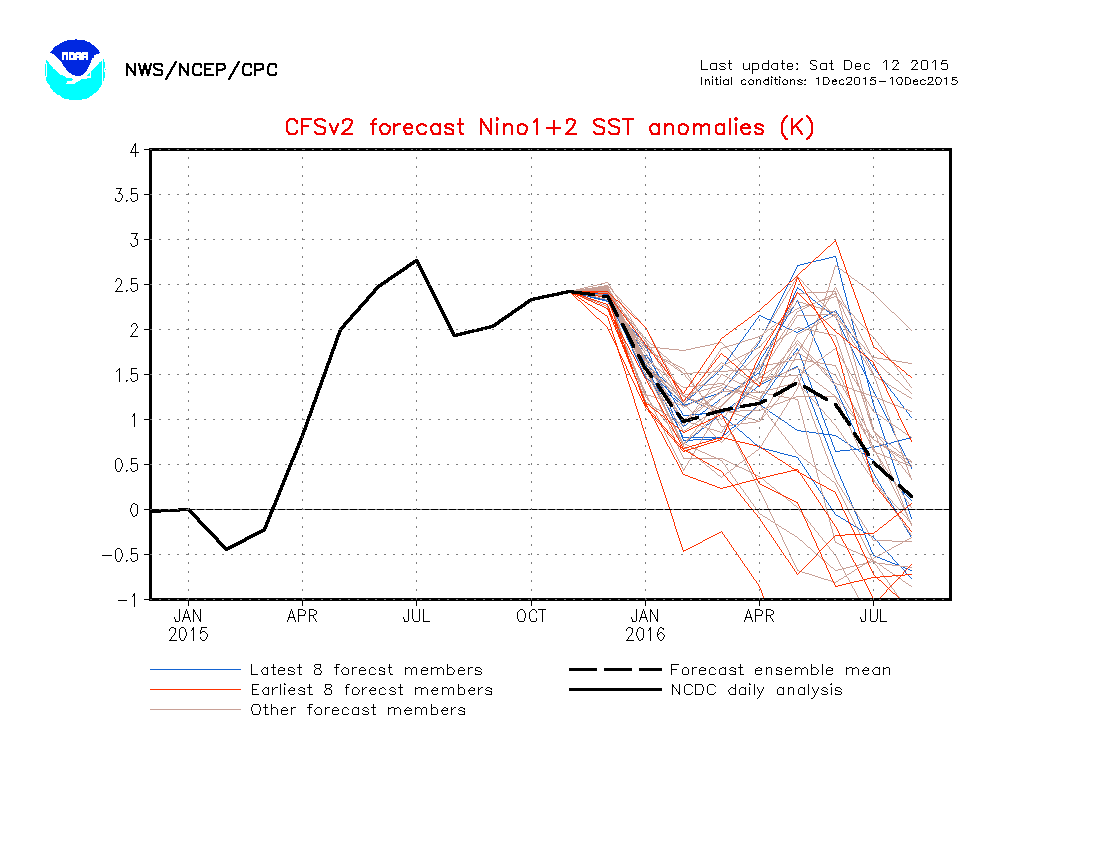
The CFS models seem to pointing towards a La Nina, but may have a warm tongue north of the ENSO which could counteract the La Nina but it also has the Atlantic rediculusly warm so that needs to be watched as El Nino erodes this spring which also IMO would be linked to lower pressures in the Atlantic so as a Forecast
as for steering if the PDO remains positive the tracks might be up the eastern seaboard and or Florida and the eastern Gulf based on typical placement of the trough ridge positions during a positive phase but if it turns negative then we have possibilities of central and western Gulf landfalls so it needs to be watched
Positives
Warm Atlantic as the CFSv2 has almost record temps for the 2016 hurricane season
El Nino switching to -Neuratl or La nina which would lessen shear over the Atlantic
I also believe the SAL will be a little less which will increase vertical instability over the Atlantic
Negatives
The warm tongue of water north of the ENSO whether it erodes or not as I expect it to not erode too much adding shear to the Atlantic side having similar effects to an El Nino and would possibly shut down the MDR and things wouldn't do much south of 20N but north of 20N could be trouble
as always this is a preliminary forecast and things could change between now and spring even so I'll give another forecast in March or early April
The posts in this forum are NOT official forecast and should not be used as such. They are just the opinion of the poster and may or may not be backed by sound meteorological data. They are NOT endorsed by any professional institution or storm2k.org. For official information, please refer to the NHC and NWS products
Seasonal Indicators (Beyond Day 16): Instability / SST's / MSLP / Steering / Sal
Moderator: S2k Moderators
Forum rules

The posts in this forum are NOT official forecasts and should not be used as such. They are just the opinion of the poster and may or may not be backed by sound meteorological data. They are NOT endorsed by any professional institution or STORM2K. For official information, please refer to products from the National Hurricane Center and National Weather Service.
-
Hurricaneman

- Category 5

- Posts: 7280
- Age: 43
- Joined: Tue Aug 31, 2004 3:24 pm
- Location: central florida
-
Andrew92

- S2K Supporter

- Posts: 3247
- Age: 40
- Joined: Mon Jun 16, 2003 12:35 am
- Location: Phoenix, Arizona
The following post is NOT an official forecast and should not be used as such. It is just the opinion of the poster and may or may not be backed by sound meteorological data. It is NOT endorsed by any professional institution or storm2k.org. For official information, please refer to the NHC and NWS products.
This early prediction absolutely reeks of 1959, or another year Alyono mentioned in another thread, 1992. Both years were La Nina but with a tongue of warm anomalies further north, between 10-20 degrees latitude, and a fair distance off Central America, with some weak anomalies closer to the coast.
Both 1959 and 1992 saw the MDR almost completely shut down. They both saw multiple storms form from non-tropical origins. They were both the first year after an El Nino year. Heck, both even had a hurricane hit Hawaii of all things. The biggest difference is 1959 was during an active Atlantic phase, whereas 1992 was during an inactive phase.
That difference, in my opinion, is crucial. Only Andrew formed from a tropical wave in 1992, but several systems managed to form from tropical waves in 1959, provided they got north of 20 degrees for the most part.
I guess I need to study up more on the PDO in general to learn if such a warm tongue is enough to constitute a positive event of if more is needed. The one big elephant in the room anyway is that the Gulf has not had a hurricane for two consecutive years. This is an extremely rare event and the last time it has officially happened, the last time it probably happened, and the last time it was very close to happening, all were followed by a major hurricane there the next year. 2016 will fit that bill perfectly, so I firmly believe the Gulf needs to be watched.
On top of that, the first year after any El Nino (traditional or Modoki) itself strongly favors hurricanes in the Gulf. In the past 17 seasons that came off an El Nino of any kind, only one season (1978) did not produce any hurricanes in the Gulf. Additionally, you can add 1954, 1959 (!), 1973, 2003, and 2007 as years without a major the first year after an El Nino.
While a strong PDO may favor East Coast, Florida, or eastern Gulf hits, most first-years-after trend toward the western Gulf, though all areas need to watch out. 16 major hurricanes in the aforementioned 17 seasons either made it into or formed in the Gulf, and only four hit east of the Mississippi. I should like to point out to those who don't know, I do not merely call any storm with at least 111 mph winds a major, as the Saffir/Simpson scale gives a recommended pressure of below 965 mb as the starting point for Category 3. Therefore, any hurricane with a pressure that low has my respect as if it is a major.
One thing I didn't address last night was East Coast hits. In these 17 seasons, there have been twelve hurricanes hit the East Coast, six of them majors by wind and/or pressure. It should be noted, however, that three of these storms were in 1954, all of them having the recommended pressure of a major at landfall that year.
Still, only 1973 and 1978 failed to produce even a tropical storm brush on the East Coast in a year following an El Nino. So that area should absolutely watch out. Perhaps this could only further solidify 1959 as the analog year to beat, in my opinion....if I wasn't so sure a major won't reach the Gulf like I fear. And that year still had five storms in the Gulf, two of which were hurricanes, so it isn't like it was exactly full-on quiet there that year either.
Given that 2015 still saw 11 named storms with four hurricanes in the Atlantic, my guess is the active period is still going on in the Atlantic, yet another point for 1959. But I do still like 1992 as an analog as well, as I sense a lot of non-tropical forming storms next year as well if the MDR is shut down, but can't ignore the inactive Gulf in recent years and what usually follows.
-Andrew92
0 likes

One thing we have to remember is that the atmosphere does not have a memory. We can only go back to historical odds but really it does what the conditions are present at the time.
With that aside, I can guess that we won't be in a quick La Nina in 2016 at least by what the CFSv2 is forecasting. As far as the end of the run it gets us back to neutral by mid summer 2016. It is still showing an "El Nino" look albeit much weaker May of 2016. It's subsurface depiction does not yet show a La Nina. This so far is speculation based on historical El Nino's favoring the switch, but there is no guarantee it will yet.
Hard flip years to Nina's such as 1973, 1998, and 2010 were already occurring by middle to late spring. So if it is going to flip quickly we would know very soon.
The Atlantic looks warm, that warmth in the western/NW Atlantic that has been around for several year remains.
0 likes
The above post and any post by Ntxw is NOT an official forecast and should not be used as such. It is just the opinion of the poster and may or may not be backed by sound meteorological data. It is NOT endorsed by any professional institution including Storm2k. For official information, please refer to NWS products.
Help support Storm2K!
-
ninel conde
- Category 5
- Posts: 1245
- Joined: Mon Aug 04, 2008 2:18 pm
if we finally have an above normal severe weather season the atlantic should be hyper active.
0 likes
The posts in this forum are NOT official forecast and should not be used as such. They are just the opinion of the poster and may or may not be backed by sound meteorological data. They are NOT endorsed by any professional institution or storm2k.org. For official information, please refer to the NHC and NWS products.
Re:
ninel conde wrote:if we finally have an above normal severe weather season the atlantic should be hyper active.
wait for 2017 until we see hyperactivity in the Atlantic
Next year should be well below average, but we could see an intense storm striking the USA
0 likes

Re: 2016 indicators: Instability / SST's / MSLP / Steering / Sal
0 likes
-
Andrew92
- S2K Supporter
- Posts: 3247
- Age: 40
- Joined: Mon Jun 16, 2003 12:35 am
- Location: Phoenix, Arizona
Re: Re:
Alyono wrote:ninel conde wrote:if we finally have an above normal severe weather season the atlantic should be hyper active.
wait for 2017 until we see hyperactivity in the Atlantic
Next year should be well below average, but we could see an intense storm striking the USA
2017 also may have an even better chance of a major hurricane reaching the US. The second year after a traditional El Nino has always been bad news for someone. The first year after can be hit-or-miss.
Still, I would be fairly surprised if there isn't one intense storm hitting the US in 2016, probably a homegrown development. But as Ntxw said, the atmosphere will go with what is current, and a lot can and likely will happen between now and then.
-Andrew92
0 likes
-
CrazyC83
- Professional-Met

- Posts: 33393
- Joined: Tue Mar 07, 2006 11:57 pm
- Location: Deep South, for the first time!
Years coming out of a strong El Nino have had a mixed bag:
1958: 11/6/5 (reanalyzed)
1966: 11/7/3
1973: 8/4/1
1983: 4/3/1
1998: 14/10/3
1983 seems the outlier as the least active year in the Recon era, but generally it appears those seasons have near to slightly above normal activity. It is reasonable to believe that 1966 will be increased to about 13 or 14 storms in reanalysis, and 1973 to between 10 and 12 storms.
Based on that, I think an early guess could be 14 named storms, with 6 hurricanes and 3 major hurricanes. Somewhere right around average.
0 likes
Re:
CrazyC83 wrote:Years coming out of a strong El Nino have had a mixed bag:
1958: 11/6/5 (reanalyzed)
1966: 11/7/3
1973: 8/4/1
1983: 4/3/1
1998: 14/10/3
1983 seems the outlier as the least active year in the Recon era, but generally it appears those seasons have near to slightly above normal activity. It is reasonable to believe that 1966 will be increased to about 13 or 14 storms in reanalysis, and 1973 to between 10 and 12 storms.
Based on that, I think an early guess could be 14 named storms, with 6 hurricanes and 3 major hurricanes. Somewhere right around average.
you need to look at ALL of the SST data, not just the equatorial data
0 likes
-
TimeZone
Re: Re:
Alyono wrote:ninel conde wrote:if we finally have an above normal severe weather season the atlantic should be hyper active.
wait for 2017 until we see hyperactivity in the Atlantic
Next year should be well below average, but we could see an intense storm striking the USA
Yikes. Again? The Tropics in the Atlantic have been extremely boring the past while now.
Sucks losing interest.
0 likes
-
Hurricaneman
- Category 5
- Posts: 7280
- Age: 43
- Joined: Tue Aug 31, 2004 3:24 pm
- Location: central florida
Re:
Alyono wrote:EC is preliminarily showing well above average pressures east of the Caribbean. However, showing average Caribbean pressures and below average in Bahamas and Gulf
Based on that a lesser version of the 2005 season might be in the cards in as I mean storm tracks with half the activity as right now I'm guessing a season with 14\8\4 for 2016 with changes as we get closer
The posts in this forum are NOT official forecast and should not be used as such. They are just the opinion of the poster and may or may not be backed by sound meteorological data. They are NOT endorsed by any professional institution or storm2k.org. For official information, please refer to the NHC and NWS products
0 likes
-
Andrew92
- S2K Supporter
- Posts: 3247
- Age: 40
- Joined: Mon Jun 16, 2003 12:35 am
- Location: Phoenix, Arizona
Re: 2016 indicators: Instability / SST's / MSLP / Steering / Sal
Thought I would bring this link shared by Ninel Conde on the 2015 thread. This is the NCEP's prediction for July 2016 SST anomalies:
https://pbs.twimg.com/media/CRRu7MnUcAAwtt-.png
I just took another look at the SST anomalies in July 1959 and July 1983 again, and compared it to that image. My findings do corroborate Alyono's initial thoughts of being similar to 1983, in that there is a warm pool from about 120 degrees going east and then north to Central America, fizzling for the most part a bit south of Mexico. But warm anomalies didn't go any further west that year, though there was no cold tongue on the Equator either.
Contrast that to 1959. La Nina was quite healthy at the Equator, but some decent warm anomalies were present off of Central America and Mexico, with a solid warm pool centered in the heart of the EPAC MDR and extending to about 130 degrees. Basically, if this forecast is right, it looks like some kind of mix between those two years.
I can post the images I have for July of those two years if anyone is interested. If I do, just a heads up that they are filtered between 80 degrees west and the International Date Line, and the Equator and 20 degrees north.
-Andrew92
0 likes
Re: 2016 indicators: Instability / SST's / MSLP / Steering / Sal
IMO is too early to say what the conditions will be at ENSO and the Atlantic Basin for sure but one thing for sure is that lately CFSv2 has been persistent is below average windshear across the Caribbean and now it shows Nino 1+2 to also cool down along with Nino 3.4, unlike summer of '83, but like I said is too early to write on stone.
0 likes
Again, lets not focus on ENSO alone, or at least the academic definitions of it being points along the equator.
Focus on the waters just north of the equator. Those waters are independent of ENSO, which are predicted to remain very warm.
Now, if pressures are below average in the Gulf, I could see a below average season, but with 3 or 4 storms in the Gulf, along with a couple of hurricanes. not sure we would consider that kind of season to be quiet as it would likely produce an above average number of landfalls
0 likes
Re:
Andrew92 wrote:It now shows the warm tongue, or does not show it? Little confused.
-Andrew92
does not show it. Shows a bit of a lingering, but decaying niño with near normal temps in the EPAC MDR. A bit more favorable than before
0 likes