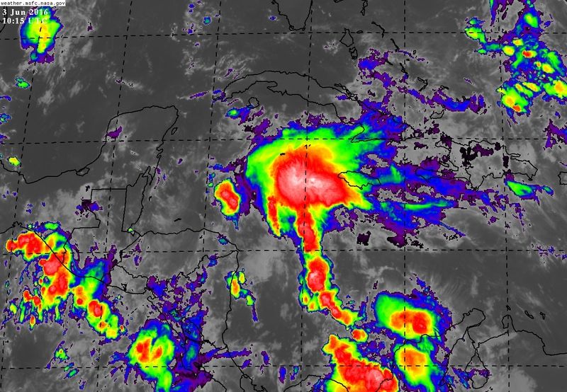
Area of disturbed weather in NW Caribbean (Is Invest 93L)

This is the general tropical discussion area. Anyone can take their shot at predicting a storms path.

Moderator: S2k Moderators

Forum rules

The posts in this forum are NOT official forecasts and should not be used as such. They are just the opinion of the poster and may or may not be backed by sound meteorological data. They are NOT endorsed by any professional institution or STORM2K. For official information, please refer to products from the National Hurricane Center and National Weather Service.

Help Support Storm2K
Message
Author
User avatar
AdamFirst
S2K Supporter
S2K Supporter
Posts: 2487
Age: 35
Joined: Thu Aug 14, 2008 10:54 am
Location: Port Saint Lucie, FL

Re: Tropical development in Southern Gulf of Mexico?

#181 Postby AdamFirst » Fri Jun 03, 2016 12:43 am

The 00z GFS loses this completely after it enters Florida, whereas previous model runs still had defined, albeit weak, systems emerging quickly into the Atlantic.

A sheared storm, with most of the energy displaced to the east, should probably be the safe bet here. A run at intensification, if any, would probably occur during its time over the Gulf Stream, after it vacates Florida.

The posts in this forum are NOT official forecast and should not be used as such. They are just the opinion of the poster and may or may not be backed by sound meteorological data. They are NOT endorsed by any professional institution or storm2k.org. For official information, please refer to the NHC and NWS products.


EURO run beginning shortly.
0 likes   
Dolphins Marlins Canes Golden Panthers HEAT
Andrew 1992 - Irene 1999 - Frances 2004 - Jeanne 2004 - Wilma 2005 - Fay 2008 - Isaac 2012 - Matthew 2016 - Irma 2017 - Dorian 2019 - Ian 2022 - Nicole 2022

User avatar
Kingarabian
S2K Supporter
S2K Supporter
Posts: 15434
Joined: Sat Aug 08, 2009 3:06 am
Location: Honolulu, Hawaii

Re: Tropical development in Southern Gulf of Mexico?

#182 Postby Kingarabian » Fri Jun 03, 2016 12:48 am

Interesting to see what the Euro shows.
0 likes   
RIP Kobe Bryant

User avatar
TheStormExpert
Category 5
Category 5
Posts: 8487
Age: 30
Joined: Wed Feb 16, 2011 5:38 pm
Location: Palm Beach Gardens, FL

Re: Tropical development in Southern Gulf of Mexico?

#183 Postby TheStormExpert » Fri Jun 03, 2016 1:07 am

TROPICAL WEATHER OUTLOOK
NWS NATIONAL HURRICANE CENTER MIAMI FL
200 AM EDT FRI JUN 3 2016

A broad low pressure area is expected to form over the Yucatan Peninsula of Mexico or the southern Gulf of Mexico by late this weekend. Although upper-level winds are not forecast to be particularly conducive for tropical cyclone formation, additional development of the low could occur when it moves generally northeastward across the central and eastern Gulf of Mexico early next week. This system is likely to produce heavy rains and possible flooding over portions of the Yucatan Peninsula, western Cuba and the Florida peninsula.

* Formation chance through 48 hours...low...near 0 percent
* Formation chance through 5 days...medium...50 percent
Last edited by TheStormExpert on Fri Jun 03, 2016 1:17 am, edited 1 time in total.
0 likes   
The following post is NOT an official forecast and should not be used as such. It is just the opinion of the poster and may or may not be backed by sound meteorological data. It is NOT endorsed by storm2k.org.

User avatar
Kingarabian
S2K Supporter
S2K Supporter
Posts: 15434
Joined: Sat Aug 08, 2009 3:06 am
Location: Honolulu, Hawaii

Re: Tropical development in Southern Gulf of Mexico?

#184 Postby Kingarabian » Fri Jun 03, 2016 1:12 am

Euro coming out a little stronger this run.
0 likes   
RIP Kobe Bryant

User avatar
TheStormExpert
Category 5
Category 5
Posts: 8487
Age: 30
Joined: Wed Feb 16, 2011 5:38 pm
Location: Palm Beach Gardens, FL

Re: Tropical development in Southern Gulf of Mexico?

#185 Postby TheStormExpert » Fri Jun 03, 2016 1:16 am

More organized @ Hr.96.

Image
0 likes   
The following post is NOT an official forecast and should not be used as such. It is just the opinion of the poster and may or may not be backed by sound meteorological data. It is NOT endorsed by storm2k.org.

User avatar
Hammy
Category 5
Category 5
Posts: 5594
Age: 40
Joined: Fri May 25, 2012 5:25 pm
Contact:

Re: Tropical development in Southern Gulf of Mexico?

#186 Postby Hammy » Fri Jun 03, 2016 1:24 am

Kingarabian wrote:Euro coming out a little stronger this run.


What's particularly interesting with this as well is that the Euro has been essentially following the GEM, with the latter trending first.
0 likes   
The above post is not official and should not be used as such. It is the opinion of the poster and may or may not be backed by sound meteorological data. It is not endorsed by any professional institution or storm2k.org. For official information, please refer to the NHC and NWS products.

User avatar
tailgater
S2K Supporter
S2K Supporter
Posts: 3339
Joined: Sun Jul 11, 2004 9:13 pm
Location: St. Amant La.

Re: Area of disturbed weather in the northwest Caribbean Sea

#187 Postby tailgater » Fri Jun 03, 2016 3:29 am

Well this system will not be be a naked swirl in it's early stages
Image

http://www.ssd.noaa.gov/goes/east/carb/flash-avn.html
0 likes   
The following post is NOT an official forecast and should not be used as such. It is just the opinion of the poster and may or may not be backed by sound meteorological data. It is NOT endorsed by any professional institution including storm2k.org For Official Information please refer to the NHC and NWS products.

User avatar
cycloneye
Admin
Admin
Posts: 139080
Age: 67
Joined: Thu Oct 10, 2002 10:54 am
Location: San Juan, Puerto Rico

Re: Area of disturbed weather in the northwest Caribbean Sea

#188 Postby cycloneye » Fri Jun 03, 2016 5:06 am

Loop of disturbed area in NW Caribbean from Ramdis floater.

http://rammb.cira.colostate.edu/ramsdis ... display=12
0 likes   
Visit the Caribbean-Central America Weather Thread where you can find at first post web cams,radars
and observations from Caribbean basin members Click Here

User avatar
SFLcane
S2K Supporter
S2K Supporter
Posts: 9606
Age: 46
Joined: Sat Jun 05, 2010 1:44 pm
Location: Lake Worth Florida

Re: Area of disturbed weather in the northwest Caribbean Sea

#189 Postby SFLcane » Fri Jun 03, 2016 5:39 am

06z GFS has shredded mess into central Florida. Rainfall will be headline here as is with most June systems.
0 likes   

User avatar
drezee
S2K Supporter
S2K Supporter
Posts: 3643
Joined: Mon Jun 09, 2003 12:49 pm
Location: FL

Re: Area of disturbed weather in the northwest Caribbean Sea

#190 Postby drezee » Fri Jun 03, 2016 5:43 am

cycloneye wrote:Loop of disturbed area in NW Caribbean from Ramdis floater.

http://rammb.cira.colostate.edu/ramsdis ... display=12

Yes, Shortwave IR clearly shows wind curvature around Nic/Honduras border. Pressures below 1010...interesting
0 likes   

User avatar
northjaxpro
S2K Supporter
S2K Supporter
Posts: 8900
Joined: Mon Sep 27, 2010 11:21 am
Location: Jacksonville, FL

Re: Area of disturbed weather in NW Caribbean

#191 Postby northjaxpro » Fri Jun 03, 2016 5:52 am

:uarrow: Looking at the satellite loop to my untrained eye, it possibly appears that may be where our developing Low Pressure area may be originating right now. There is a very pronounced spin off the Nicaragua coast from the mid-levels which may be trying to obtain a low level surface reflection.
.
0 likes   
NEVER, EVER SAY NEVER in the tropics and weather in general, and most importantly, with life itself!!

________________________________________________________________________________________

Fay 2008 Beryl 2012 Debby 2012 Colin 2016 Hermine 2016 Julia 2016 Matthew 2016 Irma 2017 Dorian 2019

jlauderdal
S2K Supporter
S2K Supporter
Posts: 6771
Joined: Wed May 19, 2004 5:46 am
Location: NE Fort Lauderdale
Contact:

Re: Area of disturbed weather in the northwest Caribbean Sea

#192 Postby jlauderdal » Fri Jun 03, 2016 5:53 am

SFLcane wrote:06z GFS has shredded mess into central Florida. Rainfall will be headline here as is with most June systems.


if the front stalls as predicted next week someone has a chance of some really big rains after the low departs
0 likes   

User avatar
NDG
S2K Supporter
S2K Supporter
Posts: 14933
Joined: Sun Jul 09, 2006 10:14 pm
Location: Orlando, FL

Re: Area of disturbed weather in NW Caribbean

#193 Postby NDG » Fri Jun 03, 2016 5:55 am

I think that as soon we start seeing a low level vorticity developing in the NW Caribbean/GOH area an invest will be up.

Image
0 likes   

User avatar
NDG
S2K Supporter
S2K Supporter
Posts: 14933
Joined: Sun Jul 09, 2006 10:14 pm
Location: Orlando, FL

Re: Area of disturbed weather in NW Caribbean

#194 Postby NDG » Fri Jun 03, 2016 6:36 am

TROPICAL WEATHER DISCUSSION
NWS NATIONAL HURRICANE CENTER MIAMI FL
805 AM EDT FRI JUN 3 2016


CARIBBEAN SEA...
The main feature in the basin is a tropical wave
moving across the SW waters discussed in more details in the
tropical waves section. An upper trough over the SW N Atlantic
with base near the Windward passage and a broad ridge anchored N
of Colombia promote a diffluent and unstable environment across
the SW, central and portions of NW Caribbean. Given the favorable
lifting dynamics and the presence of the tropical wave, numerous heavy
showers and tstms are occurring from 15N-20N between 76W and 83W
Scattered moderate to isolated strong convection is S of 15N
between 73W and 80W. Scattered to isolated showers are occurring
elsewhere E of 73W. Strong high pres NE of the Caribbean tightens
the gradient and support moderate to fresh trades over the
eastern basin and fresh to strong S of 18N E of the tropical wave
axis to 66W. The area of fresh to strong trades are expected to
expand and drift W-NW as the tropical wave continues its westward
path and a low pres forms over the weekend N of Honduras. Strong
to near gale force SE winds will accompany this low pressure area
on its eastern periphery and impact the NW Caribbean waters and
Yucatan Channel region
.
0 likes   

User avatar
cycloneye
Admin
Admin
Posts: 139080
Age: 67
Joined: Thu Oct 10, 2002 10:54 am
Location: San Juan, Puerto Rico

Re: Area of disturbed weather in NW Caribbean

#195 Postby cycloneye » Fri Jun 03, 2016 6:56 am

Up to 10%/60%

TROPICAL WEATHER OUTLOOK
NWS NATIONAL HURRICANE CENTER MIAMI FL
800 AM EDT FRI JUN 3 2016

For the North Atlantic...Caribbean Sea and the Gulf of Mexico:

The National Hurricane Center is issuing advisories on Tropical
Depression Bonnie, located about 130 miles east-northeast of Cape
Hatteras, North Carolina.

An area of showers and thunderstorms has developed over the western
Caribbean Sea. This system is moving west-northwestward toward the
Yucatan Peninsula of Mexico, and a low pressure area is expected to
form over the Yucatan or the adjacent waters by late this weekend.
This low could develop into a tropical cyclone as it subsequently
moves across the eastern Gulf of Mexico and the Florida Peninsula
early next week. Regardless of development, locally heavy rains and
flooding are possible over portions of the Yucatan Peninsula,
western Cuba and the Florida Peninsula during the next several days.
* Formation chance through 48 hours...low...10 percent
* Formation chance through 5 days...medium...60 percent

$$
Forecaster Beven
0 likes   
Visit the Caribbean-Central America Weather Thread where you can find at first post web cams,radars
and observations from Caribbean basin members Click Here

User avatar
TheStormExpert
Category 5
Category 5
Posts: 8487
Age: 30
Joined: Wed Feb 16, 2011 5:38 pm
Location: Palm Beach Gardens, FL

Re: Area of disturbed weather in NW Caribbean

#196 Postby TheStormExpert » Fri Jun 03, 2016 7:06 am

Image

Image
0 likes   
The following post is NOT an official forecast and should not be used as such. It is just the opinion of the poster and may or may not be backed by sound meteorological data. It is NOT endorsed by storm2k.org.

tolakram
Admin
Admin
Posts: 19165
Age: 60
Joined: Sun Aug 27, 2006 8:23 pm
Location: Florence, KY (name is Mark)

Re: Area of disturbed weather in NW Caribbean

#197 Postby tolakram » Fri Jun 03, 2016 7:11 am

0 likes   
M a r k
- - - - -
Join us in chat: Storm2K Chatroom Invite. Android and IOS apps also available.

The posts in this forum are NOT official forecasts and should not be used as such. Posts are NOT endorsed by any professional institution or STORM2K.org. For official information and forecasts, please refer to NHC and NWS products.

User avatar
gatorcane
S2K Supporter
S2K Supporter
Posts: 23499
Age: 46
Joined: Sun Mar 13, 2005 3:54 pm
Location: Boca Raton, FL

Re: Area of disturbed weather in NW Caribbean

#198 Postby gatorcane » Fri Jun 03, 2016 7:16 am

NDG wrote:I think that as soon we start seeing a low level vorticity developing in the NW Caribbean/GOH area an invest will be up.

http://i20.photobucket.com/albums/b245/ ... 5pqm0s.jpg


Agreed. Spin is clearly evident. Maybe even an invest later today.
0 likes   

User avatar
cycloneye
Admin
Admin
Posts: 139080
Age: 67
Joined: Thu Oct 10, 2002 10:54 am
Location: San Juan, Puerto Rico

Re: Area of disturbed weather in NW Caribbean

#199 Postby cycloneye » Fri Jun 03, 2016 7:25 am

My personal odds of having Invest 93L sometime on Friday are up to 80%.
0 likes   
Visit the Caribbean-Central America Weather Thread where you can find at first post web cams,radars
and observations from Caribbean basin members Click Here

User avatar
cycloneye
Admin
Admin
Posts: 139080
Age: 67
Joined: Thu Oct 10, 2002 10:54 am
Location: San Juan, Puerto Rico

Re: Area of disturbed weather in NW Caribbean

#200 Postby cycloneye » Fri Jun 03, 2016 9:07 am

Great video by Levi Cowen about the disturbance.

http://www.tropicaltidbits.com/blog/201 ... next-week/
0 likes   
Visit the Caribbean-Central America Weather Thread where you can find at first post web cams,radars
and observations from Caribbean basin members Click Here


Return to “Talkin' Tropics”

Who is online

Users browsing this forum: Google [Bot], NotSparta, Zonacane and 207 guests