NW Caribbean Convection
Moderator: S2k Moderators
Forum rules

The posts in this forum are NOT official forecasts and should not be used as such. They are just the opinion of the poster and may or may not be backed by sound meteorological data. They are NOT endorsed by any professional institution or STORM2K. For official information, please refer to products from the National Hurricane Center and National Weather Service.
-
northjaxpro

- S2K Supporter

- Posts: 8900
- Joined: Mon Sep 27, 2010 11:21 am
- Location: Jacksonville, FL
Re: NW Caribbean Convection
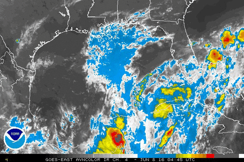
Yeah, I was leaning mid-level as well. However, if convection can flare-up over that area today, it would not take much for this system to work down to the surface. It is something to watch for sure.
0 likes
NEVER, EVER SAY NEVER in the tropics and weather in general, and most importantly, with life itself!!
________________________________________________________________________________________
Fay 2008 Beryl 2012 Debby 2012 Colin 2016 Hermine 2016 Julia 2016 Matthew 2016 Irma 2017 Dorian 2019
________________________________________________________________________________________
Fay 2008 Beryl 2012 Debby 2012 Colin 2016 Hermine 2016 Julia 2016 Matthew 2016 Irma 2017 Dorian 2019
-
TheStormExpert

- Category 5

- Posts: 8487
- Age: 30
- Joined: Wed Feb 16, 2011 5:38 pm
- Location: Palm Beach Gardens, FL
Re: NW Caribbean Convection
Wind shear seems to be low and decreasing, and there is a anti-cyclone over the western tip of Cuba.


0 likes
The following post is NOT an official forecast and should not be used as such. It is just the opinion of the poster and may or may not be backed by sound meteorological data. It is NOT endorsed by storm2k.org.
-
TheStormExpert
- Category 5
- Posts: 8487
- Age: 30
- Joined: Wed Feb 16, 2011 5:38 pm
- Location: Palm Beach Gardens, FL
Re: NW Caribbean Convection
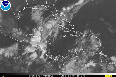
Shows up nicely on the visible satellite loop, but convection is minimal at best at the moment.

0 likes
The following post is NOT an official forecast and should not be used as such. It is just the opinion of the poster and may or may not be backed by sound meteorological data. It is NOT endorsed by storm2k.org.
-
northjaxpro
- S2K Supporter
- Posts: 8900
- Joined: Mon Sep 27, 2010 11:21 am
- Location: Jacksonville, FL
Re: NW Caribbean Convection
Observing Key West radar, starting to see possibly some convection beginning to flare within the circulation. If we see a substantial increase with convection today, we will see this work down to the surface. Definirely a mid-level circulation for now.
0 likes
NEVER, EVER SAY NEVER in the tropics and weather in general, and most importantly, with life itself!!
________________________________________________________________________________________
Fay 2008 Beryl 2012 Debby 2012 Colin 2016 Hermine 2016 Julia 2016 Matthew 2016 Irma 2017 Dorian 2019
________________________________________________________________________________________
Fay 2008 Beryl 2012 Debby 2012 Colin 2016 Hermine 2016 Julia 2016 Matthew 2016 Irma 2017 Dorian 2019
-
jlauderdal
- S2K Supporter
- Posts: 6771
- Joined: Wed May 19, 2004 5:46 am
- Location: NE Fort Lauderdale
- Contact:
Re: NW Caribbean Convection
northjaxpro wrote:Observing Key West radar, starting to see possibly some convection beginning to flare within the circulation. If we see a substantial increase with convection today, we will see this work down to the surface. Definirely a mid-level circulation for now.

0 likes
-
tropicwatch

- Category 5
- Posts: 3205
- Age: 60
- Joined: Sat Jun 02, 2007 10:01 am
- Location: Panama City Florida
- Contact:
Re: NW Caribbean Convection
Close to live visible zoomed loop of area.
http://weather.msfc.nasa.gov/cgi-bin/get-goes?satellite=GOES-E%20CONUS&lat=22&lon=-86.5&type=Animation&info=vis&numframes=15
http://weather.msfc.nasa.gov/cgi-bin/get-goes?satellite=GOES-E%20CONUS&lat=22&lon=-86.5&type=Animation&info=vis&numframes=15
0 likes
Tropicwatch
Agnes 72', Eloise 75, Elena 85', Kate 85', Charley 86', Florence 88', Beryl 94', Dean 95', Erin 95', Opal 95', Earl 98', Georges 98', Ivan 2004', Arlene 2005', Dennis 2005', Ida 2009' Debby 2012' Irma 2017' Michael 2018'
Agnes 72', Eloise 75, Elena 85', Kate 85', Charley 86', Florence 88', Beryl 94', Dean 95', Erin 95', Opal 95', Earl 98', Georges 98', Ivan 2004', Arlene 2005', Dennis 2005', Ida 2009' Debby 2012' Irma 2017' Michael 2018'
-
TheAustinMan

- Category 4

- Posts: 997
- Age: 24
- Joined: Mon Jul 08, 2013 4:26 pm
- Location: United States
- Contact:
Re: NW Caribbean Convection
Code: Select all
ZCZC MIATWOAT ALL
TTAA00 KNHC DDHHMM

TROPICAL WEATHER OUTLOOK
NWS NATIONAL HURRICANE CENTER MIAMI FL
200 PM EDT WED JUN 8 2016

For the North Atlantic...Caribbean Sea and the Gulf of Mexico:

1. Disturbed weather extending from near western Cuba to the southern
Florida Peninsula is associated with a weak trough.  This system is
expected to move northeastward and eastward over the next couple of
days, and significant development is not anticipated.  Regardless of
development, locally heavy rains are likely over portions of
western Cuba, the Florida Keys, the Florida Peninsula, and the
western Bahamas through Thursday.
* Formation chance through 48 hours...low...10 percent
* Formation chance through 5 days...low...10 percent

Forecaster Pasch


0 likes


Treat my opinions with a grain of salt. For official information see your local weather service.
-
wxman57

- Moderator-Pro Met

- Posts: 22482
- Age: 66
- Joined: Sat Jun 21, 2003 8:06 pm
- Location: Houston, TX (southwest)
Re: NW Caribbean Convection
10% is the lowest probability the NHC identifies. Development chances may be lower than 10% but I don't think they're zero with this wave. Lots of shear to contend with in the western Caribbean & eastern Gulf, as we saw with Colin.
0 likes
-
HurricaneEric
- Tropical Storm

- Posts: 146
- Age: 29
- Joined: Mon Sep 07, 2015 11:06 am
- Location: Miami, FL
Re: NW Caribbean Convection
wxman57 wrote:10% is the lowest probability the NHC identifies. Development chances may be lower than 10% but I don't think they're zero with this wave. Lots of shear to contend with in the western Caribbean & eastern Gulf, as we saw with Colin.
Not much sheer around the system at the moment and the sheer is forecast to drop there. Only reason I see it being such a low development chance is its not going to get a chance to develop soon as it tracks over South Fla.
0 likes
Irene '99, Katrina '05, Wilma '05, Irma '17 (storms I remember my area getting hurricane force winds/gusts).
The posts in this forum are NOT official forecast and shouldn't be used as such. They are just the opinion of the poster and may or may not be backed by sound meteorological data. For official information, please refer to the experts.
The posts in this forum are NOT official forecast and shouldn't be used as such. They are just the opinion of the poster and may or may not be backed by sound meteorological data. For official information, please refer to the experts.

Re: NW Caribbean Convection

EC has that LP Meandering about the vorticity is evident on wind realtime earthmaps, if it can get some moisture flowing in may cause some weather for Florida down the road.
Last edited by stormwise on Wed Jun 08, 2016 8:49 pm, edited 1 time in total.
0 likes
-
cycloneye

- Admin

- Posts: 139077
- Age: 67
- Joined: Thu Oct 10, 2002 10:54 am
- Location: San Juan, Puerto Rico
Re: NW Caribbean Convection
TROPICAL WEATHER OUTLOOK
NWS NATIONAL HURRICANE CENTER MIAMI FL
800 PM EDT WED JUN 8 2016
For the North Atlantic...Caribbean Sea and the Gulf of Mexico:
An area of disturbed weather extending from western Cuba across the
southern Florida Peninsula and into the western Bahamas is
associated with a weak surface trough. This system is expected to
move northeastward and eastward over the next day or so, and
significant development is not anticipated. Regardless of
development, locally heavy rains are likely over portions of western
Cuba, the Florida Keys, the Florida Peninsula, and the western
Bahamas through Thursday.
* Formation chance through 48 hours...low...10 percent
* Formation chance through 5 days...low...10 percent
Forecaster Brennan
0 likes
Visit the Caribbean-Central America Weather Thread where you can find at first post web cams,radars
and observations from Caribbean basin members Click Here
and observations from Caribbean basin members Click Here
-
cycloneye
- Admin
- Posts: 139077
- Age: 67
- Joined: Thu Oct 10, 2002 10:54 am
- Location: San Juan, Puerto Rico
Re: NW Caribbean Convection
No more mention.
TROPICAL WEATHER OUTLOOK
NWS NATIONAL HURRICANE CENTER MIAMI FL
800 AM EDT THU JUN 9 2016
For the North Atlantic...Caribbean Sea and the Gulf of Mexico:
Tropical cyclone formation is not expected during the next 5 days.
$$
Forecaster Pasch
TROPICAL WEATHER OUTLOOK
NWS NATIONAL HURRICANE CENTER MIAMI FL
800 AM EDT THU JUN 9 2016
For the North Atlantic...Caribbean Sea and the Gulf of Mexico:
Tropical cyclone formation is not expected during the next 5 days.
$$
Forecaster Pasch
0 likes
Visit the Caribbean-Central America Weather Thread where you can find at first post web cams,radars
and observations from Caribbean basin members Click Here
and observations from Caribbean basin members Click Here

-
tropicwatch
- Category 5
- Posts: 3205
- Age: 60
- Joined: Sat Jun 02, 2007 10:01 am
- Location: Panama City Florida
- Contact:
Re: NW Caribbean Convection
Either there is a mlc or ulc around the tip of Yucatan or my eyes are playing tricks on me 
http://weather.msfc.nasa.gov/cgi-bin/get-goes?satellite=GOES-E%20CONUS&lat=22&lon=-88&type=Animation&info=vis&numframes=15
http://weather.msfc.nasa.gov/cgi-bin/get-goes?satellite=GOES-E%20CONUS&lat=22&lon=-88&type=Animation&info=vis&numframes=15
0 likes
Tropicwatch
Agnes 72', Eloise 75, Elena 85', Kate 85', Charley 86', Florence 88', Beryl 94', Dean 95', Erin 95', Opal 95', Earl 98', Georges 98', Ivan 2004', Arlene 2005', Dennis 2005', Ida 2009' Debby 2012' Irma 2017' Michael 2018'
Agnes 72', Eloise 75, Elena 85', Kate 85', Charley 86', Florence 88', Beryl 94', Dean 95', Erin 95', Opal 95', Earl 98', Georges 98', Ivan 2004', Arlene 2005', Dennis 2005', Ida 2009' Debby 2012' Irma 2017' Michael 2018'
-
northjaxpro
- S2K Supporter
- Posts: 8900
- Joined: Mon Sep 27, 2010 11:21 am
- Location: Jacksonville, FL
Re: NW Caribbean Convection
0 likes
NEVER, EVER SAY NEVER in the tropics and weather in general, and most importantly, with life itself!!
________________________________________________________________________________________
Fay 2008 Beryl 2012 Debby 2012 Colin 2016 Hermine 2016 Julia 2016 Matthew 2016 Irma 2017 Dorian 2019
________________________________________________________________________________________
Fay 2008 Beryl 2012 Debby 2012 Colin 2016 Hermine 2016 Julia 2016 Matthew 2016 Irma 2017 Dorian 2019
Who is online
Users browsing this forum: IcyTundra, Lizzytiz1, NotSparta, Orlando_wx, Tak5 and 198 guests