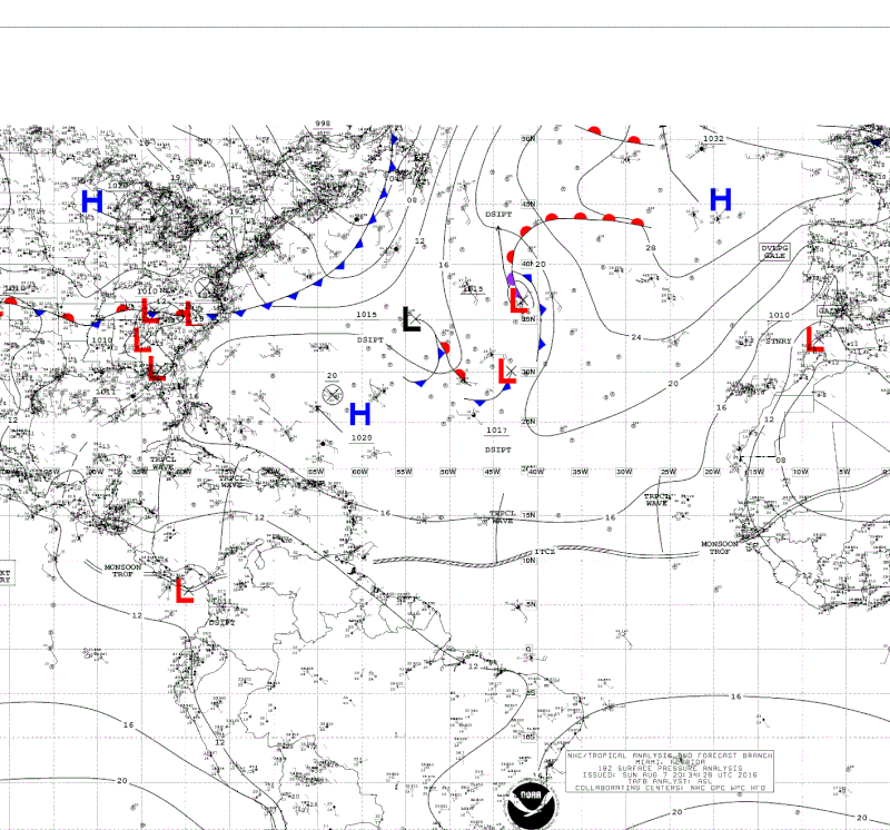
Area of convection in SE Caribbean

This is the general tropical discussion area. Anyone can take their shot at predicting a storms path.

Moderator: S2k Moderators

Forum rules

The posts in this forum are NOT official forecasts and should not be used as such. They are just the opinion of the poster and may or may not be backed by sound meteorological data. They are NOT endorsed by any professional institution or STORM2K. For official information, please refer to products from the National Hurricane Center and National Weather Service.

Help Support Storm2K
Message
Author
User avatar
NDG
S2K Supporter
S2K Supporter
Posts: 14933
Joined: Sun Jul 09, 2006 10:14 pm
Location: Orlando, FL

Re: Area of convection east of Trinidad & Tobago

#21 Postby NDG » Sun Aug 07, 2016 2:38 pm

abajan wrote:
cycloneye wrote:abajan,made an update to the title of thread as the area you mentioned at the first place has raced west and now is East of Trinidad & Tobago.


Yeah, so I noticed. It's moved so fast that I'm not even sure it's the same area or if the first one dissipated and a new one formed. :lol:


I don't think the area of disturbed wx east of Trinidad & Tobago has anything to do with the Tropical Wave Abajan mentioned yesterday morning, there's no way the tropical wave would had traveled from 37W to 58W in a day and a half.
0 likes   

User avatar
cycloneye
Admin
Admin
Posts: 139065
Age: 67
Joined: Thu Oct 10, 2002 10:54 am
Location: San Juan, Puerto Rico

Re: Area of convection east of Trinidad & Tobago

#22 Postby cycloneye » Sun Aug 07, 2016 4:29 pm

abajan wrote:
cycloneye wrote:abajan,made an update to the title of thread as the area you mentioned at the first place has raced west and now is East of Trinidad & Tobago.


Yeah, so I noticed. It's moved so fast that I'm not even sure it's the same area or if the first one dissipated and a new one formed. :lol:


Really,many times following the waves and ITCZ is confusing as sometimes Tafb introduces a wave in the MDR and other times they drop waves.This area I have followed since you made the thread and is the same area now approaching TT and northern SA you described at first post at 8N-37W.Nothing formed in ITCZ ahead of this.
0 likes   
Visit the Caribbean-Central America Weather Thread where you can find at first post web cams,radars
and observations from Caribbean basin members Click Here

User avatar
NDG
S2K Supporter
S2K Supporter
Posts: 14933
Joined: Sun Jul 09, 2006 10:14 pm
Location: Orlando, FL

Re: Area of convection east of Trinidad & Tobago

#23 Postby NDG » Sun Aug 07, 2016 5:25 pm

cycloneye wrote:
abajan wrote:
cycloneye wrote:abajan,made an update to the title of thread as the area you mentioned at the first place has raced west and now is East of Trinidad & Tobago.


Yeah, so I noticed. It's moved so fast that I'm not even sure it's the same area or if the first one dissipated and a new one formed. :lol:


Really,many times following the waves and ITCZ is confusing as sometimes Tafb introduces a wave in the MDR and other times they drop waves.This area I have followed since you made the thread and is the same area now approaching TT and northern SA you described at first post at 8N-37W.Nothing formed in ITCZ ahead of this.


You are correct, I did go back to a 48 hr satellite loop and it is the area of convection that was at 37W yesterday morning, but it is not associated with a tropical wave as abajan thought, the tropical wave is still near 45W, the same tropical wave that models have coming through the Windward and Leeward Islands by Wednesday.
1 likes   

User avatar
cycloneye
Admin
Admin
Posts: 139065
Age: 67
Joined: Thu Oct 10, 2002 10:54 am
Location: San Juan, Puerto Rico

Re: Area of convection east of Trinidad & Tobago

#24 Postby cycloneye » Sun Aug 07, 2016 5:50 pm

:uarrow: Only ITCZ related.
1 likes   
Visit the Caribbean-Central America Weather Thread where you can find at first post web cams,radars
and observations from Caribbean basin members Click Here

User avatar
Siker
Category 4
Category 4
Posts: 904
Age: 27
Joined: Thu Oct 25, 2012 7:36 pm
Location: Miami, FL

Re: Area of convection east of Trinidad & Tobago

#25 Postby Siker » Sun Aug 07, 2016 5:53 pm

~5/51 Euro ensembles develop this into a tropical storm in the Gulf.

Also a few GEFS members, now that I look at it.
0 likes   

User avatar
Kazmit
Category 5
Category 5
Posts: 1915
Age: 21
Joined: Mon Jul 25, 2016 8:49 am
Location: Williamsburg VA for college, Bermuda otherwise

Re: Area of convection east of Trinidad & Tobago

#26 Postby Kazmit » Sun Aug 07, 2016 7:30 pm

The NHC could be mentioning this soon...
0 likes   
Igor 2010, Sandy 2012, Fay 2014, Gonzalo 2014, Joaquin 2015, Nicole 2016, Humberto 2019

I am only a tropical weather enthusiast. My predictions are not official and may or may not be backed by sound meteorological data. For official information, please refer to the NHC and NWS products.

User avatar
NDG
S2K Supporter
S2K Supporter
Posts: 14933
Joined: Sun Jul 09, 2006 10:14 pm
Location: Orlando, FL

Re: Area of convection in SE Caribbean

#27 Postby NDG » Sun Aug 07, 2016 8:14 pm

Perhaps the Tropical at 45W will need its own thread fairly soon.

Image
Last edited by NDG on Sun Aug 07, 2016 8:20 pm, edited 1 time in total.
0 likes   

User avatar
Siker
Category 4
Category 4
Posts: 904
Age: 27
Joined: Thu Oct 25, 2012 7:36 pm
Location: Miami, FL

Re: Area of convection in SE Caribbean

#28 Postby Siker » Sun Aug 07, 2016 8:20 pm

NDG wrote:Perhaps the Tropical at 45W will need its own thread fairly soon.

Image


Yes, that is the actual energy that the current very weak model support develops.
0 likes   

stormlover2013
Category 5
Category 5
Posts: 2312
Joined: Thu Aug 22, 2013 12:06 pm
Location: Lumberton, Texas

Re: Area of convection in SE Caribbean

#29 Postby stormlover2013 » Sun Aug 07, 2016 8:37 pm

Can u show us the images
0 likes   

User avatar
Siker
Category 4
Category 4
Posts: 904
Age: 27
Joined: Thu Oct 25, 2012 7:36 pm
Location: Miami, FL

Re: Area of convection in SE Caribbean

#30 Postby Siker » Sun Aug 07, 2016 9:28 pm

stormlover2013 wrote:Can u show us the images


It's really not much to look at right now and I'm not sure if I'm even allowed to post the Euro ensemble images. Here is the GEFS, those lows in the Western Gulf are this system plus some added energy from the Western Caribbean:

Image
0 likes   

floridasun78
Category 5
Category 5
Posts: 3755
Joined: Sun May 17, 2009 10:16 pm
Location: miami fl

Re: Area of convection east of Trinidad & Tobago

#31 Postby floridasun78 » Sun Aug 07, 2016 10:04 pm

i see tropical wave going run into south America may bring rain to Olympics games i dont see any thing going into Caribbean that wave tooo far south go into carribbean
0 likes   

User avatar
Hurricaneman
Category 5
Category 5
Posts: 7281
Age: 43
Joined: Tue Aug 31, 2004 3:24 pm
Location: central florida

Re: Area of convection east of Trinidad & Tobago

#32 Postby Hurricaneman » Sun Aug 07, 2016 11:29 pm

The 0zGFS plows this through Hispaniola and if so this won't be much but looking at it I believe the GFS might be too far north based on the steering currents but I could be wrong

The posts in this forum are NOT official forecast and should not be used as such. They are just the opinion of the poster and may or may not be backed by sound meteorological data. They are NOT endorsed by any professional institution or STORM2K. For official information, please refer to products from the National Hurricane Center and National Weather Service
0 likes   

User avatar
AJC3
Admin
Admin
Posts: 3872
Age: 60
Joined: Tue Aug 31, 2004 7:04 pm
Location: West Melbourne, Florida
Contact:

Re: Area of convection east of Trinidad & Tobago

#33 Postby AJC3 » Sun Aug 07, 2016 11:33 pm

floridasun78 wrote:i see tropical wave going run into south America may bring rain to Olympics games i dont see any thing going into Caribbean that wave tooo far south go into carribbean


That would be a TW with one serious case of wanderlust. Rio is pretty close to the Tropic of Capricorn near 23S.
2 likes   

Dave C
S2K Supporter
S2K Supporter
Posts: 868
Joined: Thu Sep 04, 2003 4:36 pm
Location: Middleboro, Mass.(midway between Cape Cod and Boston)

Re: Area of convection east of Trinidad & Tobago

#34 Postby Dave C » Mon Aug 08, 2016 11:47 am

AJC3 wrote:
floridasun78 wrote:i see tropical wave going run into south America may bring rain to Olympics games i dont see any thing going into Caribbean that wave tooo far south go into carribbean


That would be a TW with one serious case of wanderlust. Rio is pretty close to the Tropic of Capricorn near 23S.

talk about cross equatorial flow! :D :D :D
1 likes   

User avatar
Gustywind
Category 5
Category 5
Posts: 12334
Joined: Mon Sep 03, 2007 7:29 am
Location: Baie-Mahault, GUADELOUPE

Re: Area of convection in SE Caribbean

#35 Postby Gustywind » Tue Aug 09, 2016 1:12 pm

000
AXNT20 KNHC 091805
TWDAT

Tropical Weather Discussion
NWS National Hurricane Center Miami FL
205 PM EDT TUE AUG 9 2016


Tropical wave is east of the Lesser Antilles extending from 10N-
20N with axis near 57W, moving W at 20 kt within the last 24
hours. Satellite derived data indicate the wave is in a favorable
to neutral deep layer wind shear region.
However, Saharan dry air
and dust cover most of the wave environment, in part limiting the
convection to scattered showers
from 09N-13N between 54W and 58W.
0 likes   


Return to “Talkin' Tropics”

Who is online

Users browsing this forum: cycloneye, Dean_175, Google Adsense [Bot], hurricanes1234, Sciencerocks and 184 guests