2017 EPAC Season
Moderator: S2k Moderators
Forum rules

The posts in this forum are NOT official forecasts and should not be used as such. They are just the opinion of the poster and may or may not be backed by sound meteorological data. They are NOT endorsed by any professional institution or STORM2K. For official information, please refer to products from the National Hurricane Center and National Weather Service.
-
Yellow Evan

- Professional-Met

- Posts: 15951
- Age: 25
- Joined: Fri Jul 15, 2011 12:48 pm
- Location: Henderson, Nevada/Honolulu, HI
- Contact:

Re: 2017 EPAC Season
Yellow Evan wrote::uarrow: As I posted in one of the ATL threads, GFS is moving the MJO too fast.
It probably is, I generally trust the Euro MJO more but we'll see how the upgrade performs. I'm not a huge buyer in MJO totally, a good signal but not always necessary. CCKWs can blur the true MJO sometimes too
0 likes
The above post and any post by Ntxw is NOT an official forecast and should not be used as such. It is just the opinion of the poster and may or may not be backed by sound meteorological data. It is NOT endorsed by any professional institution including Storm2k. For official information, please refer to NWS products.
Help support Storm2K!
-
Kingarabian

- S2K Supporter

- Posts: 15432
- Joined: Sat Aug 08, 2009 3:06 am
- Location: Honolulu, Hawaii
Re: 2017 EPAC Season
Ntxw wrote:Way out there on GFS and probably won't be the exact storm in fantasy range anyway. But hey, since EPAC is a cyclone factory right now..why not Jova?
[img]http://i63.tinypic.com/rmqv6p.png[/mg]
By the time this outbreak is over and If these systems do not bust, we should see at least our J system, if not K.
0 likes
RIP Kobe Bryant
-
Kingarabian
- S2K Supporter
- Posts: 15432
- Joined: Sat Aug 08, 2009 3:06 am
- Location: Honolulu, Hawaii
Re: 2017 EPAC Season
We should all monitor the Atlantic MDR. Usually systems that can't develop there have their Vorts making it across the Caribbean and in the EPac.
0 likes
RIP Kobe Bryant
-
dexterlabio
- Category 5

- Posts: 3406
- Joined: Sat Oct 24, 2009 11:50 pm
Re: 2017 EPAC Season
Ntxw wrote:Yellow Evan wrote::uarrow: As I posted in one of the ATL threads, GFS is moving the MJO too fast.
It probably is, I generally trust the Euro MJO more but we'll see how the upgrade performs. I'm not a huge buyer in MJO totally, a good signal but not always necessary. CCKWs can blur the true MJO sometimes too
BTW where are you getting the MJO updates and forecast? On the CPC website the ECMWF model forecasts for the MJO are still unavailable, the last updated data was from 10 days ago.
0 likes
Personal Forecast Disclaimer:
The posts in this forum are NOT official forecast and should not be used as such. They are just the opinion of the poster and may or may not be backed by sound meteorological data. They are NOT endorsed by any professional institution or storm2k.org. For official information, please refer to the NHC and NWS products.
The posts in this forum are NOT official forecast and should not be used as such. They are just the opinion of the poster and may or may not be backed by sound meteorological data. They are NOT endorsed by any professional institution or storm2k.org. For official information, please refer to the NHC and NWS products.
-
SuperMarioBros99thx

- Tropical Storm

- Posts: 192
- Age: 22
- Joined: Sat Jul 08, 2017 7:38 am
- Location: Banjarmasin, Indonesia
Re: 2017 EPAC Season
Ntxw wrote:Way out there on GFS and probably won't be the exact storm in fantasy range anyway. But hey, since EPAC is a cyclone factory right now..why not Jova?

I bet when that happens it's Hurricane Irwin!
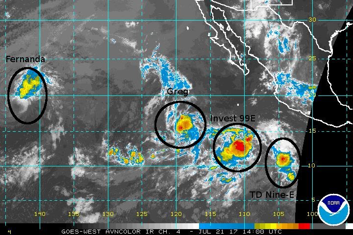
Reasons is that Invest 99E is pretty unlikely to be ever a TS given it's close position into Greg. Proximity to Greg might turn down, if not turn off that TD.
0 likes
My opinions are mine and SHOULD not be treated as an official source of information. PLEASE see National Hurricane Center, or any other meteorological agencies, for that matter. By the way, I was born and came from Indonesia, which is rarely hit by tropical cyclones, but regardless, I have LOTS of interest in meteorology.

-
gatorcane

- S2K Supporter
- Posts: 23499
- Age: 46
- Joined: Sun Mar 13, 2005 3:54 pm
- Location: Boca Raton, FL
Re: 2017 EPAC Season
It certainly is acting very "El-Nino-ish" with this hyperactive EPAC. To think just a month ago, it didn't look like it would be as active as last year and now there are so many systems it is hard to keep track of them all.
0 likes
Re: 2017 EPAC Season
gatorcane wrote:It certainly is acting very "El-Nino-ish" with this hyperactive EPAC. To think just a month ago, it didn't look like it would be as active as last year and now there are so many systems it is hard to keep track of them all.
Even though El Nino seasons can be big seasons for the EPAC, it is better correlated to more intense storms. +PDO is a better indicator as many mentioned earlier in the season. The stretch that the EPAC is going through is comparable to 2003-2005 in the Atlantic. Most of the top EPAC seasons are between Nino events during +PDO such as 1983, 1985, 1990, 1992, 1993 etc. 2015 was anomalous on its own.
2 likes
The above post and any post by Ntxw is NOT an official forecast and should not be used as such. It is just the opinion of the poster and may or may not be backed by sound meteorological data. It is NOT endorsed by any professional institution including Storm2k. For official information, please refer to NWS products.
Help support Storm2K!
Help support Storm2K!

Re: 2017 EPAC Season
gatorcane wrote:It certainly is acting very "El-Nino-ish" with this hyperactive EPAC. To think just a month ago, it didn't look like it would be as active as last year and now there are so many systems it is hard to keep track of them all.
Last year was a La Niña and there were 5 hurricanes during the month of July with 3 of them being major hurricanes. PDO has a lot more to do with it like Ntxw mentioned.
1 likes
-
gatorcane
- S2K Supporter
- Posts: 23499
- Age: 46
- Joined: Sun Mar 13, 2005 3:54 pm
- Location: Boca Raton, FL
Re: 2017 EPAC Season
The GFS has been consistently showing another big one in the long-range:

0 likes
-
Kingarabian
- S2K Supporter
- Posts: 15432
- Joined: Sat Aug 08, 2009 3:06 am
- Location: Honolulu, Hawaii
-
TheStormExpert

- Category 5
- Posts: 8487
- Age: 30
- Joined: Wed Feb 16, 2011 5:38 pm
- Location: Palm Beach Gardens, FL
Re: 2017 EPAC Season
Kingarabian wrote:All these systems are struggling with shear.
Could that mean favorable conditions are located in the western half of the east Pacific and the central Pacific like you'd see in a Modoki El Niño?
1 likes
The following post is NOT an official forecast and should not be used as such. It is just the opinion of the poster and may or may not be backed by sound meteorological data. It is NOT endorsed by storm2k.org.
Re: 2017 EPAC Season
Kingarabian wrote:All these systems are struggling with shear.
They are all so close to each other to begin with
1 likes
The above post and any post by Ntxw is NOT an official forecast and should not be used as such. It is just the opinion of the poster and may or may not be backed by sound meteorological data. It is NOT endorsed by any professional institution including Storm2k. For official information, please refer to NWS products.
Help support Storm2K!
Help support Storm2K!
-
WeatherGuesser
- Category 5
- Posts: 2672
- Joined: Tue Jun 29, 2010 6:46 am
-
TropicalAnalystwx13

- Category 5
- Posts: 2109
- Age: 26
- Joined: Tue Jul 19, 2011 8:20 pm
- Location: Wilmington, NC
- Contact:
Re: 2017 EPAC Season
There might be room for one more storm this month after Hilary/Irwin, and then it looks like things may potentially calm down. Fits well with climatology, where the East Pacific has a peak in mid/late July and then a lull until late August.
3 likes
-
Kingarabian
- S2K Supporter
- Posts: 15432
- Joined: Sat Aug 08, 2009 3:06 am
- Location: Honolulu, Hawaii
Re: 2017 EPAC Season
TropicalAnalystwx13 wrote:There might be room for one more storm this month after Hilary/Irwin, and then it looks like things may potentially calm down. Fits well with climatology, where the East Pacific has a peak in mid/late July and then a lull until late August.
There will be another low pressure area after Hillary/Irwin. Models on and off about developing it.
0 likes
RIP Kobe Bryant
-
Kingarabian
- S2K Supporter
- Posts: 15432
- Joined: Sat Aug 08, 2009 3:06 am
- Location: Honolulu, Hawaii
Re: 2017 EPAC Season
If the GFS is right, Irwin and Hillary will both be major hurricanes within 72 hours and keeps them strong for another 4 days. We could easily see 100 ACE if that musters.

0 likes
RIP Kobe Bryant
Re: 2017 EPAC Season
GFS is still hinting at potential Jova, it's been there pretty persistently. Looking at 200hpa velocities, the reason Greg, Irwin and the waves before it were facing some problems is the nature of the somewhat unfavorable background but with such vigorous waves established they were able to make do. It's going to switch more favorable though late July and early August as the rising motion from the WPAC makes its way eastward.

0 likes
The above post and any post by Ntxw is NOT an official forecast and should not be used as such. It is just the opinion of the poster and may or may not be backed by sound meteorological data. It is NOT endorsed by any professional institution including Storm2k. For official information, please refer to NWS products.
Help support Storm2K!
Help support Storm2K!
-
cycloneye

- Admin

- Posts: 139019
- Age: 67
- Joined: Thu Oct 10, 2002 10:54 am
- Location: San Juan, Puerto Rico
Re: 2017 EPAC Season
18z GFS has back the long range strong Hurricane Jova.

1 likes
Visit the Caribbean-Central America Weather Thread where you can find at first post web cams,radars
and observations from Caribbean basin members Click Here
and observations from Caribbean basin members Click Here
Who is online
Users browsing this forum: Chris90, KirbyDude25, Sciencerocks and 59 guests