2017 WPAC Season
Moderator: S2k Moderators
Forum rules

The posts in this forum are NOT official forecasts and should not be used as such. They are just the opinion of the poster and may or may not be backed by sound meteorological data. They are NOT endorsed by any professional institution or STORM2K. For official information, please refer to products from the National Hurricane Center and National Weather Service.
-
dexterlabio
- Category 5

- Posts: 3406
- Joined: Sat Oct 24, 2009 11:50 pm
Re: 2017 WPAC Season
Looks like we will be having a trough of low pressure systems extending from the southwest (SCS) to far northeast (subtropic Western Pacific), based on the latest Euro and GFS runs. Isn't it familiar?
0 likes
Personal Forecast Disclaimer:
The posts in this forum are NOT official forecast and should not be used as such. They are just the opinion of the poster and may or may not be backed by sound meteorological data. They are NOT endorsed by any professional institution or storm2k.org. For official information, please refer to the NHC and NWS products.
The posts in this forum are NOT official forecast and should not be used as such. They are just the opinion of the poster and may or may not be backed by sound meteorological data. They are NOT endorsed by any professional institution or storm2k.org. For official information, please refer to the NHC and NWS products.
-
1900hurricane

- Category 5
- Posts: 6044
- Age: 32
- Joined: Fri Feb 06, 2015 12:04 pm
- Location: Houston, TX
- Contact:
Re: 2017 WPAC Season
0 likes
Contract Meteorologist. TAMU & MSST. Fiercely authentic, one of a kind. We are all given free will, so choose a life meant to be lived. We are the Masters of our own Stories.
Opinions expressed are mine alone.
Follow me on Twitter at @1900hurricane : Read blogs at https://1900hurricane.wordpress.com/
Opinions expressed are mine alone.
Follow me on Twitter at @1900hurricane : Read blogs at https://1900hurricane.wordpress.com/
-
1900hurricane
- Category 5
- Posts: 6044
- Age: 32
- Joined: Fri Feb 06, 2015 12:04 pm
- Location: Houston, TX
- Contact:
Re: 2017 WPAC Season
Just finished my latest blog post. With the most to discuss so far this season, it's unsurprisingly the longest one since I started hosting it on WordPress. In it, I discuss Tropical Depression 95W, Invest 96W, Invest 97W, the convective complex just off Kyushu, and a possible future system in the Philippine Sea.
Western Pacific Tropical Analysis: July 19, 2017

Western Pacific Tropical Analysis: July 19, 2017
0 likes
Contract Meteorologist. TAMU & MSST. Fiercely authentic, one of a kind. We are all given free will, so choose a life meant to be lived. We are the Masters of our own Stories.
Opinions expressed are mine alone.
Follow me on Twitter at @1900hurricane : Read blogs at https://1900hurricane.wordpress.com/
Opinions expressed are mine alone.
Follow me on Twitter at @1900hurricane : Read blogs at https://1900hurricane.wordpress.com/
-
dexterlabio
- Category 5
- Posts: 3406
- Joined: Sat Oct 24, 2009 11:50 pm
Re: 2017 WPAC Season
Aside from the potential intense typhoon with subtropical origin, the new GFS and new Euro have different solutions with regards of the future storms popping out of the monsoon trough. Although the GFS mean ensemble has quite the same picture as the Euro.
0 likes
Personal Forecast Disclaimer:
The posts in this forum are NOT official forecast and should not be used as such. They are just the opinion of the poster and may or may not be backed by sound meteorological data. They are NOT endorsed by any professional institution or storm2k.org. For official information, please refer to the NHC and NWS products.
The posts in this forum are NOT official forecast and should not be used as such. They are just the opinion of the poster and may or may not be backed by sound meteorological data. They are NOT endorsed by any professional institution or storm2k.org. For official information, please refer to the NHC and NWS products.

Re: 2017 WPAC Season
Yeah the latest EURO has a strong typhoon making landfall in Taiwan originating from the P.I sea. Has it at 975mb at landfall.
It has another system developing in the SCS but has it absorbed.
It has another system developing in the SCS but has it absorbed.
0 likes
Remember, all of my post aren't official. For official warnings and discussions, Please refer to your local NWS products...
NWS for the Western Pacific
https://www.weather.gov/gum/
NWS for the Western Pacific
https://www.weather.gov/gum/
Re: 2017 WPAC Season
euro6208 wrote:Yeah the latest EURO has a strong typhoon making landfall in Taiwan originating from the P.I sea. Has it at 975mb at landfall.
It has another system developing in the SCS but has it absorbed.
It does have some support from JMA and NAVGEM.
0 likes
Remember, all of my post aren't official. For official warnings and discussions, Please refer to your local NWS products...
NWS for the Western Pacific
https://www.weather.gov/gum/
NWS for the Western Pacific
https://www.weather.gov/gum/
Re: 2017 WPAC Season
GFS has something too but more sooner. It has a small compact TC developing and hitting Leyte Philippines.

0 likes
Remember, all of my post aren't official. For official warnings and discussions, Please refer to your local NWS products...
NWS for the Western Pacific
https://www.weather.gov/gum/
NWS for the Western Pacific
https://www.weather.gov/gum/
Re: 2017 WPAC Season
NWS in their latest outlook. Mentions the Western Micronesia system.
538
FXPQ60 PGUM 200815 AAA
AFDPQ
Area Forecast Discussion...Updated
National Weather Service Tiyan GU
318 PM ChST Thu Jul 20 2017
.Marianas Synopsis...
Satellite shows fair skies over the local region with significant
weather farther to the south and southwest. VAD gradient winds are
east about 15 kt. Ipan Buoy shows combined seas near 4 feet and
Saipan and Ritidian Buoys show 2 to 3 ft.
&&
.Discussion...
Introduced isolated thunderstorms mainly Sunday through Monday.
For the near term; Relatively dry mid-levels and gentle to
moderate trade winds are expected the next couple days. Mostly
sunny and hot conditions for the Liberation Day Parade tomorrow.
Then; Models show increasing moisture arriving from the southeast
along with lighter surface winds by Sunday through Monday, and
this could trigger a few thunderstorms, especially during the
afternoon hours over Guam.
&&
.Eastern Micronesia and Chuuk...
Eastern half of Micronesia south of 10N is dominated primarily by
trade-wind convergence and upper-level westerly shear with a
couple of north- south orientated waves just west of Chuuk near
151E, also near 168E, between Kosrae and the Marshalls, and a
weak wave near the dateline. In other words, no significant
organized system approaching any of our sites at this time. Expect
all sites to be mostly cloudy with short periods between waves
with breaks in the clouds, especially between waves. As the case
has been all season...the primary models used: GFS, ECMWF and the
NAVGEM keep an active ITCZ pattern but rarely agree on any
particular weather-specific event for any site. Currently, Majuro
looks to be moving from an enhanced area of precipitation to a
temporary lull on Friday and back to scattered showers on Saturday
with the next impulse. Kosrae looks to be most likely under the
greatest influence of the wave just passing Majuro on Friday.
For Pohnpei, models show a more prolonged rain event over the
weekend due to a combination of the next wave and the north-south
position of the ITCZ. Finally, Chuuk`s forecast is less certain
since it is located between the monsoon regime to the west and the
ITCZ to the east. I have kept with the previous forecast although
the models are less certain. For now, expect scattered showers
through Saturday night. Very little confidence here, though.
Seas at all locations look to remain below 4 to 6 feet.
&&
.Western Micronesia...
Forecast scenario for Yap and the Republic of Palau is dominated
by the future positioning of the monsoon trough to the south and
the development, if any, of the weak circulation currently
located south of Yap Island near 6N 139E. All three of the above
mentioned models develop a circulation out to the northwest of Yap
and Koror by the end of the weekend. The forecast problem is
whether this is the same circulation as just mentioned, or a
combination of the westerly surge southwest of Palau and the
integration of a weak circulation trying to develop just to the
east of Luzon and the circulation south of Yap. This matters for
both the timing of rain events and the changes in wind direction
at Palau (not as much of a concern for Yap). I went with the
combined GFS and ECMWF forecast which keeps the circulation south
of Yap and moving towards the northwest...thus the change in the
wind forecast direction from the previous forecast period for
Koror. However...the NAVGEM does offer a solution that would keep
the circulation at the current 6N while drifting to the west and
south of Palau before intensifying and moving to the north and
then east of Luzon. This scenario would change the forecasted wind
direction back to the northeast, and give less winds and
precipitation overall. Hopefully the next run...and movement of
the circulation...help clarify the situation.
In the mean time, I changed the seas forecast format for the
later time periods for Koror to show the predicted WW3 onset of a
small but significant southwest swell. This would be a change to
the past pattern.
&&
.GUM WATCHES/WARNINGS/ADVISORIES...
GU...None.
Marianas Waters...None.
&&
$$
Simpson/Edson
0 likes
Remember, all of my post aren't official. For official warnings and discussions, Please refer to your local NWS products...
NWS for the Western Pacific
https://www.weather.gov/gum/
NWS for the Western Pacific
https://www.weather.gov/gum/
Re: 2017 WPAC Season

0 likes
Remember, all of my post aren't official. For official warnings and discussions, Please refer to your local NWS products...
NWS for the Western Pacific
https://www.weather.gov/gum/
NWS for the Western Pacific
https://www.weather.gov/gum/
-
mrbagyo

- Category 5
- Posts: 3614
- Age: 31
- Joined: Thu Apr 12, 2012 9:18 am
- Location: 14.13N 120.98E
- Contact:
Re: 2017 WPAC Season
An area of persistent convection can be spotted just east of Luzon. I wont be surprised if we'll have 2 additional invest by tomorrow coming from this system and the other one near Palau which is embedded in a Monsoon trough. One of them might get absorbed by the other though.
0 likes
The posts in this forum are NOT official forecast and should not be used as such. They are just the opinion of the poster and may or may not be backed by sound meteorological data. They are NOT endorsed by any professional institution or storm2k.org. For official information, please refer to RSMC, NHC and NWS products.
Re: 2017 WPAC Season
.Western Micronesia for Yap and Koror...
ASCAT satellite imagery from yesterday afternoon and last night
strongly suggests a broad circulation still exist along the
southeastern end of a monsoon trough southeast of Koror near 5N137E.
Fresh converging northwest winds are also seen just west and south
of Koror which coincides with widespread deep convection seen on the
latest IR satellite loops. No major development is anticipated for
this circulation at least thru Saturday. With this mind, winds near
its center should remain gentle as it passes very close to Koror
tonight and Saturday. Therefore, mainly isolated convection is
forecast for the capital thru Saturday. For Yap, converging trade
winds northeast of the circulation and monsoon trough will continue
to trigger periodic showers and thunderstorms thru Saturday.
Model consensus is predicting this circulation to develop into a
stronger monsoonal system northwest of Koror later this weekend. If
so, moderate to even fresh convergent monsoonal southwest to south
winds could materialize across the Republic of Palau and western Yap
State. Under this scenario, locally heavy showers and scattered
thunderstorms are possible but decided not to include into the mid-
term forecast yet as future shifts will fine tune the onset of
inclement weather. A southwest to south swell is also probable which
will cause seas and surf to rise across far western Micronesia. For
now, have kept elevated seas near Palau thru Monday and Yap thru
Sunday night. As this potential monsoonal system drifts farther
northwestward toward the Philippines next week, a surface ridge
should form and introduce a gradual drying trend.
0 likes
Remember, all of my post aren't official. For official warnings and discussions, Please refer to your local NWS products...
NWS for the Western Pacific
https://www.weather.gov/gum/
NWS for the Western Pacific
https://www.weather.gov/gum/
-
1900hurricane
- Category 5
- Posts: 6044
- Age: 32
- Joined: Fri Feb 06, 2015 12:04 pm
- Location: Houston, TX
- Contact:
Re: 2017 WPAC Season
0 likes
Contract Meteorologist. TAMU & MSST. Fiercely authentic, one of a kind. We are all given free will, so choose a life meant to be lived. We are the Masters of our own Stories.
Opinions expressed are mine alone.
Follow me on Twitter at @1900hurricane : Read blogs at https://1900hurricane.wordpress.com/
Opinions expressed are mine alone.
Follow me on Twitter at @1900hurricane : Read blogs at https://1900hurricane.wordpress.com/
Re: 2017 WPAC Season
mrbagyo wrote:An area of persistent convection can be spotted just east of Luzon. I wont be surprised if we'll have 2 additional invest by tomorrow coming from this system and the other one near Palau which is embedded in a Monsoon trough. One of them might get absorbed by the other though.
Yup now an invest.
98W INVEST
0 likes
Remember, all of my post aren't official. For official warnings and discussions, Please refer to your local NWS products...
NWS for the Western Pacific
https://www.weather.gov/gum/
NWS for the Western Pacific
https://www.weather.gov/gum/
Re: 2017 WPAC Season
Yeah except for 98W, the others are at and probably TS's already. JMA and JTWC are too much dvorak driven and always behind on things. So disappointed with them.
0 likes
Remember, all of my post aren't official. For official warnings and discussions, Please refer to your local NWS products...
NWS for the Western Pacific
https://www.weather.gov/gum/
NWS for the Western Pacific
https://www.weather.gov/gum/
Re: 2017 WPAC Season
0 likes
Remember, all of my post aren't official. For official warnings and discussions, Please refer to your local NWS products...
NWS for the Western Pacific
https://www.weather.gov/gum/
NWS for the Western Pacific
https://www.weather.gov/gum/

Re: 2017 WPAC Season
GFS went nuts for Noru

That's Patricia's pressure..caveat is long range
That's Patricia's pressure..caveat is long range
1 likes
The above post and any post by Ntxw is NOT an official forecast and should not be used as such. It is just the opinion of the poster and may or may not be backed by sound meteorological data. It is NOT endorsed by any professional institution including Storm2k. For official information, please refer to NWS products.
Help support Storm2K!
-
Kingarabian

- S2K Supporter

- Posts: 15434
- Joined: Sat Aug 08, 2009 3:06 am
- Location: Honolulu, Hawaii
Re: 2017 WPAC Season
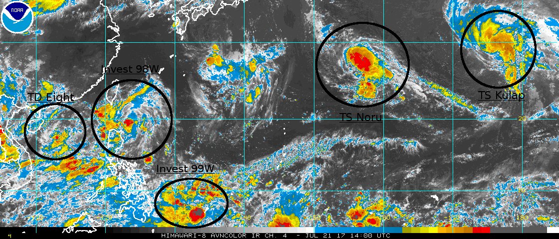
Kingarabian wrote:Systems lined up in the WPac and EPAC. A sight to see.


2 likes
Remember, all of my post aren't official. For official warnings and discussions, Please refer to your local NWS products...
NWS for the Western Pacific
https://www.weather.gov/gum/
NWS for the Western Pacific
https://www.weather.gov/gum/
Re: 2017 WPAC Season
000
FXPQ60 PGUM 210818
AFDPQ
Area Forecast Discussion
National Weather Service Tiyan GU
615 PM ChST Fri Jul 21 2017
.Marianas Synopsis...
Satellite shows quite a bit of high clouds over the area while
radar shows only isolated showers nearby. A developing disturbance
is near Koror and a Special Weather Statement was issued for that
area. VAD gradient winds are east-southeast 12 to 15 kt. Ipan
Buoy shows combined seas around 4 feet, and Saipan and Ritidian
Buoys show 2 to 3 ft.
&&
.Discussion...
Refreshed wind and wave grids based on latest GFS Model. Isolated
thunderstorms are still expected mainly Sunday through Monday. High
cloudiness was more than expected today, but mid-levels will remain
relatively dry through Saturday. Models show increasing moisture
arriving from the southeast on Sunday along with light southeast
surface winds by Monday, turning south-to-variable at times about
Tuesday or Wednesday. Although a little drier weather is expected
Wednesday, the GFS model shows active weather to our southwest and
west, and we could have southwest winds later in the week.
&&
.Marine...
Introduced a small southwest swell on Tuesday for secondary wave
grids based on WW3 Guidance, which is itself based on developments
of the disturbance near Palau, and other things. There is already
southwest monsoon flow over Palau, and I want to account for a
possible first episode of southwest waves affecting our Marianas
shorelines this week.
&&
.Eastern Micronesia and Chuuk...
Trade-wind convergence will generate scattered showers and isolated
thunderstorms across Kosrae and Majuro tonight. A weak surface trough
will develop across eastern Micronesia and bring scattered showers
and isolated thunderstorms to Pohnpei and Chuuk Saturday and Saturday
night. Another weak surface trough will bring scattered showers to
Kosrae Monday. A combination of trade-wind convergence and weak
surface troughs will keep skies mostly cloudy and produce on and
off showers and isolated thunderstorms across eastern Micronesia
through the remainder of the forecast.
&&
.GUM WATCHES/WARNINGS/ADVISORIES...
GU...None.
Marianas Waters...None.
&&
$$
Simpson/Ziobro
0 likes
Remember, all of my post aren't official. For official warnings and discussions, Please refer to your local NWS products...
NWS for the Western Pacific
https://www.weather.gov/gum/
NWS for the Western Pacific
https://www.weather.gov/gum/