

2017 WPAC Season
Moderator: S2k Moderators
Forum rules

The posts in this forum are NOT official forecasts and should not be used as such. They are just the opinion of the poster and may or may not be backed by sound meteorological data. They are NOT endorsed by any professional institution or STORM2K. For official information, please refer to products from the National Hurricane Center and National Weather Service.
Re: 2017 WPAC Season
0 likes
Remember, all of my post aren't official. For official warnings and discussions, Please refer to your local NWS products...
NWS for the Western Pacific
https://www.weather.gov/gum/
NWS for the Western Pacific
https://www.weather.gov/gum/
-
Digital-TC-Chaser
Re: 2017 WPAC Season
https://www.facebook.com/northauschaser ... 6559363211
With the early arrival of the wet season over the top--end the stronger highs that come with it should start pushing through now. And may start to stir up things to the north of the EQ also.
With the early arrival of the wet season over the top--end the stronger highs that come with it should start pushing through now. And may start to stir up things to the north of the EQ also.
0 likes
Re: 2017 WPAC Season

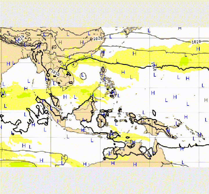
Satellite imagery, on Oct 3, reveals a trough of low pressure with convection near 15N-150E over the west Pacific. Model guidance supports slow TC development, albeit with moderate confidence, over the west Pacific (10 to 20N/120 to 140E) during Week-1. The moderate confidence for TC development is maintained for the west Pacific during Week-2 and expanded to include the South China Sea, based on the GEFS model guidance and climatology.

0 likes
Remember, all of my post aren't official. For official warnings and discussions, Please refer to your local NWS products...
NWS for the Western Pacific
https://www.weather.gov/gum/
NWS for the Western Pacific
https://www.weather.gov/gum/
-
Digital-TC-Chaser
Re: 2017 WPAC Season
Yup NAVGEM joins EURO and GFS on the SCS system. EURO is much weaker passing south of Hainan Island while GFS is much stronger into Vietnam. Probrably near typhoon strength.
0 likes
Remember, all of my post aren't official. For official warnings and discussions, Please refer to your local NWS products...
NWS for the Western Pacific
https://www.weather.gov/gum/
NWS for the Western Pacific
https://www.weather.gov/gum/
Re: 2017 WPAC Season
Very long range but this is what GFS has for the WPAC. Most active I've seen in weeks.  It has multiple systems in the area with a powerful typhoon again in the SCS. The others all the way to Guam remains weak.

1 likes
Remember, all of my post aren't official. For official warnings and discussions, Please refer to your local NWS products...
NWS for the Western Pacific
https://www.weather.gov/gum/
NWS for the Western Pacific
https://www.weather.gov/gum/
-
mrbagyo

- Category 5

- Posts: 3614
- Age: 31
- Joined: Thu Apr 12, 2012 9:18 am
- Location: 14.13N 120.98E
- Contact:
Re: 2017 WPAC Season
(-_-)...zzzZz -> (°o°)
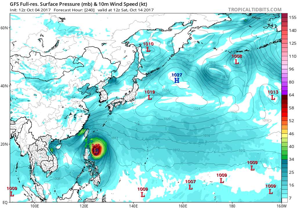
10/04 - 12z 240hrs
10/04 - 18z 240hrs
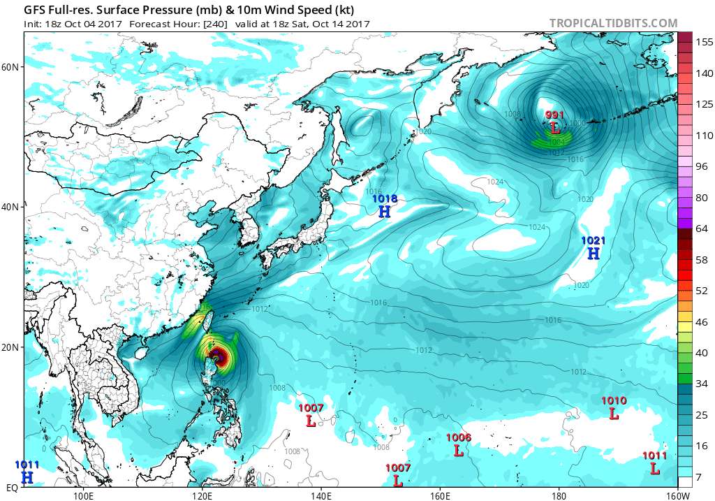
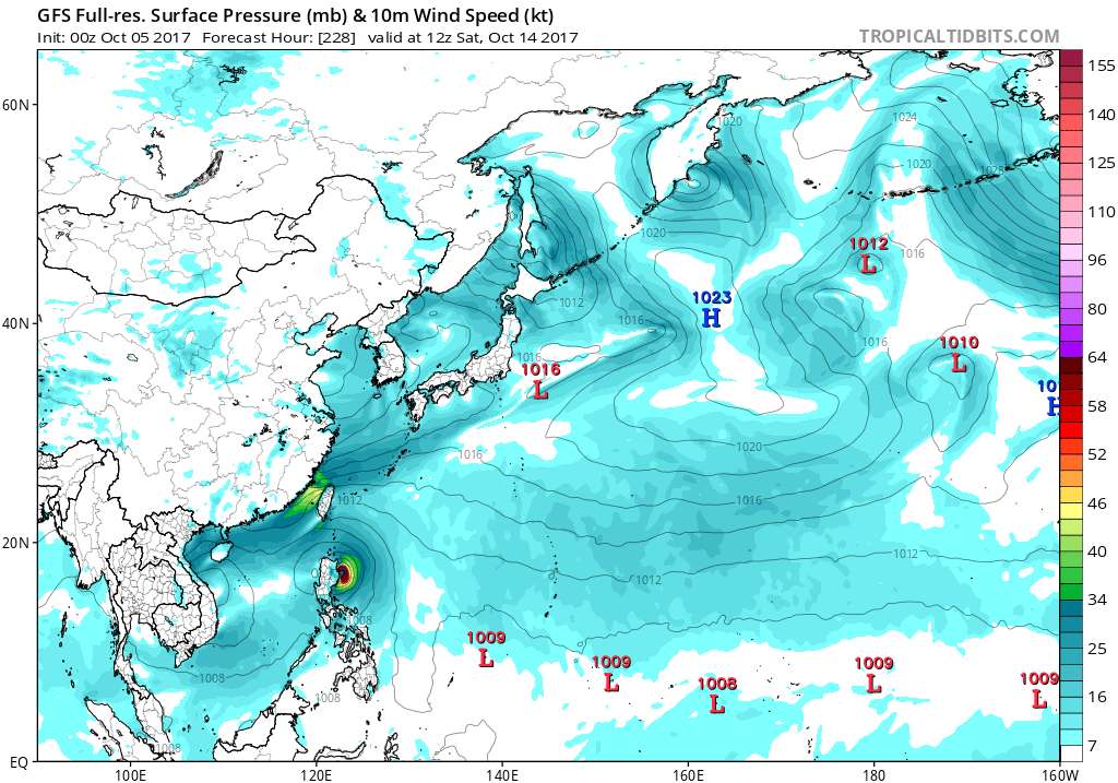
edit: 05 00z just came out - a bit more south but still a hit in N. Luzon.
edit: gone on 10/05 06z run -_- zZzZ
10/04 - 12z 240hrs
10/04 - 18z 240hrs
edit: 05 00z just came out - a bit more south but still a hit in N. Luzon.
edit: gone on 10/05 06z run -_- zZzZ
0 likes
The posts in this forum are NOT official forecast and should not be used as such. They are just the opinion of the poster and may or may not be backed by sound meteorological data. They are NOT endorsed by any professional institution or storm2k.org. For official information, please refer to RSMC, NHC and NWS products.
-
mrbagyo
- Category 5
- Posts: 3614
- Age: 31
- Joined: Thu Apr 12, 2012 9:18 am
- Location: 14.13N 120.98E
- Contact:
Re: 2017 WPAC Season
0 likes
The posts in this forum are NOT official forecast and should not be used as such. They are just the opinion of the poster and may or may not be backed by sound meteorological data. They are NOT endorsed by any professional institution or storm2k.org. For official information, please refer to RSMC, NHC and NWS products.
Re: 2017 WPAC Season
euro6208 wrote:Yup NAVGEM joins EURO and GFS on the SCS system. EURO is much weaker passing south of Hainan Island while GFS is much stronger into Vietnam. Probrably near typhoon strength.
Well...The models sided with the EURO.
0 likes
Remember, all of my post aren't official. For official warnings and discussions, Please refer to your local NWS products...
NWS for the Western Pacific
https://www.weather.gov/gum/
NWS for the Western Pacific
https://www.weather.gov/gum/
Re: 2017 WPAC Season
The GFS and now NAVGEM are still in agreement with that SCS system I posted a while back. GFS has it fairly strong and track similiar to Typhoon Doksuri last month.
0 likes
Remember, all of my post aren't official. For official warnings and discussions, Please refer to your local NWS products...
NWS for the Western Pacific
https://www.weather.gov/gum/
NWS for the Western Pacific
https://www.weather.gov/gum/
Re: 2017 WPAC Season


12Z and 18Z GFS shows even more activity long range. It has 2 more including a typhoon in the P.I sea.
0 likes
Remember, all of my post aren't official. For official warnings and discussions, Please refer to your local NWS products...
NWS for the Western Pacific
https://www.weather.gov/gum/
NWS for the Western Pacific
https://www.weather.gov/gum/
Re: 2017 WPAC Season

French scientists on Guam use experimental balloons to study tropical cyclones
The researchers are scheduled to be here until Oct. 21, and up to three balloon releases may be conducted.
Interesting. I hope something do forms or else they won't be able to release any balloons. Has anyone got any update from Japan's planned recon return this season? It's already October.
French Researchers on Guam for Tropical Cyclone Research
Guam will serve as the base of operations during the next few weeks for a team of scientists and technicians from France. The team aims to release miniature blimps, or AeroClippers, from Guam, with the goal of being drawn into a developing tropical cyclone. Based on climatological studies, Guam was selected as one of the most favorable sites in the world for the AeroClipper to be captured by a tropical cyclone.
The goal of this research is to provide continuous in-situ measurements, such as location and surface pressure, in order to monitor real-time changes in the track and intensity of tropical cyclones. This data will be assimilated into computer models to ultimately improve the forecasts. The AeroClipper can simultaneously record measurements of the ocean surface and atmosphere over long distances in areas where conventional observations are less concentrated. The AeroClipper is tracked via GPS and can send data for up to 30 days.
The operational period is October 4th through 21st. Releases from the Hagatna Boat Basin may begin as early as this weekend; up to 3 releases may occur. The AeroClipper will be tethered to a free-floating guide-rope which will keep it afloat around 100 feet above the surface.
NWS Guam meteorologists are working closely with this team, providing daily weather reports on current conditions and a tropical weather outlook.
Folks and motorists in and around Hagatna will notice little impact to daily routines. Once a mission window is set for a release, the AeroClipper will be escorted from the warehouse along Marine Corps Drive in Hagatna, across the highway to the boat basin. GPD will provide assistance for crossing the highway and GFD will provide a safety zone in the water. The USCG will release a broadcast notice to Mariners in conjunction with a Marine Safety Information Bulletin on this weather balloon.
Last edited by euro6208 on Fri Oct 06, 2017 8:43 am, edited 2 times in total.
0 likes
Remember, all of my post aren't official. For official warnings and discussions, Please refer to your local NWS products...
NWS for the Western Pacific
https://www.weather.gov/gum/
NWS for the Western Pacific
https://www.weather.gov/gum/
-
dexterlabio
- Category 5
- Posts: 3406
- Joined: Sat Oct 24, 2009 11:50 pm
Re: 2017 WPAC Season
Tempting fate, it looks like the WPAC basin is destined to not have its tropical cyclones studied through recon. Just when recon missions are reported this year, WPAC decides to go quiet.
1 likes
Personal Forecast Disclaimer:
The posts in this forum are NOT official forecast and should not be used as such. They are just the opinion of the poster and may or may not be backed by sound meteorological data. They are NOT endorsed by any professional institution or storm2k.org. For official information, please refer to the NHC and NWS products.
The posts in this forum are NOT official forecast and should not be used as such. They are just the opinion of the poster and may or may not be backed by sound meteorological data. They are NOT endorsed by any professional institution or storm2k.org. For official information, please refer to the NHC and NWS products.
Re: 2017 WPAC Season
0 likes
Remember, all of my post aren't official. For official warnings and discussions, Please refer to your local NWS products...
NWS for the Western Pacific
https://www.weather.gov/gum/
NWS for the Western Pacific
https://www.weather.gov/gum/
Re: 2017 WPAC Season

Looking very active out there in the last week as the MJO moves through.
0 likes
Remember, all of my post aren't official. For official warnings and discussions, Please refer to your local NWS products...
NWS for the Western Pacific
https://www.weather.gov/gum/
NWS for the Western Pacific
https://www.weather.gov/gum/
-
doomhaMwx

- Category 5
- Posts: 2398
- Age: 25
- Joined: Tue Apr 18, 2017 4:01 am
- Location: Baguio/Benguet, Philippines
- Contact:
Re: 2017 WPAC Season
We currently have Invest 95W, 96W, 97W
Additional Invest areas may form or get designated over the Philippine Sea and/or South China Sea within the next few days... As mentioned in another thread by another member, it appears though that the South China Sea will be the most favorable area in the basin this week and possibly through next week for tropical disturbances/cyclones to develop/intensify further...
Additional Invest areas may form or get designated over the Philippine Sea and/or South China Sea within the next few days... As mentioned in another thread by another member, it appears though that the South China Sea will be the most favorable area in the basin this week and possibly through next week for tropical disturbances/cyclones to develop/intensify further...
Digital-TC-Chaser wrote:Jason Nicholls @jnmet
More
Conditions looking favourable for cyclone development in the South #China Sea late next week.

0 likes
Like my content? Consider giving a tip.
-
Digital-TC-Chaser
-
mrbagyo
- Category 5
- Posts: 3614
- Age: 31
- Joined: Thu Apr 12, 2012 9:18 am
- Location: 14.13N 120.98E
- Contact:
Re: 2017 WPAC Season
Latest ECMWF 00z run has an intensifying TC moving towards Luzon @ 240 hrs - almost exactly 1 year after Haima ravaged the area. Still watching for guidance consistency though
0 likes
The posts in this forum are NOT official forecast and should not be used as such. They are just the opinion of the poster and may or may not be backed by sound meteorological data. They are NOT endorsed by any professional institution or storm2k.org. For official information, please refer to RSMC, NHC and NWS products.
Re: 2017 WPAC Season
mrbagyo wrote:
Latest ECMWF 00z run has an intensifying TC moving towards Luzon @ 240 hrs - almost exactly 1 year after Haima ravaged the area. Still watching for guidance consistency though
Slow season but here it goes. I believe EURO over GFS anyday.
0 likes
Remember, all of my post aren't official. For official warnings and discussions, Please refer to your local NWS products...
NWS for the Western Pacific
https://www.weather.gov/gum/
NWS for the Western Pacific
https://www.weather.gov/gum/
-
mrbagyo
- Category 5
- Posts: 3614
- Age: 31
- Joined: Thu Apr 12, 2012 9:18 am
- Location: 14.13N 120.98E
- Contact:
Re: 2017 WPAC Season
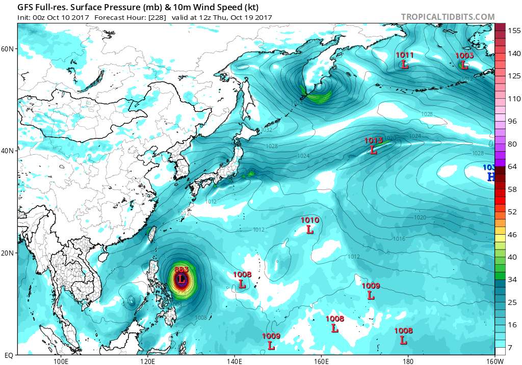
There's already 2 - 98W and there might be another invest in the near future - 99W (could be that area of disorganized convection between Pohnpei/ Kosrae & Marshall islands or maybe something new pops up)
btw, the European model and GFS are now both showing an intensifying system in the Philippine Sea within the next 10 days
10/10 GFS 00z run
btw, the European model and GFS are now both showing an intensifying system in the Philippine Sea within the next 10 days
10/10 GFS 00z run
0 likes
The posts in this forum are NOT official forecast and should not be used as such. They are just the opinion of the poster and may or may not be backed by sound meteorological data. They are NOT endorsed by any professional institution or storm2k.org. For official information, please refer to RSMC, NHC and NWS products.
Who is online
Users browsing this forum: nativefloridian, NotSparta, StPeteMike, TheAustinMan and 235 guests