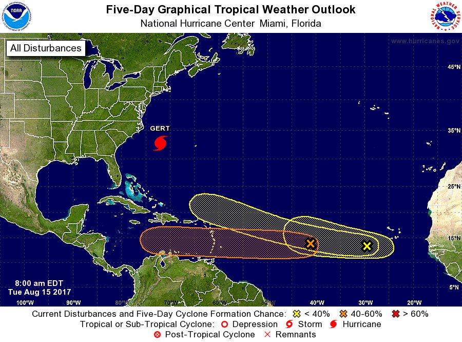
2017 indicators: SST's / MSLP / SAL / Steering / Instability

This is the general tropical discussion area. Anyone can take their shot at predicting a storms path.

Moderator: S2k Moderators

Forum rules

The posts in this forum are NOT official forecasts and should not be used as such. They are just the opinion of the poster and may or may not be backed by sound meteorological data. They are NOT endorsed by any professional institution or STORM2K. For official information, please refer to products from the National Hurricane Center and National Weather Service.

Help Support Storm2K
Message
Author
User avatar
chaser1
S2K Supporter
S2K Supporter
Posts: 4685
Age: 63
Joined: Sat Oct 15, 2005 5:59 pm
Location: Longwood, Fl

Re: 2017 indicators: SST's / MSLP / SAL / Steering / Instability

#1361 Postby chaser1 » Mon Aug 14, 2017 3:25 pm

tarheelprogrammer wrote:
Hammy wrote:
tarheelprogrammer wrote:With systems still struggling to develop in the MDR, and most of the Caribbean outside the area near the Yucatan. It is now common to see them develop in the central Atlantic, or the BOC. Should we consider them the new MDR areas? Seems the Atlantic no matter the pattern likes these areas the most. It has been a while since we seen a true Cape Verde season. Serious question here, and I am not trying to troll. Just want to know if it could change like that. :?:


I pointed this out a few years now, I think because of a few excessively active seasons (in some cases the years that may have sparked interest) the MDR expectations are far too high--it's less common than many thing to see hurricanes and major hurricanes in the deep tropical Atlantic. Look at how seldom Puerto Rico is hit for instance. In fact in the last 22 years, only 6 years--1995, 96, 2000, 03-04, and 2010 were truly MDR-heavy seasons. Even 1999 had the bulk of the strongest activity north of 20, 2005 had only one short-lived hurricane in the MRD, and in 2008 Bertha was at almost 20 before reaching hurricane intensity and Ike was north of there.


Mark Sudduth has pointed out in his videos that the old MDR area near Africa to the Eastern Caribbean is where most storms get going this time of the year. At least in the past they did. However, the past 5 seasons or so that seems to be different. Many here have pointed that out. Odd that the subtopics and BOC seem to be where storms get going. It is puzzling to not only me, but some experts as well.


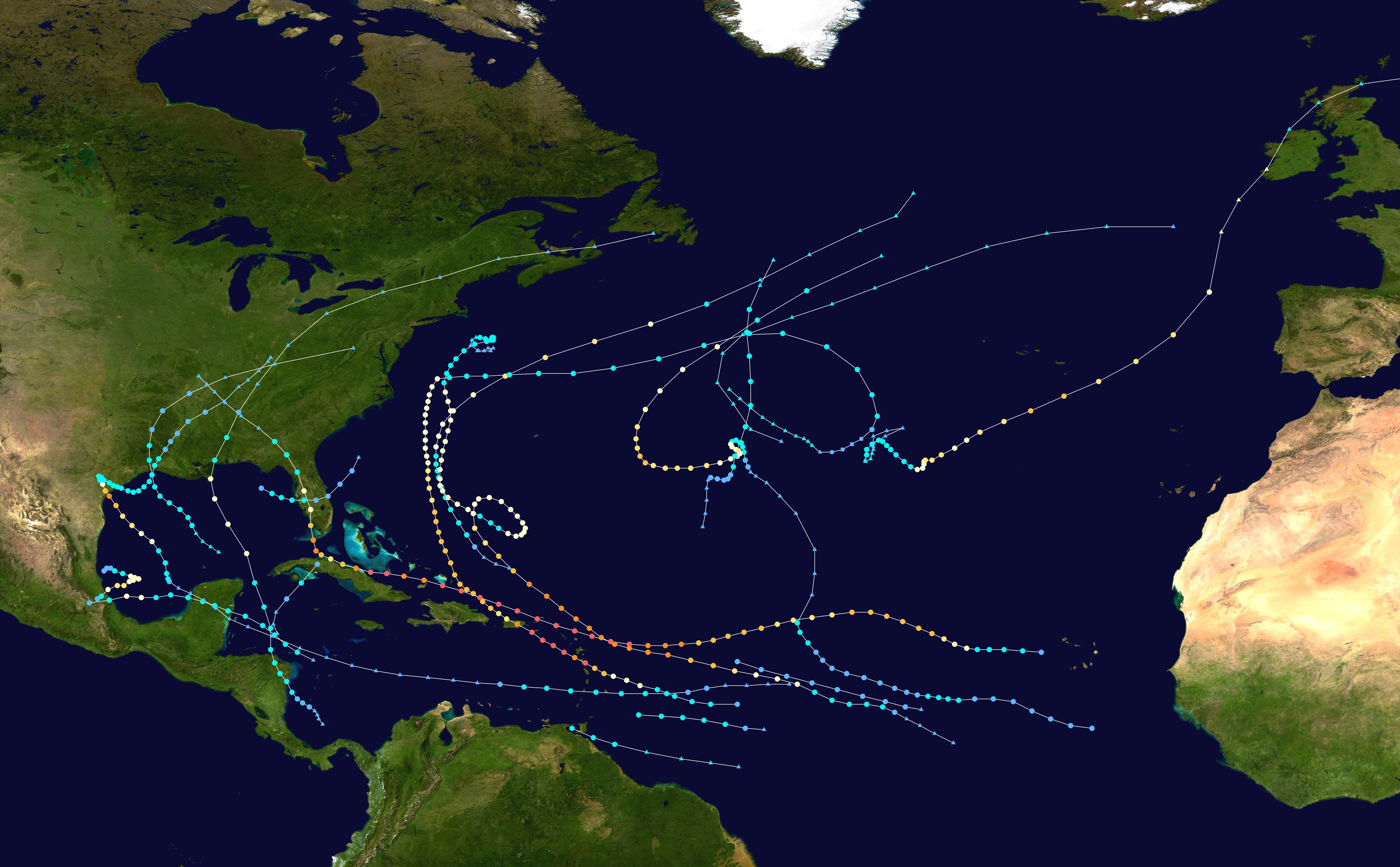
This year up to now (throw in SAL, Climo, etc) https://upload.wikimedia.org/wikipedia/ ... ry_map.png
As for where storms get going "this time of year", are you referring to the last two weeks, the last 2 days, or the next 2 weeks? Genesis cant/wont get going while any small number of variables out of whack. I think that at times some people look at the storms that do develop as "what should happen" and everything else as some nice tidy box and bow solution to think their moment in time will forever reflect in what the future holds. Sometimes it helps to take a few steps back and view the over-all big picture. As tolakram suggested, let the season play out. We might just be 3-8 days away from two MDR developing systems. Even if not, if one were to take a look through the record books it is plain to see how some years had an uncanny concentration of area's of development and where ultimately tracked. Different years often had different tendencies - this is not something new. Lastly, if the good people of San Juan, Miami, or New Orleans get waxed by a mondo Cat 4 Hurricane, do you think their electricity will come on any faster if the hurricane originated in the sub-tropics verses the deeper tropics? This is kind of a pivotable point in the Atlantic season, lets see what plays out for a couple weeks.
1 likes   
Personal Forecast Disclaimer:
The posts in this forum are NOT official forecast and should not be used as such. They are just the opinion of the poster and may or may not be backed by sound meteorological data. They are NOT endorsed by any professional institution or storm2k.org. For official information, please refer to the NHC and NWS products.


RL3AO
Moderator-Pro Met
Moderator-Pro Met
Posts: 16308
Joined: Thu Jun 14, 2007 10:03 pm
Location: NC

Re: 2017 indicators: SST's / MSLP / SAL / Steering / Instability

#1362 Postby RL3AO » Mon Aug 14, 2017 3:29 pm

If Gert does continue to RI, we could be more than double climatology for NS, H, and MH and go above average for ACE by Wednesday. Many on here would probably be surprised by that. :lol:
1 likes   

AxaltaRacing24
Category 5
Category 5
Posts: 1709
Age: 24
Joined: Wed Jul 27, 2016 11:14 am
Location: Jupiter, FL

Re: 2017 indicators: SST's / MSLP / SAL / Steering / Instability

#1363 Postby AxaltaRacing24 » Mon Aug 14, 2017 3:52 pm

RL3AO wrote:If Gert does continue to RI, we could be more than double climatology for NS, H, and MH and go above average for ACE by Wednesday. Many on here would probably be surprised by that. :lol:

Despite the meltdowns in here after a single model run, this season has not been inactive by many means and if we continue at this pace the end numbers should quiet season cancel posts.
2 likes   

tolakram
Admin
Admin
Posts: 19165
Age: 60
Joined: Sun Aug 27, 2006 8:23 pm
Location: Florence, KY (name is Mark)

Re: 2017 indicators: SST's / MSLP / SAL / Steering / Instability

#1364 Postby tolakram » Mon Aug 14, 2017 9:47 pm

Here ya go,

Sun Aug 07, 2005 8:39 pm

viewtopic.php?f=31&t=69988

What a boring year. So the phenomena is not new by any stretch.

I usually dig up one old thread a year so there it is. :lol:
3 likes   
M a r k
- - - - -
Join us in chat: Storm2K Chatroom Invite. Android and IOS apps also available.

The posts in this forum are NOT official forecasts and should not be used as such. Posts are NOT endorsed by any professional institution or STORM2K.org. For official information and forecasts, please refer to NHC and NWS products.

User avatar
Hammy
Category 5
Category 5
Posts: 5594
Age: 40
Joined: Fri May 25, 2012 5:25 pm
Contact:

Re: 2017 indicators: SST's / MSLP / SAL / Steering / Instability

#1365 Postby Hammy » Mon Aug 14, 2017 9:56 pm

tolakram wrote:Here ya go,

Sun Aug 07, 2005 8:39 pm

viewtopic.php?f=31&t=69988

What a boring year. So the phenomena is not new by any stretch.

I usually dig up one old thread a year so there it is. :lol:


Wow. If only people knew...

So after Emily, there really hasn't been anything fun to track. Hopefully late August/early September will change all that
0 likes   
The above post is not official and should not be used as such. It is the opinion of the poster and may or may not be backed by sound meteorological data. It is not endorsed by any professional institution or storm2k.org. For official information, please refer to the NHC and NWS products.

User avatar
TheStormExpert
Category 5
Category 5
Posts: 8487
Age: 30
Joined: Wed Feb 16, 2011 5:38 pm
Location: Palm Beach Gardens, FL

Re: 2017 indicators: SST's / MSLP / SAL / Steering / Instability

#1366 Postby TheStormExpert » Mon Aug 14, 2017 9:57 pm

:uarrow: Now I don't know why people would be calling 2005 a boring season at that point when there was already 9 named storms with 3 (almost 4) of them being hurricanes and 2 of them being majors both affecting land with one U.S. major landfall and a Caribbean Cat.5.
3 likes   
The following post is NOT an official forecast and should not be used as such. It is just the opinion of the poster and may or may not be backed by sound meteorological data. It is NOT endorsed by storm2k.org.

User avatar
Hammy
Category 5
Category 5
Posts: 5594
Age: 40
Joined: Fri May 25, 2012 5:25 pm
Contact:

Re: 2017 indicators: SST's / MSLP / SAL / Steering / Instability

#1367 Postby Hammy » Mon Aug 14, 2017 9:59 pm

TheStormExpert wrote::uarrow: Now I don't know why people would be calling 2005 a boring season at that point when there was already 9 named storms with 3 (almost 4) of them being hurricanes and 2 of them being majors both affecting land with one U.S. major landfall and a Caribbean Cat.5.


It seems like if we don't have a major in the first week of August, regardless of what comes before, people call it a bust. I think 2010 was the first year I really followed S2k (aside from the recon threads) and remember some people in the second week of August were acting like we'd had nothing form yet, despite having a near-Cat 3 in June.
1 likes   
The above post is not official and should not be used as such. It is the opinion of the poster and may or may not be backed by sound meteorological data. It is not endorsed by any professional institution or storm2k.org. For official information, please refer to the NHC and NWS products.

User avatar
Andrew92
S2K Supporter
S2K Supporter
Posts: 3247
Age: 40
Joined: Mon Jun 16, 2003 12:35 am
Location: Phoenix, Arizona

Re: 2017 indicators: SST's / MSLP / SAL / Steering / Instability

#1368 Postby Andrew92 » Mon Aug 14, 2017 10:02 pm

What if it were today's date in either 1961 or 1967? 1961 had just Anna by now, with absolutely nothing again until September. And 1967 had no named storms until the last few days of August!

Season cancel for those two years at this point! Oh wait....

-Andrew92
0 likes   

User avatar
TheStormExpert
Category 5
Category 5
Posts: 8487
Age: 30
Joined: Wed Feb 16, 2011 5:38 pm
Location: Palm Beach Gardens, FL

Re: 2017 indicators: SST's / MSLP / SAL / Steering / Instability

#1369 Postby TheStormExpert » Mon Aug 14, 2017 10:03 pm

Hammy wrote:
tolakram wrote:Here ya go,

Sun Aug 07, 2005 8:39 pm

viewtopic.php?f=31&t=69988

What a boring year. So the phenomena is not new by any stretch.

I usually dig up one old thread a year so there it is. :lol:


Wow. If only people knew...

So after Emily, there really hasn't been anything fun to track. Hopefully late August/early September will change all that

The saying "You better be careful what you wish for" surely applied that year.

I remember Wilma in late October like it was yesterday as I went out into the eye very briefly since it was moving NE at a very good clip and it was overcast and breezy for the most part when the eye passed NE Palm Beach County. Long story short Wilma sure packed a HUGE punch for being a short 4-6 hour duration event here in S. FL.
2 likes   
The following post is NOT an official forecast and should not be used as such. It is just the opinion of the poster and may or may not be backed by sound meteorological data. It is NOT endorsed by storm2k.org.

User avatar
Steve
S2K Supporter
S2K Supporter
Posts: 8607
Joined: Sat Apr 05, 2003 11:41 pm
Location: Not a state-caster

Re: 2017 indicators: SST's / MSLP / SAL / Steering / Instability

#1370 Postby Steve » Mon Aug 14, 2017 10:55 pm

TheStormExpert wrote::uarrow: Now I don't know why people would be calling 2005 a boring season at that point when there was already 9 named storms with 3 (almost 4) of them being hurricanes and 2 of them being majors both affecting land with one U.S. major landfall and a Caribbean Cat.5.


It's almost as if they were looking ahead to 2013. ;)
---------------------------------------
FWIW for indicators, next wave behind 91L should develop. Low pressure embedded within the overall flow drops down from 40N/30W and merges with the other upper low and should precede 92L (if that's what it's name is going to be) similarly to the dry low in front of 91L. You can see it on the MIMIC.
http://tropic.ssec.wisc.edu/real-time/m ... /main.html
1 likes   

User avatar
chaser1
S2K Supporter
S2K Supporter
Posts: 4685
Age: 63
Joined: Sat Oct 15, 2005 5:59 pm
Location: Longwood, Fl

Re: 2017 indicators: SST's / MSLP / SAL / Steering / Instability

#1371 Postby chaser1 » Tue Aug 15, 2017 3:01 am

tolakram wrote:Here ya go,

Sun Aug 07, 2005 8:39 pm

viewtopic.php?f=31&t=69988

What a boring year. So the phenomena is not new by any stretch.

I usually dig up one old thread a year so there it is. :lol:


Ah... the best of time, and the worst of times. That link was somehow both entertaining as well as nauseating to read all at the same time LOL.
0 likes   
Personal Forecast Disclaimer:
The posts in this forum are NOT official forecast and should not be used as such. They are just the opinion of the poster and may or may not be backed by sound meteorological data. They are NOT endorsed by any professional institution or storm2k.org. For official information, please refer to the NHC and NWS products.


User avatar
Hammy
Category 5
Category 5
Posts: 5594
Age: 40
Joined: Fri May 25, 2012 5:25 pm
Contact:

Re: 2017 indicators: SST's / MSLP / SAL / Steering / Instability

#1372 Postby Hammy » Tue Aug 15, 2017 3:17 am

chaser1 wrote:
tolakram wrote:Here ya go,

Sun Aug 07, 2005 8:39 pm

viewtopic.php?f=31&t=69988

What a boring year. So the phenomena is not new by any stretch.

I usually dig up one old thread a year so there it is. :lol:


Ah... the best of time, and the worst of times. That link was somehow both entertaining as well as nauseating to read all at the same time LOL.


Another I found a bit amusing as a satirical thread turned serious, from 2010. http://www.storm2k.org/phpbb2/viewtopic.php?f=31&t=108099&start=160

As an aside (aside from the few "season cancel" titled ones I found) how do you go about find these threads? It'd be interesting to go back and re-read them--this one being the first one I remember.
0 likes   
The above post is not official and should not be used as such. It is the opinion of the poster and may or may not be backed by sound meteorological data. It is not endorsed by any professional institution or storm2k.org. For official information, please refer to the NHC and NWS products.

tolakram
Admin
Admin
Posts: 19165
Age: 60
Joined: Sun Aug 27, 2006 8:23 pm
Location: Florence, KY (name is Mark)

Re: 2017 indicators: SST's / MSLP / SAL / Steering / Instability

#1373 Postby tolakram » Tue Aug 15, 2017 6:47 am

Go to Talking Tropics, go back a page, then look at the URL which will look like this:

http://www.storm2k.org/phpbb2/viewforum.php?f=31&start=50

Change the start number ... 2005 is around 13000. Please do NOT reply to any of those old posts.

On a serious note ... as far as activity is concerned and in my opinion. I know many of you don't mean it, or maybe some do , but complaining about a boring season when we have active storms is kind of a giveaway that 'not boring' means someone is going to get hit by a storm. We play this little dance with the season cancel posts every year, and sometimes the season is a dud, but sometimes it's the track of the storms that bores people. Think before you post, and if you're posting because your mad a storm that was modeled to hit the US is not happening then take a breather. Hurricane season is not a game.

I have fun tracking hurricanes, I have fun watching them develop, especially with the new GOES 16 imagery. It's certainly more exciting and dreadful when a storm is heading toward land, but a season of recurving storms, or storms that don't hit the US, or the continuation of 'no majors' hitting the US does not indicate the season is boring or the world / oceans / Atlantic has somehow permanently changed.

Let the season continue, post if you see pattern changes that you think warrant discussion (with evidence), and let's review once the season is nearing an end.
0 likes   
M a r k
- - - - -
Join us in chat: Storm2K Chatroom Invite. Android and IOS apps also available.

The posts in this forum are NOT official forecasts and should not be used as such. Posts are NOT endorsed by any professional institution or STORM2K.org. For official information and forecasts, please refer to NHC and NWS products.

User avatar
cycloneye
Admin
Admin
Posts: 139174
Age: 67
Joined: Thu Oct 10, 2002 10:54 am
Location: San Juan, Puerto Rico

Re: 2017 indicators: SST's / MSLP / SAL / Steering / Instability

#1374 Postby cycloneye » Tue Aug 15, 2017 7:31 am

Those who like to track systems are happy to see activity picking up.7/2/0 by August 15 is a good set for a season but I know ACE is below average however things will pick up in the next few weeks to get to normal ACE.

Image
0 likes   
Visit the Caribbean-Central America Weather Thread where you can find at first post web cams,radars
and observations from Caribbean basin members Click Here

User avatar
SFLcane
S2K Supporter
S2K Supporter
Posts: 9614
Age: 46
Joined: Sat Jun 05, 2010 1:44 pm
Location: Lake Worth Florida

Re: 2017 indicators: SST's / MSLP / SAL / Steering / Instability

#1375 Postby SFLcane » Tue Aug 15, 2017 8:27 am

Record warm sst's across the main development region this year but other factors are unfavorable. Stable air mass being one.
0 likes   

User avatar
SFLcane
S2K Supporter
S2K Supporter
Posts: 9614
Age: 46
Joined: Sat Jun 05, 2010 1:44 pm
Location: Lake Worth Florida

Re: 2017 indicators: SST's / MSLP / SAL / Steering / Instability

#1376 Postby SFLcane » Tue Aug 15, 2017 8:50 am

1 likes   

RL3AO
Moderator-Pro Met
Moderator-Pro Met
Posts: 16308
Joined: Thu Jun 14, 2007 10:03 pm
Location: NC

Re: 2017 indicators: SST's / MSLP / SAL / Steering / Instability

#1377 Postby RL3AO » Tue Aug 15, 2017 9:54 am

Quietest worst bustiest and most disappointing season ever. There's absolutely nothing going on. Quiet as a feather. Nothing too look at. We probably won't even hit the E storm this year. Or something.

Image
2 likes   

User avatar
tarheelprogrammer
S2K Supporter
S2K Supporter
Posts: 1793
Joined: Mon Mar 28, 2016 9:25 pm
Location: Raleigh, NC area (Garner, NC)

Re: 2017 indicators: SST's / MSLP / SAL / Steering / Instability

#1378 Postby tarheelprogrammer » Tue Aug 15, 2017 10:32 am

What is creating the huge SAL outbreaks?
0 likes   
My posts are not official forecasts. They are just my opinion and may or may not be backed by sound meteorological data. They are NOT endorsed by any professional institution or storm2k.org. For official information, please refer to the NHC and NWS products.

User avatar
GCANE
S2K Supporter
S2K Supporter
Posts: 10787
Joined: Mon Oct 22, 2007 8:03 am

Re: 2017 indicators: SST's / MSLP / SAL / Steering / Instability

#1379 Postby GCANE » Tue Aug 15, 2017 11:41 am

The forecast surface highs in the Atlantic starting to weaken over the next few weeks.
Stronger highs positioned well in the NE section near Europe.
And, EPAC TC development is also forecast to slack off.
UL condtions improving quickly for the Atlantic MDR due to a breakdown of UL Hadley-Cell winds.
Looks to be very busy in the Atlantic for the foreseeable future.
0 likes   

Alyono
Professional-Met
Professional-Met
Posts: 6961
Joined: Fri Apr 26, 2013 3:52 pm
Location: Texas Coast

Re: 2017 indicators: SST's / MSLP / SAL / Steering / Instability

#1380 Postby Alyono » Tue Aug 15, 2017 1:41 pm

pattern looks unfavorable for US mainland strikes at this time. Looks to be 2 possible paths. One is the out to sea Gert path. The other is a path into Central America. Looks like a weakness over the western Atlantic and then very strong ridging over the Gulf coast
1 likes   


Return to “Talkin' Tropics”

Who is online

Users browsing this forum: cainjamin, Google Adsense [Bot] and 224 guests