
2017 indicators: SST's / MSLP / SAL / Steering / Instability
Moderator: S2k Moderators
Forum rules

The posts in this forum are NOT official forecasts and should not be used as such. They are just the opinion of the poster and may or may not be backed by sound meteorological data. They are NOT endorsed by any professional institution or STORM2K. For official information, please refer to products from the National Hurricane Center and National Weather Service.
Re: 2017 indicators: SST's / MSLP / SAL / Steering / Instability
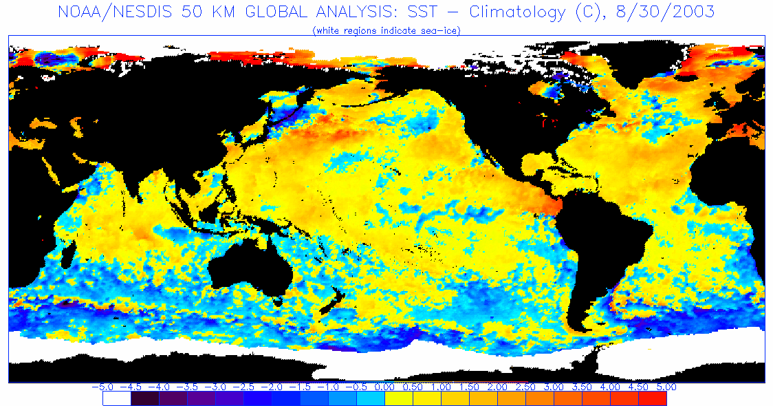
If I remember correctly, the unfavorable subtropical configuration that was mentioned some time ago as unfavorable was having subtropical waters significantly warmer than the tropical Atlantic. The above map doesn't look like an unfavorable SST setup, and in fact resembles 2003, so there's likely something else going on.
0 likes
The above post is not official and should not be used as such. It is the opinion of the poster and may or may not be backed by sound meteorological data. It is not endorsed by any professional institution or storm2k.org. For official information, please refer to the NHC and NWS products.


Re: 2017 indicators: SST's / MSLP / SAL / Steering / Instability
The water off Columbia was insane that year, but otherwise that's not that bad of an analog for early August at all. 2003 was kind of sick. All we saw was Bill early, but it rained that spring like it has been raining insanely all late July and August here. ?
Didn't 2003 turn out to be kind of a semi extreme year? I think it was Fabian (?) that maybe gave that ACE boost, (edit, it turned into a 16-7-3 175 ACE year. I could see the numbers but not the ACE.)
Didn't 2003 turn out to be kind of a semi extreme year? I think it was Fabian (?) that maybe gave that ACE boost, (edit, it turned into a 16-7-3 175 ACE year. I could see the numbers but not the ACE.)
0 likes
-
TheStormExpert

- Category 5

- Posts: 8487
- Age: 30
- Joined: Wed Feb 16, 2011 5:38 pm
- Location: Palm Beach Gardens, FL
Re: 2017 indicators: SST's / MSLP / SAL / Steering / Instability
Steve wrote:TheStormExpert wrote:RL3AO wrote:
Who are the "many" predicting a hyperactive season?
I guess I made a typo.
But surely NOAA's prediction of an potential hyperactive season will likely bust with the latest SST configuration. Luckily for them they have a wide range of outcomes on the table with numbers as low as a near average season.
So what do you think happens?
An average to slightly above average season in terms of named storms. Hurricanes and majors might run lower.
2 likes
The following post is NOT an official forecast and should not be used as such. It is just the opinion of the poster and may or may not be backed by sound meteorological data. It is NOT endorsed by storm2k.org.
Re: 2017 indicators: SST's / MSLP / SAL / Steering / Instability
Steve wrote:The water off Columbia was insane that year, but otherwise that's not that bad of an analog for early August at all. 2003 was kind of sick. All we saw was Bill early, but it rained that spring like it has been raining insanely all late July and August here. ?
Didn't 2003 turn out to be kind of a semi extreme year? I think it was Fabian (?) that maybe gave that ACE boost, (edit, it turned into a 16-7-3 175 ACE year. I could see the numbers but not the ACE.)
2003 was basically Fabian, Isabel, and Kate (which lasted an absurdly long time) and the rest were relatively short-lived for the most part. Interestingly now that I mention the year as a comparison, it's also the only other time we've had a tropical storm in April, and featured an MDR storm in June (though a depression). August was also entirely void of MDR activity (Caribbean included) except for Fabian in late August. The key difference so far seems to be that July was more favorable.
1 likes
The above post is not official and should not be used as such. It is the opinion of the poster and may or may not be backed by sound meteorological data. It is not endorsed by any professional institution or storm2k.org. For official information, please refer to the NHC and NWS products.
Re: 2017 indicators: SST's / MSLP / SAL / Steering / Instability
TheStormExpert wrote:Steve wrote:TheStormExpert wrote:I guess I made a typo.
But surely NOAA's prediction of an potential hyperactive season will likely bust with the latest SST configuration. Luckily for them they have a wide range of outcomes on the table with numbers as low as a near average season.
So what do you think happens?
An average to slightly above average season in terms of named storms. Hurricanes and majors might run lower.
I think I'm right there with you.
0 likes

Re: 2017 indicators: SST's / MSLP / SAL / Steering / Instability
Since when h85 was considered mid levels?
H70 paints a different picture for the same time period.
1 likes
Re: 2017 indicators: SST's / MSLP / SAL / Steering / Instability
Steve wrote:TheStormExpert wrote:Steve wrote:
So what do you think happens?
An average to slightly above average season in terms of named storms. Hurricanes and majors might run lower.
I think I'm right there with you.
Only August 17th and already calling for just an average season just because some dry/stable air in the middle of the Atlantic that the TWs have to deal with? If this was in the middle of September I would have probably agreed with you, but even then.
1 likes
Re: 2017 indicators: SST's / MSLP / SAL / Steering / Instability
NDG wrote:Steve wrote:TheStormExpert wrote:An average to slightly above average season in terms of named storms. Hurricanes and majors might run lower.
I think I'm right there with you.
Only August 17th and already calling for just an average season just because some dry/stable air in the middle of the Atlantic that the TWs have to deal with? If this was in the middle of September I would have probably agreed with you, but even then.
7-2-0. We were agreeing more named storms than average and probably H/IH near or slightly below normal. I always thought ACE would be a bit over 100. I fully acknowledge that I could be dead wrong and will happily admit it when I am
0 likes
-
weathaguyry

- Category 5
- Posts: 1272
- Age: 20
- Joined: Wed Jun 15, 2016 5:16 am
- Location: Long Island, NY
Re: 2017 indicators: SST's / MSLP / SAL / Steering / Instability
Steve wrote:NDG wrote:Steve wrote:
I think I'm right there with you.
Only August 17th and already calling for just an average season just because some dry/stable air in the middle of the Atlantic that the TWs have to deal with? If this was in the middle of September I would have probably agreed with you, but even then.
7-2-0. We were agreeing more named storms than average and probably H/IH near or slightly below normal. I always thought ACE would be a bit over 100. I fully acknowledge that I could be dead wrong and will happily admit it when I am
I definitely feel a 2012 ish kind of vibe with this season, with more quantity over quality storms.
0 likes
My posts are only my opinions and NOT official forecasts. For official forecasts, consult the National Hurricane Center or the National Weather Service.
Irene 11', Sandy 12', Fay 20’, Isaias 20’, Elsa 21’, Henri 21’, Ida 21’
Irene 11', Sandy 12', Fay 20’, Isaias 20’, Elsa 21’, Henri 21’, Ida 21’
Re: 2017 indicators: SST's / MSLP / SAL / Steering / Instability
weathaguyry wrote:Steve wrote:NDG wrote:
Only August 17th and already calling for just an average season just because some dry/stable air in the middle of the Atlantic that the TWs have to deal with? If this was in the middle of September I would have probably agreed with you, but even then.
7-2-0. We were agreeing more named storms than average and probably H/IH near or slightly below normal. I always thought ACE would be a bit over 100. I fully acknowledge that I could be dead wrong and will happily admit it when I am
I definitely feel a 2012 ish kind of vibe with this season, with more quantity over quality storms.
Name me a system that has had problems with dry air in the western Atlantic Basin this year (expect for Cindy) like they did in 2012 & 2013 during the heart of the hurricane season.
0 likes
-
tolakram
- Admin

- Posts: 19165
- Age: 60
- Joined: Sun Aug 27, 2006 8:23 pm
- Location: Florence, KY (name is Mark)
Re: 2017 indicators: SST's / MSLP / SAL / Steering / Instability
NDG wrote:
Name me a system that has had problems with dry air in the western Atlantic Basin this year (expect for Cindy) like they did in 2012 & 2013 during the heart of the hurricane season.
Let's answer this when we get through the heart of the hurricane season, no use arguing now. I certainly agree that the western part of the basin looks decent for development.
It's August 17th.
1 likes
M a r k
- - - - -
Join us in chat: Storm2K Chatroom Invite. Android and IOS apps also available.
The posts in this forum are NOT official forecasts and should not be used as such. Posts are NOT endorsed by any professional institution or STORM2K.org. For official information and forecasts, please refer to NHC and NWS products.

Re: 2017 indicators: SST's / MSLP / SAL / Steering / Instability
The Atlantic is behaving so far about what it should be. ACE is near normal, plenty of names, a couple of decent hurricanes. ACE averages rise at a faster pace the next 60 days so as long as a few more hurricanes form. In a normal Atlantic season often most of the ACE is collected by 1-2 majors, all doable. 1983, 2013 and 2004, 2005 comparisons likely are not high odds on the table at this point.
1 likes
The above post and any post by Ntxw is NOT an official forecast and should not be used as such. It is just the opinion of the poster and may or may not be backed by sound meteorological data. It is NOT endorsed by any professional institution including Storm2k. For official information, please refer to NWS products.
Help support Storm2K!
Re: 2017 indicators: SST's / MSLP / SAL / Steering / Instability
Ntxw wrote:The Atlantic is behaving so far about what it should be. ACE is near normal, plenty of names, a couple of decent hurricanes. ACE averages rise at a faster pace the next 60 days so as long as a few more hurricanes form. In a normal Atlantic season often most of the ACE is collected by 1-2 majors, all doable. 1983, 2013 and 2004, 2005 comparisons likely are not high odds on the table at this point.
I've said the same thing about 83, 13, 04 and 05. The one I'm least likely to discount is 2004 due to some of the continental similarities. So it's possible we may see a similar western based collection of tracks. I don't think we get anywhere near 6 majors though. Again, if I'm wrong, I'd be happy to admit it.
1 likes
Re: 2017 indicators: SST's / MSLP / SAL / Steering / Instability
Steve wrote:Ntxw wrote:The Atlantic is behaving so far about what it should be. ACE is near normal, plenty of names, a couple of decent hurricanes. ACE averages rise at a faster pace the next 60 days so as long as a few more hurricanes form. In a normal Atlantic season often most of the ACE is collected by 1-2 majors, all doable. 1983, 2013 and 2004, 2005 comparisons likely are not high odds on the table at this point.
I've said the same thing about 83, 13, 04 and 05. The one I'm least likely to discount is 2004 due to some of the continental similarities. So it's possible we may see a similar western based collection of tracks. I don't think we get anywhere near 6 majors though. Again, if I'm wrong, I'd be happy to admit it.
I think 2005 would be a good analog as far as being west based--Philippe was the only named system in the MDR the entire season after July's absurd level of activity for example--but with probably 2001 or 03 type activity.
1 likes
The above post is not official and should not be used as such. It is the opinion of the poster and may or may not be backed by sound meteorological data. It is not endorsed by any professional institution or storm2k.org. For official information, please refer to the NHC and NWS products.
Re: 2017 indicators: SST's / MSLP / SAL / Steering / Instability
Hammy wrote:Steve wrote:Ntxw wrote:The Atlantic is behaving so far about what it should be. ACE is near normal, plenty of names, a couple of decent hurricanes. ACE averages rise at a faster pace the next 60 days so as long as a few more hurricanes form. In a normal Atlantic season often most of the ACE is collected by 1-2 majors, all doable. 1983, 2013 and 2004, 2005 comparisons likely are not high odds on the table at this point.
I've said the same thing about 83, 13, 04 and 05. The one I'm least likely to discount is 2004 due to some of the continental similarities. So it's possible we may see a similar western based collection of tracks. I don't think we get anywhere near 6 majors though. Again, if I'm wrong, I'd be happy to admit it.
I think 2005 would be a good analog as far as being west based--Philippe was the only named system in the MDR the entire season after July's absurd level of activity for example--but with probably 2001 or 03 type activity.
So you are thinking we end up a bit above average on numbers and maybe +20/+30 ACE?
0 likes
Re: 2017 indicators: SST's / MSLP / SAL / Steering / Instability
Steve wrote:Hammy wrote:Steve wrote:
I've said the same thing about 83, 13, 04 and 05. The one I'm least likely to discount is 2004 due to some of the continental similarities. So it's possible we may see a similar western based collection of tracks. I don't think we get anywhere near 6 majors though. Again, if I'm wrong, I'd be happy to admit it.
I think 2005 would be a good analog as far as being west based--Philippe was the only named system in the MDR the entire season after July's absurd level of activity for example--but with probably 2001 or 03 type activity.
So you are thinking we end up a bit above average on numbers and maybe +20/+30 ACE?
Probably within the "near normal" range, but probably slightly above the median average, and almost certainly above average named storms since we're already close to H and we're still over three weeks away from the peak. Probably 14-16 storms unless something dramatic changes, but I'm not confident enough given the conditions to predict how many hurricanes or majors we'll see.
1 likes
The above post is not official and should not be used as such. It is the opinion of the poster and may or may not be backed by sound meteorological data. It is not endorsed by any professional institution or storm2k.org. For official information, please refer to the NHC and NWS products.
Re: 2017 indicators: SST's / MSLP / SAL / Steering / Instability
Same here which is why I am tending to be lower on potential numbers of H & IH than what may actually happen. That's based on the idea of many systems developing west of 65 and running out of room to get super strong (in the means, not necessarily individually).
0 likes

Re: 2017 indicators: SST's / MSLP / SAL / Steering / Instability
if we only get a short lived TS out of all the tropical Atlantic activity like the EC is saying, then the 2013 parallel is something worth considering more strongly
2 likes
Re: 2017 indicators: SST's / MSLP / SAL / Steering / Instability
Alyono wrote:if we only get a short lived TS out of all the tropical Atlantic activity like the EC is saying, then the 2013 parallel is something worth considering more strongly
I know the thermohaline circulation was a major contributor to 2013, is there any way to check that in realtime as with other factors?
1 likes
The above post is not official and should not be used as such. It is the opinion of the poster and may or may not be backed by sound meteorological data. It is not endorsed by any professional institution or storm2k.org. For official information, please refer to the NHC and NWS products.
Re: 2017 indicators: SST's / MSLP / SAL / Steering / Instability
Hammy wrote:Alyono wrote:if we only get a short lived TS out of all the tropical Atlantic activity like the EC is saying, then the 2013 parallel is something worth considering more strongly
I know the thermohaline circulation was a major contributor to 2013, is there any way to check that in realtime as with other factors?
beyond my level of expertise
1 likes
Who is online
Users browsing this forum: Google Adsense [Bot], KirbyDude25, wxman57 and 204 guests