2017 indicators: SST's / MSLP / SAL / Steering / Instability
Moderator: S2k Moderators
Forum rules

The posts in this forum are NOT official forecasts and should not be used as such. They are just the opinion of the poster and may or may not be backed by sound meteorological data. They are NOT endorsed by any professional institution or STORM2K. For official information, please refer to products from the National Hurricane Center and National Weather Service.
-
TheStormExpert

- Category 5

- Posts: 8487
- Age: 30
- Joined: Wed Feb 16, 2011 5:38 pm
- Location: Palm Beach Gardens, FL
Re: 2017 indicators: SST's / MSLP / SAL / Steering / Instability
1 likes
The following post is NOT an official forecast and should not be used as such. It is just the opinion of the poster and may or may not be backed by sound meteorological data. It is NOT endorsed by storm2k.org.
-
weathaguyry

- Category 5
- Posts: 1272
- Age: 20
- Joined: Wed Jun 15, 2016 5:16 am
- Location: Long Island, NY
Re: 2017 indicators: SST's / MSLP / SAL / Steering / Instability
TheStormExpert wrote::uarrow: Doesn't look very El Niño-ish if you ask me.
Agreed, also, I've heard a lot of people talk about the PDO being very positive, but isn't it nowhere near as positive as it was at the start of last season?
0 likes
My posts are only my opinions and NOT official forecasts. For official forecasts, consult the National Hurricane Center or the National Weather Service.
Irene 11', Sandy 12', Fay 20’, Isaias 20’, Elsa 21’, Henri 21’, Ida 21’
Irene 11', Sandy 12', Fay 20’, Isaias 20’, Elsa 21’, Henri 21’, Ida 21’
-
Kingarabian

- S2K Supporter

- Posts: 15437
- Joined: Sat Aug 08, 2009 3:06 am
- Location: Honolulu, Hawaii
Re: 2017 indicators: SST's / MSLP / SAL / Steering / Instability
2017 is the year that I hope brings changes to the CFS. It basically calls for an El Nino every year.
0 likes
RIP Kobe Bryant
-
Hurricaneman

- Category 5
- Posts: 7282
- Age: 43
- Joined: Tue Aug 31, 2004 3:24 pm
- Location: central florida
Re: 2017 indicators: SST's / MSLP / SAL / Steering / Instability
Looks like a positive Atlantic tripole seems to be trying to establish itself, we have to see if the MDR can warm a little bit more but that's my impression on this
1 likes
-
tarheelprogrammer

- S2K Supporter
- Posts: 1793
- Joined: Mon Mar 28, 2016 9:25 pm
- Location: Raleigh, NC area (Garner, NC)
Re: 2017 indicators: SST's / MSLP / SAL / Steering / Instability
Hurricaneman wrote:Looks like a positive Atlantic tripole seems to be trying to establish itself, we have to see if the MDR can warm a little bit more but that's my impression on this
What would this mean for the Atlantic season if that is the case?
0 likes
My posts are not official forecasts. They are just my opinion and may or may not be backed by sound meteorological data. They are NOT endorsed by any professional institution or storm2k.org. For official information, please refer to the NHC and NWS products.
-
Hurricaneman
- Category 5
- Posts: 7282
- Age: 43
- Joined: Tue Aug 31, 2004 3:24 pm
- Location: central florida
Re: 2017 indicators: SST's / MSLP / SAL / Steering / Instability
tarheelprogrammer wrote:Hurricaneman wrote:Looks like a positive Atlantic tripole seems to be trying to establish itself, we have to see if the MDR can warm a little bit more but that's my impression on this
What would this mean for the Atlantic season if that is the case?
Usually means a more favorable environment for tropical systems to develop in the MDR
0 likes
-
AutoPenalti
- Category 5
- Posts: 3949
- Age: 27
- Joined: Mon Aug 17, 2015 4:16 pm
- Location: Ft. Lauderdale, Florida
Re: 2017 indicators: SST's / MSLP / SAL / Steering / Instability
I honestly wanted to rule out 2005 as an analog for this season, since it was such a hyper-active season, but considering the latest developments and the warming of the MDR and what seems to be like a positive tripole trying to develop, I can't help but say that it's something that cannot be ruled out. I'm not saying we may see something as active as last decade, however we may see something close to an active season compared to prior years. Quite interesting to say the least.
0 likes
The posts in this forum are NOT official forecasts and should not be used as such. They are just the opinion of the poster and may or may not be backed by sound meteorological data. They are NOT endorsed by any professional institution or STORM2K. For official information, please refer to products from the NHC and NWS.
Model Runs Cheat Sheet:
GFS (5:30 AM/PM, 11:30 AM/PM)
HWRF, GFDL, UKMET, NAVGEM (6:30-8:00 AM/PM, 12:30-2:00 AM/PM)
ECMWF (1:45 AM/PM)
TCVN is a weighted averaged

Re: 2017 indicators: SST's / MSLP / SAL / Steering / Instability
AutoPenalti wrote:I honestly wanted to rule out 2005 as an analog for this season, since it was such a hyper-active season, but considering the latest developments and the warming of the MDR and what seems to be like a positive tripole trying to develop, I can't help but say that it's something that cannot be ruled out. I'm not saying we may see something as active as last decade, however we may see something close to an active season compared to prior years. Quite interesting to say the least.
I think track-wise 2005 would actually be a good year to use, as the Gulf and Caribbean, as well as the subtropical Atlantic, were quite active, while the MDR was largely dead--that being said I don't see the number of intensity of storms from that year being repeated.
1 likes
The above post is not official and should not be used as such. It is the opinion of the poster and may or may not be backed by sound meteorological data. It is not endorsed by any professional institution or storm2k.org. For official information, please refer to the NHC and NWS products.
-
WeatherEmperor
- S2K Supporter
- Posts: 4806
- Age: 40
- Joined: Thu Sep 04, 2003 2:54 pm
- Location: South Florida
Re: 2017 indicators: SST's / MSLP / SAL / Steering / Instability
I see you guys mentioning 2005 as a possible analog and also the warming of the MDR waters. What does this mean in terms of the Euro still forecasting above normal pressures for the MDR? Could the Euro back off on this in future runs??
Sent from my iPhone 7 using Tapatalk
Sent from my iPhone 7 using Tapatalk
0 likes
-
TheStormExpert
- Category 5
- Posts: 8487
- Age: 30
- Joined: Wed Feb 16, 2011 5:38 pm
- Location: Palm Beach Gardens, FL
Re: 2017 indicators: SST's / MSLP / SAL / Steering / Instability
I agree with Hammy that 2005 could only be an analog track-wise. In no way is it an analog numbers-wise.
In fact just listening to many on here go on about how the Atlantic should actually be less favorable overall when compared to last season, and the East/Central Pacific should be much more favorable than what it was last season I'd go with the majority of storms that do affect land(including the U.S.) being on the weaker side of things.
I still think once again Colorado State is being too low with their numbers. 14/6/3 seems reasonable for now.
1 likes
The following post is NOT an official forecast and should not be used as such. It is just the opinion of the poster and may or may not be backed by sound meteorological data. It is NOT endorsed by storm2k.org.

Re: 2017 indicators: SST's / MSLP / SAL / Steering / Instability
CSU has been on the lower end of the spectrum past few years. Conditions are not that bad, or doesn't seem like it at this point. But there is no big signal for a huge season either. 2005, like 1983 on the other end of the spectrum, are extreme seasons. They are once a lifetime kind of seasons and are rare. Had the past 3-4 seasons been hyperactive the argument could be made for comparison. A near normal season, perhaps more emphasis on quantity but a lot of mixed signals. We should have a better idea next month.
0 likes
The above post and any post by Ntxw is NOT an official forecast and should not be used as such. It is just the opinion of the poster and may or may not be backed by sound meteorological data. It is NOT endorsed by any professional institution including Storm2k. For official information, please refer to NWS products.
Help support Storm2K!
-
Kazmit

- Category 5
- Posts: 1915
- Age: 21
- Joined: Mon Jul 25, 2016 8:49 am
- Location: Williamsburg VA for college, Bermuda otherwise
Re: 2017 indicators: SST's / MSLP / SAL / Steering / Instability
Numbers-wise, I think we'll see something similar to last year, although probably no more than that. And yes, as others are saying, I think there will be more land impacts this year, at least for most of the season. A lot depends on whether or not El Niño develops, but I personally doubt it.
1 likes
Igor 2010, Sandy 2012, Fay 2014, Gonzalo 2014, Joaquin 2015, Nicole 2016, Humberto 2019
I am only a tropical weather enthusiast. My predictions are not official and may or may not be backed by sound meteorological data. For official information, please refer to the NHC and NWS products.
I am only a tropical weather enthusiast. My predictions are not official and may or may not be backed by sound meteorological data. For official information, please refer to the NHC and NWS products.

Re: 2017 indicators: SST's / MSLP / SAL / Steering / Instability
Ntxw wrote:CSU has been on the lower end of the spectrum past few years. Conditions are not that bad, or doesn't seem like it at this point. But there is no big signal for a huge season either. 2005, like 1983 on the other end of the spectrum, are extreme seasons. They are once a lifetime kind of seasons and are rare. Had the past 3-4 seasons been hyperactive the argument could be made for comparison. A near normal season, perhaps more emphasis on quantity but a lot of mixed signals. We should have a better idea next month.
Just a note that 2005 was initially forecast to be an average season of 15/8/4
1 likes

Re: 2017 indicators: SST's / MSLP / SAL / Steering / Instability
Alyono wrote:Ntxw wrote:CSU has been on the lower end of the spectrum past few years. Conditions are not that bad, or doesn't seem like it at this point. But there is no big signal for a huge season either. 2005, like 1983 on the other end of the spectrum, are extreme seasons. They are once a lifetime kind of seasons and are rare. Had the past 3-4 seasons been hyperactive the argument could be made for comparison. A near normal season, perhaps more emphasis on quantity but a lot of mixed signals. We should have a better idea next month.
Just a note that 2005 was initially forecast to be an average season of 15/8/4
I certainly don't remember but do you recall "when" and "what" conditions evolved that year where everyone began taking greater notice that the season might evolve the way it did? I'm curious what particular signals did that years' global long range models essentially "bust on" or simply not anticipate?
Now that I"m thinking about it, I wonder which pre-season forecast prognostications were the most bullish about that upcoming season.
0 likes
Personal Forecast Disclaimer:
The posts in this forum are NOT official forecast and should not be used as such. They are just the opinion of the poster and may or may not be backed by sound meteorological data. They are NOT endorsed by any professional institution or storm2k.org. For official information, please refer to the NHC and NWS products.
The posts in this forum are NOT official forecast and should not be used as such. They are just the opinion of the poster and may or may not be backed by sound meteorological data. They are NOT endorsed by any professional institution or storm2k.org. For official information, please refer to the NHC and NWS products.
Re: 2017 indicators: SST's / MSLP / SAL / Steering / Instability
chaser1 wrote:Alyono wrote:Ntxw wrote:CSU has been on the lower end of the spectrum past few years. Conditions are not that bad, or doesn't seem like it at this point. But there is no big signal for a huge season either. 2005, like 1983 on the other end of the spectrum, are extreme seasons. They are once a lifetime kind of seasons and are rare. Had the past 3-4 seasons been hyperactive the argument could be made for comparison. A near normal season, perhaps more emphasis on quantity but a lot of mixed signals. We should have a better idea next month.
Just a note that 2005 was initially forecast to be an average season of 15/8/4
I certainly don't remember but do you recall "when" and "what" conditions evolved that year where everyone began taking greater notice that the season might evolve the way it did? I'm curious what particular signals did that years' global long range models essentially "bust on" or simply not anticipate?
Now that I"m thinking about it, I wonder which pre-season forecast prognostications were the most bullish about that upcoming season.
the first 2005 hyperactive forecast was the August one, after we were already at 7/3/2
1 likes
-
WeatherEmperor
- S2K Supporter
- Posts: 4806
- Age: 40
- Joined: Thu Sep 04, 2003 2:54 pm
- Location: South Florida
Re: 2017 indicators: SST's / MSLP / SAL / Steering / Instability
Over in the ENSO thread they just posted that a significant WWB is about to take place which could kick start this El Nino. I dont think number wise we should be using 2005 as an analog if the Nini gets going but maybe trackwise its ok?
Sent from my iPhone 7 using Tapatalk
Sent from my iPhone 7 using Tapatalk
0 likes

Re: 2017 indicators: SST's / MSLP / SAL / Steering / Instability
WeatherEmperor wrote:I see you guys mentioning 2005 as a possible analog and also the warming of the MDR waters. What does this mean in terms of the Euro still forecasting above normal pressures for the MDR? Could the Euro back off on this in future runs??
Sent from my iPhone 7 using Tapatalk
Just about every year during the past 5-6 years the Euro has biased on the high side when it comes to pressures over the Atlantic basin.
1 likes
-
weathaguyry
- Category 5
- Posts: 1272
- Age: 20
- Joined: Wed Jun 15, 2016 5:16 am
- Location: Long Island, NY
Re: 2017 indicators: SST's / MSLP / SAL / Steering / Instability
Quite a bit of warming in the MDR, looking nice!
0 likes
My posts are only my opinions and NOT official forecasts. For official forecasts, consult the National Hurricane Center or the National Weather Service.
Irene 11', Sandy 12', Fay 20’, Isaias 20’, Elsa 21’, Henri 21’, Ida 21’
Irene 11', Sandy 12', Fay 20’, Isaias 20’, Elsa 21’, Henri 21’, Ida 21’
-
TheStormExpert
- Category 5
- Posts: 8487
- Age: 30
- Joined: Wed Feb 16, 2011 5:38 pm
- Location: Palm Beach Gardens, FL
Re: 2017 indicators: SST's / MSLP / SAL / Steering / Instability
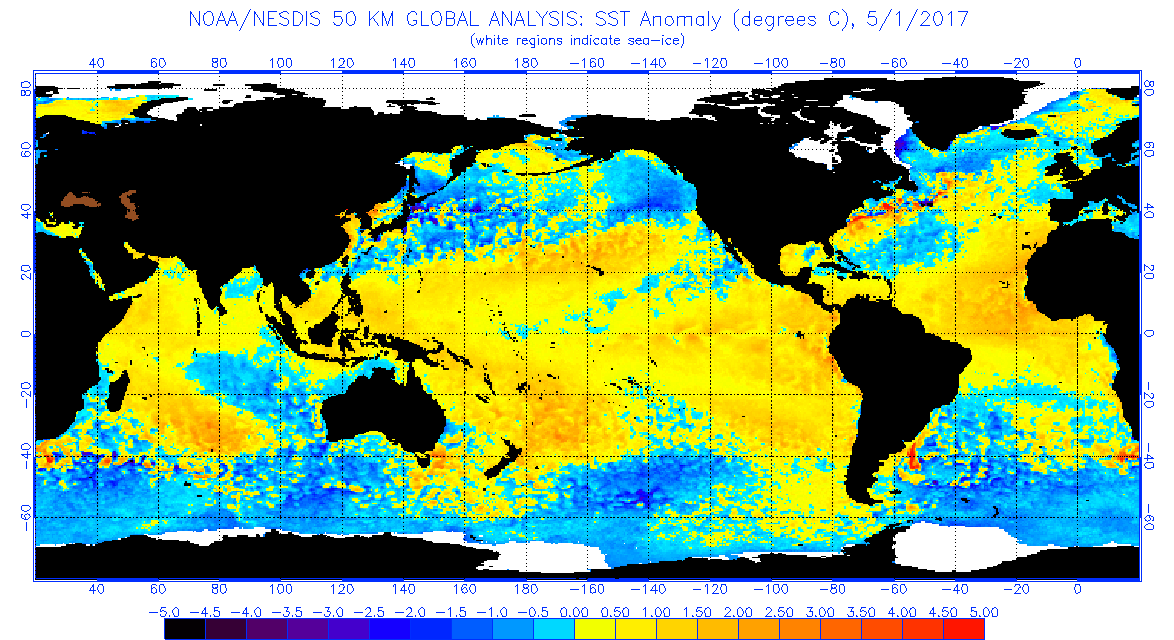
2013
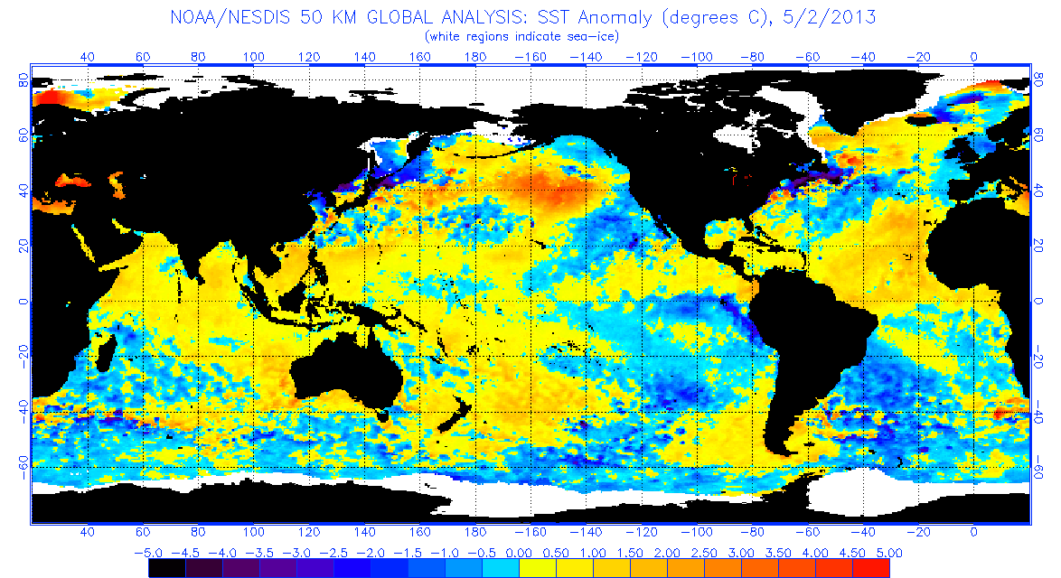
2014
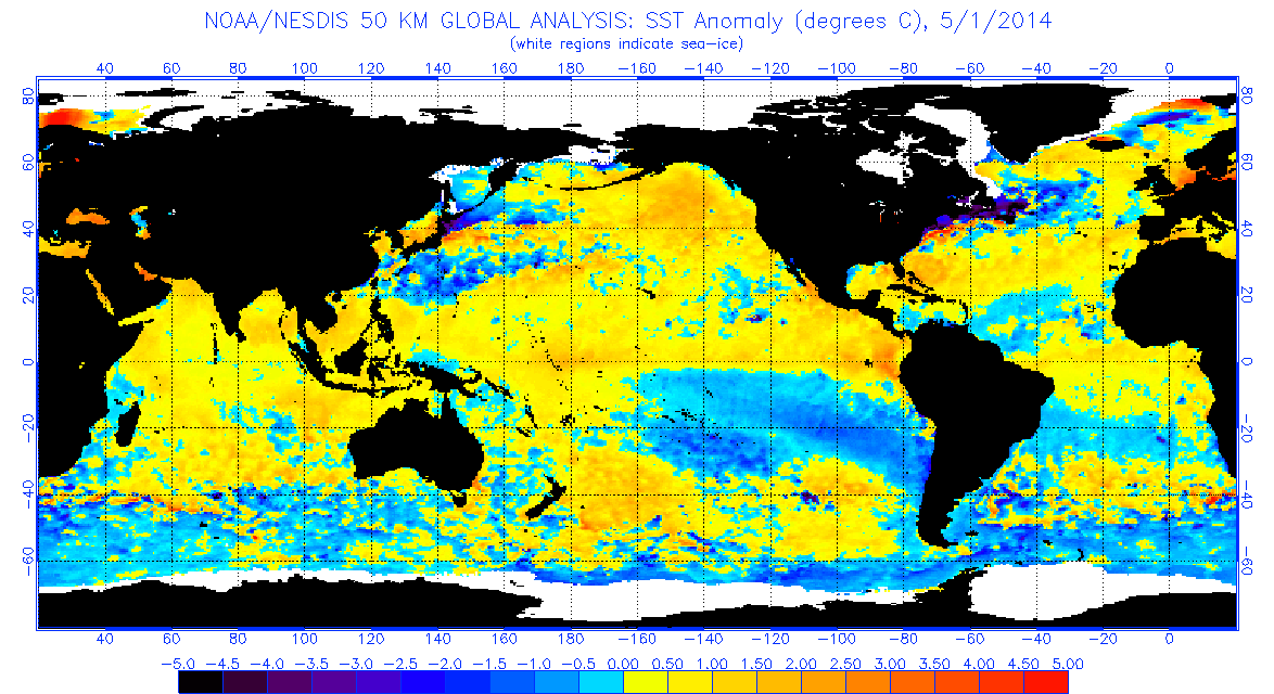
2015
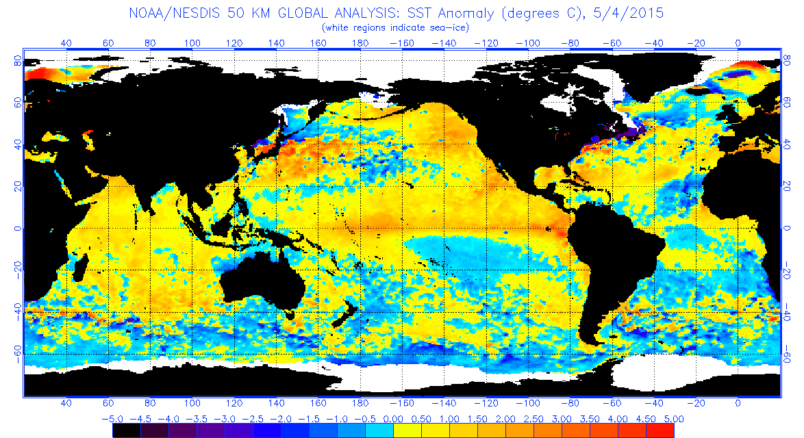
2016
2017
3 likes
The following post is NOT an official forecast and should not be used as such. It is just the opinion of the poster and may or may not be backed by sound meteorological data. It is NOT endorsed by storm2k.org.
Re: 2017 indicators: SST's / MSLP / SAL / Steering / Instability

CFS July forecast showing potentially three separate tracks--while this is still quite a ways out and I don't necessarily think these exact paths would be followed, could this be an indicator that July could be somewhat more active than in the last several years?
3 likes
The above post is not official and should not be used as such. It is the opinion of the poster and may or may not be backed by sound meteorological data. It is not endorsed by any professional institution or storm2k.org. For official information, please refer to the NHC and NWS products.
Who is online
Users browsing this forum: duilaslol, Europa non è lontana, ouragans and 158 guests