Possible development in Western Caribbean - (Is INVEST 93L)
Moderator: S2k Moderators
Forum rules

The posts in this forum are NOT official forecasts and should not be used as such. They are just the opinion of the poster and may or may not be backed by sound meteorological data. They are NOT endorsed by any professional institution or STORM2K. For official information, please refer to products from the National Hurricane Center and National Weather Service.
Re: Possible development in Western Caribbean
my gut instinct is the western solution too. i'm just content to have something of interest to watch this early in the season.
1 likes

Re: Possible development in Western Caribbean
00z GFS para doubles down on Keaton Beach Florida with a 991 mb cane on Tuesday morning.
http://www.tropicaltidbits.com/analysis/models/?model=gfsp®ion=us&pkg=mslp_pcpn_frzn&runtime=2017061700&fh=84
http://www.tropicaltidbits.com/analysis/models/?model=gfsp®ion=us&pkg=mslp_pcpn_frzn&runtime=2017061700&fh=84
2 likes
-
TheAustinMan

- Category 4

- Posts: 997
- Age: 24
- Joined: Mon Jul 08, 2013 4:26 pm
- Location: United States
- Contact:
Re: Possible development in Western Caribbean
UKMET 00z has the system forming in the Bay of Campeche/Western Gulf of Mexico in four days and then gradually moving north and gliding along the Texas coast before moving inland south of Houston - pressure is 997mb at that point.
2 likes


- Treat my opinions with a grain of salt. For official information see your local weather service.
-
stormlover2013
- Category 5

- Posts: 2312
- Joined: Thu Aug 22, 2013 12:06 pm
- Location: Lumberton, Texas

Re: Possible development in Western Caribbean
CMC landfalls around 106 hours showing 995mb Navarre/Ft Walton so Santa Rosa and Okaloosa Counties. That would be Tuesday. CMC has mostly been within 4 counties the last 3 days or so. That's pretty consistent whether it ends up right or wrong.
1 likes
-
northjaxpro

- S2K Supporter

- Posts: 8900
- Joined: Mon Sep 27, 2010 11:21 am
- Location: Jacksonville, FL
Re: Possible development in Western Caribbean
Yes the models are pretty split right now with the GFS and CMC consistently showing Eastern Gulf of Mexico and the Euro and the UK showing the Western Gulf of Mexico.
We just have to get a Low Pressure area initialized for the models to latch.onto and hopefully then we will get more unison from the models.
We just have to get a Low Pressure area initialized for the models to latch.onto and hopefully then we will get more unison from the models.
0 likes
NEVER, EVER SAY NEVER in the tropics and weather in general, and most importantly, with life itself!!
________________________________________________________________________________________
Fay 2008 Beryl 2012 Debby 2012 Colin 2016 Hermine 2016 Julia 2016 Matthew 2016 Irma 2017 Dorian 2019
________________________________________________________________________________________
Fay 2008 Beryl 2012 Debby 2012 Colin 2016 Hermine 2016 Julia 2016 Matthew 2016 Irma 2017 Dorian 2019
-
Kingarabian

- S2K Supporter
- Posts: 15434
- Joined: Sat Aug 08, 2009 3:06 am
- Location: Honolulu, Hawaii
Re: Possible development in Western Caribbean
00z Euro drops the EPAC system but still keeps the storm weak. Landfall further south into Central Mexico.
12z Euro Parallel keeps the EPAC system, but similar to the 00z Euro.
12z Euro Parallel keeps the EPAC system, but similar to the 00z Euro.
1 likes
RIP Kobe Bryant
-
bamajammer4eva
- Category 4
- Posts: 907
- Joined: Sun Apr 18, 2010 3:21 am
- Location: Ozark, AL
Re: Possible development in Western Caribbean
Kingarabian wrote:00z Euro drops the EPAC system but still keeps the storm weak. Landfall further south into Central Mexico.
12z Euro Parallel keeps the EPAC system, but similar to the 00z Euro.
Looks like it's Euro vs the rest of the world and as usual when in doubt go Euro
0 likes
Re: Possible development in Western Caribbean
Kingarabian wrote:00z Euro drops the EPAC system but still keeps the storm weak. Landfall further south into Central Mexico.
12z Euro Parallel keeps the EPAC system, but similar to the 00z Euro.
most of the model runs with a strong storm have shown baroclinic enhancement in the east Gulf. Few runs to the west Gulf, aside from the most recent UKMET or a couple of EC parallel runs, have shown much intensification. Not entirely sure I buy that unless we have strong shear in the WGOM
0 likes
-
Kingarabian
- S2K Supporter
- Posts: 15434
- Joined: Sat Aug 08, 2009 3:06 am
- Location: Honolulu, Hawaii
Re: Possible development in Western Caribbean
Alyono wrote:Kingarabian wrote:00z Euro drops the EPAC system but still keeps the storm weak. Landfall further south into Central Mexico.
12z Euro Parallel keeps the EPAC system, but similar to the 00z Euro.
most of the model runs with a strong storm have shown baroclinic enhancement in the east Gulf. Few runs to the west Gulf, aside from the most recent UKMET or a couple of EC parallel runs, have shown much intensification. Not entirely sure I buy that unless we have strong shear in the WGOM
Even when the GFS was showing a WGOM/BOC solution it kept it rather weak, compared to the strengthening trend due to the N/NE solution. So I think models are picking up on conditions in the WGOM/BOC that are not favorable.
0 likes
RIP Kobe Bryant
-
paintplaye
- Category 1

- Posts: 380
- Joined: Sun Jul 20, 2008 11:25 pm
Re: Possible development in Western Caribbean
Up to 70%

2. A broad trough of low pressure is producing a large area of
cloudiness and showers over most of Honduras and the northwestern
Caribbean Sea. Conditions appear to be favorable for gradual
development of this large disturbance while it moves slowly
northwestward across the Yucatan Peninsula this weekend and into
the south-central Gulf of Mexico early next week. Regardless of
development, heavy rains are likely to spread over portions of
Central America, the Yucatan Peninsula, and western Cuba during
the next several days.
* Formation chance through 48 hours...low...20 percent.
* Formation chance through 5 days...high...70 percent.
1 likes
Re: Possible development in Western Caribbean
Parallel MU now has a hurricane striking Florida next Tuesday
1 likes
-
Kingarabian
- S2K Supporter
- Posts: 15434
- Joined: Sat Aug 08, 2009 3:06 am
- Location: Honolulu, Hawaii
Re: Possible development in Western Caribbean
Alyono wrote:Parallel MU now has a hurricane striking Florida next Tuesday
Yeah, and 06z GFS coming in stronger, same landfall point looks like. Would be quite the coup if the GFS pulls this one off.
0 likes
RIP Kobe Bryant
Re: Possible development in Western Caribbean
Alyono wrote:Parallel MU now has a hurricane striking Florida next Tuesday
3 days away and this much spread between the GFS/Euro is nuts. If this winds up being right there won't be much prep time.
Last edited by BobHarlem on Sat Jun 17, 2017 5:30 am, edited 1 time in total.
0 likes
-
srainhoutx

- S2K Supporter
- Posts: 6919
- Age: 66
- Joined: Sun Jan 14, 2007 11:34 am
- Location: Haywood County, NC
- Contact:
Re: Possible development in Western Caribbean
An artifact of the GFS solutions is a cool front dropping South to near the Central/NE Gulf Coast. The Western camp of the ECMWF and UKMET suggest that cool front hangs up over Tennessee Valley Region.
The overnight guidance is split between two camps regarding where the NW Caribbean Tropical Disturbance may eventually track. The ECMWF suggests a broad weak system moving into Mexico near or just N of Tampico while the UKMet is a bit stronger with the disturbance moving along the Texas Coast an inland very close to the Upper Texas Coast.
The second camp of the GFS, GFS Parallel and the Canadian move the disturbance NE into Alabama/Western Florida.
There continues to be tremendous uncertainty regarding the eventual track as well as the shear axis/cool cored upper trough expected to meander West from the Central Gulf Coast toward the NW Gulf early next week. Typically we see heavier showers and thunderstorms just to the East of these Tropical Upper Tropospheric Troughs which leads to forecasting complications. Other issues such as shortwave activity dropping South out of the Central Plains and a flattening SW Heat Ridge next week with approaching upper air disturbances arriving across the Pacific NW further complicates what our sensible weather may hold.
A Reconnaissance Aircraft is scheduled to investigate the Tropical Disturbance on Monday. My hunch is we may see an INVEST designated later today as the Overnight Ensemble Tropical Cyclone Genesis Outlook has increased to a 100% chance of TC Genesis during the next 48 to 72 hours.
1 likes
Carla/Alicia/Jerry(In The Eye)/Michelle/Charley/Ivan/Dennis/Katrina/Rita/Wilma/Ike/Harvey
Member: National Weather Association
Wx Infinity Forums
http://wxinfinity.com/index.php
Facebook.com/WeatherInfinity
Twitter @WeatherInfinity
Member: National Weather Association
Wx Infinity Forums
http://wxinfinity.com/index.php
Facebook.com/WeatherInfinity
Twitter @WeatherInfinity
-
South Texas Storms

- Professional-Met

- Posts: 4005
- Joined: Thu Jun 24, 2010 12:28 am
- Location: Houston, TX
Re: Possible development in Western Caribbean
6z GFS and Parallel GFS now are showing the first signs of increased moisture and a possible tropical depression moving into Texas late next week.
1 likes
-
cycloneye

- Admin

- Posts: 139060
- Age: 67
- Joined: Thu Oct 10, 2002 10:54 am
- Location: San Juan, Puerto Rico
Re: Possible development in Western Caribbean
A broad trough of low pressure is producing a large area of
cloudiness and showers over the northwestern Caribbean Sea and the
adjacent land areas. Conditions appear to be favorable for gradual
development of this large disturbance while it moves slowly
northwestward across the Yucatan Peninsula this weekend, and a
tropical cyclone could form early next week over the southern or
central Gulf of Mexico. Regardless of development, heavy rains are
likely to spread over portions of Central America, the Yucatan
Peninsula, Jamaica, the Cayman Islands, and western Cuba during the
next several days.
* Formation chance through 48 hours...low...20 percent.
* Formation chance through 5 days...high...70 percent
0 likes
Visit the Caribbean-Central America Weather Thread where you can find at first post web cams,radars
and observations from Caribbean basin members Click Here
and observations from Caribbean basin members Click Here

Re: Possible development in Western Caribbean
Kingarabian wrote:00z Euro drops the EPAC system but still keeps the storm weak. Landfall further south into Central Mexico.
12z Euro Parallel keeps the EPAC system, but similar to the 00z Euro.
0z Euro does not have it making landfall in central MX, it keeps the energy offshore and then has it going up the coast of MX just south of Brownsville, it paints a very wet picture for the whole TX coast at the end of next week.
Last edited by NDG on Sat Jun 17, 2017 7:24 am, edited 1 time in total.
2 likes
-
tropicwatch

- Category 5
- Posts: 3205
- Age: 60
- Joined: Sat Jun 02, 2007 10:01 am
- Location: Panama City Florida
- Contact:
Re: Possible development in Western Caribbean
With a broad circulation becoming more evident, I would think we would see an invest number pretty soon.
https://weather.msfc.nasa.gov/cgi-bin/get-goes?satellite=GOES-E%20CONUS&lat=20&lon=-84&type=Animation&palette=ir2.pal&numframes=10&zoom=2
https://weather.msfc.nasa.gov/cgi-bin/get-goes?satellite=GOES-E%20CONUS&lat=20&lon=-84&type=Animation&palette=ir2.pal&numframes=10&zoom=2
0 likes
Tropicwatch
Agnes 72', Eloise 75, Elena 85', Kate 85', Charley 86', Florence 88', Beryl 94', Dean 95', Erin 95', Opal 95', Earl 98', Georges 98', Ivan 2004', Arlene 2005', Dennis 2005', Ida 2009' Debby 2012' Irma 2017' Michael 2018'
Agnes 72', Eloise 75, Elena 85', Kate 85', Charley 86', Florence 88', Beryl 94', Dean 95', Erin 95', Opal 95', Earl 98', Georges 98', Ivan 2004', Arlene 2005', Dennis 2005', Ida 2009' Debby 2012' Irma 2017' Michael 2018'
Re: Possible development in Western Caribbean
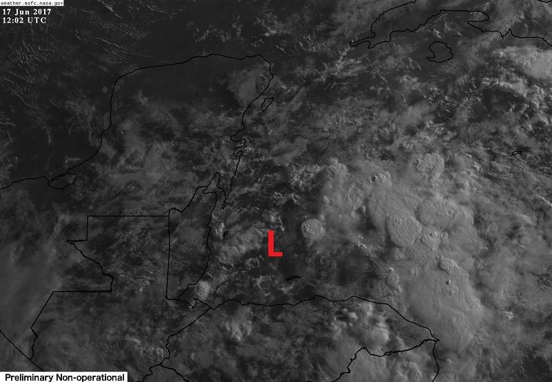
First visible goes 16 satellite loop and surface reports indicate that the broad surface circulation is in the BOH approximately where I placed the L. IMO.
Buoys in the NW continue to show falling pressures this morning compared to 24 hrs ago.
Buoys in the NW continue to show falling pressures this morning compared to 24 hrs ago.
0 likes
Who is online
Users browsing this forum: Europa non è lontana, Hurricane Jed, hurricanes1234, StPeteMike, weeniepatrol and 162 guests