Disturbance over the SW GOMEX
Moderator: S2k Moderators
Forum rules

The posts in this forum are NOT official forecasts and should not be used as such. They are just the opinion of the poster and may or may not be backed by sound meteorological data. They are NOT endorsed by any professional institution or STORM2K. For official information, please refer to products from the National Hurricane Center and National Weather Service.
-
lrak

- S2K Supporter

- Posts: 1770
- Age: 57
- Joined: Thu Jun 21, 2007 2:48 pm
- Location: Corpus Christi, TX
Disturbance over the SW GOMEX
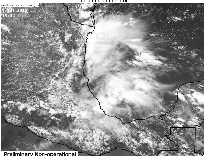
I was looking at all the convection in the W GOM and noticed a LL swirl just NE of Villahermosa? Now at 4:50 CDT pressure has dropped at the BOC buoy. Does this have lots of shear or something?
Last edited by lrak on Fri Jul 07, 2017 5:53 pm, edited 1 time in total.
0 likes
AKA karl
Also
Personal Forecast Disclaimer:
My posts on this forum are NOT official forecast and should not be used as such. My posts are my basic observations and are definitely not backed by any "well some" meteorological knowledge. For official information, please refer to the NHC and NWS products.
Also
Personal Forecast Disclaimer:
My posts on this forum are NOT official forecast and should not be used as such. My posts are my basic observations and are definitely not backed by any "well some" meteorological knowledge. For official information, please refer to the NHC and NWS products.
-
tropicwatch

- Category 5

- Posts: 3205
- Age: 60
- Joined: Sat Jun 02, 2007 10:01 am
- Location: Panama City Florida
- Contact:
Re: Disturbance over the SW GOMEX
The convection in the southwest gom and boc have caught my attention this afternoon.
0 likes
Tropicwatch
Agnes 72', Eloise 75, Elena 85', Kate 85', Charley 86', Florence 88', Beryl 94', Dean 95', Erin 95', Opal 95', Earl 98', Georges 98', Ivan 2004', Arlene 2005', Dennis 2005', Ida 2009' Debby 2012' Irma 2017' Michael 2018'
Agnes 72', Eloise 75, Elena 85', Kate 85', Charley 86', Florence 88', Beryl 94', Dean 95', Erin 95', Opal 95', Earl 98', Georges 98', Ivan 2004', Arlene 2005', Dennis 2005', Ida 2009' Debby 2012' Irma 2017' Michael 2018'

Re: Disturbance over the SW GOMEX
From just looking at that satellite loop, the shear is way too high, and I don't see any circulation at any level.
0 likes
Personal Forecast Disclaimer:
The posts in this forum are NOT official forecast and should not be used as such. They are just the opinion of the poster and may or may not be backed by sound meteorological data. They are NOT endorsed by any professional institution or storm2k.org. For official information, please refer to the NHC and NWS products.
The posts in this forum are NOT official forecast and should not be used as such. They are just the opinion of the poster and may or may not be backed by sound meteorological data. They are NOT endorsed by any professional institution or storm2k.org. For official information, please refer to the NHC and NWS products.
-
lrak
- S2K Supporter
- Posts: 1770
- Age: 57
- Joined: Thu Jun 21, 2007 2:48 pm
- Location: Corpus Christi, TX
Re: Disturbance over the SW GOMEX
Last edited by lrak on Sat Jul 08, 2017 5:02 pm, edited 2 times in total.
0 likes
AKA karl
Also
Personal Forecast Disclaimer:
My posts on this forum are NOT official forecast and should not be used as such. My posts are my basic observations and are definitely not backed by any "well some" meteorological knowledge. For official information, please refer to the NHC and NWS products.
Also
Personal Forecast Disclaimer:
My posts on this forum are NOT official forecast and should not be used as such. My posts are my basic observations and are definitely not backed by any "well some" meteorological knowledge. For official information, please refer to the NHC and NWS products.

Re: Disturbance over the SW GOMEX
Looks mostly inland so it may not be destined for the gulf.
Is there any model support?
Is there any model support?
0 likes
-
lrak
- S2K Supporter
- Posts: 1770
- Age: 57
- Joined: Thu Jun 21, 2007 2:48 pm
- Location: Corpus Christi, TX
Re: Disturbance over the SW GOMEX
Nimbus wrote:Looks mostly inland so it may not be destined for the gulf.
Is there any model support?
None that I know of? It's really starting to look like a center is trying to form. I only use the satellites and radars for my forecast LOL
Also I see a lot of inflow into that large blob. Maybe the low is getting sucked under it?
1 likes
AKA karl
Also
Personal Forecast Disclaimer:
My posts on this forum are NOT official forecast and should not be used as such. My posts are my basic observations and are definitely not backed by any "well some" meteorological knowledge. For official information, please refer to the NHC and NWS products.
Also
Personal Forecast Disclaimer:
My posts on this forum are NOT official forecast and should not be used as such. My posts are my basic observations and are definitely not backed by any "well some" meteorological knowledge. For official information, please refer to the NHC and NWS products.
-
lrak
- S2K Supporter
- Posts: 1770
- Age: 57
- Joined: Thu Jun 21, 2007 2:48 pm
- Location: Corpus Christi, TX
Re: Disturbance over the SW GOMEX
as the BOC churns....that new tower has my interest. See if it persists tonight, so much rain with so much high pressure?
Well now it looks like the S BOC is starting back up. Last evening all the convection was waning but this evening we still have some convection.
Well now it looks like the S BOC is starting back up. Last evening all the convection was waning but this evening we still have some convection.
0 likes
AKA karl
Also
Personal Forecast Disclaimer:
My posts on this forum are NOT official forecast and should not be used as such. My posts are my basic observations and are definitely not backed by any "well some" meteorological knowledge. For official information, please refer to the NHC and NWS products.
Also
Personal Forecast Disclaimer:
My posts on this forum are NOT official forecast and should not be used as such. My posts are my basic observations and are definitely not backed by any "well some" meteorological knowledge. For official information, please refer to the NHC and NWS products.
-
Dean4Storms
- S2K Supporter
- Posts: 6355
- Age: 61
- Joined: Sun Aug 31, 2003 1:01 pm
- Location: Miramar Bch. FL
Re: Disturbance over the SW GOMEX
Stu Ostro on Twitter posted a pic about there being a spin at mid level and something to keep an eye on for now that in the tropics surprises are always possible.
0 likes
Re: Disturbance over the SW GOMEX
The GFS has high pressure north of it in 24 hours which might steer whatever is on the coast inland.
1 likes
Who is online
Users browsing this forum: Cpv17, cycloneye, Google [Bot], KirbyDude25, tiger_deF and 186 guests