Another GOM Disturbance
Moderator: S2k Moderators
Forum rules

The posts in this forum are NOT official forecasts and should not be used as such. They are just the opinion of the poster and may or may not be backed by sound meteorological data. They are NOT endorsed by any professional institution or STORM2K. For official information, please refer to products from the National Hurricane Center and National Weather Service.
-
lrak

- S2K Supporter

- Posts: 1770
- Age: 57
- Joined: Thu Jun 21, 2007 2:48 pm
- Location: Corpus Christi, TX
Another GOM Disturbance
Located around 25.49N 88.92W it's right on the heals of Emily. Is that possible?
0 likes
AKA karl
Also
Personal Forecast Disclaimer:
My posts on this forum are NOT official forecast and should not be used as such. My posts are my basic observations and are definitely not backed by any "well some" meteorological knowledge. For official information, please refer to the NHC and NWS products.
Also
Personal Forecast Disclaimer:
My posts on this forum are NOT official forecast and should not be used as such. My posts are my basic observations and are definitely not backed by any "well some" meteorological knowledge. For official information, please refer to the NHC and NWS products.
-
floridasun78
- Category 5

- Posts: 3755
- Joined: Sun May 17, 2009 10:16 pm
- Location: miami fl
Re: Another GOM Disturbance
lrak wrote:Located around 25.49N 88.92W it's right on the heals of Emily. Is that possible?
not thing their only rain band of Emily moving east
0 likes
-
lrak
- S2K Supporter
- Posts: 1770
- Age: 57
- Joined: Thu Jun 21, 2007 2:48 pm
- Location: Corpus Christi, TX
Re: Another GOM Disturbance
floridasun78 wrote:lrak wrote:Located around 25.49N 88.92W it's right on the heals of Emily. Is that possible?
not thing their only rain band of Emily moving east
thank you....NetFlix time LOL
0 likes
AKA karl
Also
Personal Forecast Disclaimer:
My posts on this forum are NOT official forecast and should not be used as such. My posts are my basic observations and are definitely not backed by any "well some" meteorological knowledge. For official information, please refer to the NHC and NWS products.
Also
Personal Forecast Disclaimer:
My posts on this forum are NOT official forecast and should not be used as such. My posts are my basic observations and are definitely not backed by any "well some" meteorological knowledge. For official information, please refer to the NHC and NWS products.
-
northjaxpro

- S2K Supporter
- Posts: 8900
- Joined: Mon Sep 27, 2010 11:21 am
- Location: Jacksonville, FL
Re: Another GOM Disturbance
There is quite an elongated trough extending all across the the GOM from west to east. It would not be beyond any stretch of the imagination that another vortex could spin up along that trough axis.
It is something to watch as the week progresses.
It is something to watch as the week progresses.
0 likes
NEVER, EVER SAY NEVER in the tropics and weather in general, and most importantly, with life itself!!
________________________________________________________________________________________
Fay 2008 Beryl 2012 Debby 2012 Colin 2016 Hermine 2016 Julia 2016 Matthew 2016 Irma 2017 Dorian 2019
________________________________________________________________________________________
Fay 2008 Beryl 2012 Debby 2012 Colin 2016 Hermine 2016 Julia 2016 Matthew 2016 Irma 2017 Dorian 2019

Re: Another GOM Disturbance
A few of the models are suggesting another low could develop somewhere along the old frontal trough. all keep it weak or dissipate it. I just want to start a new thread to keep us out of the Emily thread.


0 likes
The following post is NOT an official forecast and should not be used as such. It is just the opinion of the poster and may or may not be backed by sound meteorological data. It is NOT endorsed by any professional institution including storm2k.org For Official Information please refer to the NHC and NWS products.
-
lrak
- S2K Supporter
- Posts: 1770
- Age: 57
- Joined: Thu Jun 21, 2007 2:48 pm
- Location: Corpus Christi, TX
Re: Another GOM Disturbance
Oooh model support. Dangit no NetFlix for now. LOL
this buoy is right under that red blow up in the central GOM http://www.ndbc.noaa.gov/station_page.php?station=42001
this buoy is right under that red blow up in the central GOM http://www.ndbc.noaa.gov/station_page.php?station=42001
2 likes
AKA karl
Also
Personal Forecast Disclaimer:
My posts on this forum are NOT official forecast and should not be used as such. My posts are my basic observations and are definitely not backed by any "well some" meteorological knowledge. For official information, please refer to the NHC and NWS products.
Also
Personal Forecast Disclaimer:
My posts on this forum are NOT official forecast and should not be used as such. My posts are my basic observations and are definitely not backed by any "well some" meteorological knowledge. For official information, please refer to the NHC and NWS products.
-
lrak
- S2K Supporter
- Posts: 1770
- Age: 57
- Joined: Thu Jun 21, 2007 2:48 pm
- Location: Corpus Christi, TX
Re: Another GOM Disturbance
The blob is look healthy this late in the evening.
0 likes
AKA karl
Also
Personal Forecast Disclaimer:
My posts on this forum are NOT official forecast and should not be used as such. My posts are my basic observations and are definitely not backed by any "well some" meteorological knowledge. For official information, please refer to the NHC and NWS products.
Also
Personal Forecast Disclaimer:
My posts on this forum are NOT official forecast and should not be used as such. My posts are my basic observations and are definitely not backed by any "well some" meteorological knowledge. For official information, please refer to the NHC and NWS products.
-
lrak
- S2K Supporter
- Posts: 1770
- Age: 57
- Joined: Thu Jun 21, 2007 2:48 pm
- Location: Corpus Christi, TX
Re: Another GOM Disturbance
tailgater wrote:A few of the models are suggesting another low could develop somewhere along the old frontal trough. all keep it weak or dissipate it. I just want to start a new thread to keep us out of the Emily thread.
thanks for posting the model support tailgater
0 likes
AKA karl
Also
Personal Forecast Disclaimer:
My posts on this forum are NOT official forecast and should not be used as such. My posts are my basic observations and are definitely not backed by any "well some" meteorological knowledge. For official information, please refer to the NHC and NWS products.
Also
Personal Forecast Disclaimer:
My posts on this forum are NOT official forecast and should not be used as such. My posts are my basic observations and are definitely not backed by any "well some" meteorological knowledge. For official information, please refer to the NHC and NWS products.

Re: Another GOM Disturbance
Doesn't look like much will come out of this. My best guess would be one or two minor lows spin up in the next 3-4 days. I've seen 18z solutions showing TX, LA and FL as well as just return flow surge.
0 likes
-
bamajammer4eva
- Category 4

- Posts: 907
- Joined: Sun Apr 18, 2010 3:21 am
- Location: Ozark, AL


Re: Another GOM Disturbance
puff puff puff the convection has continued in that same area for over 24 hours and there was a hint in the low clouds last night that a circulation might be developing. Could end up in the active forum sometime today.
0 likes
-
Dean4Storms
- S2K Supporter
- Posts: 6355
- Age: 61
- Joined: Sun Aug 31, 2003 1:01 pm
- Location: Miramar Bch. FL
Re: Another GOM Disturbance
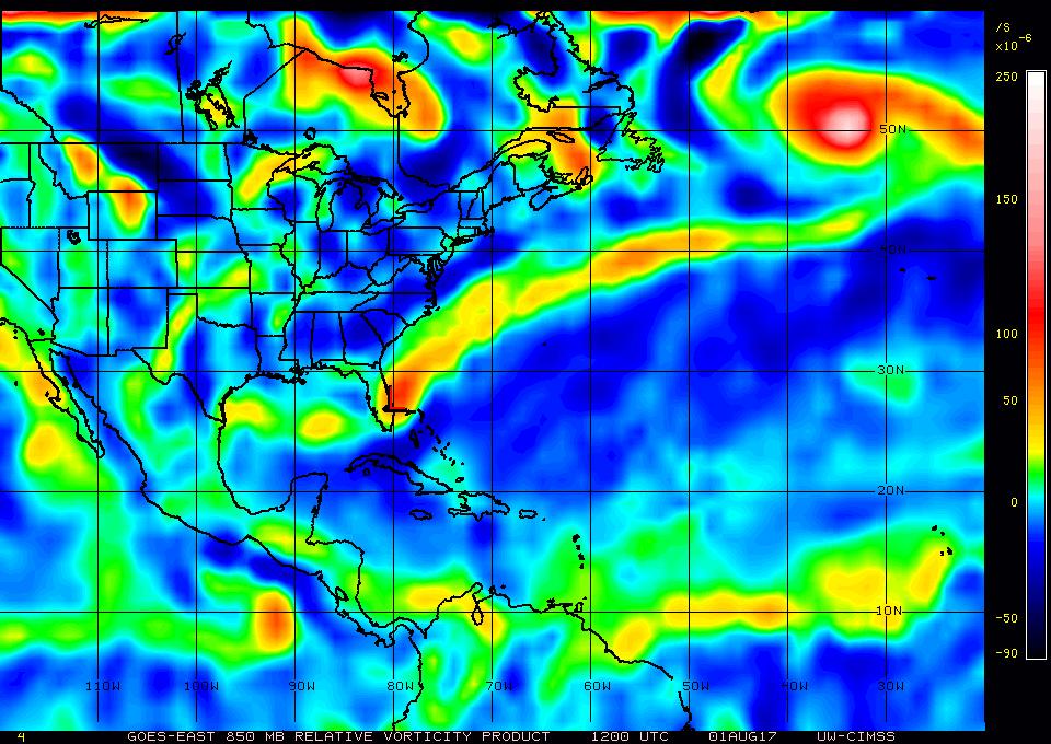
Still some slight vorticity there this morning, if convection increases today and shear relaxes it could get some organization going. Something to watch.
1 likes
-
tropicwatch

- Category 5
- Posts: 3205
- Age: 60
- Joined: Sat Jun 02, 2007 10:01 am
- Location: Panama City Florida
- Contact:
Re: Another GOM Disturbance
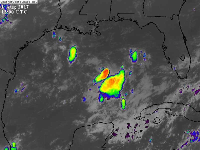
The shower activity and 850mb vorticity seem to be hand in hand this morning.
1 likes
Tropicwatch
Agnes 72', Eloise 75, Elena 85', Kate 85', Charley 86', Florence 88', Beryl 94', Dean 95', Erin 95', Opal 95', Earl 98', Georges 98', Ivan 2004', Arlene 2005', Dennis 2005', Ida 2009' Debby 2012' Irma 2017' Michael 2018'
Agnes 72', Eloise 75, Elena 85', Kate 85', Charley 86', Florence 88', Beryl 94', Dean 95', Erin 95', Opal 95', Earl 98', Georges 98', Ivan 2004', Arlene 2005', Dennis 2005', Ida 2009' Debby 2012' Irma 2017' Michael 2018'
-
lrak
- S2K Supporter
- Posts: 1770
- Age: 57
- Joined: Thu Jun 21, 2007 2:48 pm
- Location: Corpus Christi, TX
Re: Another GOM Disturbance
South Texas sure needs some rain. Which way will this thing go if it forms into a depression?
0 likes
AKA karl
Also
Personal Forecast Disclaimer:
My posts on this forum are NOT official forecast and should not be used as such. My posts are my basic observations and are definitely not backed by any "well some" meteorological knowledge. For official information, please refer to the NHC and NWS products.
Also
Personal Forecast Disclaimer:
My posts on this forum are NOT official forecast and should not be used as such. My posts are my basic observations and are definitely not backed by any "well some" meteorological knowledge. For official information, please refer to the NHC and NWS products.
Re: Another GOM Disturbance
lrak wrote:South Texas sure needs some rain. Which way will this thing go if it forms into a depression?
Hey Karl. NAM says Apalachicola. RGEM splits the energy with one piece going following the wake of Emily with another piece moving toward Santa Rosa County, FL.
Last edited by Steve on Tue Aug 01, 2017 9:32 am, edited 1 time in total.
1 likes
-
Stormcenter
- S2K Supporter
- Posts: 6617
- Joined: Wed Sep 03, 2003 11:27 am
- Location: Houston, TX
Re: Another GOM Disturbance
it sure looks like something may be trying to get itself organized this morning in the central Gulf. IMO
http://www.ssd.noaa.gov/goes/east/gmex/h5-loop-vis.html
http://www.ssd.noaa.gov/goes/east/gmex/h5-loop-vis.html
1 likes
-
lrak
- S2K Supporter
- Posts: 1770
- Age: 57
- Joined: Thu Jun 21, 2007 2:48 pm
- Location: Corpus Christi, TX
Re: Another GOM Disturbance
Steve wrote:lrak wrote:South Texas sure needs some rain. Which way will this thing go if it forms into a depression?
Hey Karl. NAM says Apalachicola. RGEM splits the energy with one piece going following the wake of Emily with another piece moving toward Santa Rosa Beach.
thank you Steve
1 likes
AKA karl
Also
Personal Forecast Disclaimer:
My posts on this forum are NOT official forecast and should not be used as such. My posts are my basic observations and are definitely not backed by any "well some" meteorological knowledge. For official information, please refer to the NHC and NWS products.
Also
Personal Forecast Disclaimer:
My posts on this forum are NOT official forecast and should not be used as such. My posts are my basic observations and are definitely not backed by any "well some" meteorological knowledge. For official information, please refer to the NHC and NWS products.
-
gatorcane

- S2K Supporter
- Posts: 23499
- Age: 46
- Joined: Sun Mar 13, 2005 3:54 pm
- Location: Boca Raton, FL
Re: Another GOM Disturbance
I agree it looks intriguing but the shear is keeping it in check for now and by the time the shear settles down it probably will be inland according to the models. I don't see one model that develops it either probably for those reasons.
0 likes
-
lrak
- S2K Supporter
- Posts: 1770
- Age: 57
- Joined: Thu Jun 21, 2007 2:48 pm
- Location: Corpus Christi, TX
Re: Another GOM Disturbance
Stormcenter wrote:it sure looks like something may be trying to get itself organized this morning in the central Gulf. IMO
http://www.ssd.noaa.gov/goes/east/gmex/h5-loop-vis.html
I agree the buoy to it's west is showing a west wind now.
1 likes
AKA karl
Also
Personal Forecast Disclaimer:
My posts on this forum are NOT official forecast and should not be used as such. My posts are my basic observations and are definitely not backed by any "well some" meteorological knowledge. For official information, please refer to the NHC and NWS products.
Also
Personal Forecast Disclaimer:
My posts on this forum are NOT official forecast and should not be used as such. My posts are my basic observations and are definitely not backed by any "well some" meteorological knowledge. For official information, please refer to the NHC and NWS products.
-
Stormcenter
- S2K Supporter
- Posts: 6617
- Joined: Wed Sep 03, 2003 11:27 am
- Location: Houston, TX
Re: Another GOM Disturbance
But remember no model saw Emily forming just had it as a low pressure system....just saying.
gatorcane wrote:I agree it looks intriguing but the shear is keeping it in check for now and by the time the shear settles down it probably will be inland according to the models. I don't see one model that develops it either probably for those reasons.
2 likes
Who is online
Users browsing this forum: Beef Stew, Hurricane2022, MetroMike and 51 guests