Low in SE Texas
Moderator: S2k Moderators
Forum rules
The posts in this forum are NOT official forecasts and should not be used as such. They are just the opinion of the poster and may or may not be backed by sound meteorological data. They are NOT endorsed by any professional institution or STORM2K. For official information, please refer to products from the National Hurricane Center and National Weather Service.
- CFLHurricane
- Category 1

- Posts: 312
- Joined: Thu Mar 27, 2014 5:56 pm
- Location: Floriduh
Low in SE Texas
This low appears on the (awesome) GOES 16 feed to be dropping further south than the surface chart seems to forecast. Possible Gulf threat?
0 likes
I'm not a meteorologist, but I did stay at a motel 8.
- lrak
- S2K Supporter

- Posts: 1770
- Age: 57
- Joined: Thu Jun 21, 2007 2:48 pm
- Location: Corpus Christi, TX
Re: Low in SE Texas
I've been watching it all day and I found in SE Texas a NE wind, SW wind, calm wind in the middle of the rotation, and a N wind. Also it has pushed thunderstorms offshore and not due to outflow boundaries? Emily part-deux?
https://radar.weather.gov/radar.php?pro ... x&loop=yes yet the lowest pressure I could find was 29.95.
https://radar.weather.gov/radar.php?pro ... x&loop=yes yet the lowest pressure I could find was 29.95.
0 likes
AKA karl
Also
Personal Forecast Disclaimer:
My posts on this forum are NOT official forecast and should not be used as such. My posts are my basic observations and are definitely not backed by any "well some" meteorological knowledge. For official information, please refer to the NHC and NWS products.
Also
Personal Forecast Disclaimer:
My posts on this forum are NOT official forecast and should not be used as such. My posts are my basic observations and are definitely not backed by any "well some" meteorological knowledge. For official information, please refer to the NHC and NWS products.
- northjaxpro
- S2K Supporter

- Posts: 8900
- Joined: Mon Sep 27, 2010 11:21 am
- Location: Jacksonville, FL
Re: Low in SE Texas
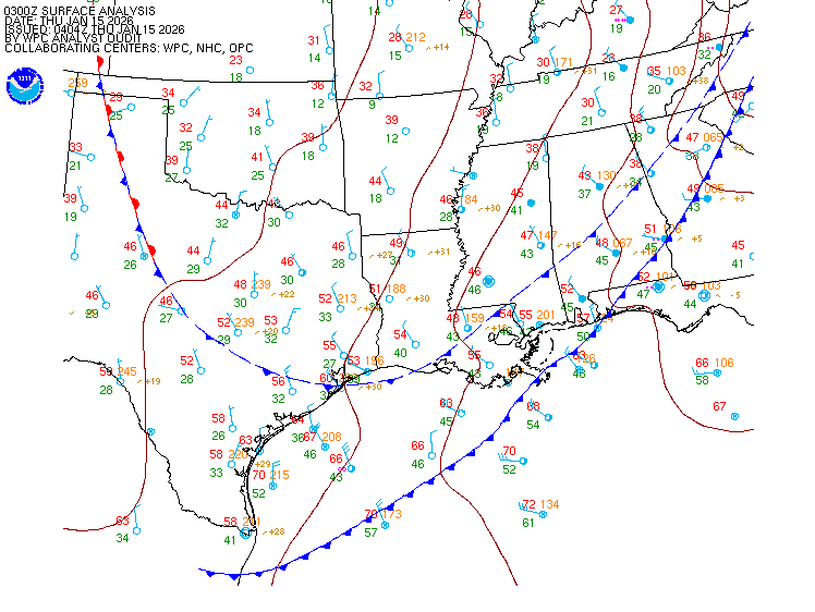
It is a 1012 mb non tropical Low Pressure area located near Galveston on a stationary frontal boundary . No development anticipated for the time being.


0 likes
NEVER, EVER SAY NEVER in the tropics and weather in general, and most importantly, with life itself!!
________________________________________________________________________________________
Fay 2008 Beryl 2012 Debby 2012 Colin 2016 Hermine 2016 Julia 2016 Matthew 2016 Irma 2017 Dorian 2019
________________________________________________________________________________________
Fay 2008 Beryl 2012 Debby 2012 Colin 2016 Hermine 2016 Julia 2016 Matthew 2016 Irma 2017 Dorian 2019
- lrak
- S2K Supporter

- Posts: 1770
- Age: 57
- Joined: Thu Jun 21, 2007 2:48 pm
- Location: Corpus Christi, TX
Re: Low in SE Texas
"No development anticipated for the time being." I like that last sentence it gives us something to watch. Thanks for the nice map!
0 likes
AKA karl
Also
Personal Forecast Disclaimer:
My posts on this forum are NOT official forecast and should not be used as such. My posts are my basic observations and are definitely not backed by any "well some" meteorological knowledge. For official information, please refer to the NHC and NWS products.
Also
Personal Forecast Disclaimer:
My posts on this forum are NOT official forecast and should not be used as such. My posts are my basic observations and are definitely not backed by any "well some" meteorological knowledge. For official information, please refer to the NHC and NWS products.
- northjaxpro
- S2K Supporter

- Posts: 8900
- Joined: Mon Sep 27, 2010 11:21 am
- Location: Jacksonville, FL
Re: Low in SE Texas
I will note that Flash Flood Watch in effect through tomorrow for much of Southeast TX region and rightfully so as Low Pressure area is just sitting there basically stationary, along with the frontal boundary. All that converging moisture in that region.
0 likes
NEVER, EVER SAY NEVER in the tropics and weather in general, and most importantly, with life itself!!
________________________________________________________________________________________
Fay 2008 Beryl 2012 Debby 2012 Colin 2016 Hermine 2016 Julia 2016 Matthew 2016 Irma 2017 Dorian 2019
________________________________________________________________________________________
Fay 2008 Beryl 2012 Debby 2012 Colin 2016 Hermine 2016 Julia 2016 Matthew 2016 Irma 2017 Dorian 2019
- lrak
- S2K Supporter

- Posts: 1770
- Age: 57
- Joined: Thu Jun 21, 2007 2:48 pm
- Location: Corpus Christi, TX
Re: Low in SE Texas
Yes I watched a video today of the flooding. Very bad situation, and I'm afraid if this moves a little closer to the coast even more moisture 
The radar is looking like something wants free from the frontal boundary.
The radar is looking like something wants free from the frontal boundary.
0 likes
AKA karl
Also
Personal Forecast Disclaimer:
My posts on this forum are NOT official forecast and should not be used as such. My posts are my basic observations and are definitely not backed by any "well some" meteorological knowledge. For official information, please refer to the NHC and NWS products.
Also
Personal Forecast Disclaimer:
My posts on this forum are NOT official forecast and should not be used as such. My posts are my basic observations and are definitely not backed by any "well some" meteorological knowledge. For official information, please refer to the NHC and NWS products.
Re: Low in SE Texas
lrak wrote:Yes I watched a video today of the flooding. Very bad situation, and I'm afraid if this moves a little closer to the coast even more moisture
I hope not. We've had 3 flash flood warnings (including #3 at the moment) in the last 2 weeks and have been nowhere as wet as 3-400 miles east of here. It's cost us 2 flooded cars out of 3 but luckily just mildewed floors and not flooded engines. There are apparently 8 broken pumping stations at the moment waiting on parts. That's probably not ideal heading into the beginning of the middle of August. I don't want to be on the east side of any low be it tropical or otherwise.
NAM doesn't do much with it. 12km shows another low dropping down from the Northern Rockies over the next couple of days - more toward Arkansas though. That could be the feature that enforces the front on the east coast and hopefully helps 99L recurve. HRR does show continued rains for Lake Charles and the Triangle over the next 18 hours, so y'all be careful over that way.
1 likes
- lrak
- S2K Supporter

- Posts: 1770
- Age: 57
- Joined: Thu Jun 21, 2007 2:48 pm
- Location: Corpus Christi, TX
Re: Low in SE Texas
Steve wrote:lrak wrote:Yes I watched a video today of the flooding. Very bad situation, and I'm afraid if this moves a little closer to the coast even more moisture
I hope not. We've had 3 flash flood warnings (including #3 at the moment) in the last 2 weeks and have been nowhere as wet as 3-400 miles east of here. It's cost us 2 flooded cars out of 3 but luckily just mildewed floors and not flooded engines. There are apparently 8 broken pumping stations at the moment waiting on parts. That's probably not ideal heading into the beginning of the middle of August. I don't want to be on the east side of any low be it tropical or otherwise.
NAM doesn't do much with it though 12km shows another low dropping down from the Northern Rockies over the next couple of days. That could be the feature that enforces the front on the east coast and hopefully helps 99L recurve. HRR does show continued rains for Lake Charles and the Triangle over the next 18 hours, so y'all be careful over that way.
Wow, glad the engines didn't get hit but mildew - only Clorox and some water mixed in a spray bottle - is your best bet with no drying in the up coming days. Good luck.
1 likes
AKA karl
Also
Personal Forecast Disclaimer:
My posts on this forum are NOT official forecast and should not be used as such. My posts are my basic observations and are definitely not backed by any "well some" meteorological knowledge. For official information, please refer to the NHC and NWS products.
Also
Personal Forecast Disclaimer:
My posts on this forum are NOT official forecast and should not be used as such. My posts are my basic observations and are definitely not backed by any "well some" meteorological knowledge. For official information, please refer to the NHC and NWS products.
- lrak
- S2K Supporter

- Posts: 1770
- Age: 57
- Joined: Thu Jun 21, 2007 2:48 pm
- Location: Corpus Christi, TX
Re: Low in SE Texas
some interesting weather reporting stations. http://www.ndbc.noaa.gov/station_page.php?station=ncht2 Offshore - http://www.ndbc.noaa.gov/station_page.php?station=42035
I hope this dissipates. Just west of the triangle they've received close to 6 inches based off Doppler radar.
Also convection has been on the increase and the virga has also increased to the west of Houston's radar which may indicate a larger disturbance?
It's about 10:15 pm and the virga now has a new cell starting up, this could get messy. Also when the virga hits the coast it starts to produce convection.
0 likes
AKA karl
Also
Personal Forecast Disclaimer:
My posts on this forum are NOT official forecast and should not be used as such. My posts are my basic observations and are definitely not backed by any "well some" meteorological knowledge. For official information, please refer to the NHC and NWS products.
Also
Personal Forecast Disclaimer:
My posts on this forum are NOT official forecast and should not be used as such. My posts are my basic observations and are definitely not backed by any "well some" meteorological knowledge. For official information, please refer to the NHC and NWS products.
- lrak
- S2K Supporter

- Posts: 1770
- Age: 57
- Joined: Thu Jun 21, 2007 2:48 pm
- Location: Corpus Christi, TX
Re: Low in SE Texas
https://weather.msfc.nasa.gov/cgi-bin/get-goes?satellite=GOES-E%20CONUS&lat=29.41&lon=-94.14&info=ir&zoom=1&width=1400&height=1000&quality=90&type=Animation&palette=ir2.pal&numframes=30&mapcolor=yellow
it's kinda late for this convection to continue?
water vapor loop
https://weather.msfc.nasa.gov/cgi-bin/get-goes?satellite=GOES-E%20CONUS&lat=29.41&lon=-94.14&info=wv&zoom=1&width=1400&height=1000&quality=90&type=Animation&palette=ir2.pal&numframes=30&mapcolor=yellow
it's kinda late for this convection to continue?
water vapor loop
https://weather.msfc.nasa.gov/cgi-bin/get-goes?satellite=GOES-E%20CONUS&lat=29.41&lon=-94.14&info=wv&zoom=1&width=1400&height=1000&quality=90&type=Animation&palette=ir2.pal&numframes=30&mapcolor=yellow
0 likes
AKA karl
Also
Personal Forecast Disclaimer:
My posts on this forum are NOT official forecast and should not be used as such. My posts are my basic observations and are definitely not backed by any "well some" meteorological knowledge. For official information, please refer to the NHC and NWS products.
Also
Personal Forecast Disclaimer:
My posts on this forum are NOT official forecast and should not be used as such. My posts are my basic observations and are definitely not backed by any "well some" meteorological knowledge. For official information, please refer to the NHC and NWS products.
Who is online
Users browsing this forum: CFLHurricane, FLCrackerGirl, MetroMike, NotSparta and 64 guests


