NE Gulf disturbance

This is the general tropical discussion area. Anyone can take their shot at predicting a storms path.

Moderator: S2k Moderators

Forum rules

The posts in this forum are NOT official forecasts and should not be used as such. They are just the opinion of the poster and may or may not be backed by sound meteorological data. They are NOT endorsed by any professional institution or STORM2K. For official information, please refer to products from the National Hurricane Center and National Weather Service.

Help Support Storm2K
Message
Author
User avatar
EquusStorm
Category 5
Category 5
Posts: 1649
Age: 33
Joined: Thu Nov 07, 2013 1:04 pm
Location: Jasper, AL
Contact:

NE Gulf disturbance

#1 Postby EquusStorm » Sun Sep 24, 2017 6:08 pm

Was really hoping there was somewhere other than a new thread to put this, but as I've been watching it all day, I figured it deserved a mention even if it's not likely to develop. Mods please lock if inappropriate. I assume this is associated with the SE trough, and development is not expected, but it's got an interesting appearance nonetheless. I only really thought to mention it as my mother lives on the AL coast and was checking on Gulf weather.

Image

Radar loop shows a general turning, but pretty weak.
Image

This is the kind of thing that can develop in the right conditions given time, but it doesn't seem to have a lot of time or great conditions. Still interesting persistence. https://walkercountytornadoes.files.wordpress.com/2017/09/goes201520172677iiuep.jpg

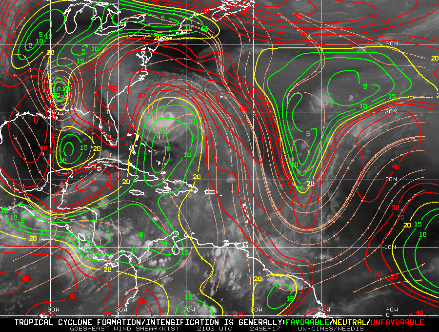
Shear is strong right over the convection, but weaker off to the west. https://walkercountytornadoes.files.wordpress.com/2017/09/wg8shr-1.gif

ASCAT isn't especially telling. https://walkercountytornadoes.files.wordpress.com/2017/09/wmbds75.png

Anyway, not to alarm anyone in the Florida panhandle. Seems to be moving north and towards land pretty fast where it'll just be a cluster of storms. I just thought this was an interesting feature worth glancing over throughout today whilst waiting on new info regarding our two active hurricanes :D
1 likes   
Colors of lost purpose on the canvas of irrelevance

Not a meteorologist, in fact more of an idiot than anything. You should probably check with the NHC or a local NWS office for official information.

User avatar
Ryxn
Category 1
Category 1
Posts: 314
Age: 24
Joined: Fri Sep 08, 2017 4:50 pm
Location: Toronto, Canada

Re: NE Gulf disturbance

#2 Postby Ryxn » Sun Sep 24, 2017 6:19 pm

I was curious about this too. 850mb vorticity on the rise (yellow) just south of the area of thunderstorms. http://tropic.ssec.wisc.edu/real-time/w ... m=&time=-1
0 likes   

User avatar
EquusStorm
Category 5
Category 5
Posts: 1649
Age: 33
Joined: Thu Nov 07, 2013 1:04 pm
Location: Jasper, AL
Contact:

Re: NE Gulf disturbance

#3 Postby EquusStorm » Sun Sep 24, 2017 6:29 pm

That matches well with the more upper-level rotation seen on satellite south of the heaviest convection. Landfall shortly, but if this had more time over water, this would be something on the TWO for sure.
0 likes   
Colors of lost purpose on the canvas of irrelevance

Not a meteorologist, in fact more of an idiot than anything. You should probably check with the NHC or a local NWS office for official information.

User avatar
tropicwatch
Category 5
Category 5
Posts: 3205
Age: 60
Joined: Sat Jun 02, 2007 10:01 am
Location: Panama City Florida
Contact:

Re: NE Gulf disturbance

#4 Postby tropicwatch » Sun Sep 24, 2017 6:30 pm

Looks like it will move into the panhandle around Panama City pretty quickly.
0 likes   
Tropicwatch


Agnes 72', Eloise 75, Elena 85', Kate 85', Charley 86', Florence 88', Beryl 94', Dean 95', Erin 95', Opal 95', Earl 98', Georges 98', Ivan 2004', Arlene 2005', Dennis 2005', Ida 2009' Debby 2012' Irma 2017' Michael 2018'


Return to “Talkin' Tropics”

Who is online

Users browsing this forum: cainjamin, Google Adsense [Bot], Teban54 and 65 guests