
This area looks notable to me. http://www.goes.noaa.gov/HURRLOOPS/atir.html
There's a broad area of light surface vorticity over Mexico, Belize and the BOC http://tropic.ssec.wisc.edu/real-time/w ... m=&time=-1
Wind shear is moderate to low in the NW Caribbean right and low in the BOC
Model guidance suggesting possibility for development over the next 10 days.
Area from NW Caribbean across Cuba to the Bahamas (now INVEST 99L)
Moderator: S2k Moderators
Forum rules

The posts in this forum are NOT official forecasts and should not be used as such. They are just the opinion of the poster and may or may not be backed by sound meteorological data. They are NOT endorsed by any professional institution or STORM2K. For official information, please refer to products from the National Hurricane Center and National Weather Service.
Area from NW Caribbean across Cuba to the Bahamas (now INVEST 99L)
Last edited by Ryxn on Wed Sep 27, 2017 4:25 am, edited 6 times in total.
1 likes
-
NotSparta

- Professional-Met

- Posts: 1646
- Age: 22
- Joined: Fri Aug 18, 2017 8:24 am
- Location: Naples, FL
- Contact:
Re: Disturbed Weather in the Western Caribbean
I can't trust anything I those waters, but hopefully it fizzles
1 likes
This post was probably an opinion of mine, and in no way is official. Please refer to http://www.hurricanes.gov for official tropical analysis and advisories.
My website, with lots of tropical wx graphics, including satellite and recon: http://cyclonicwx.com
My website, with lots of tropical wx graphics, including satellite and recon: http://cyclonicwx.com
-
Hypercane_Kyle

- Category 5

- Posts: 2899
- Joined: Sat Mar 07, 2015 7:58 pm
- Location: Cape Canaveral, FL
Re: Disturbed Weather in the Western Caribbean
WeatherEmperor wrote:
Here is a good look at the 12z ECMWF at 240hrs. Looks like there are competing areas of low pressure on the EPAC side and the Caribbean side?
Sent from my iPhone 7 using Tapatalk

Looks like Nicole '10
1 likes
My posts are my own personal opinion, defer to the National Hurricane Center (NHC) and other NOAA products for decision making during hurricane season.

Re: Disturbed Weather in the Western Caribbean
12z GEM ensemble also shows a 1005 mb low in the west caribbean at 240 hours.
https://www.tropicaltidbits.com/analysis/models/?model=gem-ens®ion=watl&pkg=mslpa&runtime=2017092512&fh=240
https://www.tropicaltidbits.com/analysis/models/?model=gem-ens®ion=watl&pkg=mslpa&runtime=2017092512&fh=240
1 likes

Re: Disturbed Weather in the Western Caribbean
If something were to form down there in the NW Caribbean what would be the steering currents?
1 likes
-
TheStormExpert

- Category 5
- Posts: 8487
- Age: 30
- Joined: Wed Feb 16, 2011 5:38 pm
- Location: Palm Beach Gardens, FL
Re: Disturbed Weather in Western Caribbean
boca wrote:If something were to form down there in the NW Caribbean what would be the steering currents?
Too soon to say. Anywhere from being buried into Central America to possibly missing Florida to the south and east while cutting across Cuba and the Bahamas. With high pressure being shown across the eastern U.S. I'm leaning more towards option #1.
0 likes
The following post is NOT an official forecast and should not be used as such. It is just the opinion of the poster and may or may not be backed by sound meteorological data. It is NOT endorsed by storm2k.org.
-
otowntiger
- Category 5
- Posts: 1787
- Joined: Tue Aug 31, 2004 7:06 pm
- Location: Orlando
Re: Disturbed Weather in Western Caribbean
Hypercane_Kyle wrote:WeatherEmperor wrote:https://uploads.tapatalk-cdn.com/20170925/884b2fc12fdf6ca47bc8e83fb5e67bae.png
Here is a good look at the 12z ECMWF at 240hrs. Looks like there are competing areas of low pressure on the EPAC side and the Caribbean side?
Sent from my iPhone 7 using Tapatalk
Looks like Nicole '10
with that synoptic set up something forming in that position won't be a threat the Continental US at all.
1 likes
-
otowntiger
- Category 5
- Posts: 1787
- Joined: Tue Aug 31, 2004 7:06 pm
- Location: Orlando
Re: Disturbed Weather in Western Caribbean
yep. Looks like whatever may get going down there will be moving east to west or west to east for a long while before it ever gets a chance to move poleward. Threat to the CONUS could be low, in that scenario.Frank2 wrote:The good news is the GFS also shows strong high pressure to our north during that same time....
Last edited by otowntiger on Mon Sep 25, 2017 4:11 pm, edited 1 time in total.
0 likes
Re: Disturbed Weather in Western Caribbean
12Z EPS 50 members: the most active EPS to this point
Hurricanes: 13 H (26%) vs 9, 10, 9 three prior runs; 5 of the 13 H hit W FL 10/8-10 (panhandle or SW peninsula) while 3 others are threatening out in the Gulf to hit W FL ~10/11-2. 1 of these SW FL hits later hits NC as a H. Other 5 Hs: 2 hit SC and 3 move NE offshore the SE US while a H
TS+: ~25 of 50 or ~50% vs 30%/44%/30% prior 3 runs
Primary movement: genesis W Caribbean or S GOM with initial movement NW to N followed by turn to NE into NE GOM/FL or S of FL to offshore SE US though 2 of those curve back into SC
Last edited by LarryWx on Mon Sep 25, 2017 4:03 pm, edited 1 time in total.
1 likes
Personal Forecast Disclaimer:
The posts in this forum are NOT official forecasts and should not be used as such. They are just the opinion of the poster and may or may not be backed by sound meteorological data. They are NOT endorsed by any professional institution or storm2k.org. For official information, please refer to the NHC and NWS products.
The posts in this forum are NOT official forecasts and should not be used as such. They are just the opinion of the poster and may or may not be backed by sound meteorological data. They are NOT endorsed by any professional institution or storm2k.org. For official information, please refer to the NHC and NWS products.
-
Shell Mound
- Category 5
- Posts: 2434
- Age: 31
- Joined: Thu Sep 07, 2017 3:39 pm
- Location: St. Petersburg, FL → Scandinavia
Re: Disturbed Weather in Western Caribbean
The topography of northern Colombia includes a number of perpendicularly oriented (south-to-north) valleys and passes on the northern flank of the Andes. These passes have access to the larger body of the water, the eastern Pacific, southwest of the Isthmus of Panama. So there are valleys next to mountains that adjourn the Isthmus of Panama and the eastern tropical (equatorial) Pacific. This combination of features allows low-level westerly flow to "funnel," turn, or converge northwest of Colombia, over the southern Caribbean; notice how many tropical waves tend to perk up once they reach this area. This creates a focal point for higher PWATs and low-level vorticity, which can help focus convection over the southern Caribbean; under the right circumstances, such as low shear, +VVP, and upper-level anticyclonic flow, this can lead to tropical development. Conversely, a system developing on the Pacific side, especially southeast of the Gulf of Tehuantepec, would tend to entrain drier air from the north, since it would be adjacent to the large mountains on the main Central American landmass (inclusive of Honduras, Guatemala, and El Salvador), hence most eastern-Pacific systems tend to get going close to the narrowest land bridge lying between the Pacific and the Bay of Campeche, that is, the Tehuantepec region. Thus the ECMWF's genesis of a small cyclone south of the main Central American landmass is less likely than the geographical configuration and large-scale circulation slowly spinning up a cyclone over the southern Caribbean. Thus the main circulation is likely to develop over the Caribbean, not the eastern Pacific. As is typical, models tend to overestimate how fast these late-season October systems brew over the southern Caribbean, only to later underestimate the systems' intensities once a low-level center becomes vertically stacked. Expect the process of genesis to take up the good part of a week. If conditions are conducive to development, as they have been this season and appear to be going forward, then the global dynamical models usually underestimate how fast a system can spin up, especially as predicting the coalescence of a small inner core is notoriously difficult when dealing with these slowly brewing gyrations. If a system develops over the Caribbean as seems probable, then don't expect the models to get a decent handle on the intensity until a well-defined low actually forms and consolidates. Once it does so, however, it could strengthen very quickly, as Wilma, Michelle, Mitch, and so many legendary (and lesser-known) systems have done around this time of year.
6 likes
CVW / MiamiensisWx / Shell Mound
The posts in this forum are NOT official forecasts and should not be used as such. They are just the opinion of the poster and may or may not be backed by sound meteorological data. They are NOT endorsed by any professional institution or STORM2K. For official information, please refer to products from the NHC and NWS.
-
gatorcane

- S2K Supporter

- Posts: 23499
- Age: 46
- Joined: Sun Mar 13, 2005 3:54 pm
- Location: Boca Raton, FL
Re: Disturbed Weather in Western Caribbean
LarryWx wrote:12Z EPS 50 members: the most active EPS to this point
Hurricanes: 13 H (26%) vs 9, 10, 9 three prior runs; 5 of the 13 H hit W FL 10/8-10 (panhandle or SW peninsula) while 3 others are threatening out in the Gulf to hit W FL ~10/11-2. 1 of these SW FL hits later hits NC as a H. Other 5 Hs: 2 hit SC and 3 move NE offshore the SE US while a H
TS+: ~25 of 50 or ~50% vs 30%/44%/30% prior 3 runs
Primary movement: genesis W Caribbean or S GOM with initial movement NW to N followed by turn to NE into NE GOM/FL or S of FL to offshore SE US though 2 of those curve back into SC
Looks like the EPS consensus shows a break in the 500MB ridge over the EGOM/Florida/Bahamas and is the reason why primary movement is NW to N then NE. Pretty typical of an October track. The GFS operational shows a similar break also.

2 likes

Re: Disturbed Weather in Western Caribbean
There would be a two or three day period next week where the storm wouldn't be able to move north. After that, it would support your usual October track northward. Are we really saying a potential TC forming in 8 to 12 days won't be a US threat? So much for learning lessons from Irma.
7 likes
Re: Disturbed Weather in Western Caribbean
boca wrote:If something were to form down there in the NW Caribbean what would be the steering currents?
The 12Z EPS says that ~80% of the 25 members that become a TS+ hit the CONUS from the Gulf (centered on FL from Panhandle south to south tip/Keys) while most of the other 20% slip just SE of S FL while moving NE. I saw virtually none that went west and got buried in Central America.
Edit: highest threat period 10/6-12. So, we may be following this potential threat for quite a long time should it materialize.
1 likes
Personal Forecast Disclaimer:
The posts in this forum are NOT official forecasts and should not be used as such. They are just the opinion of the poster and may or may not be backed by sound meteorological data. They are NOT endorsed by any professional institution or storm2k.org. For official information, please refer to the NHC and NWS products.
The posts in this forum are NOT official forecasts and should not be used as such. They are just the opinion of the poster and may or may not be backed by sound meteorological data. They are NOT endorsed by any professional institution or storm2k.org. For official information, please refer to the NHC and NWS products.
Re: Disturbed Weather in Western Caribbean
As has been mentioned by others, these systems are often painfully slow to coalesce but once they do they can go bananas quickly. Comparable to an individual or corporation going broke...slowly at first then all at once. a strong high to the north often results in slow and erratic motion until it moves east at which time a path to the north frequently opens. that's what typically happens in October. The northwest Caribbean has been quiet in recent years in October. We should see more activity there than we have as of late. This year may take a step toward evening the score.
1 likes
-
Dean4Storms
- S2K Supporter
- Posts: 6355
- Age: 61
- Joined: Sun Aug 31, 2003 1:01 pm
- Location: Miramar Bch. FL
Re: Disturbed Weather in Western Caribbean
12z ECM EPS was showing a 50% chance now of development of a TD in the Western Carib. Sea between the 2nd thru the 6th.
With a Ridge parked over the Eastern US it is a favored area to watch underneath for TC development especially this time of year and with the favorable ENSO conditions.
With a Ridge parked over the Eastern US it is a favored area to watch underneath for TC development especially this time of year and with the favorable ENSO conditions.
2 likes
-
hurricanehunter69
- Category 1

- Posts: 330
- Joined: Sun May 16, 2010 5:21 pm
- Location: New Orleans
Re: Disturbed Weather in the Western Caribbean
I wasn't expecting to start looking at this area for at least a week from now. So, for action already starting to flare up is obviously a bad sign. With extremely high TCHP and a significant La Nina developing....I can't help but wonder if several strong systems develop out of this region.....?
2 likes

Re: Disturbed Weather in Western Caribbean
Coming into the last month of the season and this is the time when TCs can form in the SW Carib due to the Central American Gyre (CAG).
http://www.atmos.albany.edu/student/ppa ... l_2017.pdf
http://www.slideserve.com/langer/a-clim ... ican-gyres
https://twitter.com/pppapin/status/912285918731603968
http://www.atmos.albany.edu/student/ppa ... l_2017.pdf
http://www.slideserve.com/langer/a-clim ... ican-gyres
https://twitter.com/pppapin/status/912285918731603968
2 likes
Re: Disturbed Weather in Western Caribbean
Strong 850mb vort off El Salvador and a weaker one off Belize

2 likes
-
CrazyC83
- Professional-Met
- Posts: 33393
- Joined: Tue Mar 07, 2006 11:57 pm
- Location: Deep South, for the first time!
Re: Disturbed Weather in Western Caribbean
We also must remember the western Caribbean is untouched this year so far. The heat content there is far higher than what fueled Harvey, Irma, Jose and Maria. If shear is near zero and outflow channels established, it can support a Wilma-like storm or stronger.
4 likes
-
NotSparta
- Professional-Met
- Posts: 1646
- Age: 22
- Joined: Fri Aug 18, 2017 8:24 am
- Location: Naples, FL
- Contact:
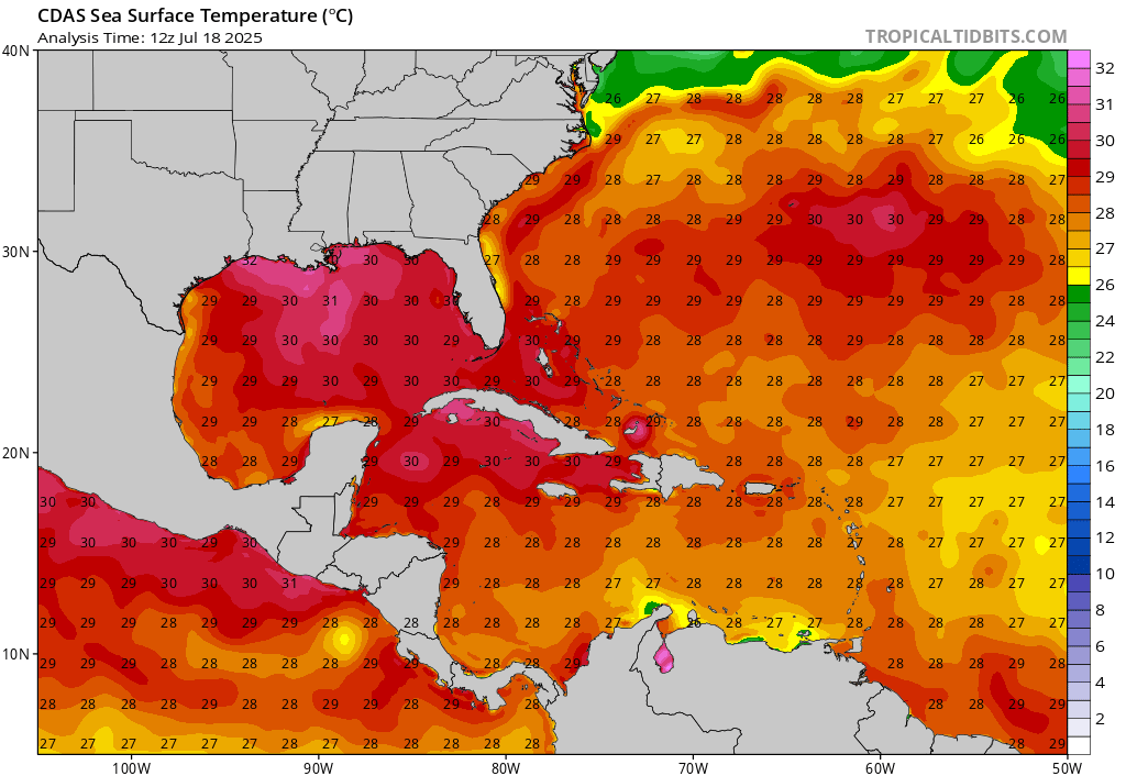
Re: Disturbed Weather in Western Caribbean
These are the bath waters that any system would have, almost reminds me of the massive warm pool in the West Pacific, just smaller:
1 likes
This post was probably an opinion of mine, and in no way is official. Please refer to http://www.hurricanes.gov for official tropical analysis and advisories.
My website, with lots of tropical wx graphics, including satellite and recon: http://cyclonicwx.com
My website, with lots of tropical wx graphics, including satellite and recon: http://cyclonicwx.com
Who is online
Users browsing this forum: Google Adsense [Bot], pavelbure224, riapal, SteveM and 117 guests