Western Caribbean disturbance - is INVEST 90L

This is the general tropical discussion area. Anyone can take their shot at predicting a storms path.

Moderator: S2k Moderators

Forum rules

The posts in this forum are NOT official forecasts and should not be used as such. They are just the opinion of the poster and may or may not be backed by sound meteorological data. They are NOT endorsed by any professional institution or STORM2K. For official information, please refer to products from the National Hurricane Center and National Weather Service.

Help Support Storm2K
Message
Author
User avatar
chris_fit
Category 5
Category 5
Posts: 3078
Joined: Wed Sep 10, 2003 11:58 pm
Location: Tampa Bay Area, FL
Contact:

Re: Western Caribbean disturbance

#141 Postby chris_fit » Tue Oct 03, 2017 11:24 am

ronjon wrote:I would think with the global model consensus NHC will bump the odds up above 30% in the 5 day now.


I agree - I'm going to go as far as say 60% within 48 hours - 80% 5 day
0 likes   

Alyono
Professional-Met
Professional-Met
Posts: 6961
Joined: Fri Apr 26, 2013 3:52 pm
Location: Texas Coast

Re: Western Caribbean disturbance

#142 Postby Alyono » Tue Oct 03, 2017 11:26 am

NEW TROPICAL CYCLONE FORECAST TO DEVELOP AFTER 114 HOURS
FORECAST POSITION AT T+114 : 27.8N 88.9W

LEAD CENTRAL MAXIMUM WIND
VERIFYING TIME TIME POSITION PRESSURE (MB) SPEED (KNOTS)
-------------- ---- -------- ------------- -------------
1200UTC 08.10.2017 120 28.6N 87.7W 999 30
0000UTC 09.10.2017 132 30.3N 86.4W 997 33
1200UTC 09.10.2017 144 32.0N 83.5W 999 32
0 likes   

psyclone
S2K Supporter
S2K Supporter
Posts: 4487
Joined: Wed Aug 24, 2005 9:04 pm
Location: palm harbor fl

Re: Western Caribbean disturbance

#143 Postby psyclone » Tue Oct 03, 2017 11:30 am

chris_fit wrote:
ronjon wrote:I would think with the global model consensus NHC will bump the odds up above 30% in the 5 day now.


I agree - I'm going to go as far as say 60% within 48 hours - 80% 5 day


With 4 forecast cycles per day they have ample time to work in no greater than 10% increments which is what they often do.
0 likes   

User avatar
Blown Away
S2K Supporter
S2K Supporter
Posts: 9861
Joined: Wed May 26, 2004 6:17 am

Re: Western Caribbean disturbance

#144 Postby Blown Away » Tue Oct 03, 2017 11:36 am

Image
12z GFS... Cat 1 near New Orleans...
0 likes   
Hurricane Eye Experience: David 79, Irene 99, Frances 04, Jeanne 04, Wilma 05...
Hurricane Brush Experience: Andrew 92, Erin 95, Floyd 99, Matthew 16, Irma 17, Ian 22, Nicole 22…

User avatar
northjaxpro
S2K Supporter
S2K Supporter
Posts: 8900
Joined: Mon Sep 27, 2010 11:21 am
Location: Jacksonville, FL

Re: Western Caribbean disturbance

#145 Postby northjaxpro » Tue Oct 03, 2017 11:38 am

12Z GFS has strong TS making landfall near New Orleans 12Z Sunday morning. We will see how later runs will fare with this.
Last edited by northjaxpro on Tue Oct 03, 2017 11:40 am, edited 1 time in total.
0 likes   
NEVER, EVER SAY NEVER in the tropics and weather in general, and most importantly, with life itself!!

________________________________________________________________________________________

Fay 2008 Beryl 2012 Debby 2012 Colin 2016 Hermine 2016 Julia 2016 Matthew 2016 Irma 2017 Dorian 2019

User avatar
Blown Away
S2K Supporter
S2K Supporter
Posts: 9861
Joined: Wed May 26, 2004 6:17 am

Re: Western Caribbean disturbance

#146 Postby Blown Away » Tue Oct 03, 2017 11:40 am

Image
00z Euro... TS/Cat 1 near Fl/Alabama line...
0 likes   
Hurricane Eye Experience: David 79, Irene 99, Frances 04, Jeanne 04, Wilma 05...
Hurricane Brush Experience: Andrew 92, Erin 95, Floyd 99, Matthew 16, Irma 17, Ian 22, Nicole 22…

User avatar
gatorcane
S2K Supporter
S2K Supporter
Posts: 23499
Age: 46
Joined: Sun Mar 13, 2005 3:54 pm
Location: Boca Raton, FL

Re: Western Caribbean disturbance

#147 Postby gatorcane » Tue Oct 03, 2017 11:41 am

DEV chances definitely going up here. For now northern Gulf coast seems the target. NAVGEM similar to the GFS and CMC.

Image
0 likes   

rickybobby
Tropical Storm
Tropical Storm
Posts: 174
Joined: Fri Sep 18, 2015 11:11 am
Location: Central Florida

Re: Western Caribbean disturbance

#148 Postby rickybobby » Tue Oct 03, 2017 11:47 am

Any chance of it coming to central Florida or to early to say?
0 likes   

User avatar
ronjon
Category 5
Category 5
Posts: 4671
Joined: Fri Aug 19, 2005 5:17 pm
Location: Hernando Beach, FL

Re: Western Caribbean disturbance

#149 Postby ronjon » Tue Oct 03, 2017 11:48 am

Of course being on the west coast of Fl north of Tampa, I'd rather be in the 4-5 day path. Think any future track adjustments might be east (hoping not). Will be glued to the model runs the next 3 days.
1 likes   

User avatar
SFLcane
S2K Supporter
S2K Supporter
Posts: 9606
Age: 46
Joined: Sat Jun 05, 2010 1:44 pm
Location: Lake Worth Florida

Re: Western Caribbean disturbance

#150 Postby SFLcane » Tue Oct 03, 2017 11:50 am

57 did mention anything that does develop will move north and northeast her didnt buy those northern solutions. Climo says Florida we shall see
0 likes   

User avatar
SoupBone
Category 5
Category 5
Posts: 3073
Joined: Tue Sep 20, 2005 5:24 pm

Re: Western Caribbean disturbance

#151 Postby SoupBone » Tue Oct 03, 2017 11:51 am

Is that 30-40kt shear supposed to hang around in the central GoM?
0 likes   
Personal Forecast Disclaimer:
The posts in this forum are NOT official forecast and should not be used as such. They are just the opinion of the poster and may or may not be backed by sound meteorological data. They are NOT endorsed by any professional institution or storm2k.org. For official information, please refer to the NHC and NWS products.

User avatar
ronjon
Category 5
Category 5
Posts: 4671
Joined: Fri Aug 19, 2005 5:17 pm
Location: Hernando Beach, FL

Re: Western Caribbean disturbance

#152 Postby ronjon » Tue Oct 03, 2017 11:52 am

SFLcane wrote:57 did mention anything that does develop will move north and northeast her didnt buy those northern solutions. Climo says Florida we shall see

Yeah SFL, climo isn't our friend in Florida this time of year.
0 likes   

User avatar
SoupBone
Category 5
Category 5
Posts: 3073
Joined: Tue Sep 20, 2005 5:24 pm

Re: Western Caribbean disturbance

#153 Postby SoupBone » Tue Oct 03, 2017 11:53 am

SFLcane wrote:57 did mention anything that does develop will move north and northeast her didnt buy those northern solutions. Climo says Florida we shall see


But some models plant a high right on top of Florida. I guess we'll see in a few days how that setup will play out.
0 likes   
Personal Forecast Disclaimer:
The posts in this forum are NOT official forecast and should not be used as such. They are just the opinion of the poster and may or may not be backed by sound meteorological data. They are NOT endorsed by any professional institution or storm2k.org. For official information, please refer to the NHC and NWS products.

USTropics
Category 5
Category 5
Posts: 2408
Joined: Sun Aug 12, 2007 3:45 am
Location: Florida State University

Re: Western Caribbean disturbance

#154 Postby USTropics » Tue Oct 03, 2017 11:53 am

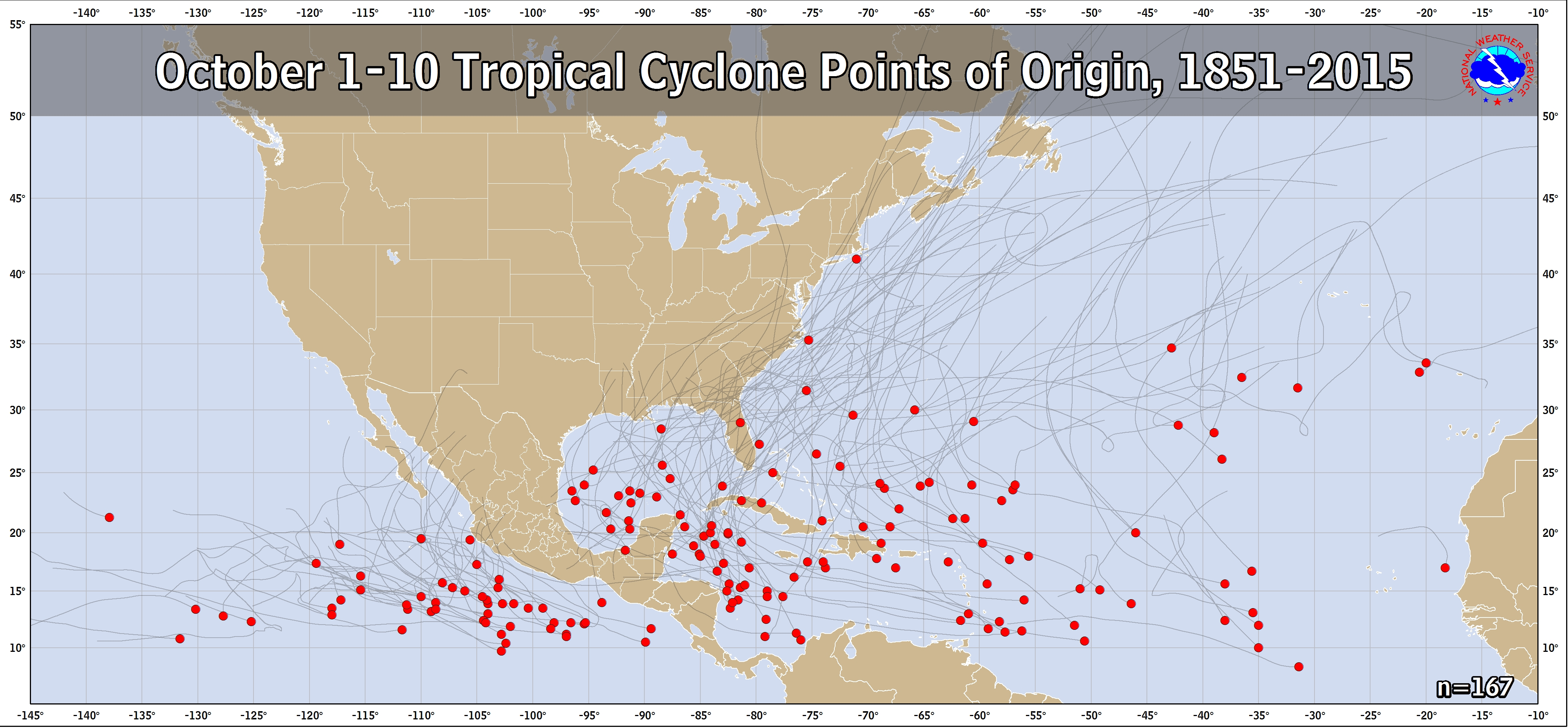
All storms that have formed since 1851 for the first 10 days of October, including their tracks (doesn't include 2016 data yet):

Image
0 likes   

User avatar
toad strangler
S2K Supporter
S2K Supporter
Posts: 4162
Joined: Sun Jul 28, 2013 3:09 pm
Location: Earth
Contact:

Re: Western Caribbean disturbance

#155 Postby toad strangler » Tue Oct 03, 2017 11:54 am

SFLcane wrote:57 did mention anything that does develop will move north and northeast her didnt buy those northern solutions. Climo says Florida we shall see


Well most likely climo tracks say FL but that region of the Gulf is certainly in the "climo cone" so to speak.
0 likes   

User avatar
ronjon
Category 5
Category 5
Posts: 4671
Joined: Fri Aug 19, 2005 5:17 pm
Location: Hernando Beach, FL

Re: Western Caribbean disturbance

#156 Postby ronjon » Tue Oct 03, 2017 11:57 am

Well lets see what king Euro says...it has the best 4-5 day model track error.
0 likes   

User avatar
chaser1
S2K Supporter
S2K Supporter
Posts: 4680
Age: 63
Joined: Sat Oct 15, 2005 5:59 pm
Location: Longwood, Fl

Re: Western Caribbean disturbance

#157 Postby chaser1 » Tue Oct 03, 2017 11:58 am

ronjon wrote:Of course being on the west coast of Fl north of Tampa, I'd rather be in the 4-5 day path. Think any future track adjustments might be east (hoping not). Will be glued to the model runs the next 3 days.


I tend to agree, though I'm thinking no further east than Cedar Key and probably Central Panhandle. As chaotic as the W. Atlantic had looked over the recent few days, and as scattered as the models have been.... i'm impressed with the appearance of the present system in the far SW Caribbean this a.m. along with the shockingly similar and logical solutions the models have for the system. I'd guess it could be classified as an invest by tomm. a.m.?
0 likes   
Personal Forecast Disclaimer:
The posts in this forum are NOT official forecast and should not be used as such. They are just the opinion of the poster and may or may not be backed by sound meteorological data. They are NOT endorsed by any professional institution or storm2k.org. For official information, please refer to the NHC and NWS products.


User avatar
toad strangler
S2K Supporter
S2K Supporter
Posts: 4162
Joined: Sun Jul 28, 2013 3:09 pm
Location: Earth
Contact:

Re: Western Caribbean disturbance

#158 Postby toad strangler » Tue Oct 03, 2017 11:59 am

ronjon wrote:Well lets see what king Euro says...it has the best 4-5 day model track error.


Euro spoke at 0z and it was West. I doubt it swings back to the E significantly.
0 likes   

User avatar
cajungal
Category 5
Category 5
Posts: 2203
Age: 47
Joined: Sun Mar 14, 2004 9:34 pm
Location: Schriever, Louisiana (60 miles southwest of New Orleans)

Re: Western Caribbean disturbance

#159 Postby cajungal » Tue Oct 03, 2017 12:01 pm

Blown Away wrote:Image
12z GFS... Cat 1 near New Orleans...


Looks like Terrebonne/Lafourche parish
0 likes   

User avatar
DESTRUCTION5
Category 5
Category 5
Posts: 4391
Age: 42
Joined: Wed Sep 03, 2003 11:25 am
Location: Stuart, FL

Re: Western Caribbean disturbance

#160 Postby DESTRUCTION5 » Tue Oct 03, 2017 12:05 pm

These tend to stay in Caribbean much longer than modeling predict sometimes. Looking like something is GOING to form Timing of when it comes out and where will make huge diff in endgame from LA to WCFL.
1 likes   
GATOR NATION IS E V E R Y W H E R E !


Return to “Talkin' Tropics”

Who is online

Users browsing this forum: Cpv17, Google Adsense [Bot] and 150 guests