2018 WPAC Season

This is the general tropical discussion area. Anyone can take their shot at predicting a storms path.

Moderator: S2k Moderators

Forum rules

The posts in this forum are NOT official forecasts and should not be used as such. They are just the opinion of the poster and may or may not be backed by sound meteorological data. They are NOT endorsed by any professional institution or STORM2K. For official information, please refer to products from the National Hurricane Center and National Weather Service.

Help Support Storm2K
Message
Author
User avatar
euro6208
Category 5
Category 5
Posts: 18547
Joined: Mon Mar 08, 2004 7:50 pm
Location: Guam

Re: 2018 WPAC Season

#421 Postby euro6208 » Fri Aug 03, 2018 8:35 am

Progression of the Kelvin Wave from the 31st to the 3rd movement towards the WPAC. MJO is nonexistant but VP200 is robust.

Image
Image
Image
Image
0 likes   
Remember, all of my post aren't official. For official warnings and discussions, Please refer to your local NWS products...

NWS for the Western Pacific

https://www.weather.gov/gum/

User avatar
euro6208
Category 5
Category 5
Posts: 18547
Joined: Mon Mar 08, 2004 7:50 pm
Location: Guam

Re: 2018 WPAC Season

#422 Postby euro6208 » Fri Aug 03, 2018 8:45 am

CFS continues to show very favorable VP anomalies throughout the rest of the month. Unbelievable.

Image
0 likes   
Remember, all of my post aren't official. For official warnings and discussions, Please refer to your local NWS products...

NWS for the Western Pacific

https://www.weather.gov/gum/

User avatar
euro6208
Category 5
Category 5
Posts: 18547
Joined: Mon Mar 08, 2004 7:50 pm
Location: Guam

Re: 2018 WPAC Season

#423 Postby euro6208 » Fri Aug 03, 2018 8:56 am

mrbagyo wrote:Why's there no mention about that system near 20N 173E?
Looks quite a bit organized to be ignored


1900hurricane wrote:Euro actually posted about it a few posts up, although I haven't looked at it much yet. ASCAT hit it earlier and still showed it as a pretty broad inverted trough still, but something could come of it.


Image
Image
Image

An area of disturbed weather has persisted near the International Date Line between Wake Island and Midway Atoll [no invest area is current for this system]. This disturbance is associated with a 1009 hPa area of low pressure and an active surface trough. Shower activity associated with the disturbance has increased in organization and coverage during the past 24 hours, although recent ASCAT and ScatSat-1/OSCAT passes do not indicate a well-defined circulation. Conditions are currently conducive for further development of this system and a tropical depression could form within the next couple of days as it moves slowly northwestward over open waters. By Monday, upper-level winds will become less favorable for development.
0 likes   
Remember, all of my post aren't official. For official warnings and discussions, Please refer to your local NWS products...

NWS for the Western Pacific

https://www.weather.gov/gum/

User avatar
euro6208
Category 5
Category 5
Posts: 18547
Joined: Mon Mar 08, 2004 7:50 pm
Location: Guam

Re: 2018 WPAC Season

#424 Postby euro6208 » Fri Aug 03, 2018 9:02 am

Very worthy of an invest. Looks better than those subtropical storms in the ATL. Possibly another unnoticed and unnamed TS in the WPAC.
0 likes   
Remember, all of my post aren't official. For official warnings and discussions, Please refer to your local NWS products...

NWS for the Western Pacific

https://www.weather.gov/gum/

User avatar
euro6208
Category 5
Category 5
Posts: 18547
Joined: Mon Mar 08, 2004 7:50 pm
Location: Guam

Re: 2018 WPAC Season

#425 Postby euro6208 » Fri Aug 03, 2018 9:05 am

95W THREAD

Finally an invest.
0 likes   
Remember, all of my post aren't official. For official warnings and discussions, Please refer to your local NWS products...

NWS for the Western Pacific

https://www.weather.gov/gum/

User avatar
euro6208
Category 5
Category 5
Posts: 18547
Joined: Mon Mar 08, 2004 7:50 pm
Location: Guam

Re: 2018 WPAC Season

#426 Postby euro6208 » Sat Aug 04, 2018 5:48 am

SCS system up.

96W THREAD
0 likes   
Remember, all of my post aren't official. For official warnings and discussions, Please refer to your local NWS products...

NWS for the Western Pacific

https://www.weather.gov/gum/

User avatar
1900hurricane
Category 5
Category 5
Posts: 6044
Age: 32
Joined: Fri Feb 06, 2015 12:04 pm
Location: Houston, TX
Contact:

Re: 2018 WPAC Season

#427 Postby 1900hurricane » Sun Aug 05, 2018 9:28 am

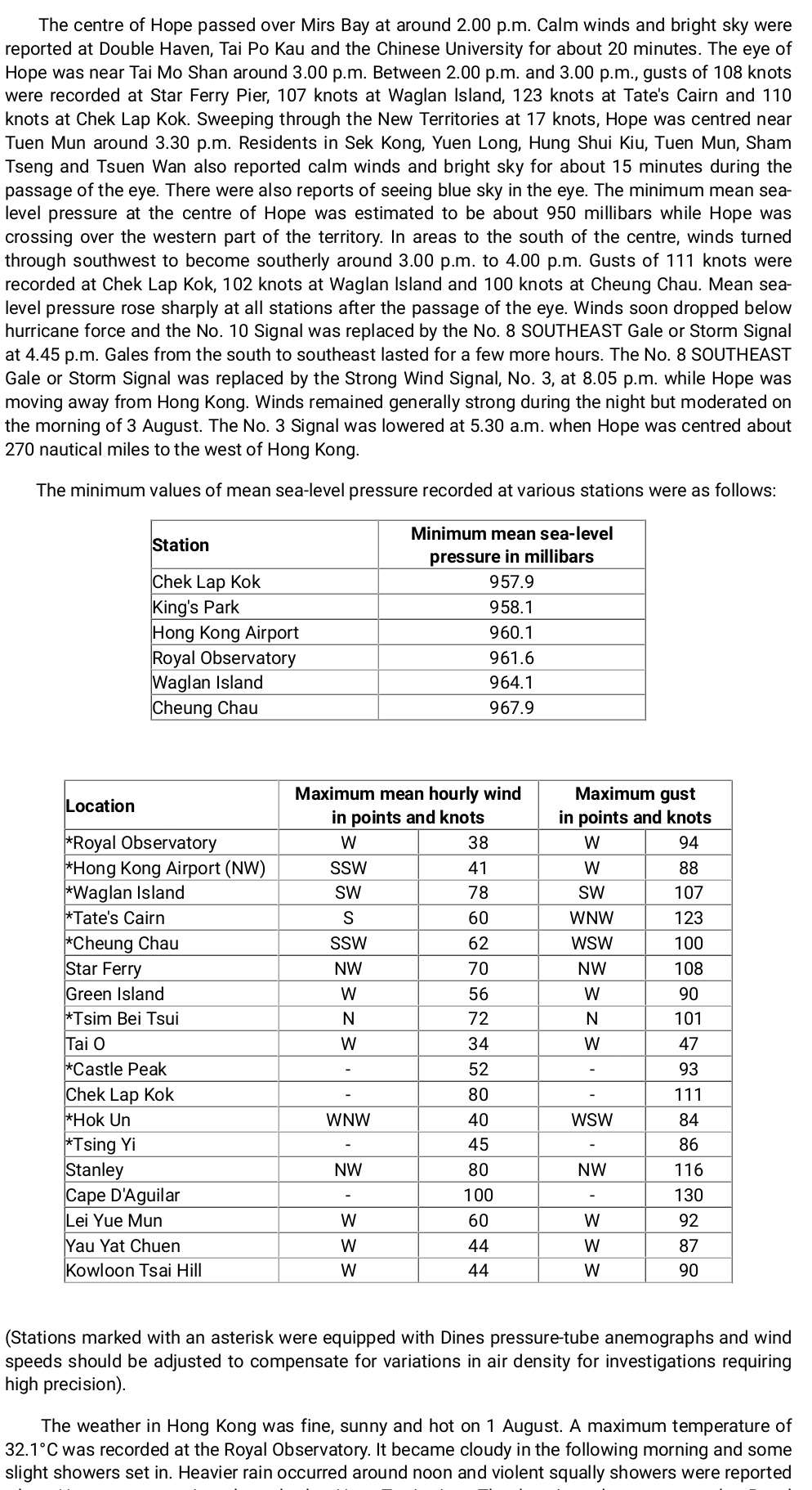
NotoSans wrote:39 years ago, the center of Typhoon Hope made landfall over the northeastern part of Hong Kong. It's one of the most severe typhoons affecting the region, and below are some photos showing the damages brought by this monster.

[images removed]

As part of my uofficial 1979 Typhoon Season reanalysis, I analyzed Hope's landfall at 105 kt/940 mb, although I did not use any land data with this analysis. I'm curious if any pressure readings in particular exist at or near the landfall point which I can use to refine my estimate.
0 likes   
Contract Meteorologist. TAMU & MSST. Fiercely authentic, one of a kind. We are all given free will, so choose a life meant to be lived. We are the Masters of our own Stories.
Opinions expressed are mine alone.

Follow me on Twitter at @1900hurricane : Read blogs at https://1900hurricane.wordpress.com/

User avatar
1900hurricane
Category 5
Category 5
Posts: 6044
Age: 32
Joined: Fri Feb 06, 2015 12:04 pm
Location: Houston, TX
Contact:

Re: 2018 WPAC Season

#428 Postby 1900hurricane » Sun Aug 05, 2018 8:23 pm

1900hurricane wrote:I'm thinking it's about a coin flip that Hector ends up entering the WPac.

Probably a bit more than a coin flip now.
0 likes   
Contract Meteorologist. TAMU & MSST. Fiercely authentic, one of a kind. We are all given free will, so choose a life meant to be lived. We are the Masters of our own Stories.
Opinions expressed are mine alone.

Follow me on Twitter at @1900hurricane : Read blogs at https://1900hurricane.wordpress.com/

NotoSans
Category 5
Category 5
Posts: 1366
Age: 24
Joined: Sun Sep 27, 2015 1:15 am
Location: Hong Kong
Contact:

Re: 2018 WPAC Season

#429 Postby NotoSans » Mon Aug 06, 2018 12:22 am

1900hurricane wrote:
NotoSans wrote:39 years ago, the center of Typhoon Hope made landfall over the northeastern part of Hong Kong. It's one of the most severe typhoons affecting the region, and below are some photos showing the damages brought by this monster.

[images removed]

As part of my uofficial 1979 Typhoon Season reanalysis, I analyzed Hope's landfall at 105 kt/940 mb, although I did not use any land data with this analysis. I'm curious if any pressure readings in particular exist at or near the landfall point which I can use to refine my estimate.


Lowest SLP recorded in Hong Kong should be around 957 mb but that’s the western part of Hong Kong and not in the center. Landfall pressure most likely is between 945 and 950 mb.
1 likes   
Personal Forecast Disclaimer:
The posts in this forum are NOT official forecast and should not be used as such. They are just the opinion of the poster and may or may not be backed by sound meteorological data. They are NOT endorsed by any professional institution or storm2k.org. For official information, please refer to RSMC and NWS products.

User avatar
euro6208
Category 5
Category 5
Posts: 18547
Joined: Mon Mar 08, 2004 7:50 pm
Location: Guam

Re: 2018 WPAC Season

#430 Postby euro6208 » Mon Aug 06, 2018 6:12 am

Image
Image
0 likes   
Remember, all of my post aren't official. For official warnings and discussions, Please refer to your local NWS products...

NWS for the Western Pacific

https://www.weather.gov/gum/

User avatar
euro6208
Category 5
Category 5
Posts: 18547
Joined: Mon Mar 08, 2004 7:50 pm
Location: Guam

Re: 2018 WPAC Season

#431 Postby euro6208 » Mon Aug 06, 2018 6:17 am

Kelvin wave moving through with the dry phrase of the MJO locked in place.

Image
Image
0 likes   
Remember, all of my post aren't official. For official warnings and discussions, Please refer to your local NWS products...

NWS for the Western Pacific

https://www.weather.gov/gum/

User avatar
euro6208
Category 5
Category 5
Posts: 18547
Joined: Mon Mar 08, 2004 7:50 pm
Location: Guam

Re: 2018 WPAC Season

#432 Postby euro6208 » Mon Aug 06, 2018 6:59 am

Models still saying more activity to continue.
0 likes   
Remember, all of my post aren't official. For official warnings and discussions, Please refer to your local NWS products...

NWS for the Western Pacific

https://www.weather.gov/gum/

User avatar
mrbagyo
Category 5
Category 5
Posts: 3614
Age: 31
Joined: Thu Apr 12, 2012 9:18 am
Location: 14.13N 120.98E
Contact:

Re: 2018 WPAC Season

#433 Postby mrbagyo » Mon Aug 06, 2018 10:23 am

1900hurricane wrote:
NotoSans wrote:39 years ago, the center of Typhoon Hope made landfall over the northeastern part of Hong Kong. It's one of the most severe typhoons affecting the region, and below are some photos showing the damages brought by this monster.

[images removed]

As part of my uofficial 1979 Typhoon Season reanalysis, I analyzed Hope's landfall at 105 kt/940 mb, although I did not use any land data with this analysis. I'm curious if any pressure readings in particular exist at or near the landfall point which I can use to refine my estimate.


HKO is a treasure trove of historical facts about typhoons - especially those that affected their locality.

Image
1 likes   
The posts in this forum are NOT official forecast and should not be used as such. They are just the opinion of the poster and may or may not be backed by sound meteorological data. They are NOT endorsed by any professional institution or storm2k.org. For official information, please refer to RSMC, NHC and NWS products.

User avatar
euro6208
Category 5
Category 5
Posts: 18547
Joined: Mon Mar 08, 2004 7:50 pm
Location: Guam

Re: 2018 WPAC Season

#434 Postby euro6208 » Wed Aug 08, 2018 6:33 am

Models quite high on more development down the road.
0 likes   
Remember, all of my post aren't official. For official warnings and discussions, Please refer to your local NWS products...

NWS for the Western Pacific

https://www.weather.gov/gum/

User avatar
euro6208
Category 5
Category 5
Posts: 18547
Joined: Mon Mar 08, 2004 7:50 pm
Location: Guam

Re: 2018 WPAC Season

#435 Postby euro6208 » Wed Aug 08, 2018 6:38 am

Image

The large-scale global tropical pattern has been fairly stationary over the past week, reflecting conditions similar to a West Pacific intraseasonal event. Widespread convection continues across East and Southeast Asia and across the Pacific, and propagation has had more of a northward component than an eastward one. The RMM-based MJO index has been somewhat erratic, but has remained outside of the unit circle over the past few days in Phases 6 or 7. The CPC velocity potential based MJO index also indicates an enhanced (suppressed) convective phase over the Pacific (Western Hemisphere), which is similar to the position of the MJO during mid-July. Analyses of low-level zonal wind anomalies reflect a persistent regime of weakened trade winds across the equatorial Pacific, part of which is due to tropical cyclone activity, but may also indicate a shifting atmospheric base state towards El Nino conditions. Additionally, a robust, convectively coupled Kelvin wave is currently crossing the Maritime Continent to the West Pacific. Dynamical model MJO index forecasts generally depict weak to no MJO activity over the next two weeks. The GEFS shows a weak-amplitude signal crossing the Western Hemisphere rapidly, with an intensification over the Indian Ocean by the end of Week-2. This may be due to the Kelvin wave. The ECMWF shows no MJO activity whatsoever during the forecast period, but many ensemble members run at the monthly time scale depict a return of enhanced West Pacific activity during late August. Based on both recent observations and the dynamical model forecasts, the MJO is anticipated to remain weak during the upcoming two weeks, and a robust Western Hemisphere event transitioning to the Indian Ocean, which could yield more favorable conditions for Atlantic tropical cyclone development, seems unlikely.


During the forecast period, continued West Pacific tropical cyclone development is favored.


There are two areas of potential development over the Northwest Pacific during Week-1, one east of the Philippines, and a second area near or just east of Guam. Confidence in formation within either of these regions is low to moderate, but given the presense of a broad trough in the region, a large moderate confidence forecast shape covering both regions was included in the outlook. During Week-2, a quiet pattern is anticipated to continue over the East Pacific and Atlantic basins, while a moderate potential for tropical cyclone development across a broad portion of the Northwest Pacific in the vicinity of Guam continues.
0 likes   
Remember, all of my post aren't official. For official warnings and discussions, Please refer to your local NWS products...

NWS for the Western Pacific

https://www.weather.gov/gum/

User avatar
euro6208
Category 5
Category 5
Posts: 18547
Joined: Mon Mar 08, 2004 7:50 pm
Location: Guam

Re: 2018 WPAC Season

#436 Postby euro6208 » Wed Aug 08, 2018 6:42 am

August and final update out of the year...

TSR continues to predict the 2018 Northwest Pacific typhoon season will see activity
slightly above the 1965-2017 norm.


27...17...9...319 ACE

http://www.tropicalstormrisk.com/
1 likes   
Remember, all of my post aren't official. For official warnings and discussions, Please refer to your local NWS products...

NWS for the Western Pacific

https://www.weather.gov/gum/

User avatar
euro6208
Category 5
Category 5
Posts: 18547
Joined: Mon Mar 08, 2004 7:50 pm
Location: Guam

Re: 2018 WPAC Season

#437 Postby euro6208 » Wed Aug 08, 2018 8:42 am

Next 5 names...

Leepi
Bebinca
Rumbia
Soulik
Cimaron
0 likes   
Remember, all of my post aren't official. For official warnings and discussions, Please refer to your local NWS products...

NWS for the Western Pacific

https://www.weather.gov/gum/

User avatar
mrbagyo
Category 5
Category 5
Posts: 3614
Age: 31
Joined: Thu Apr 12, 2012 9:18 am
Location: 14.13N 120.98E
Contact:

Re: 2018 WPAC Season

#438 Postby mrbagyo » Wed Aug 08, 2018 9:28 am

euro6208 wrote:Next 5 names...

Leepi
Bebinca
Rumbia
Soulik
Cimaron


Cimaron is still up in the lineup? That monster name was used in 2oo6.
0 likes   
The posts in this forum are NOT official forecast and should not be used as such. They are just the opinion of the poster and may or may not be backed by sound meteorological data. They are NOT endorsed by any professional institution or storm2k.org. For official information, please refer to RSMC, NHC and NWS products.

User avatar
euro6208
Category 5
Category 5
Posts: 18547
Joined: Mon Mar 08, 2004 7:50 pm
Location: Guam

Re: 2018 WPAC Season

#439 Postby euro6208 » Wed Aug 08, 2018 8:01 pm

EURO with 3 more systems in the coming days.

Image
Image
0 likes   
Remember, all of my post aren't official. For official warnings and discussions, Please refer to your local NWS products...

NWS for the Western Pacific

https://www.weather.gov/gum/

User avatar
euro6208
Category 5
Category 5
Posts: 18547
Joined: Mon Mar 08, 2004 7:50 pm
Location: Guam

Re: 2018 WPAC Season

#440 Postby euro6208 » Wed Aug 08, 2018 8:06 pm

GFS seems to agree on the first 2 systems.
0 likes   
Remember, all of my post aren't official. For official warnings and discussions, Please refer to your local NWS products...

NWS for the Western Pacific

https://www.weather.gov/gum/


Return to “Talkin' Tropics”

Who is online

Users browsing this forum: shah83 and 137 guests