Tropical Cyclone-Related Anniversaries [Five-year Intervals Only]

This is the general tropical discussion area. Anyone can take their shot at predicting a storms path.

Moderator: S2k Moderators

Forum rules

The posts in this forum are NOT official forecasts and should not be used as such. They are just the opinion of the poster and may or may not be backed by sound meteorological data. They are NOT endorsed by any professional institution or STORM2K. For official information, please refer to products from the National Hurricane Center and National Weather Service.

Help Support Storm2K
Message
Author
User avatar
Ed_2001
Tropical Storm
Tropical Storm
Posts: 228
Age: 22
Joined: Wed Jun 21, 2017 11:39 pm
Location: Santa Barbara, CA>>Tampa, FL

Re: Tropical Cyclone-Related Anniversaries [Five-year Intervals Only]

#101 Postby Ed_2001 » Sat Aug 08, 2020 4:06 am

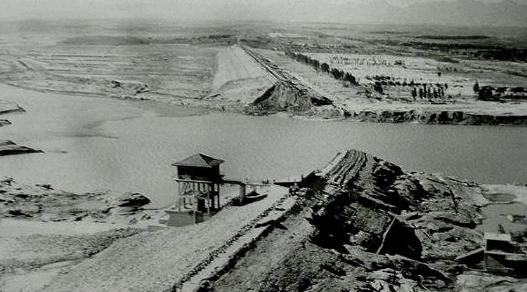
45 years ago today, The remnants of typhoon Nina produced an localized area of extreme rainfall over China's Henan province, causing 62 dams to fail. 1631mm (64.1 inches) of rain fell on Banqiao dam reservior over the course of the event including, reportedly, 33 inches (838mm) in 6 hours. The dam collapsed and inudated 3 million acres (12040 sq km) of land downstream. Very little information on the disaster was available at that time, but as many as 230,000 people perished in the flood and subsequent famine and epidemic. Nina remains to date the fourth deadliest tropical cyclone in world history and the second deadliest in the Western Pacific, after the Haiphong typhoon of 1881.

Image
Image
Image
Image
4 likes   
The answer my friend, is blowing in the wind...

Frank2
Category 5
Category 5
Posts: 4061
Joined: Mon Jul 25, 2005 12:47 pm

Re: Tropical Cyclone-Related Anniversaries [Five-year Intervals Only]

#102 Postby Frank2 » Tue Aug 25, 2020 4:30 pm

We're approaching the 60th anniversary of Hurricane Donna (1960), and a few days after it struck Florida a Miami television station's "weatherman" interviewed then-NHC Director Dr. Gordon Dunn, who gave a very low-tech but interesting explanation of the hurricane's long and destructive trek:

https://www.youtube.com/watch?v=kiQPzzy-NTg

A second Miami television station put together their own post-Donna coverage:

https://www.youtube.com/watch?v=DeTl8xK2ur8

Dr. Dunn retired in 1967 but still liked to visit us a few times each week through the 1980s, just to check the weather. He passed away in 1994.

Frank
5 likes   

supercane4867
Category 5
Category 5
Posts: 4966
Joined: Wed Nov 14, 2012 10:43 am

Re: Tropical Cyclone-Related Anniversaries [Five-year Intervals Only]

#103 Postby supercane4867 » Fri Aug 28, 2020 8:19 pm

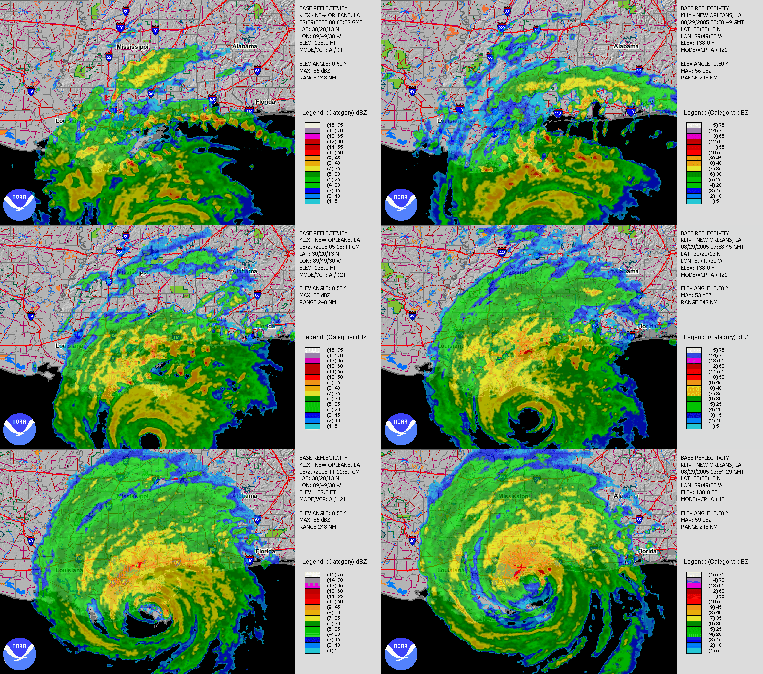
On this day 15 years ago. The evening of August 28th 2005

Image
12 likes   

MarioProtVI
Category 2
Category 2
Posts: 669
Age: 22
Joined: Sun Sep 29, 2019 7:33 pm
Location: New Jersey

Re: Tropical Cyclone-Related Anniversaries [Five-year Intervals Only]

#104 Postby MarioProtVI » Sat Aug 29, 2020 9:34 am

:uarrow: On this day in 2005, Hurricane Katrina made landfall in southeastern Louisiana at 11:10 UTC (6:10 a.m. CDT) as a high-end Category 3 hurricane with winds of 125 mph and a pressure of 920 mb after having peaked as a Category 5. It caused catastrophic damage especially in New Orleans, where the levees failed, resulting in over 1,500 deaths and a staggering damage cost of $125 billion.

Image
7 likes   

SconnieCane
Category 4
Category 4
Posts: 913
Joined: Thu Aug 02, 2018 5:29 pm
Location: Madison, WI

Re: Tropical Cyclone-Related Anniversaries [Five-year Intervals Only]

#105 Postby SconnieCane » Sat Aug 29, 2020 9:46 pm

:uarrow: It didn't help reduce the surge any, but in the above loop it is clear how much the back half of Katrina's eyewall had degraded by time of landfall (much more so than Laura's despite the lower reflectivity on LCH before it was knocked out). The same was true for Ivan, in fact in my opinion the numerous landfalls of the 2004-'05 seasons likely contributed to the popular perception that strong major hurricanes "always" weaken on approach to the northern Gulf Coast.
4 likes   

User avatar
mrbagyo
Category 5
Category 5
Posts: 3614
Age: 31
Joined: Thu Apr 12, 2012 9:18 am
Location: 14.13N 120.98E
Contact:

Re: Tropical Cyclone-Related Anniversaries [Five-year Intervals Only]

#106 Postby mrbagyo » Fri Sep 25, 2020 6:37 am

At 7:37 PM, exactly 115 years ago - Steamer S.S. Pathfinder anchored in San Policarpo Bay, Philippines recorded a minimum barometric pressure of 920.08 hPa during the passage of "The Cantabria Cyclone"

Image
8 likes   
The posts in this forum are NOT official forecast and should not be used as such. They are just the opinion of the poster and may or may not be backed by sound meteorological data. They are NOT endorsed by any professional institution or storm2k.org. For official information, please refer to RSMC, NHC and NWS products.

SconnieCane
Category 4
Category 4
Posts: 913
Joined: Thu Aug 02, 2018 5:29 pm
Location: Madison, WI

Re: Tropical Cyclone-Related Anniversaries [Five-year Intervals Only]

#107 Postby SconnieCane » Fri Sep 25, 2020 7:49 am

We missed by a day the 15-year anniversary of Hurricane Rita's landfall, which was nearly duplicated by Laura this year (slightly further east, and much stronger although without the sub-900mb Cat. 5 open-Gulf peak).

Rita at peak also had a gorgeous satellite presentation which I personally think was more impressive than either Katrina or Wilma.

https://en.wikipedia.org/wiki/Hurricane ... _1915Z.jpg
5 likes   

User avatar
1900hurricane
Category 5
Category 5
Posts: 6044
Age: 32
Joined: Fri Feb 06, 2015 12:04 pm
Location: Houston, TX
Contact:

Re: Tropical Cyclone-Related Anniversaries [Five-year Intervals Only]

#108 Postby 1900hurricane » Sun Oct 04, 2020 2:26 pm

4 likes   
Contract Meteorologist. TAMU & MSST. Fiercely authentic, one of a kind. We are all given free will, so choose a life meant to be lived. We are the Masters of our own Stories.
Opinions expressed are mine alone.

Follow me on Twitter at @1900hurricane : Read blogs at https://1900hurricane.wordpress.com/

User avatar
doomhaMwx
Category 5
Category 5
Posts: 2398
Age: 25
Joined: Tue Apr 18, 2017 4:01 am
Location: Baguio/Benguet, Philippines
Contact:

Re: Tropical Cyclone-Related Anniversaries [Five-year Intervals Only]

#109 Postby doomhaMwx » Sun Oct 18, 2020 4:37 am

This week features the anniversary of some very intense TCs in recent history, 5 yrs apart. Atlantic's Wilma('05) peaking @ 160kts 882mb, STY Megi('10) hitting Luzon @ peak of 160kts 885mb, and EPac's Patricia('15) @ record 185kts 872mb! All had recon aircraft flown into them.

Image
5 likes   
Like my content? Consider giving a tip.

User avatar
euro6208
Category 5
Category 5
Posts: 18547
Joined: Mon Mar 08, 2004 7:50 pm
Location: Guam

Re: Tropical Cyclone-Related Anniversaries [Five-year Intervals Only]

#110 Postby euro6208 » Sun Oct 18, 2020 10:02 am

Imran_doomhaMwx wrote:This week features the anniversary of some very intense TCs in recent history, 5 yrs apart. Atlantic's Wilma('05) peaking @ 160kts 882mb, STY Megi('10) hitting Luzon @ peak of 160kts 885mb, and EPac's Patricia('15) @ record 185kts 872mb! All had recon aircraft flown into them.


Kinda sad that Wilma and Patricia had regular recon missions but Megi didn't.

Recon found 175 knots or 200 mph in a research mission. Evidence that cannot be ignored. Peaked in between missions!

Also Patricia is the loner from the EPAC because of recon. :lol:

Regular WPAC recon stopped in 1987.

As they penetrated Megi's eyewall, the Hurricane Hunters performed the standard practice of maintaining a constant "pressure altitude"--the altitude one would expect to find a 700 mb pressure at in an atmosphere at standard conditions. In order to maintain a constant pressure altitude of 10,000 feet, the aircraft was forced to descend 3,000 feet in altitude as it entered Megi's eye. The aircraft entered the eye at 7,000 feet, so the pressure in Megi's eye was what one would normally find at an altitude 3,000 feet higher in the atmosphere. The aircraft recorded a remarkable increase in temperature of 12°C (22°F) as it crossed from the eyewall into the warm eye of Megi. A 12°C rise in eye temperature is extraordinarily rare in a tropical cyclone. Equally noteworthy were Megi's winds. The Hurricane Hunters measured winds at flight level of 220 mph, which normally translates to a surface wind speed of 198 mph, using the standard 10% reduction. The SFMR surface wind measurement instrument recorded surface winds of 186 mph in regions where heavy rain was not contaminating the measurement, but found surface winds of 199 mph in one region of heavy rain. Now, this measurement is considered contaminated by rain, but at very high wind speeds, the contamination effect is less important than at lower hurricane wind speeds, and it is possible than Megi's surface winds reached sustained speeds of 200 mph.
0 likes   
Remember, all of my post aren't official. For official warnings and discussions, Please refer to your local NWS products...

NWS for the Western Pacific

https://www.weather.gov/gum/

NotoSans
Category 5
Category 5
Posts: 1366
Age: 24
Joined: Sun Sep 27, 2015 1:15 am
Location: Hong Kong
Contact:

Re: Tropical Cyclone-Related Anniversaries [Five-year Intervals Only]

#111 Postby NotoSans » Sun Oct 18, 2020 11:31 am

For Wilma, Patricia and Megi, recon passes were all at 12-hour intervals near the peak.
4 likes   
Personal Forecast Disclaimer:
The posts in this forum are NOT official forecast and should not be used as such. They are just the opinion of the poster and may or may not be backed by sound meteorological data. They are NOT endorsed by any professional institution or storm2k.org. For official information, please refer to RSMC and NWS products.

User avatar
TheStormExpert
Category 5
Category 5
Posts: 8487
Age: 30
Joined: Wed Feb 16, 2011 5:38 pm
Location: Palm Beach Gardens, FL

Re: Tropical Cyclone-Related Anniversaries [Five-year Intervals Only]

#112 Postby TheStormExpert » Mon Oct 19, 2020 8:22 am

On this day in 2005, Hurricane Wilma became the strongest known Atlantic hurricane pressure-wise with a pinhole eye.

 https://twitter.com/collingrosswx/status/1318174588921122816


5 likes   
The following post is NOT an official forecast and should not be used as such. It is just the opinion of the poster and may or may not be backed by sound meteorological data. It is NOT endorsed by storm2k.org.

User avatar
1900hurricane
Category 5
Category 5
Posts: 6044
Age: 32
Joined: Fri Feb 06, 2015 12:04 pm
Location: Houston, TX
Contact:

Re: Tropical Cyclone-Related Anniversaries [Five-year Intervals Only]

#113 Postby 1900hurricane » Mon Oct 19, 2020 1:08 pm

2 likes   
Contract Meteorologist. TAMU & MSST. Fiercely authentic, one of a kind. We are all given free will, so choose a life meant to be lived. We are the Masters of our own Stories.
Opinions expressed are mine alone.

Follow me on Twitter at @1900hurricane : Read blogs at https://1900hurricane.wordpress.com/

Shell Mound
Category 5
Category 5
Posts: 2434
Age: 31
Joined: Thu Sep 07, 2017 3:39 pm
Location: St. Petersburg, FL → Scandinavia

Re: Tropical Cyclone-Related Anniversaries [Five-year Intervals Only]

#114 Postby Shell Mound » Tue Oct 20, 2020 11:14 am

2 likes   
CVW / MiamiensisWx / Shell Mound
The posts in this forum are NOT official forecasts and should not be used as such. They are just the opinion of the poster and may or may not be backed by sound meteorological data. They are NOT endorsed by any professional institution or STORM2K. For official information, please refer to products from the NHC and NWS.

User avatar
ElectricStorm
Category 5
Category 5
Posts: 4523
Age: 23
Joined: Tue Aug 13, 2019 11:23 pm
Location: Skiatook, OK / Norman, OK

Re: Tropical Cyclone-Related Anniversaries [Five-year Intervals Only]

#115 Postby ElectricStorm » Fri Oct 23, 2020 1:15 pm

Well today is the 5 year anniversary of Hurricane Patricia's record 215mph winds. Can't believe it's been 5 years already...
8 likes   
I am in no way a professional. Take what I say with a grain of salt as I could be totally wrong. Please refer to the NHC, NWS, or SPC for official information.

Boomer Sooner!

User avatar
doomhaMwx
Category 5
Category 5
Posts: 2398
Age: 25
Joined: Tue Apr 18, 2017 4:01 am
Location: Baguio/Benguet, Philippines
Contact:

Re: Tropical Cyclone-Related Anniversaries [Five-year Intervals Only]

#116 Postby doomhaMwx » Fri Oct 23, 2020 9:07 pm

From a couple of days ago...

 https://twitter.com/EdgeStorms/status/1319316448280563713


Giri's rate of intensification was incredible with the little time/space it had over the northern Bay of Bengal.

Image
0 likes   
Like my content? Consider giving a tip.

User avatar
TheStormExpert
Category 5
Category 5
Posts: 8487
Age: 30
Joined: Wed Feb 16, 2011 5:38 pm
Location: Palm Beach Gardens, FL

Re: Tropical Cyclone-Related Anniversaries [Five-year Intervals Only]

#117 Postby TheStormExpert » Sat Oct 24, 2020 6:47 am

1 likes   
The following post is NOT an official forecast and should not be used as such. It is just the opinion of the poster and may or may not be backed by sound meteorological data. It is NOT endorsed by storm2k.org.

User avatar
1900hurricane
Category 5
Category 5
Posts: 6044
Age: 32
Joined: Fri Feb 06, 2015 12:04 pm
Location: Houston, TX
Contact:

Re: Tropical Cyclone-Related Anniversaries [Five-year Intervals Only]

#118 Postby 1900hurricane » Sat Oct 24, 2020 1:13 pm

3 likes   
Contract Meteorologist. TAMU & MSST. Fiercely authentic, one of a kind. We are all given free will, so choose a life meant to be lived. We are the Masters of our own Stories.
Opinions expressed are mine alone.

Follow me on Twitter at @1900hurricane : Read blogs at https://1900hurricane.wordpress.com/

User avatar
mrbagyo
Category 5
Category 5
Posts: 3614
Age: 31
Joined: Thu Apr 12, 2012 9:18 am
Location: 14.13N 120.98E
Contact:

Re: Tropical Cyclone-Related Anniversaries [Five-year Intervals Only]

#119 Postby mrbagyo » Sat Oct 31, 2020 7:00 pm

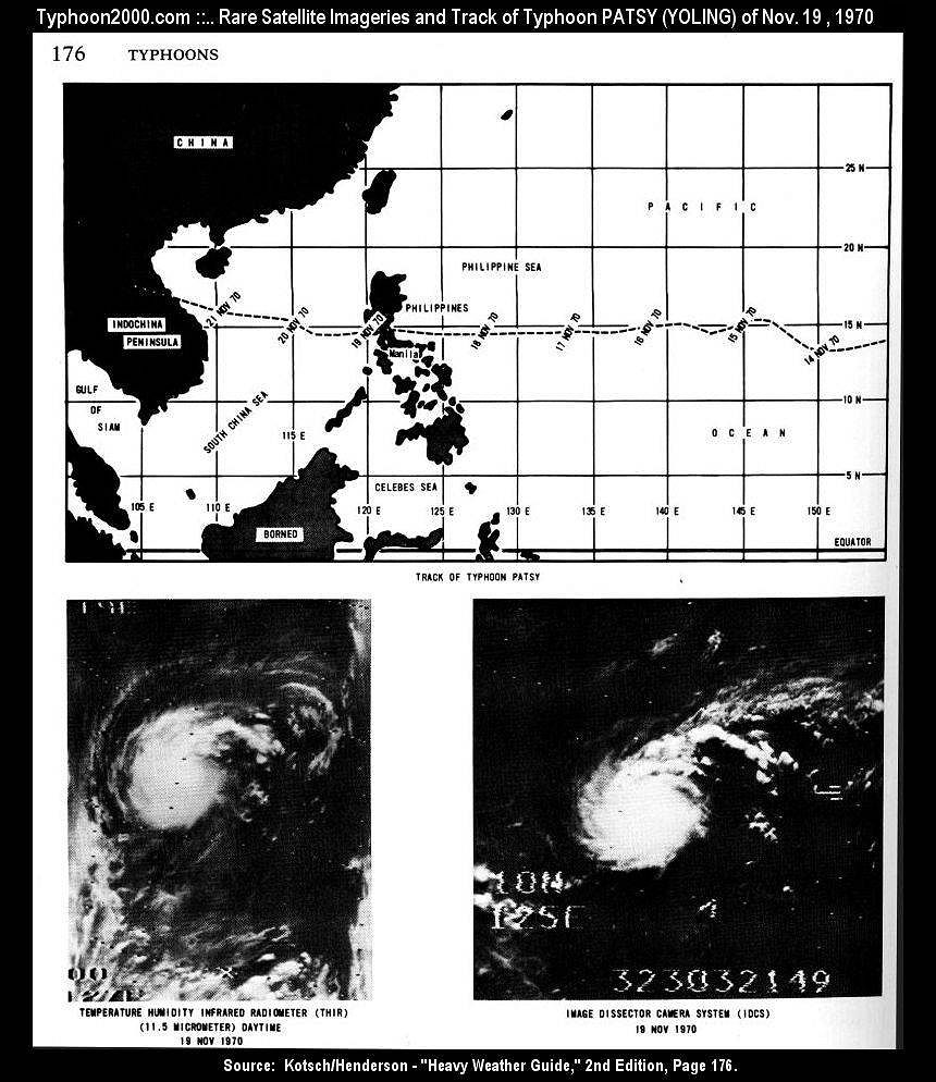
On this day, 25 years ago - Super Typhoon Angela reached her peak intensity while off the coast of Bicol region.
Now, here we are in Southern Luzon, facing a dejavu of Angela.

Same letter R designation by PAGASA
Almost the same time frame
Nearly identical track across the archipelago,
Both during La Nina condition.

Image
5 likes   
The posts in this forum are NOT official forecast and should not be used as such. They are just the opinion of the poster and may or may not be backed by sound meteorological data. They are NOT endorsed by any professional institution or storm2k.org. For official information, please refer to RSMC, NHC and NWS products.

User avatar
doomhaMwx
Category 5
Category 5
Posts: 2398
Age: 25
Joined: Tue Apr 18, 2017 4:01 am
Location: Baguio/Benguet, Philippines
Contact:

Re: Tropical Cyclone-Related Anniversaries [Five-year Intervals Only]

#120 Postby doomhaMwx » Thu Nov 19, 2020 11:27 am

1 likes   
Like my content? Consider giving a tip.


Return to “Talkin' Tropics”

Who is online

Users browsing this forum: Chris90, Google Adsense [Bot], Orlando_wx, ouragans, TheWisestofAll and 61 guests