2018 EPAC Season
Moderator: S2k Moderators
Forum rules

The posts in this forum are NOT official forecasts and should not be used as such. They are just the opinion of the poster and may or may not be backed by sound meteorological data. They are NOT endorsed by any professional institution or STORM2K. For official information, please refer to products from the National Hurricane Center and National Weather Service.

Re: 2018 EPAC Season
I think we're in for a quiet period for a little while while the Atlantic takes a turn, but I don't think the season has quieted down for good. I think by the last week of September or the first week of October things will pick up again in the EPAC. Personally, I'm expecting an October Cat 5 this year. It just feels like one of those years.
4 likes
Solar Aquarian
Lunar Cancerian
 Sagittarian
Lunar Cancerian

Re: 2018 EPAC Season
Chris90 wrote:I think we're in for a quiet period for a little while while the Atlantic takes a turn, but I don't think the season has quieted down for good. I think by the last week of September or the first week of October things will pick up again in the EPAC. Personally, I'm expecting an October Cat 5 this year. It just feels like one of those years.
The Atlantic is having a very big burst during peak of season timed well with passage of CCKW and rising motion. The behavior of the Atlantic is it can get very busy but the window tends to be short, a lot of home runs quickly during peak. Things will change once Florence/Helene are done and subsidence increases across the MDR in the basin. So I agree with you EPAC will likely pick up activity again. I would start looking off central America for something big like a Rick/Linda/Patricia breeding ground.
4 likes
The above post and any post by Ntxw is NOT an official forecast and should not be used as such. It is just the opinion of the poster and may or may not be backed by sound meteorological data. It is NOT endorsed by any professional institution including Storm2k. For official information, please refer to NWS products.
Help support Storm2K!
-
cycloneye

- Admin

- Posts: 139023
- Age: 67
- Joined: Thu Oct 10, 2002 10:54 am
- Location: San Juan, Puerto Rico
Re: 2018 EPAC Season
Ntxw,here we go with the off CentralAmerica one.

An area of low pressure is expected to develop well south of the
southwestern coast of Mexico in a few days. Some gradual
development is possible after that time while the system moves
generally westward to west-northwestward.
* Formation chance through 48 hours...low...near 0 percent.
* Formation chance through 5 days...low...20 percent.
southwestern coast of Mexico in a few days. Some gradual
development is possible after that time while the system moves
generally westward to west-northwestward.
* Formation chance through 48 hours...low...near 0 percent.
* Formation chance through 5 days...low...20 percent.
2 likes
Visit the Caribbean-Central America Weather Thread where you can find at first post web cams,radars
and observations from Caribbean basin members Click Here
and observations from Caribbean basin members Click Here
Re: 2018 EPAC Season
cycloneye wrote:Ntxw,here we go with the off CentralAmerica one.An area of low pressure is expected to develop well south of the
southwestern coast of Mexico in a few days. Some gradual
development is possible after that time while the system moves
generally westward to west-northwestward.
* Formation chance through 48 hours...low...near 0 percent.
* Formation chance through 5 days...low...20 percent.
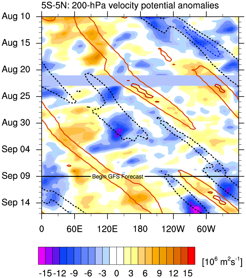
https://i.imgur.com/J9vLayg.png
I'm not sure if this is the area 0z GFS develops or maybe the one behind but it does show potential Rosa adding more ACE to the seasonal total, giving 1990 a run for the money next in line.
1 likes
The above post and any post by Ntxw is NOT an official forecast and should not be used as such. It is just the opinion of the poster and may or may not be backed by sound meteorological data. It is NOT endorsed by any professional institution including Storm2k. For official information, please refer to NWS products.
Help support Storm2K!
Help support Storm2K!
-
Kingarabian

- S2K Supporter

- Posts: 15432
- Joined: Sat Aug 08, 2009 3:06 am
- Location: Honolulu, Hawaii
-
Extratropical94

- Professional-Met

- Posts: 3535
- Age: 29
- Joined: Wed Oct 20, 2010 6:36 am
- Location: Hamburg, Germany
- Contact:
Re: 2018 EPAC Season
The area is up to 0/30.
An area of low pressure is expected to develop well south of the
southwestern coast of Mexico in a few days. Some gradual
development is possible after that time while the system moves
generally westward to west-northwestward.
* Formation chance through 48 hours...low...near 0 percent.
* Formation chance through 5 days...low...30 percent.
southwestern coast of Mexico in a few days. Some gradual
development is possible after that time while the system moves
generally westward to west-northwestward.
* Formation chance through 48 hours...low...near 0 percent.
* Formation chance through 5 days...low...30 percent.
0 likes
54° 11' 59'' N, 9° 9' 20'' E
Boomer Sooner!
Go Broncos! Go Cards! Go Niners!
- Daniel
Boomer Sooner!
Go Broncos! Go Cards! Go Niners!
- Daniel
-
cycloneye
- Admin
- Posts: 139023
- Age: 67
- Joined: Thu Oct 10, 2002 10:54 am
- Location: San Juan, Puerto Rico
Re: 2018 EPAC Season
Tropical Weather Outlook
NWS National Hurricane Center Miami FL
500 PM PDT Tue Sep 11 2018
For the eastern North Pacific...east of 140 degrees west longitude:
The National Hurricane Center is issuing advisories on Tropical
Depression Paul, located about 1000 miles west of the southern tip
of the Baja California peninsula.
1. Disorganized showers and thunderstorms extending several hundred
miles off the west-central coast of Mexico are associated with a
trough of low pressure. Recent satellite-derived wind data indicate
that the system does not have a surface circulation, and
development is not likely while it moves little during the next
couple of days.
* Formation chance through 48 hours...low...10 percent.
* Formation chance through 5 days...low...10 percent.
2. An area of low pressure is expected to develop well south of the
southwestern coast of Mexico in a few days. Some gradual
development is possible after that time while the system moves
generally westward to west-northwestward.
* Formation chance through 48 hours...low...near 0 percent.
* Formation chance through 5 days...low...30 percent.
Forecaster Berg
1 likes
Visit the Caribbean-Central America Weather Thread where you can find at first post web cams,radars
and observations from Caribbean basin members Click Here
and observations from Caribbean basin members Click Here
Re: 2018 EPAC Season
18z GFS is a very busy EPAC with passage of CCKW. If this does pan out there may be a shot at the seasonal ACE record with October and November to go. October being the season of re-curves.
1 likes
The above post and any post by Ntxw is NOT an official forecast and should not be used as such. It is just the opinion of the poster and may or may not be backed by sound meteorological data. It is NOT endorsed by any professional institution including Storm2k. For official information, please refer to NWS products.
Help support Storm2K!
Help support Storm2K!
-
Extratropical94
- Professional-Met
- Posts: 3535
- Age: 29
- Joined: Wed Oct 20, 2010 6:36 am
- Location: Hamburg, Germany
- Contact:
Re: 2018 EPAC Season
The area mentioned first in the TWO is now INVEST 93E.
Link to thread:
viewtopic.php?f=59&t=119939
The second area is up to 0%/40% as of 11am PDT.
Link to thread:
viewtopic.php?f=59&t=119939
The second area is up to 0%/40% as of 11am PDT.
2. An area of low pressure is expected to develop well south of the
southwestern coast of Mexico by the weekend. Thereafter,
environmental conditions appear conducive for some development, and
a tropical depression could form while the system moves generally
westward to west-northwestward south of Mexico.
* Formation chance through 48 hours...low...near 0 percent.
* Formation chance through 5 days...medium...40 percent.
0 likes
54° 11' 59'' N, 9° 9' 20'' E
Boomer Sooner!
Go Broncos! Go Cards! Go Niners!
- Daniel
Boomer Sooner!
Go Broncos! Go Cards! Go Niners!
- Daniel
Re: 2018 EPAC Season
18z GFS continues the idea of Rosa forming by next week. Some of the warmest waters sit off the Mexican west coast, definitely worth the watch. When stuff forms in this area post September, if atmosphere allows it, can be big hitters.
4 likes
The above post and any post by Ntxw is NOT an official forecast and should not be used as such. It is just the opinion of the poster and may or may not be backed by sound meteorological data. It is NOT endorsed by any professional institution including Storm2k. For official information, please refer to NWS products.
Help support Storm2K!
Help support Storm2K!
-
xtyphooncyclonex

- Category 5

- Posts: 3688
- Age: 22
- Joined: Sat Dec 08, 2012 9:07 am
- Location: Cebu City
- Contact:
Re: 2018 EPAC Season
Impressive season. Long-trackers that hold their intensity for long while staying away from land are ideal, I hope for more high ACE (no impact) hurricanes to come. This season has been my favorite thus far. 2014 was my first in the EPac btw.
To note, my name is just after Rosa.
To note, my name is just after Rosa.
0 likes
REMINDER: My opinions that I, or any other NON Pro-Met in this forum, are unofficial. Please do not take my opinions as an official forecast and warning. I am NOT a meteorologist. Following my forecasts blindly may lead to false alarm, danger and risk if official forecasts from agencies are ignored.
-
Extratropical94
- Professional-Met
- Posts: 3535
- Age: 29
- Joined: Wed Oct 20, 2010 6:36 am
- Location: Hamburg, Germany
- Contact:
Re: 2018 EPAC Season
Still no change
An area of low pressure is expected to develop well south of the
southwestern coast of Mexico over the weekend. Thereafter,
environmental conditions appear conducive for gradual development,
and a tropical depression could form while the system moves
generally westward to west-northwestward at 10 to 15 mph south of
Mexico.
* Formation chance through 48 hours...low...near 0 percent.
* Formation chance through 5 days...medium...40 percent.
0 likes
54° 11' 59'' N, 9° 9' 20'' E
Boomer Sooner!
Go Broncos! Go Cards! Go Niners!
- Daniel
Boomer Sooner!
Go Broncos! Go Cards! Go Niners!
- Daniel
-
cycloneye
- Admin
- Posts: 139023
- Age: 67
- Joined: Thu Oct 10, 2002 10:54 am
- Location: San Juan, Puerto Rico
Re: 2018 EPAC Season
Tropical Weather Outlook
NWS National Hurricane Center Miami FL
500 PM PDT Sat Sep 15 2018
For the eastern North Pacific...east of 140 degrees west longitude:
A large area of disturbed weather centered several hundred miles
southwest of Mexico is associated with a trough of low pressure.
Environmental conditions appear conducive for gradual development of
this system, and a tropical depression is likely to form by the
middle of next week while it moves generally northwestward at about
10 mph. Interests in Baja California Sur should monitor the
progress of this disturbance.
* Formation chance through 48 hours...low...30 percent.
* Formation chance through 5 days...high...80 percent.
$$
Forecaster Berg
0 likes
Visit the Caribbean-Central America Weather Thread where you can find at first post web cams,radars
and observations from Caribbean basin members Click Here
and observations from Caribbean basin members Click Here
-
Yellow Evan

- Professional-Met
- Posts: 15951
- Age: 25
- Joined: Fri Jul 15, 2011 12:48 pm
- Location: Henderson, Nevada/Honolulu, HI
- Contact:
Re: 2018 EPAC Season
1. A large area of disturbed weather centered several hundred miles
southwest of Mexico is associated with a trough of low pressure.
Environmental conditions appear conducive for gradual development of
this system, and a tropical depression is likely to form by the
middle of next week while it moves generally northwestward at about
10 mph. Interests in Baja California Sur should monitor the
progress of this disturbance.
* Formation chance through 48 hours...low...30 percent.
* Formation chance through 5 days...high...80 percent.
Forecaster Berg
0 likes
-
cycloneye
- Admin
- Posts: 139023
- Age: 67
- Joined: Thu Oct 10, 2002 10:54 am
- Location: San Juan, Puerto Rico
Re: 2018 EPAC Season
Tropical Weather Outlook
NWS National Hurricane Center Miami FL
1100 AM PDT Sun Sep 16 2018
For the eastern North Pacific...east of 140 degrees west longitude:
A broad and elongated area of low pressure is centered a few hundred
miles south of the southern tip of the Baja California peninsula.
Although environmental conditions appear conducive for tropical
cyclone formation, the large size of the system suggests that
development should be slow to occur. This system will likely
become a tropical depression later this week while it moves
generally northwestward at about 10 mph. Interests in Baja
California Sur should monitor the progress of this disturbance.
* Formation chance through 48 hours...low...20 percent.
* Formation chance through 5 days...high...70 percent.
A small area of low pressure located about 600 miles southwest of
the southern tip of the Baja California peninsula is producing an
area of showers and thunderstorms to the west of the center.
Significant development of this system is unlikely due to
unfavorable environmental conditions. This system is expected to
move slowly west-southwestward during the next couple of days.
* Formation chance through 48 hours...low...10 percent.
* Formation chance through 5 days...low...10 percent.
$$
Forecaster Cangialosi
0 likes
Visit the Caribbean-Central America Weather Thread where you can find at first post web cams,radars
and observations from Caribbean basin members Click Here
and observations from Caribbean basin members Click Here
-
cycloneye
- Admin
- Posts: 139023
- Age: 67
- Joined: Thu Oct 10, 2002 10:54 am
- Location: San Juan, Puerto Rico
Re: 2018 EPAC Season
Is safe to say after mid-September that the longtrackers that go west to CPAC are over and now systems form closer to Mexico and Baja?
2 likes
Visit the Caribbean-Central America Weather Thread where you can find at first post web cams,radars
and observations from Caribbean basin members Click Here
and observations from Caribbean basin members Click Here
-
cycloneye
- Admin
- Posts: 139023
- Age: 67
- Joined: Thu Oct 10, 2002 10:54 am
- Location: San Juan, Puerto Rico
Re: 2018 EPAC Season
Tropical Weather Outlook
NWS National Hurricane Center Miami FL
500 PM PDT Sun Sep 16 2018
For the eastern North Pacific...east of 140 degrees west longitude:
A broad and elongated area of low pressure centered a few hundred
miles south of the southern tip of the Baja California peninsula is
associated with widespread but disorganized showers and
thunderstorms. Although environmental conditions appear conducive
for tropical cyclone formation, the large size of the system
suggests that any development should be slow to occur. This system
will likely become a tropical depression later this week while it
moves generally northwestward or northward at about 10 mph.
Interests in Baja California Sur should monitor the progress of this
disturbance.
* Formation chance through 48 hours...low...20 percent.
* Formation chance through 5 days...high...70 percent.
A small area of low pressure located about 650 miles southwest of
the southern tip of the Baja California peninsula is producing
disorganized showers and thunderstorms. Significant development of
this system is unlikely due to unfavorable environmental
conditions. This system is expected to move slowly west-
southwestward during the next couple of days.
* Formation chance through 48 hours...low...10 percent.
* Formation chance through 5 days...low...10 percent.
$$
Forecaster Landsea
0 likes
Visit the Caribbean-Central America Weather Thread where you can find at first post web cams,radars
and observations from Caribbean basin members Click Here
and observations from Caribbean basin members Click Here
Re: 2018 EPAC Season
cycloneye wrote:Is safe to say after mid-September that the longtrackers that go west to CPAC are over and now systems form closer to Mexico and Baja?
Very likely the long west trackers are less likely. Closer to Mexico and re-curves. Though you can still get CPAC development south or southwest of Hawaii that crosses to the WPAC
2 likes
The above post and any post by Ntxw is NOT an official forecast and should not be used as such. It is just the opinion of the poster and may or may not be backed by sound meteorological data. It is NOT endorsed by any professional institution including Storm2k. For official information, please refer to NWS products.
Help support Storm2K!
Help support Storm2K!
-
cycloneye
- Admin
- Posts: 139023
- Age: 67
- Joined: Thu Oct 10, 2002 10:54 am
- Location: San Juan, Puerto Rico
Re: 2018 EPAC Season
Tropical Weather Outlook
NWS National Hurricane Center Miami FL
Issued by the NWS Weather Prediction Center College Park MD
1100 AM PDT Mon Sep 17 2018
For the eastern North Pacific...east of 140 degrees west longitude:
An elongated area of low pressure was located about 250 miles
south of the southern tip of Baja California, producing
disorganized clusters of showers and thunderstorms. Environmental
conditions appear conducive for tropical cyclone formation, although
the broad nature of the system and potential interaction with
land as it moves northward may hamper development. This system
could become a tropical depression on Wednesday or Thursday as it
approaches Baja California Sur. Regardless of development, this
system will likely produce very heavy rainfall over Baja California
Sur and other parts of northwestern Mexico later this week.
* Formation chance through 48 hours...medium...40 percent.
* Formation chance through 5 days...medium...60 percent.
$$
Forecast Burke/Blake
0 likes
Visit the Caribbean-Central America Weather Thread where you can find at first post web cams,radars
and observations from Caribbean basin members Click Here
and observations from Caribbean basin members Click Here
-
Kingarabian
- S2K Supporter
- Posts: 15432
- Joined: Sat Aug 08, 2009 3:06 am
- Location: Honolulu, Hawaii
Re: 2018 EPAC Season
cycloneye wrote:Is safe to say after mid-September that the longtrackers that go west to CPAC are over and now systems form closer to Mexico and Baja?
The classic long trackers originating near 110W and moving into the CPAC should be about done. But we could still see systems developing closer to 130-140W and moving across the CPAC. Also because it looks like El Nino will be coming on later we could still see activity past November.
2 likes
RIP Kobe Bryant