2018 EPAC Season
Moderator: S2k Moderators
Forum rules

The posts in this forum are NOT official forecasts and should not be used as such. They are just the opinion of the poster and may or may not be backed by sound meteorological data. They are NOT endorsed by any professional institution or STORM2K. For official information, please refer to products from the National Hurricane Center and National Weather Service.
-
cycloneye

- Admin

- Posts: 139008
- Age: 67
- Joined: Thu Oct 10, 2002 10:54 am
- Location: San Juan, Puerto Rico
Re: 2018 EPAC Season
0 likes
Visit the Caribbean-Central America Weather Thread where you can find at first post web cams,radars
and observations from Caribbean basin members Click Here
and observations from Caribbean basin members Click Here
-
Kingarabian

- S2K Supporter

- Posts: 15432
- Joined: Sat Aug 08, 2009 3:06 am
- Location: Honolulu, Hawaii
Re: 2018 EPAC Season
I think two more invests should be tagged soon. All models develop a system by Friday, before or after crossing 140W, and are on and off on developing the disturbance behind it by this weekend.
0 likes
RIP Kobe Bryant

Re: 2018 EPAC Season
Fuse has been lit. Rosa will make a run at cat 3/4 and the area southeast of Hawaii will move for the dateline as maybe a major also. Something may form behind Rosa. ACE collection.
3 likes
The above post and any post by Ntxw is NOT an official forecast and should not be used as such. It is just the opinion of the poster and may or may not be backed by sound meteorological data. It is NOT endorsed by any professional institution including Storm2k. For official information, please refer to NWS products.
Help support Storm2K!
-
Kingarabian
- S2K Supporter
- Posts: 15432
- Joined: Sat Aug 08, 2009 3:06 am
- Location: Honolulu, Hawaii
Re: 2018 EPAC Season
That CPAC system will likely be a real treat since it'll be developing off the monsoon trough. Hope it stays far away from Hawaii.
0 likes
RIP Kobe Bryant
-
cycloneye
- Admin
- Posts: 139008
- Age: 67
- Joined: Thu Oct 10, 2002 10:54 am
- Location: San Juan, Puerto Rico
Re: 2018 EPAC Season
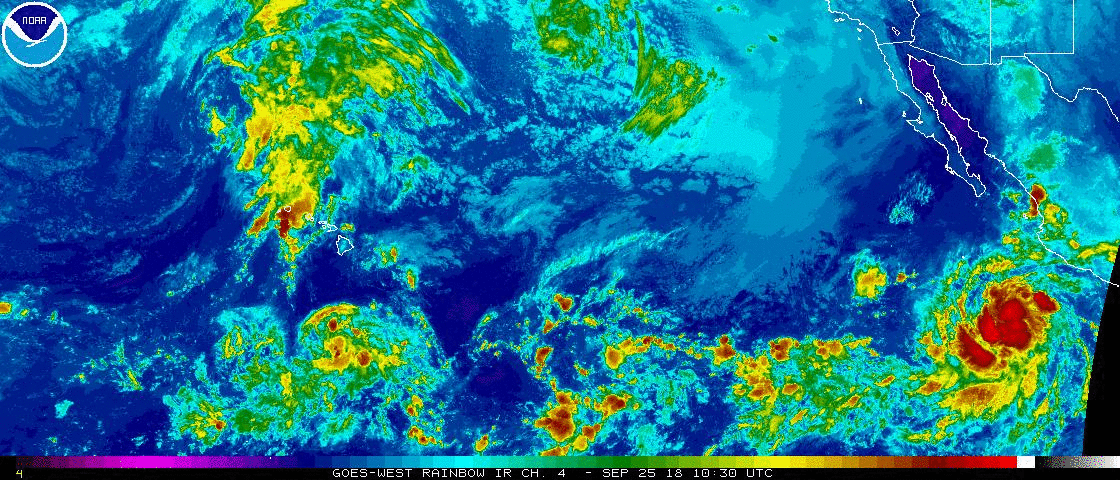
A broad area of low pressure located a few hundred miles
south-southeast of the southern coast of Mexico is producing
disorganized showers and thunderstorms. Environmental conditions
appear conducive for gradual development, and a tropical cyclone is
likely to form over the weekend or early next week while it moves
west-northwestward well offshore of the coast of Mexico.
* Formation chance through 48 hours...low...30 percent.
* Formation chance through 5 days...medium...60 percent.
0 likes
Visit the Caribbean-Central America Weather Thread where you can find at first post web cams,radars
and observations from Caribbean basin members Click Here
and observations from Caribbean basin members Click Here
-
cycloneye
- Admin
- Posts: 139008
- Age: 67
- Joined: Thu Oct 10, 2002 10:54 am
- Location: San Juan, Puerto Rico
Re: 2018 EPAC Season
Satellite data and reports from a NOAA Hurricane Hunter aircraft
indicate that the circulation associated with an area of low
pressure a few hundred miles south of the Gulf of Tehuantepec has
become a little better defined since yesterday. Environmental
conditions appear favorable for additional development, and a
tropical cyclone is likely to form over the weekend or early next
week while it moves west-northwestward well offshore of the coast of
Mexico.
* Formation chance through 48 hours...medium...50 percent.
* Formation chance through 5 days...high...80 percent.
0 likes
Visit the Caribbean-Central America Weather Thread where you can find at first post web cams,radars
and observations from Caribbean basin members Click Here
and observations from Caribbean basin members Click Here
-
cycloneye
- Admin
- Posts: 139008
- Age: 67
- Joined: Thu Oct 10, 2002 10:54 am
- Location: San Juan, Puerto Rico
Re: 2018 EPAC Season
0 likes
Visit the Caribbean-Central America Weather Thread where you can find at first post web cams,radars
and observations from Caribbean basin members Click Here
and observations from Caribbean basin members Click Here
Re: 2018 EPAC Season
Rosa will get the EPAC to near 240 units of ACE. 96E (Sergio to be) could add another 15-20 units like Rosa depending on strength. That's not including 97C before the IDL, this could get interesting as it could threaten 2015 and 1992 for the record.
3 likes
The above post and any post by Ntxw is NOT an official forecast and should not be used as such. It is just the opinion of the poster and may or may not be backed by sound meteorological data. It is NOT endorsed by any professional institution including Storm2k. For official information, please refer to NWS products.
Help support Storm2K!
Help support Storm2K!
Re: 2018 EPAC Season
Certainly helps the stat when every major (7) has made it to Cat 4 or higher.
https://twitter.com/philklotzbach/status/1045735922162192384
https://twitter.com/philklotzbach/status/1045735922162192384
2 likes
The above post and any post by Ntxw is NOT an official forecast and should not be used as such. It is just the opinion of the poster and may or may not be backed by sound meteorological data. It is NOT endorsed by any professional institution including Storm2k. For official information, please refer to NWS products.
Help support Storm2K!
Help support Storm2K!
-
hurricanes1234
- Category 5

- Posts: 2903
- Joined: Sat Jul 28, 2012 6:19 pm
- Location: Trinidad and Tobago
Re: 2018 EPAC Season
Ntxw wrote:Certainly helps the stat when every major (7) has made it to Cat 4 or higher.
https://twitter.com/philklotzbach/status/1045735922162192384
And there's quite possibly more to come, especially in the near future with 96E and 97C. I think there's a legitimate chance this season either surpasses or comes very close to the ACE record in a single season.
1 likes
PLEASE NOTE: With the exception of information from weather agencies that I may copy and paste here, my posts will NEVER be official, since I am NOT a meteorologist. They are solely my amateur opinion, and may or may not be accurate. Therefore, please DO NOT use them as official details, particularly when making important decisions. Thank you.
Re: 2018 EPAC Season
hurricanes1234 wrote:Ntxw wrote:Certainly helps the stat when every major (7) has made it to Cat 4 or higher.
https://twitter.com/philklotzbach/status/1045735922162192384
And there's quite possibly more to come, especially in the near future with 96E and 97C. I think there's a legitimate chance this season either surpasses or comes very close to the ACE record in a single season.
Going by just the currently active systems, NHC forecast could yield an addition 6-7 units for Rosa with about 11 in the books. Probably end up around 20 units for her total. Sergio might get a little more given his latitude and slower movement in his mid life so 20-25 units there is my guess. 25-30 units additional between those two in the eastern basin. 97C is a wild card, it has a really high ceiling and can pump anywhere between 20-40 units depending on strength and path before the IDL. You're looking at 40-60 units from all three. That's ~270-290 when they are done which is in range of the record.
One more additional Hurricane of consequence and the record likely breaks.
4 likes
The above post and any post by Ntxw is NOT an official forecast and should not be used as such. It is just the opinion of the poster and may or may not be backed by sound meteorological data. It is NOT endorsed by any professional institution including Storm2k. For official information, please refer to NWS products.
Help support Storm2K!
Help support Storm2K!
-
hurricanes1234
- Category 5
- Posts: 2903
- Joined: Sat Jul 28, 2012 6:19 pm
- Location: Trinidad and Tobago
Re: 2018 EPAC Season
Ntxw wrote:hurricanes1234 wrote:Ntxw wrote:Certainly helps the stat when every major (7) has made it to Cat 4 or higher.
https://twitter.com/philklotzbach/status/1045735922162192384
And there's quite possibly more to come, especially in the near future with 96E and 97C. I think there's a legitimate chance this season either surpasses or comes very close to the ACE record in a single season.
Going by just the currently active systems, NHC forecast could yield an addition 6-7 units for Rosa with about 11 in the books. Probably end up around 20 units for her total. Sergio might get a little more given his latitude and slower movement in his mid life so 20-25 units there is my guess. 25-30 units additional between those two in the eastern basin. 97C is a wild card, it has a really high ceiling and can pump anywhere between 20-40 units depending on strength and path before the IDL. You're looking at 40-60 units from all three. That's ~270-290 when they are done which is in range of the record.
One more additional Hurricane of consequence and the record likely breaks.
Agreed, because after these systems dissipate, we still have most of October and all of November to go. I would expect there to be at least one strong hurricane after that and I would be very surprised if we don't have one. Heck, if things continue at this rate into October and November, there's a chance we could even see the record of 11 major hurricanes at least almost tied as well.
3 likes
PLEASE NOTE: With the exception of information from weather agencies that I may copy and paste here, my posts will NEVER be official, since I am NOT a meteorologist. They are solely my amateur opinion, and may or may not be accurate. Therefore, please DO NOT use them as official details, particularly when making important decisions. Thank you.
Re: 2018 EPAC Season
hurricanes1234 wrote:Agreed, because after these systems dissipate, we still have most of October and all of November to go. I would expect there to be at least one strong hurricane after that and I would be very surprised if we don't have one. Heck, if things continue at this rate into October and November, there's a chance we could even see the record of 11 major hurricanes at least almost tied as well.
All this with July doing diddly squat. What a comeback it has been
3 likes
The above post and any post by Ntxw is NOT an official forecast and should not be used as such. It is just the opinion of the poster and may or may not be backed by sound meteorological data. It is NOT endorsed by any professional institution including Storm2k. For official information, please refer to NWS products.
Help support Storm2K!
Help support Storm2K!
-
EquusStorm

- Category 5
- Posts: 1649
- Age: 33
- Joined: Thu Nov 07, 2013 1:04 pm
- Location: Jasper, AL
- Contact:
Re: 2018 EPAC Season
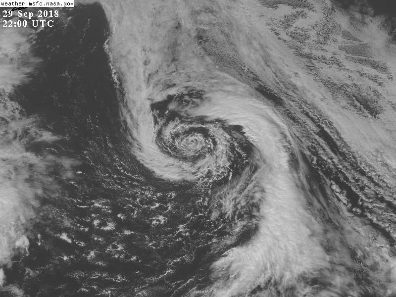
Slightly off topic but, this is a neat looking extratropical system between Oregon and the Aleutians... definitely made me do a double take for a second
4 likes
Colors of lost purpose on the canvas of irrelevance
Not a meteorologist, in fact more of an idiot than anything. You should probably check with the NHC or a local NWS office for official information.
Not a meteorologist, in fact more of an idiot than anything. You should probably check with the NHC or a local NWS office for official information.
Re: 2018 EPAC Season
EquusStorm wrote:Slightly off topic but, this is a neat looking extratropical system between Oregon and the Aleutians... definitely made me do a double take for a second
https://horsesnhurricanes.files.wordpress.com/2018/09/goes22002018272gr9lwb.jpg
There are countless of these in the North Pacific that are largely ignored, even more than they occur in the NATL. In the Atlantic they are often classified as subtropical but aren't even given a look on the other side.
Earlier in the season, ex-Lane, or the trough that picked up Lane reformed and what looked like a Hurricane south of the Aleutians, largely ignored.

4 likes
The above post and any post by Ntxw is NOT an official forecast and should not be used as such. It is just the opinion of the poster and may or may not be backed by sound meteorological data. It is NOT endorsed by any professional institution including Storm2k. For official information, please refer to NWS products.
Help support Storm2K!
Help support Storm2K!
-
EquusStorm
- Category 5
- Posts: 1649
- Age: 33
- Joined: Thu Nov 07, 2013 1:04 pm
- Location: Jasper, AL
- Contact:
Re: 2018 EPAC Season
I get the feeling that official organizations are loathe to even look into intriguing systems where they "shouldn't be" - far from historical tracks or where waters are deemed too cold for subtropical development, without taking much of the upper air environment that could possibly offset the negatives into account. Though, I guess the term subtropical is a pretty broad one.
0 likes
Colors of lost purpose on the canvas of irrelevance
Not a meteorologist, in fact more of an idiot than anything. You should probably check with the NHC or a local NWS office for official information.
Not a meteorologist, in fact more of an idiot than anything. You should probably check with the NHC or a local NWS office for official information.
Re: 2018 EPAC Season
Kind of intriguing Sergio is going to hang around for awhile and put up serious ACE. A lot more than earlier forecast.
Completely anecdotal but Olaf did something similar in 2015 albeit further west. Then rumblings of Central American Gyre and Western Carib formation over in the Atlantic but Patricia (models hardly even had her to become much of anything days before) came out of nowhere and snatched all the attention away from that Gyre. Will we see a repeat?
Completely anecdotal but Olaf did something similar in 2015 albeit further west. Then rumblings of Central American Gyre and Western Carib formation over in the Atlantic but Patricia (models hardly even had her to become much of anything days before) came out of nowhere and snatched all the attention away from that Gyre. Will we see a repeat?
1 likes
The above post and any post by Ntxw is NOT an official forecast and should not be used as such. It is just the opinion of the poster and may or may not be backed by sound meteorological data. It is NOT endorsed by any professional institution including Storm2k. For official information, please refer to NWS products.
Help support Storm2K!
Help support Storm2K!
-
Yellow Evan

- Professional-Met

- Posts: 15951
- Age: 25
- Joined: Fri Jul 15, 2011 12:48 pm
- Location: Henderson, Nevada/Honolulu, HI
- Contact:
Re: 2018 EPAC Season
Ntxw wrote:Kind of intriguing Sergio is going to hang around for awhile and put up serious ACE. A lot more than earlier forecast.
Completely anecdotal but Olaf did something similar in 2015 albeit further west. Then rumblings of Central American Gyre and Western Carib formation over in the Atlantic but Patricia (models hardly even had her to become much of anything days before) came out of nowhere and snatched all the attention away from that Gyre. Will we see a repeat?
Olaf formed much further west so the MJO/CCKW was still moving east at the time and thus was in position for a little something a few days later.
0 likes
-
Kingarabian
- S2K Supporter
- Posts: 15432
- Joined: Sat Aug 08, 2009 3:06 am
- Location: Honolulu, Hawaii
Re: 2018 EPAC Season
EPS and some GFS runs hinting at a system developing near Mexico in 15-16 days. That and possibly a hurricane in November will possibly push us towards 300 ACE.
1 likes
RIP Kobe Bryant
Re: 2018 EPAC Season
Operationally Walaka becomes the second Cat 5 of the season for the EPAC+CPAC (Hector can make a strong case post season, a reasonable case for Norman). ACE for Walaka via the CPHC 5 day forecast yields an additional 20 units on top of the 5 done. Sergio has about 2 units so far so the season is sitting around 240 units. Sergio has kind of been slow to progress so the NHC forecast yields about 10 units more through 5 days. That gets to about 270.
2 likes
The above post and any post by Ntxw is NOT an official forecast and should not be used as such. It is just the opinion of the poster and may or may not be backed by sound meteorological data. It is NOT endorsed by any professional institution including Storm2k. For official information, please refer to NWS products.
Help support Storm2K!
Help support Storm2K!
Who is online
Users browsing this forum: No registered users and 50 guests