2018 EPAC Season

This is the general tropical discussion area. Anyone can take their shot at predicting a storms path.

Moderator: S2k Moderators

Forum rules

The posts in this forum are NOT official forecasts and should not be used as such. They are just the opinion of the poster and may or may not be backed by sound meteorological data. They are NOT endorsed by any professional institution or STORM2K. For official information, please refer to products from the National Hurricane Center and National Weather Service.

Help Support Storm2K
Message
Author
User avatar
cycloneye
Admin
Admin
Posts: 139026
Age: 67
Joined: Thu Oct 10, 2002 10:54 am
Location: San Juan, Puerto Rico

Re: 2018 EPAC Season

#1161 Postby cycloneye » Wed Oct 03, 2018 6:28 pm

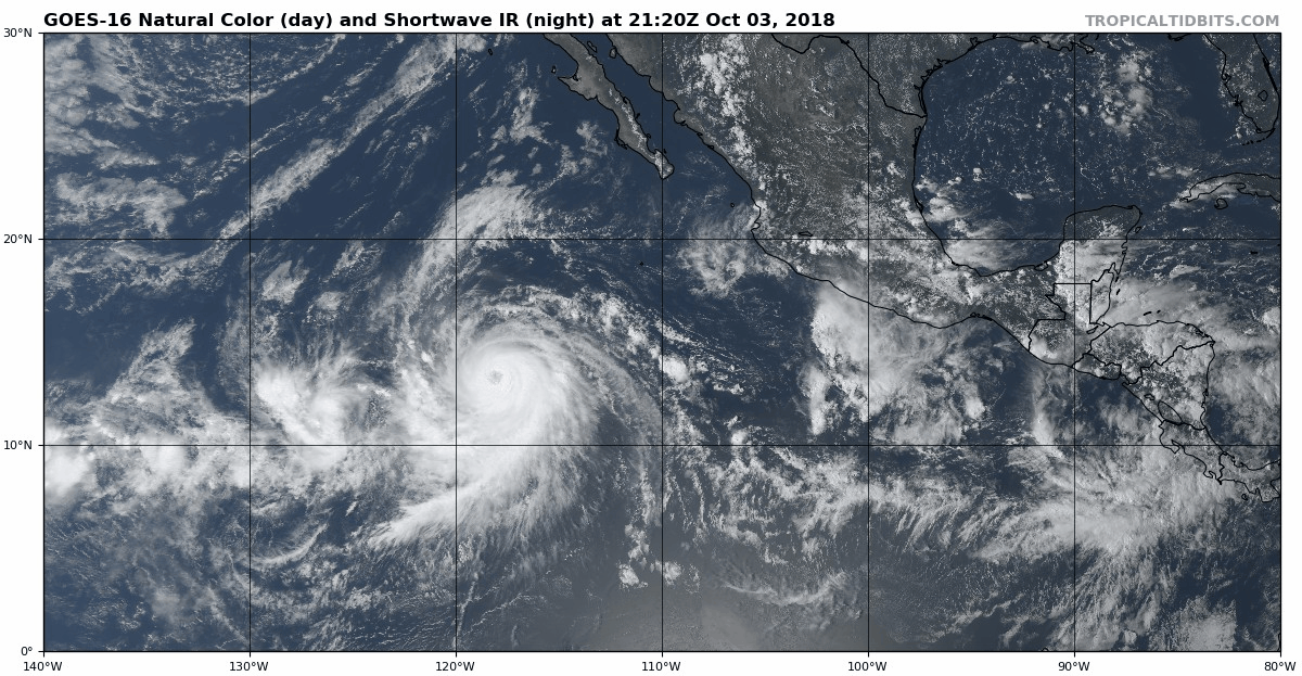
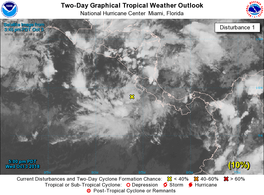
Disorganized showers and thunderstorms located just southwest of
Costa Rica are associated with a broad area of low pressure. Some
slow development of this system is possible over the next several
days as the low drifts northward and northwestward near Central
America. Regardless of development, heavy rains causing flash
floods and mudslides in mountaneous areas are possible across
western Costa Rica, Nicaragua, Honduras, El Salvador and Guatemala
through early next week.
* Formation chance through 48 hours...low...10 percent.
* Formation chance through 5 days...low...30 percent.
0 likes   
Visit the Caribbean-Central America Weather Thread where you can find at first post web cams,radars
and observations from Caribbean basin members Click Here

Ntxw
Storm2k Moderator
Storm2k Moderator
Posts: 21494
Joined: Wed Oct 21, 2009 6:34 pm
Location: DFW, Texas

Re: 2018 EPAC Season

#1162 Postby Ntxw » Wed Oct 03, 2018 7:17 pm

Image

Image
1 likes   
The above post and any post by Ntxw is NOT an official forecast and should not be used as such. It is just the opinion of the poster and may or may not be backed by sound meteorological data. It is NOT endorsed by any professional institution including Storm2k. For official information, please refer to NWS products.

  Help support Storm2K!
Help Support Storm2K

User avatar
cycloneye
Admin
Admin
Posts: 139026
Age: 67
Joined: Thu Oct 10, 2002 10:54 am
Location: San Juan, Puerto Rico

Re: 2018 EPAC Season

#1163 Postby cycloneye » Wed Oct 03, 2018 9:39 pm

What a 2018 banner season.

Sergio is the record most
8th category 4 hurricane of the 2018 eastern Pacific season-
breaking the old record of 7 set in 2015. Reliable records in the
eastern Pacific for major hurricanes go back to 1971
5 likes   
Visit the Caribbean-Central America Weather Thread where you can find at first post web cams,radars
and observations from Caribbean basin members Click Here

User avatar
Kingarabian
S2K Supporter
S2K Supporter
Posts: 15432
Joined: Sat Aug 08, 2009 3:06 am
Location: Honolulu, Hawaii

Re: 2018 EPAC Season

#1164 Postby Kingarabian » Thu Oct 04, 2018 2:15 am


Doesn't look good for Mexico. This disturbance has great curvature and a really nice structure that will enhance the chances of a strong hurricane forming and threatening the Mexican coast next week.

The posts in this forum are NOT official forecast and should not be used as such. They are just the opinion of the poster and may or may not be backed by sound meteorological data. They are NOT endorsed by any professional institution or STORM2K. For official information, please refer to products from the National Hurricane Center and National Weather Service.
0 likes   
RIP Kobe Bryant

SconnieCane
Category 4
Category 4
Posts: 913
Joined: Thu Aug 02, 2018 5:29 pm
Location: Madison, WI

Re: 2018 EPAC Season

#1165 Postby SconnieCane » Thu Oct 04, 2018 5:46 am

:uarrow: I would think there would be muchas upwelling behind Sergio, Rosa, etc or will this not be spending much time over their wakes?
0 likes   

Ntxw
Storm2k Moderator
Storm2k Moderator
Posts: 21494
Joined: Wed Oct 21, 2009 6:34 pm
Location: DFW, Texas

Re: 2018 EPAC Season

#1166 Postby Ntxw » Thu Oct 04, 2018 5:52 am

SconnieCane wrote::uarrow: I would think there would be muchas upwelling behind Sergio, Rosa, etc or will this not be spending much time over their wakes?


Neither storm sat over an area long enough to do significant upwelling. Anything that parallels the southwest Mexican coast has some of the best fuel to work with. Haven't had a significant storm parallel yet. Storms that go along that path late in the season (Patricia, Linda, Rick) can have short but intense lives.
3 likes   
The above post and any post by Ntxw is NOT an official forecast and should not be used as such. It is just the opinion of the poster and may or may not be backed by sound meteorological data. It is NOT endorsed by any professional institution including Storm2k. For official information, please refer to NWS products.


  Help support Storm2K!

Help Support Storm2K


Ntxw
Storm2k Moderator
Storm2k Moderator
Posts: 21494
Joined: Wed Oct 21, 2009 6:34 pm
Location: DFW, Texas

Re: 2018 EPAC Season

#1167 Postby Ntxw » Thu Oct 04, 2018 10:50 am

EPAC is closing in on 270 units of ACE.
3 likes   
The above post and any post by Ntxw is NOT an official forecast and should not be used as such. It is just the opinion of the poster and may or may not be backed by sound meteorological data. It is NOT endorsed by any professional institution including Storm2k. For official information, please refer to NWS products.


  Help support Storm2K!

Help Support Storm2K


User avatar
cycloneye
Admin
Admin
Posts: 139026
Age: 67
Joined: Thu Oct 10, 2002 10:54 am
Location: San Juan, Puerto Rico

Re: 2018 EPAC Season

#1168 Postby cycloneye » Thu Oct 04, 2018 6:24 pm

0 likes   
Visit the Caribbean-Central America Weather Thread where you can find at first post web cams,radars
and observations from Caribbean basin members Click Here

Ntxw
Storm2k Moderator
Storm2k Moderator
Posts: 21494
Joined: Wed Oct 21, 2009 6:34 pm
Location: DFW, Texas

Re: 2018 EPAC Season

#1169 Postby Ntxw » Fri Oct 05, 2018 9:53 am

1 likes   
The above post and any post by Ntxw is NOT an official forecast and should not be used as such. It is just the opinion of the poster and may or may not be backed by sound meteorological data. It is NOT endorsed by any professional institution including Storm2k. For official information, please refer to NWS products.


  Help support Storm2K!

Help Support Storm2K


Ntxw
Storm2k Moderator
Storm2k Moderator
Posts: 21494
Joined: Wed Oct 21, 2009 6:34 pm
Location: DFW, Texas

Re: 2018 EPAC Season

#1170 Postby Ntxw » Fri Oct 05, 2018 10:49 am

EPAC is now at 275 units. Sergio will spin with decent conditions to remain at least a Hurricane for the next 5 days via the NHC forecast. 290.6 per CSU is the record from 1992 while Wikipedia lists 295. Regardless that record looks achievable now with some room to spare for an additional system. What an incredible 2018 Northeast Pacific season east of the IDL. In particular ACE wise it has been a prolific CPAC ACE season. Bang for the buck quality wise this is as good if not better than 1994.

Image
8 likes   
The above post and any post by Ntxw is NOT an official forecast and should not be used as such. It is just the opinion of the poster and may or may not be backed by sound meteorological data. It is NOT endorsed by any professional institution including Storm2k. For official information, please refer to NWS products.


  Help support Storm2K!

Help Support Storm2K


User avatar
StruThiO
Category 3
Category 3
Posts: 821
Age: 24
Joined: Fri Sep 15, 2017 5:51 am
Location: Currently Portland, OR. Raised in Jax, FL.

Re: 2018 EPAC Season

#1171 Postby StruThiO » Fri Oct 05, 2018 10:52 am

First season with 300+ ACE?
1 likes   

Ntxw
Storm2k Moderator
Storm2k Moderator
Posts: 21494
Joined: Wed Oct 21, 2009 6:34 pm
Location: DFW, Texas

Re: 2018 EPAC Season

#1172 Postby Ntxw » Fri Oct 05, 2018 4:33 pm

StruThiO wrote:First season with 300+ ACE?


As of this post the EPAC is now at ~277 units. NHC forecast for Sergio through 5 days gets 11-12 units which just about gets to the record at 290 to match 1992. Sergio will continue for a little bit longer after that forecast for a few more points through next Thursday/Friday. Then one more Hurricane anywhere gets over 300. Models are showing something turning near the southwest coast of Mexico.

Another record may fall in the next week, the most Hurricane days for any EPAC season. 1992 holds the record at 65.5 and currently 60.75. Assuming Sergio will maintain as a Hurricane through 5 days, that should also be broken. Major hurricane days has already been blown out of water with 31.25 days (2015 record of 24).

http://tropical.atmos.colostate.edu/Realtime/index.php?loc=northeastpacific
6 likes   
The above post and any post by Ntxw is NOT an official forecast and should not be used as such. It is just the opinion of the poster and may or may not be backed by sound meteorological data. It is NOT endorsed by any professional institution including Storm2k. For official information, please refer to NWS products.


  Help support Storm2K!

Help Support Storm2K


User avatar
Kingarabian
S2K Supporter
S2K Supporter
Posts: 15432
Joined: Sat Aug 08, 2009 3:06 am
Location: Honolulu, Hawaii

Re: 2018 EPAC Season

#1173 Postby Kingarabian » Fri Oct 05, 2018 5:52 pm

Who would've thought that we would see another banner season so soon after 2015...
3 likes   
RIP Kobe Bryant

User avatar
StruThiO
Category 3
Category 3
Posts: 821
Age: 24
Joined: Fri Sep 15, 2017 5:51 am
Location: Currently Portland, OR. Raised in Jax, FL.

Re: 2018 EPAC Season

#1174 Postby StruThiO » Fri Oct 05, 2018 6:19 pm

Yea I dont see how this wont be the most active season on record by numerous metrics. It's a developing el nino, it's not like cyclogenesis will abruptly stop. Still have all of October and November, skys the limit IMO
3 likes   

User avatar
cycloneye
Admin
Admin
Posts: 139026
Age: 67
Joined: Thu Oct 10, 2002 10:54 am
Location: San Juan, Puerto Rico

Re: 2018 EPAC Season

#1175 Postby cycloneye » Wed Oct 10, 2018 6:53 pm

Basin wants to stay active.

A large area of disturbed weather has formed near the Gulf of
Tehuantepec extending southwestward for a few hundred miles across
the eastern Pacific Ocean. Environmental conditions could support
some slow development of the system over the next several days, if
the disturbance stays offshore of Mexico, while it moves slowly
westward.
* Formation chance through 48 hours...low...10 percent.
* Formation chance through 5 days...low...20 percent.
1 likes   
Visit the Caribbean-Central America Weather Thread where you can find at first post web cams,radars
and observations from Caribbean basin members Click Here

Ntxw
Storm2k Moderator
Storm2k Moderator
Posts: 21494
Joined: Wed Oct 21, 2009 6:34 pm
Location: DFW, Texas

Re: 2018 EPAC Season

#1176 Postby Ntxw » Wed Oct 10, 2018 8:27 pm

cycloneye wrote:Basin wants to stay active.

A large area of disturbed weather has formed near the Gulf of
Tehuantepec extending southwestward for a few hundred miles across
the eastern Pacific Ocean. Environmental conditions could support
some slow development of the system over the next several days, if
the disturbance stays offshore of Mexico, while it moves slowly
westward.
* Formation chance through 48 hours...low...10 percent.
* Formation chance through 5 days...low...20 percent.


Models have been persistent something strong may parallel the coast of Mexico for awhile now. Lets hope it stays out to sea.
1 likes   
The above post and any post by Ntxw is NOT an official forecast and should not be used as such. It is just the opinion of the poster and may or may not be backed by sound meteorological data. It is NOT endorsed by any professional institution including Storm2k. For official information, please refer to NWS products.


  Help support Storm2K!

Help Support Storm2K


User avatar
cycloneye
Admin
Admin
Posts: 139026
Age: 67
Joined: Thu Oct 10, 2002 10:54 am
Location: San Juan, Puerto Rico

Re: 2018 EPAC Season

#1177 Postby cycloneye » Thu Oct 11, 2018 12:34 pm

11 AM PDT TWO:

A trough of low pressure located a couple of hundred miles off the
coast of southern Mexico continues to produce disorganized showers
and thunderstorms. Some slow development of this system is possible
during the next couple of days while it moves slowly toward the
west-northwest, closer to the coast of Mexico. Further development
is unlikely after this weekend since the disturbance will be near
or over land.
* Formation chance through 48 hours...low...20 percent.
* Formation chance through 5 days...low...20 percent.
0 likes   
Visit the Caribbean-Central America Weather Thread where you can find at first post web cams,radars
and observations from Caribbean basin members Click Here

User avatar
Kingarabian
S2K Supporter
S2K Supporter
Posts: 15432
Joined: Sat Aug 08, 2009 3:06 am
Location: Honolulu, Hawaii

Re: 2018 EPAC Season

#1178 Postby Kingarabian » Thu Oct 11, 2018 2:32 pm

GFS and Euro runs continue to show the splurge of activity continuing as we enter November, with the Euro even showing a disturbance/TD near 130W-135W in the long range. Looking likely that 2018 will be in the mix as the most active season on record.
3 likes   
RIP Kobe Bryant

User avatar
cycloneye
Admin
Admin
Posts: 139026
Age: 67
Joined: Thu Oct 10, 2002 10:54 am
Location: San Juan, Puerto Rico

Re: 2018 EPAC Season

#1179 Postby cycloneye » Thu Oct 11, 2018 6:25 pm

A trough of low pressure located a couple of hundred miles off the
coast of southern Mexico continues to produce disorganized showers
and thunderstorms. Some slow development of this system is possible
during the next couple of days while it moves slowly toward the
west-northwest, closer to the coast of Mexico. Further development
is unlikely after this weekend since the disturbance will be near
or over land.
* Formation chance through 48 hours...low...20 percent.
* Formation chance through 5 days...low...20 percent.
0 likes   
Visit the Caribbean-Central America Weather Thread where you can find at first post web cams,radars
and observations from Caribbean basin members Click Here

Ntxw
Storm2k Moderator
Storm2k Moderator
Posts: 21494
Joined: Wed Oct 21, 2009 6:34 pm
Location: DFW, Texas

Re: 2018 EPAC Season

#1180 Postby Ntxw » Fri Oct 12, 2018 10:53 am

293.5 sits the ACE. 295 is the record. One more tropical storm, hurricane, flying pot, anything and the record is broken.
4 likes   
The above post and any post by Ntxw is NOT an official forecast and should not be used as such. It is just the opinion of the poster and may or may not be backed by sound meteorological data. It is NOT endorsed by any professional institution including Storm2k. For official information, please refer to NWS products.


  Help support Storm2K!

Help Support Storm2K


Return to “Talkin' Tropics”

Who is online

Users browsing this forum: HurricaneRyan, mufasa157, SFLcane, TheWisestofAll and 109 guests