2018 Tropics: Global Model Runs Discussion (Out to day 16)
Moderator: S2k Moderators
Forum rules

The posts in this forum are NOT official forecasts and should not be used as such. They are just the opinion of the poster and may or may not be backed by sound meteorological data. They are NOT endorsed by any professional institution or STORM2K. For official information, please refer to products from the National Hurricane Center and National Weather Service.
-
wxman57

- Moderator-Pro Met

- Posts: 22480
- Age: 66
- Joined: Sat Jun 21, 2003 8:06 pm
- Location: Houston, TX (southwest)
Re: 2018 Tropics: Global Model Runs Discussion (Out to day 16)
Development chances appear quite slim. Maybe some rain for Florida.
0 likes
-
CyclonicFury

- Category 5

- Posts: 1971
- Age: 25
- Joined: Sun Jul 02, 2017 12:32 pm
- Location: NC
- Contact:
Re: 2018 Tropics: Global Model Runs Discussion (Out to day 16)
Still too soon to really tell what will happen. Still talking about something 8-10 days out. However, there is a signal in the models for a weak area of vorticity in the NE GOM in about 8-10 days. Weak development possible, but too soon to really tell.
1 likes
NCSU B.S. in Meteorology Class of 2021. Tropical weather blogger at http://www.cyclonicfury.com. My forecasts and thoughts are NOT official, for official forecasts please consult the National Hurricane Center.

Re: 2018 Tropics: Global Model Runs Discussion (Out to day 16)
12Z Canadian develops it, but keeps it east of Florida, shoving it into Georgia
GFS tried to develop it, but the system remains just north of the Gulf
GFS tried to develop it, but the system remains just north of the Gulf
1 likes

Re: 2018 Tropics: Global Model Runs Discussion (Out to day 16)
Canadian has a situation where a low pressure area exits off the mid-Atlantic coast, moves s, sw, w but inland across South Georgia and the rest of the Gulf South. It’s sort of the Ivan Part 2 track, but farther south to start and farther north when it cuts across. With a trough across the Eastern US, I guess it’s plausible that in a week or so that moves out and is replaced by high pressure toward the end of next week (a piece of energy tails off from departing low pressure). Whether it happens or not is anyone’s guess.
https://www.tropicaltidbits.com/analysi ... 62312&fh=6
The EC yesterday showed an area moving in toward FL from the SE/ESE around the same time frame. So source regions are different.
FWIW, GFS has a little hint of something moving west across the north gulf.
https://www.tropicaltidbits.com/analysi ... 62312&fh=6
The EC yesterday showed an area moving in toward FL from the SE/ESE around the same time frame. So source regions are different.
FWIW, GFS has a little hint of something moving west across the north gulf.
1 likes
Re: 2018 Tropics: Global Model Runs Discussion (Out to day 16)
EC has it in the GUlf at day 10. Borderline TD
2 likes
-
wxman57
- Moderator-Pro Met
- Posts: 22480
- Age: 66
- Joined: Sat Jun 21, 2003 8:06 pm
- Location: Houston, TX (southwest)
Re: 2018 Tropics: Global Model Runs Discussion (Out to day 16)
Take a look at the 500mb heights/vorticity and compare GFS & Euro. Both drive a mid-level low westward into North Carolina around the 30th/1st. Both have a 500mb trof extending SSW into the NE Gulf with a much weaker low there. With increased thunderstorm activity likely given this potential pattern, there would be a non-zero chance of tropical development. I'd say 10% on the high end.
3 likes
Re: 2018 Tropics: Global Model Runs Discussion (Out to day 16)
EC ensembles have a 38% chance of development with a 10-30% chance of a TS
2 likes
Re: 2018 Tropics: Global Model Runs Discussion (Out to day 16)
Looks like the European has a deeper trough in the west with another center of high pressure building across Kansas and Missouri. I think you maybe have a pattern situation where you have to look South or southeast of the high ahead of that in the pattern which would be Bahamas/FL/Eastern Gulf. Also, based on the European’s 500mb pattern, a building high over the plains, there is a strong chance of anything that might be there crossing the north or central Gulf westward. CMC has it overland, but the idea is there. I don’t think you could even rule out Texas if anything is there. 10 Days out is July 3, but if the ecmwf is clued in, it will be interesting to watch and see how the pieces come jnto place.
?
Edit to say I just watched Saturday Summary on Weatherbell. Joe said he’s looking at the area off to the SE of FL to migrate up that way in several days. Not a surprise that he’s going with the Euro’s idea though he shows the GFS maps and what they are doing with the heights.
?
Edit to say I just watched Saturday Summary on Weatherbell. Joe said he’s looking at the area off to the SE of FL to migrate up that way in several days. Not a surprise that he’s going with the Euro’s idea though he shows the GFS maps and what they are doing with the heights.
1 likes

Re: 2018 Tropics: Global Model Runs Discussion (Out to day 16)
Steve wrote:Looks like the European has a deeper trough in the west with another center of high pressure building across Kansas and Missouri. I think you maybe have a pattern situation where you have to look South or southeast of the high ahead of that in the pattern which would be Bahamas/FL/Eastern Gulf. Also, based on the European’s 500mb pattern, a building high over the plains, there is a strong chance of anything that might be there crossing the north or central Gulf westward. CMC has it overland, but the idea is there. I don’t think you could even rule out Texas if anything is there. 10 Days out is July 3, but if the ecmwf is clued in, it will be interesting to watch and see how the pieces come jnto place.
I could see such an evolution take place. Perhaps something developing as its beginning to move onshore Central East Coast Florida. One of those systems that actually deepens while crossing the peninsula perhaps? Then potentially in the Gulf, an potential outcome similar to a "poor-man's" Elena. Possibly first threatening the N. Fla. Gulf Coast, but then being shoved west and a potential threat to the entire N. Gulf Coast clear to Texas maybe.
1 likes
Personal Forecast Disclaimer:
The posts in this forum are NOT official forecast and should not be used as such. They are just the opinion of the poster and may or may not be backed by sound meteorological data. They are NOT endorsed by any professional institution or storm2k.org. For official information, please refer to the NHC and NWS products.
The posts in this forum are NOT official forecast and should not be used as such. They are just the opinion of the poster and may or may not be backed by sound meteorological data. They are NOT endorsed by any professional institution or storm2k.org. For official information, please refer to the NHC and NWS products.
Re: 2018 Tropics: Global Model Runs Discussion (Out to day 16)
holy INSANITY from the Euro
Has a HURRICANE plowing into North Carolina
Has a HURRICANE plowing into North Carolina
1 likes
-
Kingarabian

- S2K Supporter

- Posts: 15433
- Joined: Sat Aug 08, 2009 3:06 am
- Location: Honolulu, Hawaii
Re: 2018 Tropics: Global Model Runs Discussion (Out to day 16)
Alyono wrote:holy INSANITY from the Euro
Has a HURRICANE plowing into North Carolina
What a whopper. Not too much EPS support, but the S/SE USA coast needs to be monitored late next week.
0 likes
RIP Kobe Bryant
-
Kingarabian
- S2K Supporter
- Posts: 15433
- Joined: Sat Aug 08, 2009 3:06 am
- Location: Honolulu, Hawaii
Re: 2018 Tropics: Global Model Runs Discussion (Out to day 16)
06z GFS not showing the system at 144 hours.
If this is not a phantom from the Euro, expect 5-6 runs before the GFS shows anything.
If this is not a phantom from the Euro, expect 5-6 runs before the GFS shows anything.
2 likes
RIP Kobe Bryant


Re: 2018 Tropics: Global Model Runs Discussion (Out to day 16)
There’s a mess of energy that will linger around the Southeast for days once that trough lifts out in two days. Euro has mostly been showing a later Gulf development like the 06z GFS seems to be. Earlier development off the Southeast coast would make that development less likely.
Maue’s EPS probs rocketed to 60% for a depression off the Carolinas in 4 days but only 10% for a tropical storm beyond that.
Maue’s EPS probs rocketed to 60% for a depression off the Carolinas in 4 days but only 10% for a tropical storm beyond that.
2 likes
-
TheStormExpert

- Category 5
- Posts: 8487
- Age: 30
- Joined: Wed Feb 16, 2011 5:38 pm
- Location: Palm Beach Gardens, FL
Re: 2018 Tropics: Global Model Runs Discussion (Out to day 16)
I’m not buying into the Euro just yet. Remember the TS it had randomly developed off the East-Central FL Coast about a week or so ago?
1 likes
The following post is NOT an official forecast and should not be used as such. It is just the opinion of the poster and may or may not be backed by sound meteorological data. It is NOT endorsed by storm2k.org.
-
stormlover2013
- Category 5
- Posts: 2312
- Joined: Thu Aug 22, 2013 12:06 pm
- Location: Lumberton, Texas
Re: 2018 Tropics: Global Model Runs Discussion (Out to day 16)
I don’t buy into any till about 4 days out
0 likes

Re: 2018 Tropics: Global Model Runs Discussion (Out to day 16)
TheStormExpert wrote:I’m not buying into the Euro just yet. Remember the TS it had randomly developed off the East-Central FL Coast about a week or so ago?
I agree, the Euro loves forecasting phantom storms to develop off troughs in this area, wait and see at the moment.
1 likes
-
cycloneye

- Admin

- Posts: 139028
- Age: 67
- Joined: Thu Oct 10, 2002 10:54 am
- Location: San Juan, Puerto Rico
Re: 2018 Tropics: Global Model Runs Discussion (Out to day 16)
@BigJoeBastardi
http://Weatherbell.com stated idea this year, IN CLOSE developments, not total number or ace. Could get demonstration of later this week or next off SE coast or ne Gulf ( IOW in close) SST there above normal, MJO, and overall pattern give credence . ECMWF starting to see
http://Weatherbell.com stated idea this year, IN CLOSE developments, not total number or ace. Could get demonstration of later this week or next off SE coast or ne Gulf ( IOW in close) SST there above normal, MJO, and overall pattern give credence . ECMWF starting to see
0 likes
Visit the Caribbean-Central America Weather Thread where you can find at first post web cams,radars
and observations from Caribbean basin members Click Here
and observations from Caribbean basin members Click Here
-
Hypercane_Kyle

- Category 5
- Posts: 2899
- Joined: Sat Mar 07, 2015 7:58 pm
- Location: Cape Canaveral, FL
Re: 2018 Tropics: Global Model Runs Discussion (Out to day 16)
Alyono wrote:holy INSANITY from the Euro
Has a HURRICANE plowing into North Carolina
Timing and location is similar to Hurricane Arthur in 2014.
0 likes
My posts are my own personal opinion, defer to the National Hurricane Center (NHC) and other NOAA products for decision making during hurricane season.

Re: 2018 Tropics: Global Model Runs Discussion (Out to day 16)
TheStormExpert wrote:I’m not buying into the Euro just yet. Remember the TS it had randomly developed off the East-Central FL Coast about a week or so ago?
Like any model, run to run consistency is key. The euro also plowed a hurricane into Texas for one run in this last mess of a tropical wave...made me lose a bet to wxman57. Yes, what is you favorite type of coke, wxman57?
1 likes
Re: 2018 Tropics: Global Model Runs Discussion (Out to day 16)
Kingarabian wrote:Alyono wrote:holy INSANITY from the Euro
Has a HURRICANE plowing into North Carolina
What a whopper. Not too much EPS support, but the S/SE USA coast needs to be monitored late next week.
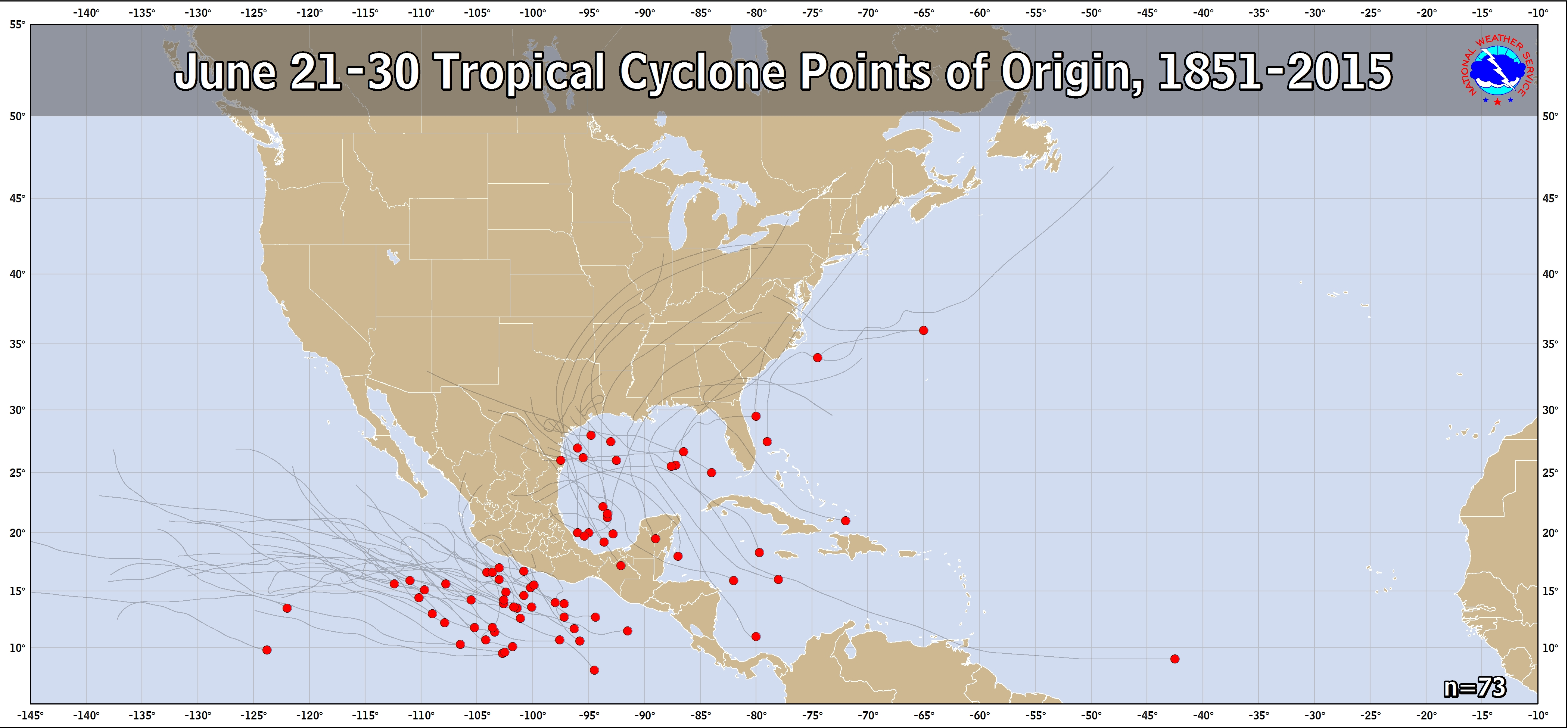
The 0Z Euro’s mid 990s mb TC 200 miles SE of the NC OB at hour 156 is almost definitely fake news. This reminds me of that fake cyclone the Euro had earlier this month forming a mere 25 miles offshore the E coast of FL moving south, which I also called fake and was. This one isn't as obvious a fake admittedly, but I still highly doubt this one is real. For one thing, the prior Euro run had nothing of the sort. Also, neither the 0z/6Z GFS nor the 0Z CMC has anything like that. Furthermore, only 2 other members of the 50 member 0Z EPS and no members of the last few GEFS had anything of similar strength. The 0Z ICON had something similar at hour 126 but the 6Z at hour 120 dropped it. Also, the CMC at 12Z yesterday had something further south but the 0Z dropped that. Future runs of those models may show it again. So, don't be surprised. If this were August or Sept, I might give it a little more credibility. But this is late June, a very quiet time of year there. Climo is always in the back of my mind when analyzing possibilities:
June 21-30 TC tracks since 1851: only one in the last 167 years on record to have formed within 200 miles of where the 0Z Euro has it forming:
https://www.nhc.noaa.gov/climo/images/jun_21_30.png
I’d be highly surprised if the 12Z Euro has anything like this but we’ll see. Even if it does, I seriously doubt I'd buy into it. This feeling is despite the well above normal SSTs in that area.
Last edited by LarryWx on Sun Jun 24, 2018 9:33 am, edited 1 time in total.
1 likes
Personal Forecast Disclaimer:
The posts in this forum are NOT official forecasts and should not be used as such. They are just the opinion of the poster and may or may not be backed by sound meteorological data. They are NOT endorsed by any professional institution or storm2k.org. For official information, please refer to the NHC and NWS products.
The posts in this forum are NOT official forecasts and should not be used as such. They are just the opinion of the poster and may or may not be backed by sound meteorological data. They are NOT endorsed by any professional institution or storm2k.org. For official information, please refer to the NHC and NWS products.
Who is online
Users browsing this forum: Chris90, Google Adsense [Bot] and 141 guests