
Strong convection fired off along 40W just north of 10N in the past 12 hrs.
Got a defined low-level vort out of it and an anticyclone.
Looking at SAL, it seems to be a protected pouch.
Models not on it yet; seems like GFS hasn't initialized the LL vort.
Keeping an eye on it.
2018 Tropics: Global Model Runs Discussion (Out to day 16)
Moderator: S2k Moderators
Forum rules

The posts in this forum are NOT official forecasts and should not be used as such. They are just the opinion of the poster and may or may not be backed by sound meteorological data. They are NOT endorsed by any professional institution or STORM2K. For official information, please refer to products from the National Hurricane Center and National Weather Service.
-
Ivanhater

- Storm2k Moderator

- Posts: 10852
- Age: 37
- Joined: Fri Jul 01, 2005 8:25 am
- Location: Pensacola
Re: 2018 Tropics: Global Model Runs Discussion (Out to day 16)
Seems odd we are not even getting the usual phantom storms on the models
2 likes
Michael
-
cycloneye

- Admin

- Posts: 139020
- Age: 67
- Joined: Thu Oct 10, 2002 10:54 am
- Location: San Juan, Puerto Rico
Re: 2018 Tropics: Global Model Runs Discussion (Out to day 16)
Ivanhater wrote:Seems odd we are not even getting the usual phantom storms on the models
Maybe they tweaked that bug.
1 likes
Visit the Caribbean-Central America Weather Thread where you can find at first post web cams,radars
and observations from Caribbean basin members Click Here
and observations from Caribbean basin members Click Here
-
NotSparta

- Professional-Met

- Posts: 1645
- Age: 22
- Joined: Fri Aug 18, 2017 8:24 am
- Location: Naples, FL
- Contact:
Re: 2018 Tropics: Global Model Runs Discussion (Out to day 16)
Ivanhater wrote:Seems odd we are not even getting the usual phantom storms on the models
The GFS keeps showing an MDR vort at 384 hours
0 likes
This post was probably an opinion of mine, and in no way is official. Please refer to http://www.hurricanes.gov for official tropical analysis and advisories.
My website, with lots of tropical wx graphics, including satellite and recon: http://cyclonicwx.com
My website, with lots of tropical wx graphics, including satellite and recon: http://cyclonicwx.com

Re: 2018 Tropics: Global Model Runs Discussion (Out to day 16)
Given the SSTs have been so cool lately but appear to be warming up, is anyone else thinking it's simply going to take a few days (or longer) for the models to respond to the change ?
0 likes
The above post is not official and should not be used as such. It is the opinion of the poster and may or may not be backed by sound meteorological data. It is not endorsed by any professional institution or storm2k.org. For official information, please refer to the NHC and NWS products.

Re: 2018 Tropics: Global Model Runs Discussion (Out to day 16)
Hammy wrote:Given the SSTs have been so cool lately but appear to be warming up, is anyone else thinking it's simply going to take a few days (or longer) for the models to respond to the change ?
Any idea why the SST's have been so cool?
0 likes
-
NotSparta
- Professional-Met
- Posts: 1645
- Age: 22
- Joined: Fri Aug 18, 2017 8:24 am
- Location: Naples, FL
- Contact:
Re: 2018 Tropics: Global Model Runs Discussion (Out to day 16)
Cuda wrote:Hammy wrote:Given the SSTs have been so cool lately but appear to be warming up, is anyone else thinking it's simply going to take a few days (or longer) for the models to respond to the change ?
Any idea why the SST's have been so cool?
Enhanced trades & more SAL than usual
1 likes
This post was probably an opinion of mine, and in no way is official. Please refer to http://www.hurricanes.gov for official tropical analysis and advisories.
My website, with lots of tropical wx graphics, including satellite and recon: http://cyclonicwx.com
My website, with lots of tropical wx graphics, including satellite and recon: http://cyclonicwx.com
-
Hurricaneman

- Category 5

- Posts: 7280
- Age: 43
- Joined: Tue Aug 31, 2004 3:24 pm
- Location: central florida
Re: 2018 Tropics: Global Model Runs Discussion (Out to day 16)
Both the GFS and EURO have a wave coming off Africa in 6 to 7 days looking at things the Euro has this wave coming off at about 23n while the GFS is at about 15n based on looking at these models I’m thinking the GFS might have a better handle on where this hits water than the Euro and this is also based on the models having waves come off too far north which the GFS seems to be better the last 2 years since the upgrade of the GFS while it seems the EURO is getting worse with its last upgrade
0 likes
Re: 2018 Tropics: Global Model Runs Discussion (Out to day 16)
GFS is starting to form strong tropical storms over Africa which is usually an indication that it's starting to pick up the pattern change that flips the switch.
4 likes
The above post is not official and should not be used as such. It is the opinion of the poster and may or may not be backed by sound meteorological data. It is not endorsed by any professional institution or storm2k.org. For official information, please refer to the NHC and NWS products.
-
gatorcane

- S2K Supporter

- Posts: 23499
- Age: 46
- Joined: Sun Mar 13, 2005 3:54 pm
- Location: Boca Raton, FL
Re: 2018 Tropics: Global Model Runs Discussion (Out to day 16)
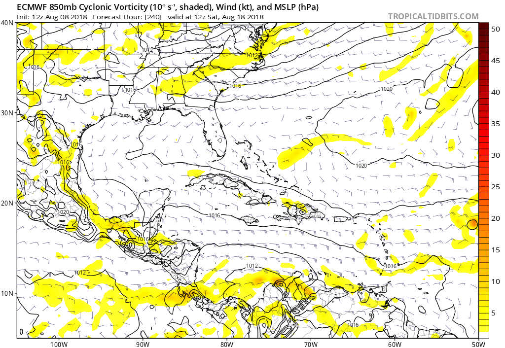
12Z ECMWF has an organizing closed surface low at 240 hours heading west from the strong tropical wave that will exit the African coast this weekend. See right side of image east of Lesser Antilles:
0 likes
-
CyclonicFury

- Category 5
- Posts: 1971
- Age: 25
- Joined: Sun Jul 02, 2017 12:32 pm
- Location: NC
- Contact:
Re: 2018 Tropics: Global Model Runs Discussion (Out to day 16)
gatorcane wrote:12Z ECMWF has an organizing closed surface low at 240 hours heading west from the strong tropical wave that will exit the African coast this weekend. See right side of image east of Lesser Antilles:
It's getting to be that time of year. With the MDR warming up a lot recently and mid-August just a week away, wouldn't be surprising to see the models light up with more activity pretty soon.
2 likes
NCSU B.S. in Meteorology Class of 2021. Tropical weather blogger at http://www.cyclonicfury.com. My forecasts and thoughts are NOT official, for official forecasts please consult the National Hurricane Center.
-
Dylan

- Professional-Met
- Posts: 337
- Age: 29
- Joined: Mon May 31, 2010 9:50 am
- Location: New Orleans, LA
Re: 2018 Tropics: Global Model Runs Discussion (Out to day 16)
1 likes
Georges('98), Allison('01), Isidore('02), Lili('02), Frances('04) Ivan('04), Cindy('05), Katrina('05), Rita('05), Gustav('08), Isaac('12), Matthew('16), Harvey('17), Irma('17), Nate ('17), Ida ('21).
Re: 2018 Tropics: Global Model Runs Discussion (Out to day 16)
models are tending toward another Debby next week. Same general area. EC quite a bit stronger though
1 likes
-
Dylan
- Professional-Met
- Posts: 337
- Age: 29
- Joined: Mon May 31, 2010 9:50 am
- Location: New Orleans, LA
Re: 2018 Tropics: Global Model Runs Discussion (Out to day 16)
Alyono wrote:models are tending toward another Debby next week. Same general area. EC quite a bit stronger though
That would make 3/5 named storms this year of non-tropical origin. We all knew this would likely happen with the warm water anomalies focused in the sun-tropics. What an incredible reversal from last year!
0 likes
Georges('98), Allison('01), Isidore('02), Lili('02), Frances('04) Ivan('04), Cindy('05), Katrina('05), Rita('05), Gustav('08), Isaac('12), Matthew('16), Harvey('17), Irma('17), Nate ('17), Ida ('21).
-
galaxy401

- Category 5
- Posts: 2298
- Age: 28
- Joined: Sat Aug 25, 2012 9:04 pm
- Location: Casa Grande, Arizona
Re: 2018 Tropics: Global Model Runs Discussion (Out to day 16)
Dylan wrote:Alyono wrote:models are tending toward another Debby next week. Same general area. EC quite a bit stronger though
That would make 3/5 named storms this year of non-tropical origin. We all knew this would likely happen with the warm water anomalies focused in the sun-tropics. What an incredible reversal from last year!
Reminds me somewhat of 2010 and 2011. Both had the same number of storms forming but 2010 was heavily focused in the MDR while 2011 was in the subtropics.
0 likes
Got my eyes on moving right into Hurricane Alley: Florida.
-
Hurricaneman
- Category 5
- Posts: 7280
- Age: 43
- Joined: Tue Aug 31, 2004 3:24 pm
- Location: central florida
Re: 2018 Tropics: Global Model Runs Discussion (Out to day 16)
The Euro and GFS still have a strong wave moving off of Africa in 6 days but the GFS does almost nothing with it while the Euro tries to develop it, based on climatology I’d be more likely to go with the Euro on this feature as when it comes to tropical waves developing the Euro seems to do better the last year or 2 while the GFS play catch-up, I can name several examples
Beryl 2018
Debby 2018
Chris 2018
Harvey 2017
Joaquin 2015
and several others
Beryl 2018
Debby 2018
Chris 2018
Harvey 2017
Joaquin 2015
and several others
0 likes

Re: 2018 Tropics: Global Model Runs Discussion (Out to day 16)
Looks like not much but rain, troughiness and boundaries along the Gulf Coast for the next couple of weeks. All the rain should keep the shelf waters at least neutral if not cool. I don’t see anything this way for at least a couple of weeks though you never know for sure. If 2002 is an analog at some level, maybe we see something later on up this way?
One Caveat is that the GFS is predicting a straight dive to Phase 2 of the MJO. The ECMWF doesn't go as fast and sort of keeps it in the circle, whereas the JMA bolts to Phase 4. Not sure which will end up being right, but obviously Phase 2 has been a strong indicator of where to look the last 2 years.
http://www.cpc.ncep.noaa.gov/products/p ... r_wh.shtml
0 likes
-
MississippiWx

- S2K Supporter
- Posts: 1535
- Joined: Sat Aug 14, 2010 1:44 pm
- Location: Hattiesburg, Mississippi
Re: 2018 Tropics: Global Model Runs Discussion (Out to day 16)
Ivanhater wrote:Seems odd we are not even getting the usual phantom storms on the models
Sinking air has been a killer over the Atlantic for a while now. Have you noticed how it's even difficult for just a few thunderstorms to thrive? It's August, and we barely have had any clusters of thunderstorms associated with tropical waves. Welcome to the -AMO years.
0 likes
This post is not an official forecast and should not be used as such. It is just the opinion of MississippiWx and may or may not be backed by sound meteorological data. It is not endorsed by any professional institution including storm2k.org. For Official Information please refer to the NHC and NWS products.
-
PTrackerLA

- Category 5
- Posts: 5248
- Age: 40
- Joined: Thu Oct 10, 2002 8:40 pm
- Location: Lafayette, LA
Re: 2018 Tropics: Global Model Runs Discussion (Out to day 16)
MississippiWx wrote:Ivanhater wrote:Seems odd we are not even getting the usual phantom storms on the models
Sinking air has been a killer over the Atlantic for a while now. Have you noticed how it's even difficult for just a few thunderstorms to thrive? It's August, and we barely have had any clusters of thunderstorms associated with tropical waves. Welcome to the -AMO years.
Seems like back in the 90's and 2000's we would have several distinct tropical waves move through here during summer. They definitely seem less common in recent years.
0 likes
-
MississippiWx
- S2K Supporter
- Posts: 1535
- Joined: Sat Aug 14, 2010 1:44 pm
- Location: Hattiesburg, Mississippi
Re: 2018 Tropics: Global Model Runs Discussion (Out to day 16)
PTrackerLA wrote:MississippiWx wrote:Ivanhater wrote:Seems odd we are not even getting the usual phantom storms on the models
Sinking air has been a killer over the Atlantic for a while now. Have you noticed how it's even difficult for just a few thunderstorms to thrive? It's August, and we barely have had any clusters of thunderstorms associated with tropical waves. Welcome to the -AMO years.
Seems like back in the 90's and 2000's we would have several distinct tropical waves move through here during summer. They definitely seem less common in recent years.
A lot of our tropical moisture/activity comes from the Caribbean. For whatever reason, the Caribbean has been a graveyard and extremely hostile to even tropical waves over the last decade. We have had a storm here and there, but nothing like the early 2000s and late 90s. I imagine this is also part of some sort of decadal process, though I am unaware of any name or study on it.
0 likes
This post is not an official forecast and should not be used as such. It is just the opinion of MississippiWx and may or may not be backed by sound meteorological data. It is not endorsed by any professional institution including storm2k.org. For Official Information please refer to the NHC and NWS products.
Who is online
Users browsing this forum: cheezyWXguy, Google Adsense [Bot], JaviT, kevin and 80 guests