2018 Tropics: Global Model Runs Discussion (Out to day 16)
Moderator: S2k Moderators
Forum rules

The posts in this forum are NOT official forecasts and should not be used as such. They are just the opinion of the poster and may or may not be backed by sound meteorological data. They are NOT endorsed by any professional institution or STORM2K. For official information, please refer to products from the National Hurricane Center and National Weather Service.
Re: 2018 Tropics: Global Model Runs Discussion (Out to day 16)
1 likes
The above post and any post by Ntxw is NOT an official forecast and should not be used as such. It is just the opinion of the poster and may or may not be backed by sound meteorological data. It is NOT endorsed by any professional institution including Storm2k. For official information, please refer to NWS products.
Help support Storm2K!
Re: 2018 Tropics: Global Model Runs Discussion (Out to day 16)
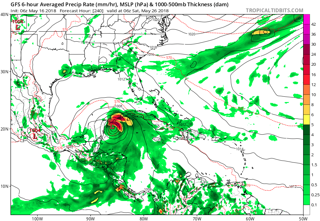
Hammy wrote:LarryWx wrote:The 12Z FV3 develops a very tiny 996 mb TS 75 miles offshore in the Apalachee Bay 5/21. That looks like still another phantom. The SSTs up there are not even warm enough for tropical development! I have a feeling this is going to be a looooong season of phantoms. :(
Isn't this basically the norm for May and June though?
I agree with you and Ntxw about June to some extent and even more for October on the GFS, but May? I don't ever recall supposed phantoms dominating May like this before.
2 likes
Personal Forecast Disclaimer:
The posts in this forum are NOT official forecasts and should not be used as such. They are just the opinion of the poster and may or may not be backed by sound meteorological data. They are NOT endorsed by any professional institution or storm2k.org. For official information, please refer to the NHC and NWS products.
The posts in this forum are NOT official forecasts and should not be used as such. They are just the opinion of the poster and may or may not be backed by sound meteorological data. They are NOT endorsed by any professional institution or storm2k.org. For official information, please refer to the NHC and NWS products.
-
CyclonicFury

- Category 5

- Posts: 1971
- Age: 25
- Joined: Sun Jul 02, 2017 12:32 pm
- Location: NC
- Contact:
Re: 2018 Tropics: Global Model Runs Discussion (Out to day 16)
There seems to be a consensus among nearly all of the global models that a Central American Gyre is likely to form. Most models develop a broad low in the NW Caribbean as a result in about 8-9 days.
0 likes
NCSU B.S. in Meteorology Class of 2021. Tropical weather blogger at http://www.cyclonicfury.com. My forecasts and thoughts are NOT official, for official forecasts please consult the National Hurricane Center.
-
Kingarabian

- S2K Supporter

- Posts: 15432
- Joined: Sat Aug 08, 2009 3:06 am
- Location: Honolulu, Hawaii
Re: 2018 Tropics: Global Model Runs Discussion (Out to day 16)
1004mb low on the 00z Euro @ 240 hours. I wonder if it's a possible phantom on the Euro as well since it keeps pushing development back.
0 likes
RIP Kobe Bryant
-
AJC3

- Admin

- Posts: 3868
- Age: 60
- Joined: Tue Aug 31, 2004 7:04 pm
- Location: West Melbourne, Florida
- Contact:
Re: 2018 Tropics: Global Model Runs Discussion (Out to day 16)
00Z ECM is a little stronger at H240 with its depiction of the NW Caribbean low. It now has it down to about 1004MB, a little SE of Cozumel and moving slowly NNW to N.
0 likes

Re: 2018 Tropics: Global Model Runs Discussion (Out to day 16)
This is nothing new when we could be dealing with monsoonal development right after the MJO passes through our part of the world, development usually happens later than sooner, the Euro agrees with the GFS, and it has also been extending the timeline.
0 likes

Re: 2018 Tropics: Global Model Runs Discussion (Out to day 16)
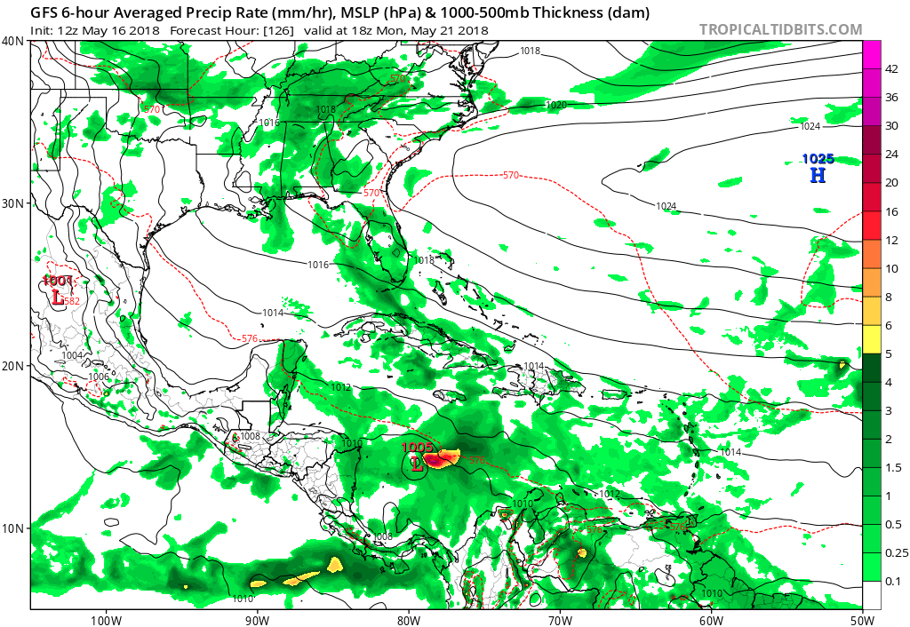
Starting to build global model support for a western caribbean system east of the Yuc or near the NE tip of the Yuc in 9-10 days moving north into the GOM. We have the new GFS, GFS, ECM, and now GEM on board with various degrees of low pressure development.
0 likes
-
gatorcane

- S2K Supporter
- Posts: 23499
- Age: 46
- Joined: Sun Mar 13, 2005 3:54 pm
- Location: Boca Raton, FL
Re: 2018 Tropics: Global Model Runs Discussion (Out to day 16)
ronjon wrote:Starting to build global model support for a western caribbean system east of the Yuc or near the NE tip of the Yuc in 9-10 days moving north into the GOM. We have the new GFS, GFS, ECM, and now GEM on board with various degrees of low pressure development.
Yep overnight models coming in more bullish with some good consensus. Latest GFS much more bullish, similar to the 00Z ECMWF but much stronger. It does indeed look like development chances are increasing. Yes the GFS spun up unrealistic CAT 2/3 phantom storms but may just have got the general idea of development correct after all.
0 likes
-
Ivanhater

- Storm2k Moderator

- Posts: 10852
- Age: 37
- Joined: Fri Jul 01, 2005 8:25 am
- Location: Pensacola
Re: 2018 Tropics: Global Model Runs Discussion (Out to day 16)
Euro certainly looks like something forming in the NW Caribbean
https://weather.us/model-charts/euro/mi ... 0000z.html
https://weather.us/model-charts/euro/mi ... 0000z.html
0 likes
Michael
-
wxman57

- Moderator-Pro Met

- Posts: 22480
- Age: 66
- Joined: Sat Jun 21, 2003 8:06 pm
- Location: Houston, TX (southwest)
Re: 2018 Tropics: Global Model Runs Discussion (Out to day 16)
There's enough of a model consensus now for development in the western Caribbean Sea around next Friday that we need to keep an eye on that region next week. Let's see if convection begins to increase across the area over the next 3-5 days.
4 likes
-
TheStormExpert

- Category 5
- Posts: 8487
- Age: 30
- Joined: Wed Feb 16, 2011 5:38 pm
- Location: Palm Beach Gardens, FL
Re: 2018 Tropics: Global Model Runs Discussion (Out to day 16)
0 likes
The following post is NOT an official forecast and should not be used as such. It is just the opinion of the poster and may or may not be backed by sound meteorological data. It is NOT endorsed by storm2k.org.
-
cycloneye

- Admin
- Posts: 139021
- Age: 67
- Joined: Thu Oct 10, 2002 10:54 am
- Location: San Juan, Puerto Rico
Re: 2018 Tropics: Global Model Runs Discussion (Out to day 16)
Note= We will stick posting model runs in this thread and not make a new thread for area that they say will have a chance to develop until one of the following two things happen.
------------------------------------------------------------------------------------------
1-There has to be an incipient area of disturbed weather.
2-A STWO has to be issued.
------------------------------------------------------------------------------------------
Thank you for your cooperation on this.
------------------------------------------------------------------------------------------
1-There has to be an incipient area of disturbed weather.
2-A STWO has to be issued.
------------------------------------------------------------------------------------------
Thank you for your cooperation on this.
3 likes
Visit the Caribbean-Central America Weather Thread where you can find at first post web cams,radars
and observations from Caribbean basin members Click Here
and observations from Caribbean basin members Click Here
-
cycloneye
- Admin
- Posts: 139021
- Age: 67
- Joined: Thu Oct 10, 2002 10:54 am
- Location: San Juan, Puerto Rico
Re: 2018 Tropics: Global Model Runs Discussion (Out to day 16)
Good discussion here about GFS phantoms.
@splillo
After a run or two had backed off the full-blown Gulf hurricane, the GFS refuses to give up. Latest 6z produces a sub-960mb TC at 312hrs.
We're going into day TEN of runs with long-range TCs; a fixture of the model at long lead times.
This is a problem.
https://twitter.com/splillo/status/996769620987129859
@mattlanza
Replying to @splillo
Unusable.Almost in totality. Ensemble mean & spread, particularly from ECMWF has been of some operational value I think. I have issues with GEFS guidance too though.
https://twitter.com/mattlanza/status/996770179945254914
@TropicalTidbits
Well having the MJO in phase 1 during May throws gasoline on the problem, guaranteed.
https://twitter.com/TropicalTidbits/status/996772914354688002
0 likes
Visit the Caribbean-Central America Weather Thread where you can find at first post web cams,radars
and observations from Caribbean basin members Click Here
and observations from Caribbean basin members Click Here
-
cycloneye
- Admin
- Posts: 139021
- Age: 67
- Joined: Thu Oct 10, 2002 10:54 am
- Location: San Juan, Puerto Rico
Re: 2018 Tropics: Global Model Runs Discussion (Out to day 16)
After discussion above,Levi Cowan tweets this.
@TropicalTidbits
Despite GFS bias, anomalous convection is likely in the W. Carib. as upper-level forcing perturbs the region for next 6 days. More than one model shows a vorticity anomaly creeping northward near CA in 6-9 days, which is not a crazy solution. That's the extent of what we can say.
https://twitter.com/TropicalTidbits/status/996775367921885184
0 likes
Visit the Caribbean-Central America Weather Thread where you can find at first post web cams,radars
and observations from Caribbean basin members Click Here
and observations from Caribbean basin members Click Here
-
SFLcane

- S2K Supporter
- Posts: 9606
- Age: 46
- Joined: Sat Jun 05, 2010 1:44 pm
- Location: Lake Worth Florida
Re: 2018 Tropics: Global Model Runs Discussion (Out to day 16)
As wxman57 stated previously with some consensus now its time to start monitoring the western carib.
1 likes
-
gatorcane
- S2K Supporter
- Posts: 23499
- Age: 46
- Joined: Sun Mar 13, 2005 3:54 pm
- Location: Boca Raton, FL
Re: 2018 Tropics: Global Model Runs Discussion (Out to day 16)
12Z GFS coming in with a 1005MB low only 5 days away now. The vorticity appears to be on the northeastern edge of the overall monsoon gyre:
Last edited by gatorcane on Wed May 16, 2018 11:11 am, edited 1 time in total.
0 likes
-
cycloneye
- Admin
- Posts: 139021
- Age: 67
- Joined: Thu Oct 10, 2002 10:54 am
- Location: San Juan, Puerto Rico
Re: 2018 Tropics: Global Model Runs Discussion (Out to day 16)
at 12z GFS run,things begin to evolve by next Monday.

0 likes
Visit the Caribbean-Central America Weather Thread where you can find at first post web cams,radars
and observations from Caribbean basin members Click Here
and observations from Caribbean basin members Click Here
-
gatorcane
- S2K Supporter
- Posts: 23499
- Age: 46
- Joined: Sun Mar 13, 2005 3:54 pm
- Location: Boca Raton, FL
Re: 2018 Tropics: Global Model Runs Discussion (Out to day 16)
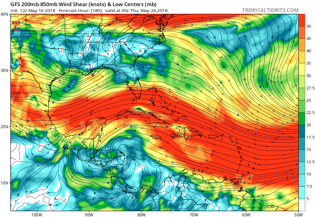
The 12Z GFS has a slightly stronger trough in the EGOM and a slightly more amplified short-wave over SE Canada (to weaken the Bermuda High a bit more) so we'll see if the result is this system ends up a bit more east in the NW Caribbean rather than more west over the Yucatan / Southern GOM.
Nice anticyclone sitting right over the low on the Honduras/Nicaragua coast at 180 hours:
Nice anticyclone sitting right over the low on the Honduras/Nicaragua coast at 180 hours:
0 likes
-
TheStormExpert
- Category 5
- Posts: 8487
- Age: 30
- Joined: Wed Feb 16, 2011 5:38 pm
- Location: Palm Beach Gardens, FL
Re: 2018 Tropics: Global Model Runs Discussion (Out to day 16)
12z GFS looks to move it straight into Honduras near the Honduras/Nicaragua border.
Edit: 12z looks to be much weaker than 06z.
Edit: 12z looks to be much weaker than 06z.
0 likes
The following post is NOT an official forecast and should not be used as such. It is just the opinion of the poster and may or may not be backed by sound meteorological data. It is NOT endorsed by storm2k.org.
-
gatorcane
- S2K Supporter
- Posts: 23499
- Age: 46
- Joined: Sun Mar 13, 2005 3:54 pm
- Location: Boca Raton, FL
Re: 2018 Tropics: Global Model Runs Discussion (Out to day 16)
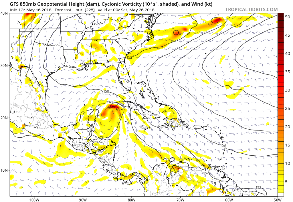
Heading N in the NW Caribbean with increasing vorticity at 228 hours:
0 likes
Who is online
Users browsing this forum: aspen, Google Adsense [Bot], mufasa157, TeamPlayersBlue and 85 guests