2018 Tropics: Global Model Runs Discussion (Out to day 16)

This is the general tropical discussion area. Anyone can take their shot at predicting a storms path.

Moderator: S2k Moderators

Forum rules

The posts in this forum are NOT official forecasts and should not be used as such. They are just the opinion of the poster and may or may not be backed by sound meteorological data. They are NOT endorsed by any professional institution or STORM2K. For official information, please refer to products from the National Hurricane Center and National Weather Service.

Help Support Storm2K
Message
Author
User avatar
Kazmit
Category 5
Category 5
Posts: 1915
Age: 21
Joined: Mon Jul 25, 2016 8:49 am
Location: Williamsburg VA for college, Bermuda otherwise

Re: 2018 Tropics: Global Model Runs Discussion (Out to day 16)

#1761 Postby Kazmit » Wed Sep 12, 2018 6:51 pm

CyclonicFury wrote:
Kazmit wrote:
CyclonicFury wrote: :uarrow: I wouldn't be surprised if we squeezed out one more storm from the MDR before the end of September, which would probably be the last of the year.

Why would it be the last of the year? There are still two more months of hurricane season after that.

I'm not talking about the last storm of the Atlantic, I expect several more. I am talking about the MDR specifically which rarely has activity after the end of September.

True, that makes a lot more sense.
1 likes   
Igor 2010, Sandy 2012, Fay 2014, Gonzalo 2014, Joaquin 2015, Nicole 2016, Humberto 2019

I am only a tropical weather enthusiast. My predictions are not official and may or may not be backed by sound meteorological data. For official information, please refer to the NHC and NWS products.

HurricaneEric
Tropical Storm
Tropical Storm
Posts: 146
Age: 29
Joined: Mon Sep 07, 2015 11:06 am
Location: Miami, FL

Re: 2018 Tropics: Global Model Runs Discussion (Out to day 16)

#1762 Postby HurricaneEric » Fri Sep 14, 2018 7:45 am

Not sure what to make of this, but from hours 120-240 there seems to be growing chances of cyclone genesis in the SW Caribbean:

Image

Image

Also, the 00z Euro last night has a 1005mb (weak TS?) low at a low latitude in the MDR.

Image

Image

Would seem to come around the end of September which Ben Noll has been talking about in terms of an uptick in activity across the basin.


Sent from my iPhone using Tapatalk
1 likes   
Irene '99, Katrina '05, Wilma '05, Irma '17 (storms I remember my area getting hurricane force winds/gusts).

The posts in this forum are NOT official forecast and shouldn't be used as such. They are just the opinion of the poster and may or may not be backed by sound meteorological data. For official information, please refer to the experts.

User avatar
TheStormExpert
Category 5
Category 5
Posts: 8487
Age: 30
Joined: Wed Feb 16, 2011 5:38 pm
Location: Palm Beach Gardens, FL

Re: 2018 Tropics: Global Model Runs Discussion (Out to day 16)

#1763 Postby TheStormExpert » Fri Sep 14, 2018 8:47 am

Yeah the recent GFS runs has been hinting at extreme long-range development in the SW Caribbean in the final days of September. Not surprised considering that after a week or two of quiet conditions after the currently four active tropical cyclones leave the picture things should pick-up again.
0 likes   
The following post is NOT an official forecast and should not be used as such. It is just the opinion of the poster and may or may not be backed by sound meteorological data. It is NOT endorsed by storm2k.org.

User avatar
CourierPR
Category 5
Category 5
Posts: 1325
Age: 70
Joined: Tue Aug 31, 2004 7:53 pm
Location: Pompano Beach, Florida

Re: 2018 Tropics: Global Model Runs Discussion (Out to day 16)

#1764 Postby CourierPR » Fri Sep 14, 2018 10:13 am

TheStormExpert wrote:Yeah the recent GFS runs has been hinting at extreme long-range development in the SW Caribbean in the final days of September. Not surprised considering that after a week or two of quiet conditions after the currently four active tropical cyclones leave the picture things should pick-up again.


Met. Joe Bastardi tweeted about this this morning. In fact, he alluded to it days ago.
1 likes   

User avatar
Hurricaneman
Category 5
Category 5
Posts: 7281
Age: 43
Joined: Tue Aug 31, 2004 3:24 pm
Location: central florida

Re: 2018 Tropics: Global Model Runs Discussion (Out to day 16)

#1765 Postby Hurricaneman » Fri Sep 14, 2018 4:23 pm

Also look for another subtropical development near where Joyce formed according to the models
0 likes   

User avatar
abajan
S2K Supporter
S2K Supporter
Posts: 4175
Joined: Sun Sep 07, 2003 5:10 am
Location: Barbados

Re: 2018 Tropics: Global Model Runs Discussion (Out to day 16)

#1766 Postby abajan » Fri Sep 14, 2018 5:38 pm

HurricaneEric wrote:...
https://uploads.tapatalk-cdn.com/20180914/27cab31b33c0225760b9a83258a91ba7.png

Would seem to come around the end of September which Ben Noll has been talking about in terms of an uptick in activity across the basin.

12z Euro isn't showing that system in the mid Atlantic.
0 likes   

User avatar
MetroMike
Category 3
Category 3
Posts: 826
Joined: Sun Aug 29, 2004 8:13 pm
Location: Tampa Bay
Contact:

Re: 2018 Tropics: Global Model Runs Discussion (Out to day 16)

#1767 Postby MetroMike » Fri Sep 14, 2018 6:13 pm

CourierPR wrote:
TheStormExpert wrote:Yeah the recent GFS runs has been hinting at extreme long-range development in the SW Caribbean in the final days of September. Not surprised considering that after a week or two of quiet conditions after the currently four active tropical cyclones leave the picture things should pick-up again.


Met. Joe Bastardi tweeted about this this morning. In fact, he alluded to it days ago.


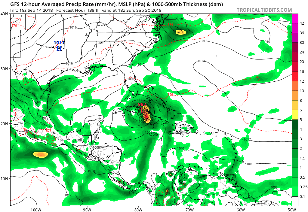
Yes the 18Z GFS has it coming north over Cuba on the 30th at runs end. GFS has not shown many phantom storms lately so bears watching.
0 likes   

User avatar
Hammy
Category 5
Category 5
Posts: 5594
Age: 40
Joined: Fri May 25, 2012 5:25 pm
Contact:

Re: 2018 Tropics: Global Model Runs Discussion (Out to day 16)

#1768 Postby Hammy » Fri Sep 14, 2018 6:47 pm

MetroMike wrote:
CourierPR wrote:
TheStormExpert wrote:Yeah the recent GFS runs has been hinting at extreme long-range development in the SW Caribbean in the final days of September. Not surprised considering that after a week or two of quiet conditions after the currently four active tropical cyclones leave the picture things should pick-up again.


Met. Joe Bastardi tweeted about this this morning. In fact, he alluded to it days ago.


Yes the 18Z GFS has it coming north over Cuba on the 30th at runs end. GFS has not shown many phantom storms lately so bears watching.


Interesting thing I observed earlier with the GFS, at least in the deep tropics, while it misses storms it's read the pattern with developing systems pretty far out, but a bit ahead of time. It actually showed two systems at once near the end of the run in the last week of August, and of course this came true a few weeks later, so entirely plausible it's right here as well but it occurs in the second week of October.
1 likes   
The above post is not official and should not be used as such. It is the opinion of the poster and may or may not be backed by sound meteorological data. It is not endorsed by any professional institution or storm2k.org. For official information, please refer to the NHC and NWS products.

User avatar
gatorcane
S2K Supporter
S2K Supporter
Posts: 23499
Age: 46
Joined: Sun Mar 13, 2005 3:54 pm
Location: Boca Raton, FL

Re: 2018 Tropics: Global Model Runs Discussion (Out to day 16)

#1769 Postby gatorcane » Fri Sep 14, 2018 7:40 pm

How the 18Z GFS ends with an intensifying storm heading north. The FV3 GFS has a system in the Caribbean albeit weaker and a bit more east. I agree the Western Caribbean bears watching toward end of month:

Image
2 likes   

User avatar
Hurricaneman
Category 5
Category 5
Posts: 7281
Age: 43
Joined: Tue Aug 31, 2004 3:24 pm
Location: central florida

Re: 2018 Tropics: Global Model Runs Discussion (Out to day 16)

#1770 Postby Hurricaneman » Fri Sep 14, 2018 8:23 pm

gatorcane wrote:How the 18Z GFS ends with an intensifying storm heading north. The FV3 GFS has a system in the Caribbean albeit weaker and a bit more east. I agree the Western Caribbean bears watching toward end of month:

https://s8.postimg.cc/aw90zdfp1/gfs_mslp_pcpn_watl_52.png

I’m wondering if this is also the wave the Euro develops but the GFS is in the western Caribbean while the Euro is at 40w or is that a different feature
0 likes   

User avatar
Emmett_Brown
Category 5
Category 5
Posts: 1343
Joined: Wed Aug 24, 2005 9:10 pm
Location: Sarasota FL

Re: 2018 Tropics: Global Model Runs Discussion (Out to day 16)

#1771 Postby Emmett_Brown » Sat Sep 15, 2018 10:17 am

The only action the models are showing in the medium range (as in up to 240 hours out) is the reincarnation of Florence a good distance off the east coast as her low level center loops back into the area.
0 likes   

WeatherEmperor
S2K Supporter
S2K Supporter
Posts: 4806
Age: 40
Joined: Thu Sep 04, 2003 2:54 pm
Location: South Florida

2018 Tropics: Global Model Runs Discussion (Out to day 16)

#1772 Postby WeatherEmperor » Sat Sep 15, 2018 3:22 pm

Very long range on the 12z Euro

Image

Navgem has it too in a slightly different position

Image

Sent from my iPhone using Tapatalk
0 likes   

LarryWx
Category 5
Category 5
Posts: 5699
Joined: Sun Sep 07, 2003 2:04 pm
Location: GA

Re: 2018 Tropics: Global Model Runs Discussion (Out to day 16)

#1773 Postby LarryWx » Sun Sep 16, 2018 2:12 am

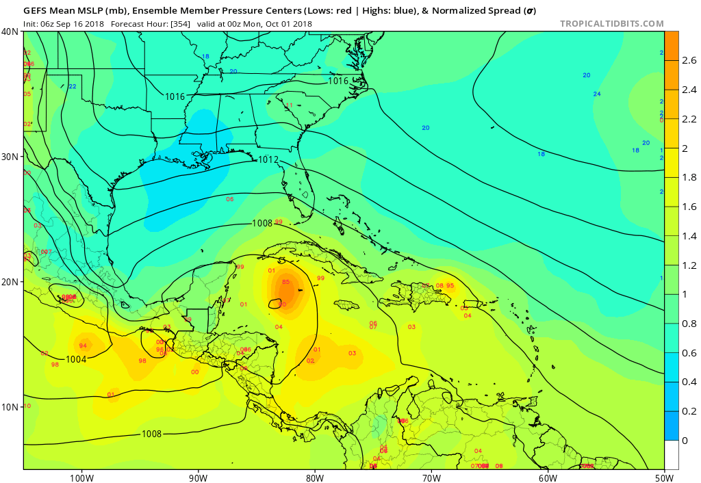
The last several GEFS are hinting at activity in the W Caribbean near the end of the month into very early Oct. 'Tis the season.
1 likes   
Personal Forecast Disclaimer:
The posts in this forum are NOT official forecasts and should not be used as such. They are just the opinion of the poster and may or may not be backed by sound meteorological data. They are NOT endorsed by any professional institution or storm2k.org. For official information, please refer to the NHC and NWS products.

bob rulz
Category 5
Category 5
Posts: 1667
Age: 34
Joined: Sat Jan 28, 2006 7:30 pm
Location: Salt Lake City, Utah

Re: 2018 Tropics: Global Model Runs Discussion (Out to day 16)

#1774 Postby bob rulz » Sun Sep 16, 2018 5:51 am

One of these days the Caribbean is going to live up to its potential again. Aside from Matthew, the last time I feel that the Caribbean had real "classic" storms was with Dean and Felix in 2007. Only other major Caribbean storms I can think of in the last decade were Otto and Gustav. I suppose Maria counts, but I'm thinking more of the home-grown Caribbean hurricanes, or the ones that rapidly intensify as they get into the Caribbean.
0 likes   

User avatar
TheStormExpert
Category 5
Category 5
Posts: 8487
Age: 30
Joined: Wed Feb 16, 2011 5:38 pm
Location: Palm Beach Gardens, FL

Re: 2018 Tropics: Global Model Runs Discussion (Out to day 16)

#1775 Postby TheStormExpert » Sun Sep 16, 2018 6:42 am

bob rulz wrote:One of these days the Caribbean is going to live up to its potential again. Aside from Matthew, the last time I feel that the Caribbean had real "classic" storms was with Dean and Felix in 2007. Only other major Caribbean storms I can think of in the last decade were Otto and Gustav. I suppose Maria counts, but I'm thinking more of the home-grown Caribbean hurricanes, or the ones that rapidly intensify as they get into the Caribbean.

I can think of a few more. Omar, and Paloma in 2008, Paula, and Tomas in 2010, and Rina in 2011.

But you’re right, it’s been awhile since we’ve seen that classic October Western Caribbean monster system, got to date back to October 2005 with Wilma.
0 likes   
The following post is NOT an official forecast and should not be used as such. It is just the opinion of the poster and may or may not be backed by sound meteorological data. It is NOT endorsed by storm2k.org.

User avatar
gatorcane
S2K Supporter
S2K Supporter
Posts: 23499
Age: 46
Joined: Sun Mar 13, 2005 3:54 pm
Location: Boca Raton, FL

Re: 2018 Tropics: Global Model Runs Discussion (Out to day 16)

#1776 Postby gatorcane » Sun Sep 16, 2018 10:11 am

LarryWx wrote:The last several GEFS are hinting at activity in the W Caribbean near the end of the month into very early Oct. 'Tis the season.


Image
1 likes   

User avatar
TheStormExpert
Category 5
Category 5
Posts: 8487
Age: 30
Joined: Wed Feb 16, 2011 5:38 pm
Location: Palm Beach Gardens, FL

Re: 2018 Tropics: Global Model Runs Discussion (Out to day 16)

#1777 Postby TheStormExpert » Sun Sep 16, 2018 10:58 am

:uarrow: EPS Ensembles favor East Pacific activity into early October FWIW.
3 likes   
The following post is NOT an official forecast and should not be used as such. It is just the opinion of the poster and may or may not be backed by sound meteorological data. It is NOT endorsed by storm2k.org.

LarryWx
Category 5
Category 5
Posts: 5699
Joined: Sun Sep 07, 2003 2:04 pm
Location: GA

Re: 2018 Tropics: Global Model Runs Discussion (Out to day 16)

#1778 Postby LarryWx » Sun Sep 16, 2018 11:10 am

TheStormExpert wrote::uarrow: EPS Ensembles favor East Pacific activity into early October FWIW.


Indeed, they do and perhaps that’s where any significant activity will be concentrated. But consider the possibility of a left bias playing a part in the EPS’ EPAC positioning. Then again, consider the possibility of a right bias in the GEFS causing it to concentrate on the W Caribbean. We’ll know the answer in a couple of weeks!
0 likes   
Personal Forecast Disclaimer:
The posts in this forum are NOT official forecasts and should not be used as such. They are just the opinion of the poster and may or may not be backed by sound meteorological data. They are NOT endorsed by any professional institution or storm2k.org. For official information, please refer to the NHC and NWS products.

User avatar
CyclonicFury
Category 5
Category 5
Posts: 1975
Age: 25
Joined: Sun Jul 02, 2017 12:32 pm
Location: NC
Contact:

Re: 2018 Tropics: Global Model Runs Discussion (Out to day 16)

#1779 Postby CyclonicFury » Sun Sep 16, 2018 11:30 am

The GFS does seem to have a bias with gyre genesis in the Western Caribbean. It developed Alberto way too early as well as that hurricane in June which never verified. Until the operational Euro and/or UKMET come on board, it's going to be hard for me to take genesis in that region seriously.
3 likes   
NCSU B.S. in Meteorology Class of 2021. Tropical weather blogger at http://www.cyclonicfury.com. My forecasts and thoughts are NOT official, for official forecasts please consult the National Hurricane Center.

User avatar
toad strangler
S2K Supporter
S2K Supporter
Posts: 4162
Joined: Sun Jul 28, 2013 3:09 pm
Location: Earth
Contact:

Re: 2018 Tropics: Global Model Runs Discussion (Out to day 16)

#1780 Postby toad strangler » Sun Sep 16, 2018 11:46 am

LarryWx wrote:
TheStormExpert wrote::uarrow: EPS Ensembles favor East Pacific activity into early October FWIW.


Indeed, they do and perhaps that’s where any significant activity will be concentrated. But consider the possibility of a left bias playing a part in the EPS’ EPAC positioning. Then again, consider the possibility of a right bias in the GEFS causing it to concentrate on the W Caribbean. We’ll know the answer in a couple of weeks!


Pretty soon this is a climo area.
1 likes   


Return to “Talkin' Tropics”

Who is online

Users browsing this forum: bird, Google Adsense [Bot], TheAustinMan and 217 guests