2018 Tropics: Global Model Runs Discussion (Out to day 16)
Moderator: S2k Moderators
Forum rules

The posts in this forum are NOT official forecasts and should not be used as such. They are just the opinion of the poster and may or may not be backed by sound meteorological data. They are NOT endorsed by any professional institution or STORM2K. For official information, please refer to products from the National Hurricane Center and National Weather Service.
-
stormlover2013
- Category 5

- Posts: 2312
- Joined: Thu Aug 22, 2013 12:06 pm
- Location: Lumberton, Texas
Re: 2018 Tropics: Global Model Runs Discussion (Out to day 16)
Lol yep and I will go with Euro and ukmet
0 likes
-
Haris

- Category 5
- Posts: 1808
- Joined: Mon Nov 27, 2017 8:19 pm
- Location: ( Bee Cave) West Austin, Texas
Re: 2018 Tropics: Global Model Runs Discussion (Out to day 16)


2 likes
Weather geek and a storm spotter in West Austin. Not a degreed meteorologist. Big snow fan. Love rain and cold! Despise heat!
-
TheStormExpert

- Category 5
- Posts: 8487
- Age: 30
- Joined: Wed Feb 16, 2011 5:38 pm
- Location: Palm Beach Gardens, FL
Re: 2018 Tropics: Global Model Runs Discussion (Out to day 16)
Tropical Tidbits Levi Cowan says to ignore the GFS’s crazy hurricane solution. Euro seems more believable.
https://twitter.com/tropicaltidbits/status/1005854485661577221
https://twitter.com/tropicaltidbits/status/1005854489390342145
https://twitter.com/tropicaltidbits/status/1005854495392305158
https://twitter.com/tropicaltidbits/status/1005854485661577221
https://twitter.com/tropicaltidbits/status/1005854489390342145
https://twitter.com/tropicaltidbits/status/1005854495392305158
1 likes
The following post is NOT an official forecast and should not be used as such. It is just the opinion of the poster and may or may not be backed by sound meteorological data. It is NOT endorsed by storm2k.org.
-
Aric Dunn
- Category 5
- Posts: 21228
- Age: 41
- Joined: Sun Sep 19, 2004 9:58 pm
- Location: Ready for the Chase.
- Contact:
Re: 2018 Tropics: Global Model Runs Discussion (Out to day 16)
TheStormExpert wrote:Tropical Tidbits Levi Cowan says to ignore the GFS’s crazy hurricane solution. Euro seems more believable.
[tweet]https://twitter.com/tropicaltidbits/status/1005854485661577221[/teet]
[tweet]https://twitter.com/tropicaltidbits/status/1005854489390342145[/twet]
[tweet]https://twitter.com/tropicaltidbits/status/1005854495392305158[/twet]
I dont think anyone was looking at the GFS for intensity lol.
3 likes
Note: If I make a post that is brief. Please refer back to previous posts for the analysis or reasoning. I do not re-write/qoute what my initial post said each time.
If there is nothing before... then just ask
Space & Atmospheric Physicist, Embry-Riddle Aeronautical University,
I believe the sky is falling...
If there is nothing before... then just ask
Space & Atmospheric Physicist, Embry-Riddle Aeronautical University,
I believe the sky is falling...
-
Aric Dunn
- Category 5
- Posts: 21228
- Age: 41
- Joined: Sun Sep 19, 2004 9:58 pm
- Location: Ready for the Chase.
- Contact:
Re: 2018 Tropics: Global Model Runs Discussion (Out to day 16)
THe monsoon trough and vorticity/broad rotation are beginning to come together per the GFS/CMC again right on QUE.

yesterdays 12z CMC captured what is currently happening now pretty well..

yesterdays 12z CMC captured what is currently happening now pretty well..
Last edited by Aric Dunn on Sun Jun 10, 2018 2:47 pm, edited 2 times in total.
4 likes
Note: If I make a post that is brief. Please refer back to previous posts for the analysis or reasoning. I do not re-write/qoute what my initial post said each time.
If there is nothing before... then just ask
Space & Atmospheric Physicist, Embry-Riddle Aeronautical University,
I believe the sky is falling...
If there is nothing before... then just ask
Space & Atmospheric Physicist, Embry-Riddle Aeronautical University,
I believe the sky is falling...
-
Aric Dunn
- Category 5
- Posts: 21228
- Age: 41
- Joined: Sun Sep 19, 2004 9:58 pm
- Location: Ready for the Chase.
- Contact:
Re: 2018 Tropics: Global Model Runs Discussion (Out to day 16)
hmmm why did that first GIF stop looping in the previous post ? weird
0 likes
Note: If I make a post that is brief. Please refer back to previous posts for the analysis or reasoning. I do not re-write/qoute what my initial post said each time.
If there is nothing before... then just ask
Space & Atmospheric Physicist, Embry-Riddle Aeronautical University,
I believe the sky is falling...
If there is nothing before... then just ask
Space & Atmospheric Physicist, Embry-Riddle Aeronautical University,
I believe the sky is falling...
-
stormreader
- Category 5
- Posts: 1242
- Joined: Fri Jun 24, 2011 10:58 am
Re: 2018 Tropics: Global Model Runs Discussion (Out to day 16)
Aric Dunn wrote:THe monsoon trough and vorticity/broad rotation are beginning to come together per the GFS/CMC again right on QUE.
https://image.ibb.co/naTKDT/regrdgvdrtbdtbftyxyb.gif
yesterdays 12z CMC captured what is currently happening now pretty well..
https://image.ibb.co/mna208/gem_z850_vo ... fh0_72.gif
Yep. That chart reflects very short range (next 48 hours). I've been looking down there too, (last couple of days) for signs of a general northward movement or storms building further north of the Costa Rica area in the SW Caribbean. With then storms building off Nicaragua and Honduras. Some waiting on an oncoming tropical wave to help add energy. Don't know about that. But been looking in SW Caribbean for something my eyes can actually see (not just in cyberspace).
0 likes
-
Aric Dunn
- Category 5
- Posts: 21228
- Age: 41
- Joined: Sun Sep 19, 2004 9:58 pm
- Location: Ready for the Chase.
- Contact:
Re: 2018 Tropics: Global Model Runs Discussion (Out to day 16)
is the First GIF looping for you ?
0 likes
Note: If I make a post that is brief. Please refer back to previous posts for the analysis or reasoning. I do not re-write/qoute what my initial post said each time.
If there is nothing before... then just ask
Space & Atmospheric Physicist, Embry-Riddle Aeronautical University,
I believe the sky is falling...
If there is nothing before... then just ask
Space & Atmospheric Physicist, Embry-Riddle Aeronautical University,
I believe the sky is falling...
-
TheProfessor

- Professional-Met

- Posts: 3505
- Age: 27
- Joined: Tue Dec 03, 2013 10:56 am
- Location: Wichita, Kansas
Re: 2018 Tropics: Global Model Runs Discussion (Out to day 16)
0 likes
An alumnus of The Ohio State University.
Your local National Weather Service office is your best source for weather information.
Your local National Weather Service office is your best source for weather information.
-
Aric Dunn
- Category 5
- Posts: 21228
- Age: 41
- Joined: Sun Sep 19, 2004 9:58 pm
- Location: Ready for the Chase.
- Contact:
Re: 2018 Tropics: Global Model Runs Discussion (Out to day 16)
TheProfessor wrote::uarrow: It is for me.
ok thanks. for some reason the TPW loop stopped working on my screen .. lol
0 likes
Note: If I make a post that is brief. Please refer back to previous posts for the analysis or reasoning. I do not re-write/qoute what my initial post said each time.
If there is nothing before... then just ask
Space & Atmospheric Physicist, Embry-Riddle Aeronautical University,
I believe the sky is falling...
If there is nothing before... then just ask
Space & Atmospheric Physicist, Embry-Riddle Aeronautical University,
I believe the sky is falling...


Re: 2018 Tropics: Global Model Runs Discussion (Out to day 16)
The 18z GFS looks more realistic with the strength of the system.

2 likes
-
Aric Dunn
- Category 5
- Posts: 21228
- Age: 41
- Joined: Sun Sep 19, 2004 9:58 pm
- Location: Ready for the Chase.
- Contact:
Re: 2018 Tropics: Global Model Runs Discussion (Out to day 16)
wxman22 wrote:The 18z GFS looks more realistic with the strength of the system.
[img]https://www.tropicaltidbits.com/analysis/models/gfs/2018061018/gfs_mslp_pcpn_frzn_scus_30.png[/ig]
yeah it spends a lot more time over land. which is likely the case given the set up./
2 likes
Note: If I make a post that is brief. Please refer back to previous posts for the analysis or reasoning. I do not re-write/qoute what my initial post said each time.
If there is nothing before... then just ask
Space & Atmospheric Physicist, Embry-Riddle Aeronautical University,
I believe the sky is falling...
If there is nothing before... then just ask
Space & Atmospheric Physicist, Embry-Riddle Aeronautical University,
I believe the sky is falling...
-
Haris
- Category 5
- Posts: 1808
- Joined: Mon Nov 27, 2017 8:19 pm
- Location: ( Bee Cave) West Austin, Texas
Re: 2018 Tropics: Global Model Runs Discussion (Out to day 16)
LOTTA rain coming TEXANS!
BENEFICIAL RAIN. 18z gfs really became weaker.
More inland track in CA. Like Euro
BENEFICIAL RAIN. 18z gfs really became weaker.
More inland track in CA. Like Euro
1 likes
Weather geek and a storm spotter in West Austin. Not a degreed meteorologist. Big snow fan. Love rain and cold! Despise heat!


Re: 2018 Tropics: Global Model Runs Discussion (Out to day 16)
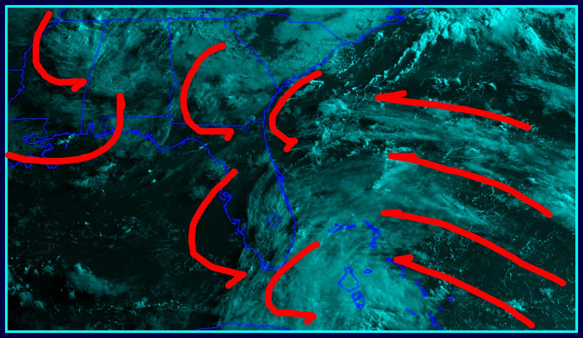
Convection and vorticiy have really increased during the day today.
Saved vis loop:

Saved vis loop:
3 likes
-
cycloneye

- Admin

- Posts: 139025
- Age: 67
- Joined: Thu Oct 10, 2002 10:54 am
- Location: San Juan, Puerto Rico
Re: 2018 Tropics: Global Model Runs Discussion (Out to day 16)
We have a thread open for the area of interest in SW Caribbean so model runs can be posted there.
Watching SW Caribbean Thread
Watching SW Caribbean Thread
4 likes
Visit the Caribbean-Central America Weather Thread where you can find at first post web cams,radars
and observations from Caribbean basin members Click Here
and observations from Caribbean basin members Click Here
-
TheStormExpert
- Category 5
- Posts: 8487
- Age: 30
- Joined: Wed Feb 16, 2011 5:38 pm
- Location: Palm Beach Gardens, FL
Re: 2018 Tropics: Global Model Runs Discussion (Out to day 16)
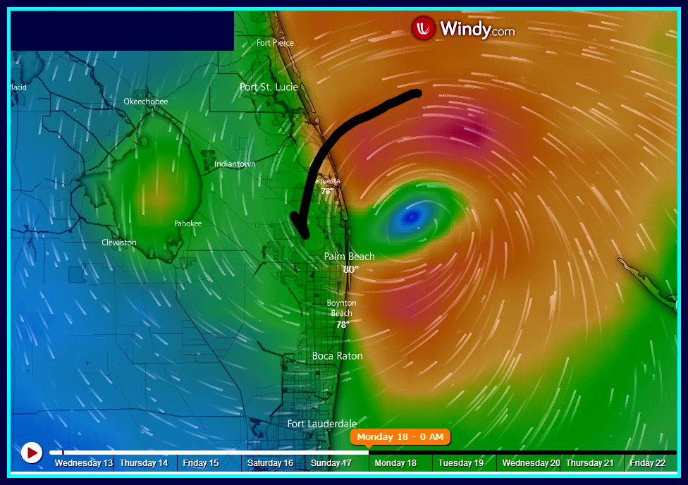
I’d be more interested in what may or not develop at the tail end of the front expected to sweep into north Florida this weekend over Invest 91L.
The 12z Euro Ensembles were hinting at the potential at development of some sort and what do you know, the 00z Euro develops what looks like a TD or very weak mini-TS off the Palm Beach/Martin County border on Monday. 00z Euro Ensembles are even more bullish.


The 12z Euro Ensembles were hinting at the potential at development of some sort and what do you know, the 00z Euro develops what looks like a TD or very weak mini-TS off the Palm Beach/Martin County border on Monday. 00z Euro Ensembles are even more bullish.
2 likes
The following post is NOT an official forecast and should not be used as such. It is just the opinion of the poster and may or may not be backed by sound meteorological data. It is NOT endorsed by storm2k.org.
-
Clearcloudz

- Category 2

- Posts: 523
- Joined: Sun Jun 10, 2018 1:46 pm
- Location: Rosenberg TX
Re: 2018 Tropics: Global Model Runs Discussion (Out to day 16)
EURO Model coming out with a homegrown tropical System off the east coast of Florida. Needs to be watched as potential is there for something to form quickly since it is inside the 5 day window on the EURO.
1 likes

Re: 2018 Tropics: Global Model Runs Discussion (Out to day 16)
00z CMC has the same vort max a little further north but buries it into the oeninsula rather than move it offshore of S FL.
https://www.tropicaltidbits.com/analysis/models/?model=gem®ion=watl&pkg=uv850_vort&runtime=2018061300&fh=96
https://www.tropicaltidbits.com/analysis/models/?model=gem®ion=watl&pkg=uv850_vort&runtime=2018061300&fh=96
0 likes
Re: 2018 Tropics: Global Model Runs Discussion (Out to day 16)
Curiously the vort max originates over south-central Georgia in both the CMC and Euro models.
0 likes
-
Clearcloudz
- Category 2
- Posts: 523
- Joined: Sun Jun 10, 2018 1:46 pm
- Location: Rosenberg TX
Re: 2018 Tropics: Global Model Runs Discussion (Out to day 16)
Over night UL energy from Invest 91L was sheared northeast over Cuba into Florida increasing chances for homegrown development off the Florida east coast as the frontal system drops.

0 likes