I think there is enough of a threat now to consider starting a new thread addressing early Oct Caribbean potential TC so it doesn’t clutter up this thread. I mean we don’t even have a discussion thread for this yet as the remnants of Kirk thread may not be the best place to discuss it. Opinions?
Meanwhile, I think that one feature that shouldn’t be overlooked is for a residual Leslie trough being left behind for a time south of Bermuda even after she finally moves NE. This residual trough may delay a rebuild of ridging south of Bermuda long enough to maintain a steering influencing weakness there long enough to be the primary reason any Caribbean low may initially lift out E of FL instead of into the Gulf. Remember that it often doesn’t take much of a 500 mb level weakness to attract a TC. Even something as subtle as this can easily do it. Example: Anyone remember Jose’s residual trough off the NE US that was just enough to keep Maria from threatening NC like some models had been showing?
2018 Tropics: Global Model Runs Discussion (Out to day 16)
Moderator: S2k Moderators
Forum rules

The posts in this forum are NOT official forecasts and should not be used as such. They are just the opinion of the poster and may or may not be backed by sound meteorological data. They are NOT endorsed by any professional institution or STORM2K. For official information, please refer to products from the National Hurricane Center and National Weather Service.
Re: 2018 Tropics: Global Model Runs Discussion (Out to day 16)
Last edited by LarryWx on Sun Sep 30, 2018 12:33 pm, edited 1 time in total.
3 likes
Personal Forecast Disclaimer:
The posts in this forum are NOT official forecasts and should not be used as such. They are just the opinion of the poster and may or may not be backed by sound meteorological data. They are NOT endorsed by any professional institution or storm2k.org. For official information, please refer to the NHC and NWS products.
The posts in this forum are NOT official forecasts and should not be used as such. They are just the opinion of the poster and may or may not be backed by sound meteorological data. They are NOT endorsed by any professional institution or storm2k.org. For official information, please refer to the NHC and NWS products.
-
gatorcane

- S2K Supporter

- Posts: 23499
- Age: 46
- Joined: Sun Mar 13, 2005 3:54 pm
- Location: Boca Raton, FL
Re: 2018 Tropics: Global Model Runs Discussion (Out to day 16)
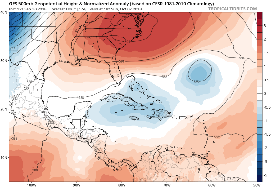
The GFS is finally unstuck and we see monster east coast ridging that turns the Caribbean system west in the Bahamas:
0 likes
Re: 2018 Tropics: Global Model Runs Discussion (Out to day 16)
gatorcane wrote:The GFS is finally unstuck and we see monster east coast ridging that turns the Caribbean system west in the Bahamas:
https://i.postimg.cc/W3BdDp5v/gfs_z500a_Norm_watl_30.png
Gator and others,
That slight relative 500 mb weakness on your map south of Bermuda, which is residual from Leslie, may very well be a key feature to determine whether any Car low initially gets pulled up E or W of FL. The model runs, including earlier FV3 and GFS runs, pulling it up E of FL are keying on that to delay the rebuilding ridging there long enough to pull it up E of FL before either continuing N and staying E of the US or turning back into the Carolinas.
Last edited by LarryWx on Sun Sep 30, 2018 12:42 pm, edited 1 time in total.
0 likes
Personal Forecast Disclaimer:
The posts in this forum are NOT official forecasts and should not be used as such. They are just the opinion of the poster and may or may not be backed by sound meteorological data. They are NOT endorsed by any professional institution or storm2k.org. For official information, please refer to the NHC and NWS products.
The posts in this forum are NOT official forecasts and should not be used as such. They are just the opinion of the poster and may or may not be backed by sound meteorological data. They are NOT endorsed by any professional institution or storm2k.org. For official information, please refer to the NHC and NWS products.
-
toad strangler

- S2K Supporter
- Posts: 4170
- Joined: Sun Jul 28, 2013 3:09 pm
- Location: Earth
- Contact:
Re: 2018 Tropics: Global Model Runs Discussion (Out to day 16)
12z GFS splits the vorticity in the Bahamas into two as if chopped in half. One goes W into the GOM towards S TX and Mexico and the other E into the open Atlantic. 
0 likes
-
Aric Dunn
- Category 5

- Posts: 21228
- Age: 41
- Joined: Sun Sep 19, 2004 9:58 pm
- Location: Ready for the Chase.
- Contact:
Re: 2018 Tropics: Global Model Runs Discussion (Out to day 16)
GFS Gobbledygook is back... lol
0 likes
Note: If I make a post that is brief. Please refer back to previous posts for the analysis or reasoning. I do not re-write/qoute what my initial post said each time.
If there is nothing before... then just ask
Space & Atmospheric Physicist, Embry-Riddle Aeronautical University,
I believe the sky is falling...
If there is nothing before... then just ask
Space & Atmospheric Physicist, Embry-Riddle Aeronautical University,
I believe the sky is falling...
-
Aric Dunn
- Category 5
- Posts: 21228
- Age: 41
- Joined: Sun Sep 19, 2004 9:58 pm
- Location: Ready for the Chase.
- Contact:
Re: 2018 Tropics: Global Model Runs Discussion (Out to day 16)
the JMA has been very consistent with keeping the KIRK vorticity as the main feature. similar to the ICON again.
0 likes
Note: If I make a post that is brief. Please refer back to previous posts for the analysis or reasoning. I do not re-write/qoute what my initial post said each time.
If there is nothing before... then just ask
Space & Atmospheric Physicist, Embry-Riddle Aeronautical University,
I believe the sky is falling...
If there is nothing before... then just ask
Space & Atmospheric Physicist, Embry-Riddle Aeronautical University,
I believe the sky is falling...
Re: 2018 Tropics: Global Model Runs Discussion (Out to day 16)
The 12Z FV3 illustrates quite well the forecasting nightmare that may be ahead and may last a long time. The run once again leaves behind a residual Leslie related 500 mb weakness long enough to attract Caribbean energy up E of FL on 10/9 instead of into the Gulf. Afterward, the very strong MidAtlantic states ridge gets established and traps it just off the SE US coast 3 days before finally moving NE OTS 10/13-14.
0 likes
Personal Forecast Disclaimer:
The posts in this forum are NOT official forecasts and should not be used as such. They are just the opinion of the poster and may or may not be backed by sound meteorological data. They are NOT endorsed by any professional institution or storm2k.org. For official information, please refer to the NHC and NWS products.
The posts in this forum are NOT official forecasts and should not be used as such. They are just the opinion of the poster and may or may not be backed by sound meteorological data. They are NOT endorsed by any professional institution or storm2k.org. For official information, please refer to the NHC and NWS products.
-
gatorcane
- S2K Supporter
- Posts: 23499
- Age: 46
- Joined: Sun Mar 13, 2005 3:54 pm
- Location: Boca Raton, FL
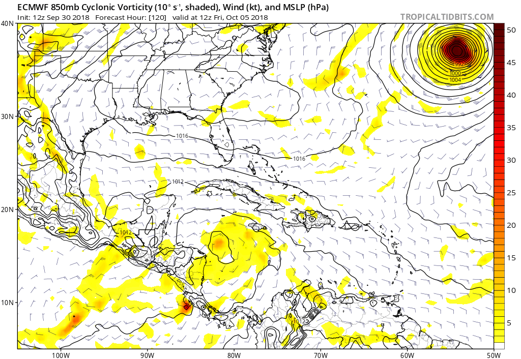
Re: 2018 Tropics: Global Model Runs Discussion (Out to day 16)
12Z Euro shows more consolidation in the Western Caribbean at 120 hours:
0 likes
-
Aric Dunn
- Category 5
- Posts: 21228
- Age: 41
- Joined: Sun Sep 19, 2004 9:58 pm
- Location: Ready for the Chase.
- Contact:
Re: 2018 Tropics: Global Model Runs Discussion (Out to day 16)
12z EUro looking much much more realistic out to 120 hours.. typically after this point thing go a crap.
but at least it is one defined circ this time .
but at least it is one defined circ this time .
0 likes
Note: If I make a post that is brief. Please refer back to previous posts for the analysis or reasoning. I do not re-write/qoute what my initial post said each time.
If there is nothing before... then just ask
Space & Atmospheric Physicist, Embry-Riddle Aeronautical University,
I believe the sky is falling...
If there is nothing before... then just ask
Space & Atmospheric Physicist, Embry-Riddle Aeronautical University,
I believe the sky is falling...
-
gatorcane
- S2K Supporter
- Posts: 23499
- Age: 46
- Joined: Sun Mar 13, 2005 3:54 pm
- Location: Boca Raton, FL
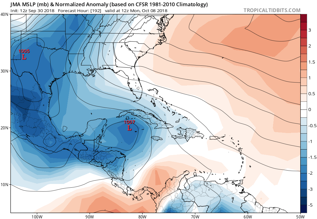
Re: 2018 Tropics: Global Model Runs Discussion (Out to day 16)
JMA shows gradual organization heading north:
0 likes
-
toad strangler
- S2K Supporter
- Posts: 4170
- Joined: Sun Jul 28, 2013 3:09 pm
- Location: Earth
- Contact:
Re: 2018 Tropics: Global Model Runs Discussion (Out to day 16)
12z Euro splits vorticity at 144

0 likes
-
Aric Dunn
- Category 5
- Posts: 21228
- Age: 41
- Joined: Sun Sep 19, 2004 9:58 pm
- Location: Ready for the Chase.
- Contact:
Re: 2018 Tropics: Global Model Runs Discussion (Out to day 16)
and more Gobbledygook..  so we wait now until we have some solid convection for models to latch onto. couple more days.
0 likes
Note: If I make a post that is brief. Please refer back to previous posts for the analysis or reasoning. I do not re-write/qoute what my initial post said each time.
If there is nothing before... then just ask
Space & Atmospheric Physicist, Embry-Riddle Aeronautical University,
I believe the sky is falling...
If there is nothing before... then just ask
Space & Atmospheric Physicist, Embry-Riddle Aeronautical University,
I believe the sky is falling...
-
AutoPenalti
- Category 5
- Posts: 3949
- Age: 27
- Joined: Mon Aug 17, 2015 4:16 pm
- Location: Ft. Lauderdale, Florida
Re: 2018 Tropics: Global Model Runs Discussion (Out to day 16)
We won’t receive consistent runs with these monsoonal gyres until an actual center is formed.
Usually these take their sweet time to produce some form of genesis. These really drive me nuts.
Usually these take their sweet time to produce some form of genesis. These really drive me nuts.
Last edited by AutoPenalti on Sun Sep 30, 2018 1:47 pm, edited 1 time in total.
1 likes
The posts in this forum are NOT official forecasts and should not be used as such. They are just the opinion of the poster and may or may not be backed by sound meteorological data. They are NOT endorsed by any professional institution or STORM2K. For official information, please refer to products from the NHC and NWS.
Model Runs Cheat Sheet:
GFS (5:30 AM/PM, 11:30 AM/PM)
HWRF, GFDL, UKMET, NAVGEM (6:30-8:00 AM/PM, 12:30-2:00 AM/PM)
ECMWF (1:45 AM/PM)
TCVN is a weighted averaged
-
toad strangler
- S2K Supporter
- Posts: 4170
- Joined: Sun Jul 28, 2013 3:09 pm
- Location: Earth
- Contact:
Re: 2018 Tropics: Global Model Runs Discussion (Out to day 16)
Euro 500mb setup closes the Leslie weakness much more than GFS
0 likes
-
cycloneye

- Admin

- Posts: 139308
- Age: 67
- Joined: Thu Oct 10, 2002 10:54 am
- Location: San Juan, Puerto Rico
Re: 2018 Tropics: Global Model Runs Discussion (Out to day 16)
LarryWx wrote:I think there is enough of a threat now to consider starting a new thread addressing early Oct Caribbean potential TC so it doesn’t clutter up this thread. I mean we don’t even have a discussion thread for this yet as the remnants of Kirk thread may not be the best place to discuss it. Opinions?
Meanwhile, I think that one feature that shouldn’t be overlooked is for a residual Leslie trough being left behind for a time south of Bermuda even after she finally moves NE. This residual trough may delay a rebuild of ridging south of Bermuda long enough to maintain a steering influencing weakness there long enough to be the primary reason any Caribbean low may initially lift out E of FL instead of into the Gulf. Remember that it often doesn’t take much of a 500 mb level weakness to attract a TC. Even something as subtle as this can easily do it. Example: Anyone remember Jose’s residual trough off the NE US that was just enough to keep Maria from threatening NC like some models had been showing?
I will consult with the fellow admins about your point of a new thread.As you know,we have the two reasons for a new area of interest thread to be up.
1- Incipient disturbance
2- Mentioned in TWO.
3 likes
Visit the Caribbean-Central America Weather Thread where you can find at first post web cams,radars
and observations from Caribbean basin members Click Here
and observations from Caribbean basin members Click Here
-
Aric Dunn
- Category 5
- Posts: 21228
- Age: 41
- Joined: Sun Sep 19, 2004 9:58 pm
- Location: Ready for the Chase.
- Contact:
Re: 2018 Tropics: Global Model Runs Discussion (Out to day 16)
cycloneye wrote:LarryWx wrote:I think there is enough of a threat now to consider starting a new thread addressing early Oct Caribbean potential TC so it doesn’t clutter up this thread. I mean we don’t even have a discussion thread for this yet as the remnants of Kirk thread may not be the best place to discuss it. Opinions?
Meanwhile, I think that one feature that shouldn’t be overlooked is for a residual Leslie trough being left behind for a time south of Bermuda even after she finally moves NE. This residual trough may delay a rebuild of ridging south of Bermuda long enough to maintain a steering influencing weakness there long enough to be the primary reason any Caribbean low may initially lift out E of FL instead of into the Gulf. Remember that it often doesn’t take much of a 500 mb level weakness to attract a TC. Even something as subtle as this can easily do it. Example: Anyone remember Jose’s residual trough off the NE US that was just enough to keep Maria from threatening NC like some models had been showing?
I will consult with the fellow admins about your point of a new thread.As you know,we have the two reasons for a new area of interest thread to be up.
1- Incipient disturbance
2- Mentioned in TWO.
I would say give it until tomorrow. Once there is some sort of coherent convective mass to track.
3 likes
Note: If I make a post that is brief. Please refer back to previous posts for the analysis or reasoning. I do not re-write/qoute what my initial post said each time.
If there is nothing before... then just ask
Space & Atmospheric Physicist, Embry-Riddle Aeronautical University,
I believe the sky is falling...
If there is nothing before... then just ask
Space & Atmospheric Physicist, Embry-Riddle Aeronautical University,
I believe the sky is falling...
Re: 2018 Tropics: Global Model Runs Discussion (Out to day 16)
12Z Euro 228 just off SE FL in NW Bahamas. Weak. Then moves NNE (stays off FL) as ridging to north starts to weaken. I’d bet that later maps would have recurved it offshore the US as ridging would very likely keep pulling out/weaken. Different scenario of many possibilities.
Last edited by LarryWx on Sun Sep 30, 2018 2:02 pm, edited 4 times in total.
0 likes
Personal Forecast Disclaimer:
The posts in this forum are NOT official forecasts and should not be used as such. They are just the opinion of the poster and may or may not be backed by sound meteorological data. They are NOT endorsed by any professional institution or storm2k.org. For official information, please refer to the NHC and NWS products.
The posts in this forum are NOT official forecasts and should not be used as such. They are just the opinion of the poster and may or may not be backed by sound meteorological data. They are NOT endorsed by any professional institution or storm2k.org. For official information, please refer to the NHC and NWS products.
-
AutoPenalti
- Category 5
- Posts: 3949
- Age: 27
- Joined: Mon Aug 17, 2015 4:16 pm
- Location: Ft. Lauderdale, Florida
Re: 2018 Tropics: Global Model Runs Discussion (Out to day 16)
In my opinion, I would wait until a 5-day outlook is put out... there’s just too many variables at the moment with convection that is yet to materialize.
3 likes
The posts in this forum are NOT official forecasts and should not be used as such. They are just the opinion of the poster and may or may not be backed by sound meteorological data. They are NOT endorsed by any professional institution or STORM2K. For official information, please refer to products from the NHC and NWS.
Model Runs Cheat Sheet:
GFS (5:30 AM/PM, 11:30 AM/PM)
HWRF, GFDL, UKMET, NAVGEM (6:30-8:00 AM/PM, 12:30-2:00 AM/PM)
ECMWF (1:45 AM/PM)
TCVN is a weighted averaged
-
Aric Dunn
- Category 5
- Posts: 21228
- Age: 41
- Joined: Sun Sep 19, 2004 9:58 pm
- Location: Ready for the Chase.
- Contact:
Re: 2018 Tropics: Global Model Runs Discussion (Out to day 16)
not the best .... but this is the EURO simulated satellite through 192hrs.. gives a general idea of the mess the EURO has.

1 likes
Note: If I make a post that is brief. Please refer back to previous posts for the analysis or reasoning. I do not re-write/qoute what my initial post said each time.
If there is nothing before... then just ask
Space & Atmospheric Physicist, Embry-Riddle Aeronautical University,
I believe the sky is falling...
If there is nothing before... then just ask
Space & Atmospheric Physicist, Embry-Riddle Aeronautical University,
I believe the sky is falling...

Re: 2018 Tropics: Global Model Runs Discussion (Out to day 16)
This could be one explanation why it might struggle. Interesting that it splits off from Leslie and dives SW. I would argue that predicting ULL's out 10 days is tricky and sometimes they can help aide with outflow. Like others have mentioned this one will take it's sweet time and we need to be patient.
https://twitter.com/AndyHazelton/status/1046475519951347720
https://twitter.com/AndyHazelton/status/1046475519951347720
1 likes
The following post is NOT an official forecast and should not be used as such. It is just the opinion of the poster and may or may not be backed by sound meteorological data. It is NOT endorsed by any professional institution including storm2k.org For Official Information please refer to the NHC and NWS products.
Who is online
Users browsing this forum: cainjamin, Cpv17, Stratton23, zzzh and 128 guests