


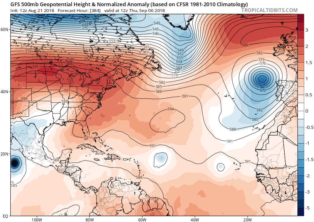
2018 Tropics: Global Model Runs Discussion (Out to day 16)
Moderator: S2k Moderators
Forum rules

The posts in this forum are NOT official forecasts and should not be used as such. They are just the opinion of the poster and may or may not be backed by sound meteorological data. They are NOT endorsed by any professional institution or STORM2K. For official information, please refer to products from the National Hurricane Center and National Weather Service.
-
gatorcane

- S2K Supporter

- Posts: 23499
- Age: 46
- Joined: Sun Mar 13, 2005 3:54 pm
- Location: Boca Raton, FL
Re: 2018 Tropics: Global Model Runs Discussion (Out to day 16)
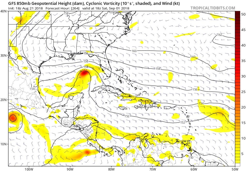
wxGuy wrote:https://www.tropicaltidbits.com/analysis/models/gfs/2018082112/gfs_mslp_uv850_atl_53.png
So obviously take it with a grain of salt but steering as shown by the 16-day GFS, looks ominous with a huge area of high pressure over Southern Canada and northern US with ridging over the subtropical Western Atlantic:
0 likes


Re: 2018 Tropics: Global Model Runs Discussion (Out to day 16)
gatorcane wrote:wxGuy wrote:https://www.tropicaltidbits.com/analysis/models/gfs/2018082112/gfs_mslp_uv850_atl_53.png
So obviously take it with a grain of salt but steering as shown by the 16-day GFS, looks ominous with a huge area of high pressure over Southern Canada and northern US with ridging over the subtropical Western Atlantic:
Where would that cause a hurricane to steer? More to the west?
0 likes
-
stormlover2013
- Category 5

- Posts: 2312
- Joined: Thu Aug 22, 2013 12:06 pm
- Location: Lumberton, Texas
Re: 2018 Tropics: Global Model Runs Discussion (Out to day 16)
stormlover2013 wrote:oh yeah, prob GOM
Thank you. I’m on the upper Texas coast.
0 likes
-
stormlover2013
- Category 5
- Posts: 2312
- Joined: Thu Aug 22, 2013 12:06 pm
- Location: Lumberton, Texas
Re: 2018 Tropics: Global Model Runs Discussion (Out to day 16)
same here but long range models u can't trust them
1 likes
-
gatorcane
- S2K Supporter
- Posts: 23499
- Age: 46
- Joined: Sun Mar 13, 2005 3:54 pm
- Location: Boca Raton, FL
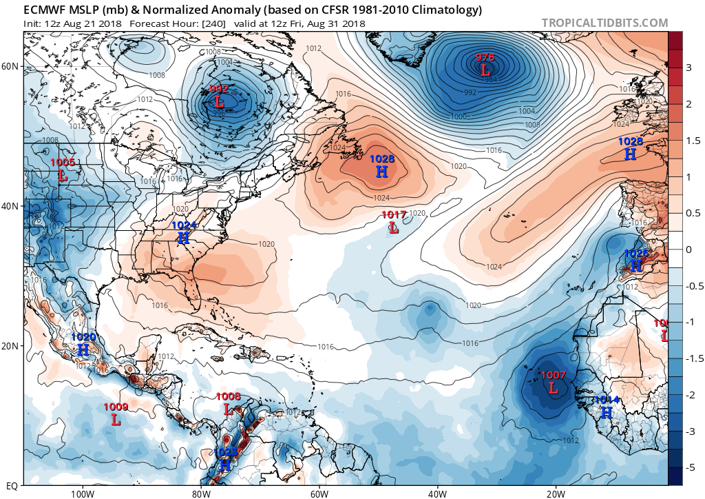
Re: 2018 Tropics: Global Model Runs Discussion (Out to day 16)
12Z ECMWF with a strong area of low pressure near the Cabo Verde islands at 240 hours:
4 likes
-
Hurricane Mike
- Category 2

- Posts: 562
- Joined: Tue Apr 10, 2018 7:44 am
Re: 2018 Tropics: Global Model Runs Discussion (Out to day 16)
gatorcane wrote:wxGuy wrote:https://www.tropicaltidbits.com/analysis/models/gfs/2018082112/gfs_mslp_uv850_atl_53.png
So obviously take it with a grain of salt but steering as shown by the 16-day GFS, looks ominous with a huge area of high pressure over Southern Canada and northern US with ridging over the subtropical Western Atlantic:
Wow talk about a Miami to Corpus-type track setup should anything occur.
2 likes

Re: 2018 Tropics: Global Model Runs Discussion (Out to day 16)
0 likes
The above post is not official and should not be used as such. It is the opinion of the poster and may or may not be backed by sound meteorological data. It is not endorsed by any professional institution or storm2k.org. For official information, please refer to the NHC and NWS products.
Re: 2018 Tropics: Global Model Runs Discussion (Out to day 16)
gatorcane wrote:12Z ECMWF with a strong area of low pressure near the Cabo Verde islands at 240 hours:
Consistent with the 12Z Euro operational, about 20% of the 50 EPS (~10) members have a TC form in the far E MDR ~Sept. 1 moving W to WNW. 4 of those 10 geneses go down to sub 990 mb (i.e., likely hurricanes). By day 15 (9/5), the TCs are mainly between 40W and 50W with some safely recurving N of 20N while others are still between 15N and 20N moving mainly WNW. None of these were on the 0Z EPS.
2 likes
Personal Forecast Disclaimer:
The posts in this forum are NOT official forecasts and should not be used as such. They are just the opinion of the poster and may or may not be backed by sound meteorological data. They are NOT endorsed by any professional institution or storm2k.org. For official information, please refer to the NHC and NWS products.
The posts in this forum are NOT official forecasts and should not be used as such. They are just the opinion of the poster and may or may not be backed by sound meteorological data. They are NOT endorsed by any professional institution or storm2k.org. For official information, please refer to the NHC and NWS products.

-
galaxy401

- Category 5
- Posts: 2298
- Age: 28
- Joined: Sat Aug 25, 2012 9:04 pm
- Location: Casa Grande, Arizona
Re: 2018 Tropics: Global Model Runs Discussion (Out to day 16)
Are models still showing that nontropical storm heading to the Bahamas or did they drop that?
0 likes
Got my eyes on moving right into Hurricane Alley: Florida.
-
AutoPenalti
- Category 5
- Posts: 3949
- Age: 27
- Joined: Mon Aug 17, 2015 4:16 pm
- Location: Ft. Lauderdale, Florida
Re: 2018 Tropics: Global Model Runs Discussion (Out to day 16)
CFS showing a flat ridge but seems to show recurves at day 16. Maybe set up is changing?
0 likes
The posts in this forum are NOT official forecasts and should not be used as such. They are just the opinion of the poster and may or may not be backed by sound meteorological data. They are NOT endorsed by any professional institution or STORM2K. For official information, please refer to products from the NHC and NWS.
Model Runs Cheat Sheet:
GFS (5:30 AM/PM, 11:30 AM/PM)
HWRF, GFDL, UKMET, NAVGEM (6:30-8:00 AM/PM, 12:30-2:00 AM/PM)
ECMWF (1:45 AM/PM)
TCVN is a weighted averaged
Re: 2018 Tropics: Global Model Runs Discussion (Out to day 16)
GFS backing off MDR activity through 264 hours (albeit a tad stronger with the wave in the western MDR) but now has a system in the Gulf.


0 likes
The above post is not official and should not be used as such. It is the opinion of the poster and may or may not be backed by sound meteorological data. It is not endorsed by any professional institution or storm2k.org. For official information, please refer to the NHC and NWS products.
-
gatorcane
- S2K Supporter
- Posts: 23499
- Age: 46
- Joined: Sun Mar 13, 2005 3:54 pm
- Location: Boca Raton, FL
Re: 2018 Tropics: Global Model Runs Discussion (Out to day 16)
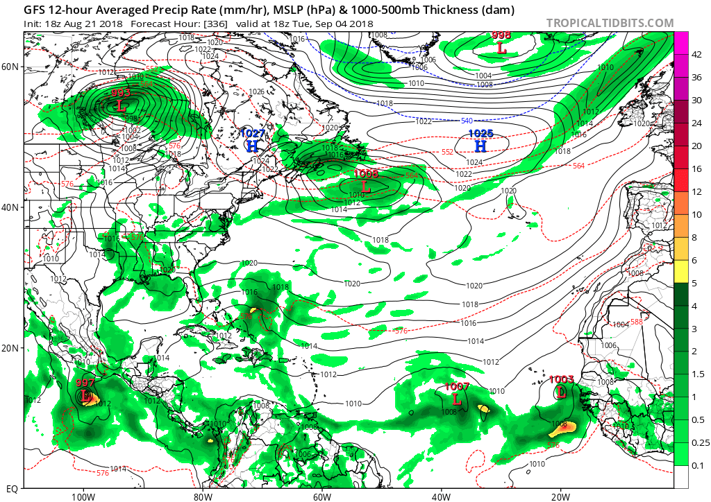
Something in the GOM on 18Z GFS in long-range:
0 likes
-
gatorcane
- S2K Supporter
- Posts: 23499
- Age: 46
- Joined: Sun Mar 13, 2005 3:54 pm
- Location: Boca Raton, FL
Re: 2018 Tropics: Global Model Runs Discussion (Out to day 16)
In the GFS super-long range looks busy:
0 likes
Re: 2018 Tropics: Global Model Runs Discussion (Out to day 16)
GFS showing 05' like path similar to Katrina, Rita watch the looop


0 likes
Re: 2018 Tropics: Global Model Runs Discussion (Out to day 16)
either way tropics are waking up and so are the models 
1 likes

Re: 2018 Tropics: Global Model Runs Discussion (Out to day 16)
Cape Verde season usually starts up around now. The 18z GFS shows 2 lows from origins in that source region. It wouldn’t be a burst per se, but if it was to be right and follow an Eastpac system with a NW Gulf landfall, the 3rd system would likely be east of there. Run goes out to the end of the first week in September which is within a few days of the peak.
2 likes
Who is online
Users browsing this forum: hcane27, Hurricane2022, TheWisestofAll and 107 guests