There is now near unanimous agreement that there will be a tropical low forming in the NW Caribbean about 7 days from now or around 5/24. (This compares to those GFS runs on their own around a week ago that were forming it there around 5/18-19 and turning it into an unrealistic for May cat 2 H later hitting FL on many runs.)
From there, the models have it move northward to or near FL around day 10 (near 5/27). Most models bring it to TS strength then though GFS runs have a cat 1 H. I think TS strength would be more realistic in late May. FL is now clearly at risk for a TS around 5/27 with this model agreement.
2018 Tropics: Global Model Runs Discussion (Out to day 16)
Moderator: S2k Moderators
Forum rules

The posts in this forum are NOT official forecasts and should not be used as such. They are just the opinion of the poster and may or may not be backed by sound meteorological data. They are NOT endorsed by any professional institution or STORM2K. For official information, please refer to products from the National Hurricane Center and National Weather Service.
Re: 2018 Tropics: Global Model Runs Discussion (Out to day 16)
Last edited by LarryWx on Thu May 17, 2018 8:38 am, edited 2 times in total.
2 likes
Personal Forecast Disclaimer:
The posts in this forum are NOT official forecasts and should not be used as such. They are just the opinion of the poster and may or may not be backed by sound meteorological data. They are NOT endorsed by any professional institution or storm2k.org. For official information, please refer to the NHC and NWS products.
The posts in this forum are NOT official forecasts and should not be used as such. They are just the opinion of the poster and may or may not be backed by sound meteorological data. They are NOT endorsed by any professional institution or storm2k.org. For official information, please refer to the NHC and NWS products.
-
gatorcane

- S2K Supporter

- Posts: 23499
- Age: 46
- Joined: Sun Mar 13, 2005 3:54 pm
- Location: Boca Raton, FL
Re: 2018 Tropics: Global Model Runs Discussion (Out to day 16)
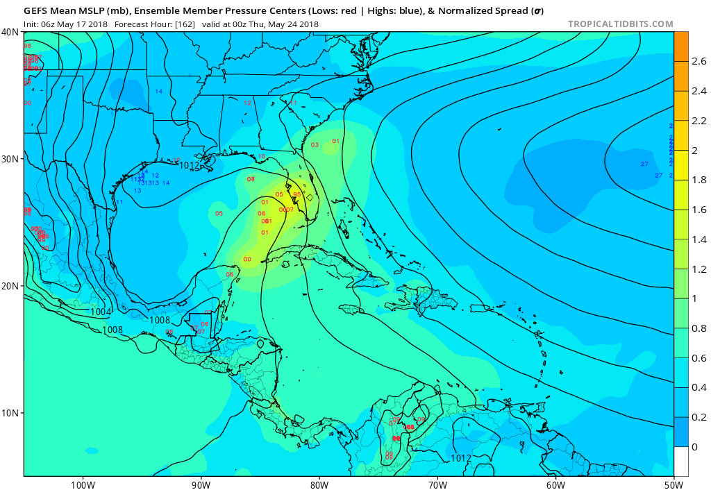
06Z GFS ensembles clustered in the EGOM and west coast of Florida:
1 likes
-
stormlover2013
- Category 5

- Posts: 2312
- Joined: Thu Aug 22, 2013 12:06 pm
- Location: Lumberton, Texas
-
cycloneye

- Admin

- Posts: 139077
- Age: 67
- Joined: Thu Oct 10, 2002 10:54 am
- Location: San Juan, Puerto Rico
Re: 2018 Tropics: Global Model Runs Discussion (Out to day 16)
Ventrice is still skeptic.
@MJVentrice
A bit more credibility for a potential tropical threat over the Gulf of Mexico the weekend of Memorial Day. Still a lot left for the models to resolve, but I cannot overlook the fact that the GEM and ECMWF and in agreement with the GFS now. Still room for change as fcst comes in
@MJVentrice
Even though there's agreement now, I'm still skeptical on the idea of this system developing. It clearly has a more credible shot, but there's a lot of things the models have to get right in order to nail this forecast. Call me a skeptic, but we have hard time in the tropics
@MJVentrice
A bit more credibility for a potential tropical threat over the Gulf of Mexico the weekend of Memorial Day. Still a lot left for the models to resolve, but I cannot overlook the fact that the GEM and ECMWF and in agreement with the GFS now. Still room for change as fcst comes in
@MJVentrice
Even though there's agreement now, I'm still skeptical on the idea of this system developing. It clearly has a more credible shot, but there's a lot of things the models have to get right in order to nail this forecast. Call me a skeptic, but we have hard time in the tropics
0 likes
Visit the Caribbean-Central America Weather Thread where you can find at first post web cams,radars
and observations from Caribbean basin members Click Here
and observations from Caribbean basin members Click Here
-
weathaguyry

- Category 5
- Posts: 1272
- Age: 20
- Joined: Wed Jun 15, 2016 5:16 am
- Location: Long Island, NY
Re: 2018 Tropics: Global Model Runs Discussion (Out to day 16)
The FV3-GFS is the new comedy section of tropical tidbits 
2 likes
My posts are only my opinions and NOT official forecasts. For official forecasts, consult the National Hurricane Center or the National Weather Service.
Irene 11', Sandy 12', Fay 20’, Isaias 20’, Elsa 21’, Henri 21’, Ida 21’
Irene 11', Sandy 12', Fay 20’, Isaias 20’, Elsa 21’, Henri 21’, Ida 21’
-
gatorcane
- S2K Supporter
- Posts: 23499
- Age: 46
- Joined: Sun Mar 13, 2005 3:54 pm
- Location: Boca Raton, FL
Re: 2018 Tropics: Global Model Runs Discussion (Out to day 16)
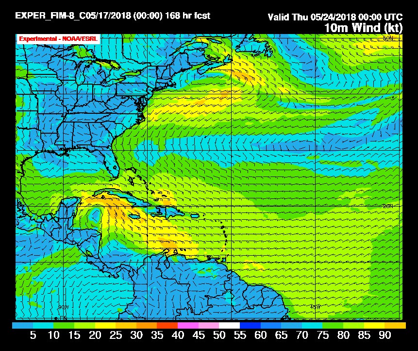
Experimental FIM also shows development in the NW Caribbean, 168 hours below:
0 likes
-
stormlover2013
- Category 5
- Posts: 2312
- Joined: Thu Aug 22, 2013 12:06 pm
- Location: Lumberton, Texas
Re: 2018 Tropics: Global Model Runs Discussion (Out to day 16)
EURO on board then I am almost on board still need a Low to form...just so hard to trust models right now this early on in the season but should be fun to watch the next 2 weeks
0 likes
-
MGC

- S2K Supporter
- Posts: 5792
- Joined: Sun Mar 23, 2003 9:05 pm
- Location: Pass Christian MS, or what is left.
Re: 2018 Tropics: Global Model Runs Discussion (Out to day 16)
weathaguyry wrote:The FV3-GFS is the new comedy section of tropical tidbits
It is.....06Z run has a 933mb cane on Louisiana coast on May 31st.....MGC
3 likes
-
Ivanhater

- Storm2k Moderator

- Posts: 10852
- Age: 37
- Joined: Fri Jul 01, 2005 8:25 am
- Location: Pensacola
Re: 2018 Tropics: Global Model Runs Discussion (Out to day 16)
Storm2k getting an early start this season..hopefully not a sign of what's to come for the 2018 season. This would ruin many folks MDW plans depending where it goes 
1 likes
Michael
-
wxman57

- Moderator-Pro Met

- Posts: 22482
- Age: 66
- Joined: Sat Jun 21, 2003 8:06 pm
- Location: Houston, TX (southwest)
Re: 2018 Tropics: Global Model Runs Discussion (Out to day 16)
MGC wrote:weathaguyry wrote:The FV3-GFS is the new comedy section of tropical tidbits
It is.....06Z run has a 933mb cane on Louisiana coast on May 31st.....MGC
And it sits on the SE Louisiana coast for 2 days as a major hurricane, putting New Orleans underwater. This "upgraded" GFS is going to be interesting...
8 likes
-
chris_fit

- Category 5
- Posts: 3078
- Joined: Wed Sep 10, 2003 11:58 pm
- Location: Tampa Bay Area, FL
- Contact:
Re: 2018 Tropics: Global Model Runs Discussion (Out to day 16)
Anyone know what the FSU SE says?
1 likes
-
NotSparta

- Professional-Met

- Posts: 1648
- Age: 22
- Joined: Fri Aug 18, 2017 8:24 am
- Location: Naples, FL
- Contact:
Re: 2018 Tropics: Global Model Runs Discussion (Out to day 16)
New GFS shows the storm managing to use the subtropical jet as an outflow jet
1 likes
This post was probably an opinion of mine, and in no way is official. Please refer to http://www.hurricanes.gov for official tropical analysis and advisories.
My website, with lots of tropical wx graphics, including satellite and recon: http://cyclonicwx.com
My website, with lots of tropical wx graphics, including satellite and recon: http://cyclonicwx.com
-
PSUHiker31
- Tropical Storm

- Posts: 114
- Joined: Tue Oct 03, 2017 2:36 pm
Re: 2018 Tropics: Global Model Runs Discussion (Out to day 16)
The FV3 is hot garbage as most meteorologists thought when they chose it for the upgrade over the better option.
Of course on the extremely tiny chance it's sniffing something out the other models aren't (I'll give it that the Euro underdid intensity often last year at this range), then I'll eat my words. But I sincerely doubt that will be the case.
Of course on the extremely tiny chance it's sniffing something out the other models aren't (I'll give it that the Euro underdid intensity often last year at this range), then I'll eat my words. But I sincerely doubt that will be the case.
1 likes
Re: 2018 Tropics: Global Model Runs Discussion (Out to day 16)
How could the FV3 even be doing that with the N GOM
not even all that warm? It doesn't make any sense.
not even all that warm? It doesn't make any sense.
3 likes
Personal Forecast Disclaimer:
The posts in this forum are NOT official forecasts and should not be used as such. They are just the opinion of the poster and may or may not be backed by sound meteorological data. They are NOT endorsed by any professional institution or storm2k.org. For official information, please refer to the NHC and NWS products.
The posts in this forum are NOT official forecasts and should not be used as such. They are just the opinion of the poster and may or may not be backed by sound meteorological data. They are NOT endorsed by any professional institution or storm2k.org. For official information, please refer to the NHC and NWS products.
-
NotSparta
- Professional-Met
- Posts: 1648
- Age: 22
- Joined: Fri Aug 18, 2017 8:24 am
- Location: Naples, FL
- Contact:
Re: 2018 Tropics: Global Model Runs Discussion (Out to day 16)
LarryWx wrote:How could the FV3 even be doing that with the N GOM
not even all that warm? It doesn't make any sense.
GoM is warming, especially the N GOM. It might be enhanced by that outflow jet it shows (this would require low environmental shear and little dry air too to become so strong. It is extremely unlikely, and is probably tied to too much convective feedback)
it reminds me of the NAM actually. Does quite well with extratropical wx, but consistently overdoes TCs
1 likes
This post was probably an opinion of mine, and in no way is official. Please refer to http://www.hurricanes.gov for official tropical analysis and advisories.
My website, with lots of tropical wx graphics, including satellite and recon: http://cyclonicwx.com
My website, with lots of tropical wx graphics, including satellite and recon: http://cyclonicwx.com
Re: 2018 Tropics: Global Model Runs Discussion (Out to day 16)
Unlike Irma last year, I'm retired now, so I don't have to remain in South Florida, for this stuff...
When will the current area of disturbed weather be considered an Invest - there's enough weather moving north from Cuba at this time.
Frank
When will the current area of disturbed weather be considered an Invest - there's enough weather moving north from Cuba at this time.
Frank
1 likes
Re: 2018 Tropics: Global Model Runs Discussion (Out to day 16)
LarryWx wrote:How could the FV3 even be doing that with the N GOM
not even all that warm? It doesn't make any sense.
It's very unrealistic in the real world for such an outcome that far north with current SSTs. Unless you were looking a bombing system in the Carib that quickly moved north and merged with the jet stream with some deep trof which is nothing like what the FV3 is showing. It's very difficult to bomb something in the Atlantic even during the heart of the season with much warmer SSTss, no less in May..
In general the model consensus we can all agree is increased Carib moisture into the eastern and Ngulf from WWB coming over from the EPAC which has been the case for the past week now, example the last system.
1 likes
The above post and any post by Ntxw is NOT an official forecast and should not be used as such. It is just the opinion of the poster and may or may not be backed by sound meteorological data. It is NOT endorsed by any professional institution including Storm2k. For official information, please refer to NWS products.
Help support Storm2K!

Re: 2018 Tropics: Global Model Runs Discussion (Out to day 16)
Already a noticeable vortex over the SW Caribbean, looking at the 06z GFS this is the main area of vorticity that it has almost stalled over the next 3-5 days or so before moving over the NW Caribbean mid next week.

0 likes
Re: 2018 Tropics: Global Model Runs Discussion (Out to day 16)
Ntxw wrote:LarryWx wrote:How could the FV3 even be doing that with the N GOM
not even all that warm? It doesn't make any sense.
It's very unrealistic in the real world for such an outcome that far north with current SSTs. Unless you were looking a bombing system in the Carib that quickly moved north and merged with the jet stream with some deep trof which is nothing like what the FV3 is showing. It's very difficult to bomb something in the Atlantic even during the heart of the season with much warmer SSTss, no less in May..
In general the model consensus we can all agree is increased Carib moisture into the eastern and Ngulf from WWB coming over from the EPAC which has been the case for the past week now, example the last system.
looking at the 250mb winds, it seems to be perfectly tapping into the jet stream. Very strong NW outflow jet
1 likes
-
AutoPenalti
- Category 5
- Posts: 3949
- Age: 27
- Joined: Mon Aug 17, 2015 4:16 pm
- Location: Ft. Lauderdale, Florida
Re: 2018 Tropics: Global Model Runs Discussion (Out to day 16)
Until there is some sort of center that models can pinpoint, any future track would be pointless to look at in the long range.
1 likes
The posts in this forum are NOT official forecasts and should not be used as such. They are just the opinion of the poster and may or may not be backed by sound meteorological data. They are NOT endorsed by any professional institution or STORM2K. For official information, please refer to products from the NHC and NWS.
Model Runs Cheat Sheet:
GFS (5:30 AM/PM, 11:30 AM/PM)
HWRF, GFDL, UKMET, NAVGEM (6:30-8:00 AM/PM, 12:30-2:00 AM/PM)
ECMWF (1:45 AM/PM)
TCVN is a weighted averaged
Who is online
Users browsing this forum: Google [Bot], Killjoy12, Lizzytiz1, Orlando_wx, Steve, StPeteMike and 220 guests