
2018 Tropics: Global Model Runs Discussion (Out to day 16)
Moderator: S2k Moderators
Forum rules

The posts in this forum are NOT official forecasts and should not be used as such. They are just the opinion of the poster and may or may not be backed by sound meteorological data. They are NOT endorsed by any professional institution or STORM2K. For official information, please refer to products from the National Hurricane Center and National Weather Service.
-
TheStormExpert

- Category 5

- Posts: 8487
- Age: 30
- Joined: Wed Feb 16, 2011 5:38 pm
- Location: Palm Beach Gardens, FL
Re: 2018 Tropics: Global Model Runs Discussion (Out to day 16)
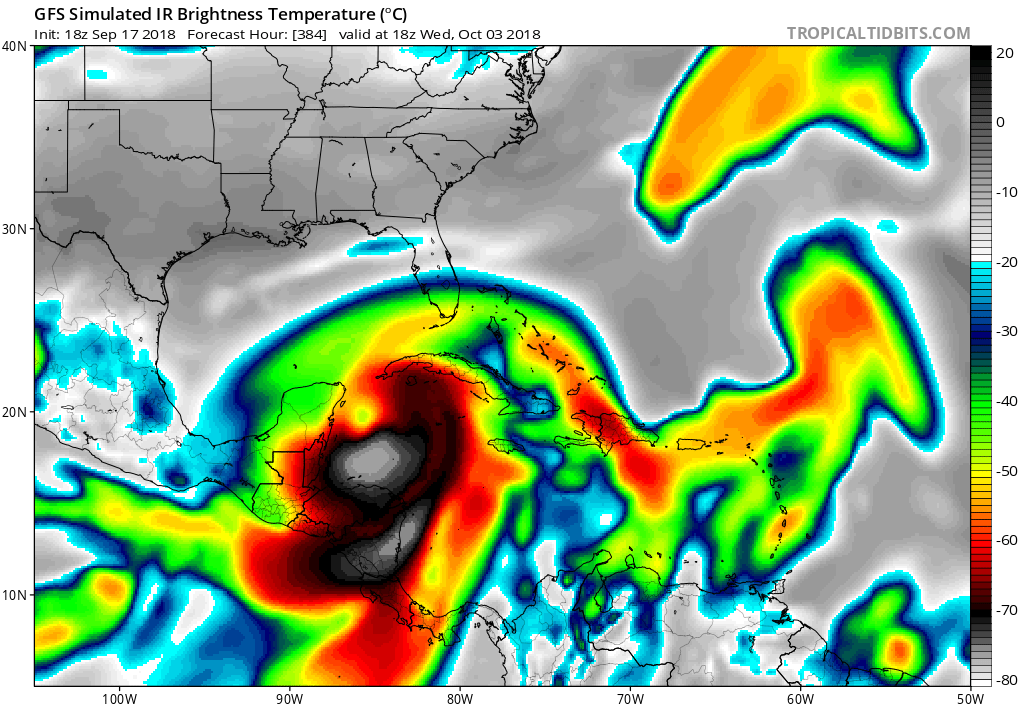
18z FV-3 GFS has a strengthening 982mb hurricane heading north just east of Jamaica @ 384hrs.
0 likes
The following post is NOT an official forecast and should not be used as such. It is just the opinion of the poster and may or may not be backed by sound meteorological data. It is NOT endorsed by storm2k.org.
-
TheStormExpert
- Category 5
- Posts: 8487
- Age: 30
- Joined: Wed Feb 16, 2011 5:38 pm
- Location: Palm Beach Gardens, FL
Re: 2018 Tropics: Global Model Runs Discussion (Out to day 16)
boca wrote:gatorcane wrote:Hurricaneman wrote:Its trying to pull a Wilma on the GFS if you account for truncation. If something that strong happens the Western Caribbean is the place to do it unfortunately
Classic Western Caribbean October monster on simulated IR...thankfully 384 hours out:
But it could be a large storm if it develops, the model expands it as it pulls out of the NW Caribbean:
https://i.postimg.cc/bvkTL36d/gfs_ir_watl_53.png
How do you get that superimposed pic from the GFS model?
On the Tropical Tidbits model page go to the GFS model and under the Upper Dynamics section click Simulated IR Satellite.
0 likes
The following post is NOT an official forecast and should not be used as such. It is just the opinion of the poster and may or may not be backed by sound meteorological data. It is NOT endorsed by storm2k.org.

Re: 2018 Tropics: Global Model Runs Discussion (Out to day 16)
canes92 wrote:What general path do the models show the storms taking? Towards Gulf, TX or FL?
Of course this is way too far out to have even the slightest bit of certainty, but generally speaking, the beginning of October, Texas starts getting cool fronts, slowly closing the door to Texas threats. It does and has happened though, but as we creep closer to October, a Texas threat decreases. Factually, Texas has historically only had two hurricanes between 1900 and 2000 in October.
Last edited by SoupBone on Mon Sep 17, 2018 11:49 pm, edited 1 time in total.
1 likes
Personal Forecast Disclaimer:
The posts in this forum are NOT official forecast and should not be used as such. They are just the opinion of the poster and may or may not be backed by sound meteorological data. They are NOT endorsed by any professional institution or storm2k.org. For official information, please refer to the NHC and NWS products.
The posts in this forum are NOT official forecast and should not be used as such. They are just the opinion of the poster and may or may not be backed by sound meteorological data. They are NOT endorsed by any professional institution or storm2k.org. For official information, please refer to the NHC and NWS products.
-
AutoPenalti
- Category 5
- Posts: 3949
- Age: 27
- Joined: Mon Aug 17, 2015 4:16 pm
- Location: Ft. Lauderdale, Florida
Re: 2018 Tropics: Global Model Runs Discussion (Out to day 16)
Looks like no development on the 00Z but the EPAC now has a major.
EDIT: Actually timing for development has been pushed back, now has a strengthening TS heading NW towards the Cayman Islands and Cuba.
EDIT: Actually timing for development has been pushed back, now has a strengthening TS heading NW towards the Cayman Islands and Cuba.
Last edited by AutoPenalti on Tue Sep 18, 2018 12:46 am, edited 1 time in total.
0 likes
The posts in this forum are NOT official forecasts and should not be used as such. They are just the opinion of the poster and may or may not be backed by sound meteorological data. They are NOT endorsed by any professional institution or STORM2K. For official information, please refer to products from the NHC and NWS.
Model Runs Cheat Sheet:
GFS (5:30 AM/PM, 11:30 AM/PM)
HWRF, GFDL, UKMET, NAVGEM (6:30-8:00 AM/PM, 12:30-2:00 AM/PM)
ECMWF (1:45 AM/PM)
TCVN is a weighted averaged
-
AutoPenalti
- Category 5
- Posts: 3949
- Age: 27
- Joined: Mon Aug 17, 2015 4:16 pm
- Location: Ft. Lauderdale, Florida
Re: 2018 Tropics: Global Model Runs Discussion (Out to day 16)
Growing consensus on something forming in the W. Caribbean moving North.

0 likes
The posts in this forum are NOT official forecasts and should not be used as such. They are just the opinion of the poster and may or may not be backed by sound meteorological data. They are NOT endorsed by any professional institution or STORM2K. For official information, please refer to products from the NHC and NWS.
Model Runs Cheat Sheet:
GFS (5:30 AM/PM, 11:30 AM/PM)
HWRF, GFDL, UKMET, NAVGEM (6:30-8:00 AM/PM, 12:30-2:00 AM/PM)
ECMWF (1:45 AM/PM)
TCVN is a weighted averaged
Re: 2018 Tropics: Global Model Runs Discussion (Out to day 16)
0 likes
Personal Forecast Disclaimer:
The posts in this forum are NOT official forecasts and should not be used as such. They are just the opinion of the poster and may or may not be backed by sound meteorological data. They are NOT endorsed by any professional institution or storm2k.org. For official information, please refer to the NHC and NWS products.
The posts in this forum are NOT official forecasts and should not be used as such. They are just the opinion of the poster and may or may not be backed by sound meteorological data. They are NOT endorsed by any professional institution or storm2k.org. For official information, please refer to the NHC and NWS products.
-
AutoPenalti
- Category 5
- Posts: 3949
- Age: 27
- Joined: Mon Aug 17, 2015 4:16 pm
- Location: Ft. Lauderdale, Florida
Re: 2018 Tropics: Global Model Runs Discussion (Out to day 16)
GFS 06z now has something crossing over from the EPAC and intensifying moving N towards the Florida Keys.
0 likes
The posts in this forum are NOT official forecasts and should not be used as such. They are just the opinion of the poster and may or may not be backed by sound meteorological data. They are NOT endorsed by any professional institution or STORM2K. For official information, please refer to products from the NHC and NWS.
Model Runs Cheat Sheet:
GFS (5:30 AM/PM, 11:30 AM/PM)
HWRF, GFDL, UKMET, NAVGEM (6:30-8:00 AM/PM, 12:30-2:00 AM/PM)
ECMWF (1:45 AM/PM)
TCVN is a weighted averaged
-
SFLcane

- S2K Supporter

- Posts: 9606
- Age: 46
- Joined: Sat Jun 05, 2010 1:44 pm
- Location: Lake Worth Florida
Re: 2018 Tropics: Global Model Runs Discussion (Out to day 16)
06z gfs has a sheared mess over SFL this might be the outcome when it’s all said and done. That’s the hope at least we will take a rainy few days
0 likes
-
toad strangler

- S2K Supporter
- Posts: 4162
- Joined: Sun Jul 28, 2013 3:09 pm
- Location: Earth
- Contact:
Re: 2018 Tropics: Global Model Runs Discussion (Out to day 16)
SFLcane wrote:06z gfs has a sheared mess over SFL this might be the outcome when it’s all said and done. That’s the hope at least we will take a rainy few days
Way too early. But nothing wrong with a little hope lol.
0 likes
-
TheStormExpert
- Category 5
- Posts: 8487
- Age: 30
- Joined: Wed Feb 16, 2011 5:38 pm
- Location: Palm Beach Gardens, FL
Re: 2018 Tropics: Global Model Runs Discussion (Out to day 16)
SFLcane wrote:06z gfs has a sheared mess over SFL this might be the outcome when it’s all said and done. That’s the hope at least we will take a rainy few days
Yeah I can’t help but think we will either see a repeat performance of Hurricane Nate or short-lived TS Philippe from last October.
0 likes
The following post is NOT an official forecast and should not be used as such. It is just the opinion of the poster and may or may not be backed by sound meteorological data. It is NOT endorsed by storm2k.org.
-
toad strangler
- S2K Supporter
- Posts: 4162
- Joined: Sun Jul 28, 2013 3:09 pm
- Location: Earth
- Contact:
Re: 2018 Tropics: Global Model Runs Discussion (Out to day 16)
6z GEFS Ensembles signaling low pressure beginning at 294 hours

0 likes
-
SFLcane
- S2K Supporter
- Posts: 9606
- Age: 46
- Joined: Sat Jun 05, 2010 1:44 pm
- Location: Lake Worth Florida
Re: 2018 Tropics: Global Model Runs Discussion (Out to day 16)
Could very easily end up in the eastern pacific... i understand the pattern is favorable but i'am just not a big fan of 200+hr models especially the bias the gfs has with the caribbean at this time of the year. We shall see
0 likes


Re: 2018 Tropics: Global Model Runs Discussion (Out to day 16)
Would this be the K storm? It's been woefully hot on the northern gulf coast. Heat index stays at about 106. Could use some rain in Biloxi just to cool down.
0 likes
-
gatorcane

- S2K Supporter
- Posts: 23499
- Age: 46
- Joined: Sun Mar 13, 2005 3:54 pm
- Location: Boca Raton, FL
Re: 2018 Tropics: Global Model Runs Discussion (Out to day 16)
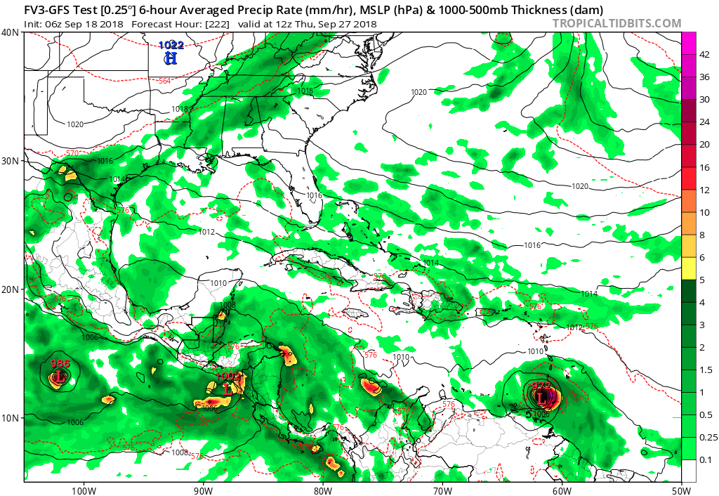
FV3 GFS with a hurricane into the Southern Lesser Antilles:
1 likes
-
toad strangler
- S2K Supporter
- Posts: 4162
- Joined: Sun Jul 28, 2013 3:09 pm
- Location: Earth
- Contact:
Re: 2018 Tropics: Global Model Runs Discussion (Out to day 16)
Just for laughs really, the 6z GFS has a cyclone in the same spot as the 6z FV3-GFS at 384 hours off the SE US coast BUT from completely different origins LOL
GFS brings up a system from the SW Caribbean and the FV-3 brings in a African system from the E
GFS brings up a system from the SW Caribbean and the FV-3 brings in a African system from the E
2 likes
-
SouthFLTropics

- Category 5
- Posts: 4156
- Age: 48
- Joined: Thu Aug 14, 2003 8:04 am
- Location: Port St. Lucie, Florida
Re: 2018 Tropics: Global Model Runs Discussion (Out to day 16)
That 06z FV3 is eerily reminiscent of Matthew. I think it's becoming very clear that the Caribbean is going to have to be closely monitored beginning midweek next week.
0 likes
Fourth Generation Floridian...With lots of storm knowledge passed down from my elders...
Personal Storm History: David 79, Andrew 92, Erin 95, Floyd 99, Irene 99, Frances 04, Jeanne 04, Wilma 05, Matthew 16, Irma 17
Personal Storm History: David 79, Andrew 92, Erin 95, Floyd 99, Irene 99, Frances 04, Jeanne 04, Wilma 05, Matthew 16, Irma 17
-
Emmett_Brown

- Category 5
- Posts: 1343
- Joined: Wed Aug 24, 2005 9:10 pm
- Location: Sarasota FL
Re: 2018 Tropics: Global Model Runs Discussion (Out to day 16)
Climatologically it would make sense for at least 1-2 more Cape Verde storms to form before it all shuts down. So the FV3 seems reasonable.
0 likes
-
CyclonicFury

- Category 5
- Posts: 1970
- Age: 25
- Joined: Sun Jul 02, 2017 12:32 pm
- Location: NC
- Contact:
Re: 2018 Tropics: Global Model Runs Discussion (Out to day 16)
Emmett_Brown wrote:Climatologically it would make sense for at least 1-2 more Cape Verde storms to form before it all shuts down. So the FV3 seems reasonable.
Euro also shows a weak MDR storm at the end of the run. The unreliable CMC shows two but it should not be taken seriously. MDR development in the last 10 days of September is not as rare as one might think, so it's certainly possible we squeeze out one more named storm from the MDR.
Last edited by CyclonicFury on Tue Sep 18, 2018 10:09 am, edited 1 time in total.
0 likes
NCSU B.S. in Meteorology Class of 2021. Tropical weather blogger at http://www.cyclonicfury.com. My forecasts and thoughts are NOT official, for official forecasts please consult the National Hurricane Center.
-
Emmett_Brown
- Category 5
- Posts: 1343
- Joined: Wed Aug 24, 2005 9:10 pm
- Location: Sarasota FL
Re: 2018 Tropics: Global Model Runs Discussion (Out to day 16)
CyclonicFury wrote:Emmett_Brown wrote:Climatologically it would make sense for at least 1-2 more Cape Verde storms to form before it all shuts down. So the FV3 seems reasonable.
Euro also shows a weak MDR storm at the end of the run. The unreliable CMC shows two but it should not be taken seriously. MDR development in the last 10 days of September is not as rare as one night think, so it's certainly possible we squeeze out one more named storm from the MDR.
The FV3 shows the wave (that it later develops) moving off of Africa in about 72 hours at a very low latitude, looks below 10N. Plenty of warm water there too.
0 likes
Re: 2018 Tropics: Global Model Runs Discussion (Out to day 16)
Emmett_Brown wrote:CyclonicFury wrote:Emmett_Brown wrote:Climatologically it would make sense for at least 1-2 more Cape Verde storms to form before it all shuts down. So the FV3 seems reasonable.
Euro also shows a weak MDR storm at the end of the run. The unreliable CMC shows two but it should not be taken seriously. MDR development in the last 10 days of September is not as rare as one night think, so it's certainly possible we squeeze out one more named storm from the MDR.
The FV3 shows the wave (that it later develops) moving off of Africa in about 72 hours at a very low latitude, looks below 10N. Plenty of warm water there too.
So, this is a much earlier wave than the one the Euro/EPS has been developing just off Africa near 9/25. This run ends on 10/4 with a H recurving NNE near 30N, 75W. Climowise, this FV3 scenario is quite possible.
0 likes
Personal Forecast Disclaimer:
The posts in this forum are NOT official forecasts and should not be used as such. They are just the opinion of the poster and may or may not be backed by sound meteorological data. They are NOT endorsed by any professional institution or storm2k.org. For official information, please refer to the NHC and NWS products.
The posts in this forum are NOT official forecasts and should not be used as such. They are just the opinion of the poster and may or may not be backed by sound meteorological data. They are NOT endorsed by any professional institution or storm2k.org. For official information, please refer to the NHC and NWS products.
Who is online
Users browsing this forum: NotSparta and 40 guests