2018 Tropics: Global Model Runs Discussion (Out to day 16)
Moderator: S2k Moderators
Forum rules

The posts in this forum are NOT official forecasts and should not be used as such. They are just the opinion of the poster and may or may not be backed by sound meteorological data. They are NOT endorsed by any professional institution or STORM2K. For official information, please refer to products from the National Hurricane Center and National Weather Service.
-
wxman57

- Moderator-Pro Met

- Posts: 22480
- Age: 66
- Joined: Sat Jun 21, 2003 8:06 pm
- Location: Houston, TX (southwest)
Re: 2018 Tropics: Global Model Runs Discussion (Out to day 16)
00Z Euro has what looks like a frontal low east of Delaware Wednesday night. Good chance a weak low may form, but it may not get classified as a TS or STS, which is why the NHC isn't mentioning it.
2 likes
-
CyclonicFury

- Category 5

- Posts: 1971
- Age: 25
- Joined: Sun Jul 02, 2017 12:32 pm
- Location: NC
- Contact:
Re: 2018 Tropics: Global Model Runs Discussion (Out to day 16)
Still no mention on 2 PM TWO. 12z UKMET text output indicates a weak TC. CMC appears to start the system tropical before becoming extratropical. ICON looks more extratropical. GFS continues to show nothing other than some disorganized vorticity.
0 likes
NCSU B.S. in Meteorology Class of 2021. Tropical weather blogger at http://www.cyclonicfury.com. My forecasts and thoughts are NOT official, for official forecasts please consult the National Hurricane Center.
-
wxman57
- Moderator-Pro Met
- Posts: 22480
- Age: 66
- Joined: Sat Jun 21, 2003 8:06 pm
- Location: Houston, TX (southwest)
Re: 2018 Tropics: Global Model Runs Discussion (Out to day 16)
12Z EC develops what looks like too strong of a low as it exits the Outer Banks Wednesday morning but then quickly weakens it and merges it with a cold front by 12z Thursday. NHC is still not mentioning it, so it's unlikely they will bother with it.
0 likes
-
CyclonicFury
- Category 5
- Posts: 1971
- Age: 25
- Joined: Sun Jul 02, 2017 12:32 pm
- Location: NC
- Contact:
Re: 2018 Tropics: Global Model Runs Discussion (Out to day 16)
wxman57 wrote:12Z EC develops what looks like too strong of a low as it exits the Outer Banks Wednesday morning but then quickly weakens it and merges it with a cold front by 12z Thursday. NHC is still not mentioning it, so it's unlikely they will bother with it.
NHC could be waiting until the system exits the U.S. east coast, like they did with Claudette in 2015.
0 likes
NCSU B.S. in Meteorology Class of 2021. Tropical weather blogger at http://www.cyclonicfury.com. My forecasts and thoughts are NOT official, for official forecasts please consult the National Hurricane Center.
-
cycloneye

- Admin

- Posts: 139027
- Age: 67
- Joined: Thu Oct 10, 2002 10:54 am
- Location: San Juan, Puerto Rico
Re: 2018 Tropics: Global Model Runs Discussion (Out to day 16)
Folks,sit back,relax and enjoy the show that EPAC will put on in the next couple of weeks. We will have things in Atlantic to track when the meat of season comes.
7 likes
Visit the Caribbean-Central America Weather Thread where you can find at first post web cams,radars
and observations from Caribbean basin members Click Here
and observations from Caribbean basin members Click Here

Re: 2018 Tropics: Global Model Runs Discussion (Out to day 16)
cycloneye wrote:Folks,sit back,relax and enjoy the show that EPAC will put on in the next couple of weeks. We will have things in Atlantic to track when the meat of season comes.
Or not, fingers crossed.
4 likes
Personal Forecast Disclaimer:
The posts in this forum are NOT official forecast and should not be used as such. They are just the opinion of the poster and may or may not be backed by sound meteorological data. They are NOT endorsed by any professional institution or storm2k.org. For official information, please refer to the NHC and NWS products.
The posts in this forum are NOT official forecast and should not be used as such. They are just the opinion of the poster and may or may not be backed by sound meteorological data. They are NOT endorsed by any professional institution or storm2k.org. For official information, please refer to the NHC and NWS products.
-
cycloneye
- Admin
- Posts: 139027
- Age: 67
- Joined: Thu Oct 10, 2002 10:54 am
- Location: San Juan, Puerto Rico
Re: 2018 Tropics: Global Model Runs Discussion (Out to day 16)
Expect delays in runs tonight.
@TropicalTidbits
Model delays expected tonight due to partial shutdown of NOAA supercomputer. The full extent of the delays is not yet known.
https://twitter.com/TropicalTidbits/status/1011402043884560384
@TropicalTidbits
Model delays expected tonight due to partial shutdown of NOAA supercomputer. The full extent of the delays is not yet known.
https://twitter.com/TropicalTidbits/status/1011402043884560384
0 likes
Visit the Caribbean-Central America Weather Thread where you can find at first post web cams,radars
and observations from Caribbean basin members Click Here
and observations from Caribbean basin members Click Here
-
cycloneye
- Admin
- Posts: 139027
- Age: 67
- Joined: Thu Oct 10, 2002 10:54 am
- Location: San Juan, Puerto Rico
Re: 2018 Tropics: Global Model Runs Discussion (Out to day 16)
That was fast.
@TropicalTidbits
NOAA operations are back to normal.
https://twitter.com/TropicalTidbits/status/1011428187413282816
@TropicalTidbits
NOAA operations are back to normal.
https://twitter.com/TropicalTidbits/status/1011428187413282816
2 likes
Visit the Caribbean-Central America Weather Thread where you can find at first post web cams,radars
and observations from Caribbean basin members Click Here
and observations from Caribbean basin members Click Here

Re: 2018 Tropics: Global Model Runs Discussion (Out to day 16)
Thank goodness. Some of us are waiting on more runs of the big EPAC hurricanes to see how low they go.
7 likes
The above post and any post by Ntxw is NOT an official forecast and should not be used as such. It is just the opinion of the poster and may or may not be backed by sound meteorological data. It is NOT endorsed by any professional institution including Storm2k. For official information, please refer to NWS products.
Help support Storm2K!
-
CyclonicFury
- Category 5
- Posts: 1971
- Age: 25
- Joined: Sun Jul 02, 2017 12:32 pm
- Location: NC
- Contact:
Re: 2018 Tropics: Global Model Runs Discussion (Out to day 16)
00z ICON barely develops the potential east coast system.
0 likes
NCSU B.S. in Meteorology Class of 2021. Tropical weather blogger at http://www.cyclonicfury.com. My forecasts and thoughts are NOT official, for official forecasts please consult the National Hurricane Center.

Re: 2018 Tropics: Global Model Runs Discussion (Out to day 16)
Decent wave rolling past the CV Islands on Wednesday.

0 likes
-
cycloneye
- Admin
- Posts: 139027
- Age: 67
- Joined: Thu Oct 10, 2002 10:54 am
- Location: San Juan, Puerto Rico
Re: 2018 Tropics: Global Model Runs Discussion (Out to day 16)
Note= You can post the model runs for the off North Carolina coast area on the new thread.
viewtopic.php?f=31&t=119656&p=2682780#p2682780
viewtopic.php?f=31&t=119656&p=2682780#p2682780
1 likes
Visit the Caribbean-Central America Weather Thread where you can find at first post web cams,radars
and observations from Caribbean basin members Click Here
and observations from Caribbean basin members Click Here
-
gatorcane

- S2K Supporter

- Posts: 23499
- Age: 46
- Joined: Sun Mar 13, 2005 3:54 pm
- Location: Boca Raton, FL
Re: 2018 Tropics: Global Model Runs Discussion (Out to day 16)
A bit further south and we could be talking TS or maybe more in northern Gulf. The GFS has it hugging coastline heading west:
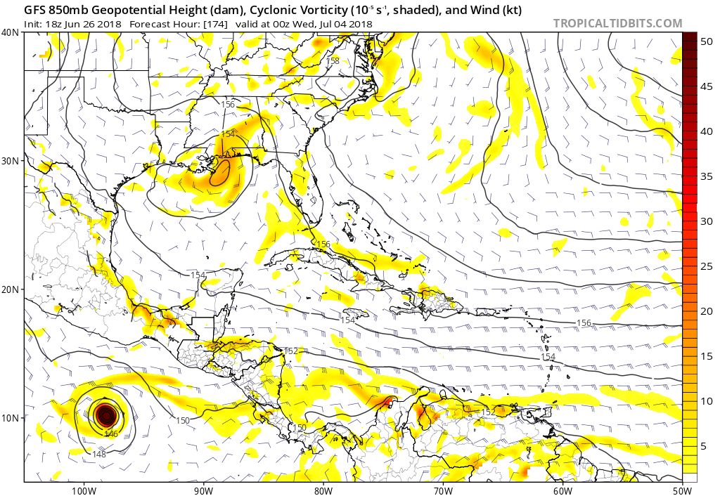
1 likes
-
Dean4Storms
- S2K Supporter
- Posts: 6355
- Age: 61
- Joined: Sun Aug 31, 2003 1:01 pm
- Location: Miramar Bch. FL
Re: 2018 Tropics: Global Model Runs Discussion (Out to day 16)
gatorcane wrote:A bit further south and we could be talking TS or maybe more in northern Gulf. The GFS has it hugging coastline heading west:
ECM EPS has close to 50% shot at Tropical Depression forming in the same general area of the upper central Gulf Coast from the 2nd thru the 4th.
3 likes

Re: 2018 Tropics: Global Model Runs Discussion (Out to day 16)
0Z high res EC has a TS moving into Texas next week
2 likes
-
TheStormExpert

- Category 5
- Posts: 8487
- Age: 30
- Joined: Wed Feb 16, 2011 5:38 pm
- Location: Palm Beach Gardens, FL
Re: 2018 Tropics: Global Model Runs Discussion (Out to day 16)
Alyono wrote:0Z high res has a TS moving into Texas next week
What model?
0 likes
The following post is NOT an official forecast and should not be used as such. It is just the opinion of the poster and may or may not be backed by sound meteorological data. It is NOT endorsed by storm2k.org.
Re: 2018 Tropics: Global Model Runs Discussion (Out to day 16)
Alyono wrote:0Z high res has a TS moving into Texas next week
 Pics? BTW, this site has some strange emoticons.
0 likes
Personal Forecast Disclaimer:
The posts in this forum are NOT official forecast and should not be used as such. They are just the opinion of the poster and may or may not be backed by sound meteorological data. They are NOT endorsed by any professional institution or storm2k.org. For official information, please refer to the NHC and NWS products.
The posts in this forum are NOT official forecast and should not be used as such. They are just the opinion of the poster and may or may not be backed by sound meteorological data. They are NOT endorsed by any professional institution or storm2k.org. For official information, please refer to the NHC and NWS products.
-
TheStormExpert
- Category 5
- Posts: 8487
- Age: 30
- Joined: Wed Feb 16, 2011 5:38 pm
- Location: Palm Beach Gardens, FL
Re: 2018 Tropics: Global Model Runs Discussion (Out to day 16)
3 likes
The following post is NOT an official forecast and should not be used as such. It is just the opinion of the poster and may or may not be backed by sound meteorological data. It is NOT endorsed by storm2k.org.
-
wxman57
- Moderator-Pro Met
- Posts: 22480
- Age: 66
- Joined: Sat Jun 21, 2003 8:06 pm
- Location: Houston, TX (southwest)
Re: 2018 Tropics: Global Model Runs Discussion (Out to day 16)
12Z EC is much weaker with the northern Gulf disturbance next week. Just a bit of rain. No TS development. Closer to what the GFS is predicting. Rainy 4th of July for SE TX, perhaps. Here's a side-by-side comparison:

1 likes
-
wxman57
- Moderator-Pro Met
- Posts: 22480
- Age: 66
- Joined: Sat Jun 21, 2003 8:06 pm
- Location: Houston, TX (southwest)
Re: 2018 Tropics: Global Model Runs Discussion (Out to day 16)
Quite a bit less rain for Texas, too. Instead of over a foot of rain near San Antonio, perhaps a quarter inch.

1 likes
Who is online
Users browsing this forum: bird, cajungal, cycloneye, Yellow Evan and 145 guests