70% chance of TD development late this weekend off the Florida East Coast per the 00z EPS.
https://twitter.com/hurrtrackerapp/status/1006877016820539393
2018 Tropics: Global Model Runs Discussion (Out to day 16)
Moderator: S2k Moderators
Forum rules

The posts in this forum are NOT official forecasts and should not be used as such. They are just the opinion of the poster and may or may not be backed by sound meteorological data. They are NOT endorsed by any professional institution or STORM2K. For official information, please refer to products from the National Hurricane Center and National Weather Service.
-
TheStormExpert

- Category 5

- Posts: 8487
- Age: 30
- Joined: Wed Feb 16, 2011 5:38 pm
- Location: Palm Beach Gardens, FL
Re: 2018 Tropics: Global Model Runs Discussion (Out to day 16)
2 likes
The following post is NOT an official forecast and should not be used as such. It is just the opinion of the poster and may or may not be backed by sound meteorological data. It is NOT endorsed by storm2k.org.

Re: 2018 Tropics: Global Model Runs Discussion (Out to day 16)
^^
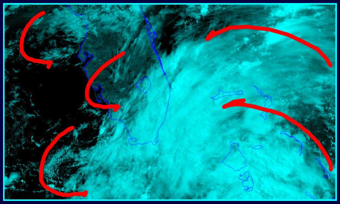
GFS brought something up almost due north out of the Caribbean following 91L (was the 8 day range yesterday or Monday). The EC and CMC look to spin something up off the SE FL Coast. Despite it being early in the season still, this is likely to swing through the state and propagate west rather than hooking off to the ENE or NE and just going out to see. Looks like a mid-latitude ridge to block whatever forms, so that would probably have to come into the Gulf - probably through the Florida Peninsula.
GFS brought something up almost due north out of the Caribbean following 91L (was the 8 day range yesterday or Monday). The EC and CMC look to spin something up off the SE FL Coast. Despite it being early in the season still, this is likely to swing through the state and propagate west rather than hooking off to the ENE or NE and just going out to see. Looks like a mid-latitude ridge to block whatever forms, so that would probably have to come into the Gulf - probably through the Florida Peninsula.
0 likes
-
TheStormExpert
- Category 5
- Posts: 8487
- Age: 30
- Joined: Wed Feb 16, 2011 5:38 pm
- Location: Palm Beach Gardens, FL
Re: 2018 Tropics: Global Model Runs Discussion (Out to day 16)
0 likes
The following post is NOT an official forecast and should not be used as such. It is just the opinion of the poster and may or may not be backed by sound meteorological data. It is NOT endorsed by storm2k.org.
-
crownweather

- S2K Supporter

- Posts: 575
- Age: 49
- Joined: Sat Aug 12, 2006 9:21 am
- Location: Sturbridge, Massachusetts
- Contact:
Re: 2018 Tropics: Global Model Runs Discussion (Out to day 16)
Want to add to my tweet. I also want to see if the European model continues to forecast this scenario in future forecast runs. Just last week, one run of the European model forecasted a TC spinning up between the SC coast and the FL Panhandle and then it ended up dropping it in the very next run. Also, should note that it's forecast from that 1 run never panned out.
As it has been mentioned here on this board, the European model is not the end all, be all in forecasting. It can be way off too.
0 likes
Rob Lightbown
Crown Weather Services
https://crownweather.com
Crown Weather Services
https://crownweather.com
Re: 2018 Tropics: Global Model Runs Discussion (Out to day 16)
No it's not. But I think you have to start looking in that area in the 3-5 day range as 91L moves west into the BoC. That's where the next pile up of energy would be in the pattern if a 4th disturbed area came out of it.
0 likes
-
Dean4Storms
- S2K Supporter
- Posts: 6355
- Age: 61
- Joined: Sun Aug 31, 2003 1:01 pm
- Location: Miramar Bch. FL
-
Dean4Storms
- S2K Supporter
- Posts: 6355
- Age: 61
- Joined: Sun Aug 31, 2003 1:01 pm
- Location: Miramar Bch. FL
Re: 2018 Tropics: Global Model Runs Discussion (Out to day 16)
crownweather wrote:
Want to add to my tweet. I also want to see if the European model continues to forecast this scenario in future forecast runs. Just last week, one run of the European model forecasted a TC spinning up between the SC coast and the FL Panhandle and then it ended up dropping it in the very next run. Also, should note that it's forecast from that 1 run never panned out.
As it has been mentioned here on this board, the European model is not the end all, be all in forecasting. It can be way off too.
Yea I remember that one but in honesty that Low formed over North FL instead. It had the idea but in the wrong location if memory serves. But you're dead on, need more than just one output with this latest scenario.
0 likes
-
gatorcane

- S2K Supporter
- Posts: 23499
- Age: 46
- Joined: Sun Mar 13, 2005 3:54 pm
- Location: Boca Raton, FL
Re: 2018 Tropics: Global Model Runs Discussion (Out to day 16)
That 00Z ECMWF run of a TD off the FL east coast this weekend is highly suspect. The GFS nor UKMET show this not to mention the ECMWF has done this before recently as some posts mention above.
0 likes
-
Clearcloudz

- Category 2

- Posts: 523
- Joined: Sun Jun 10, 2018 1:46 pm
- Location: Rosenberg TX
-
Clearcloudz
- Category 2
- Posts: 523
- Joined: Sun Jun 10, 2018 1:46 pm
- Location: Rosenberg TX
Re: 2018 Tropics: Global Model Runs Discussion (Out to day 16)
gatorcane wrote:That 00Z ECMWF run of a TD off the FL east coast this weekend is highly suspect. The GFS nor UKMET show this not to mention the ECMWF has done this before recently as some posts mention above.
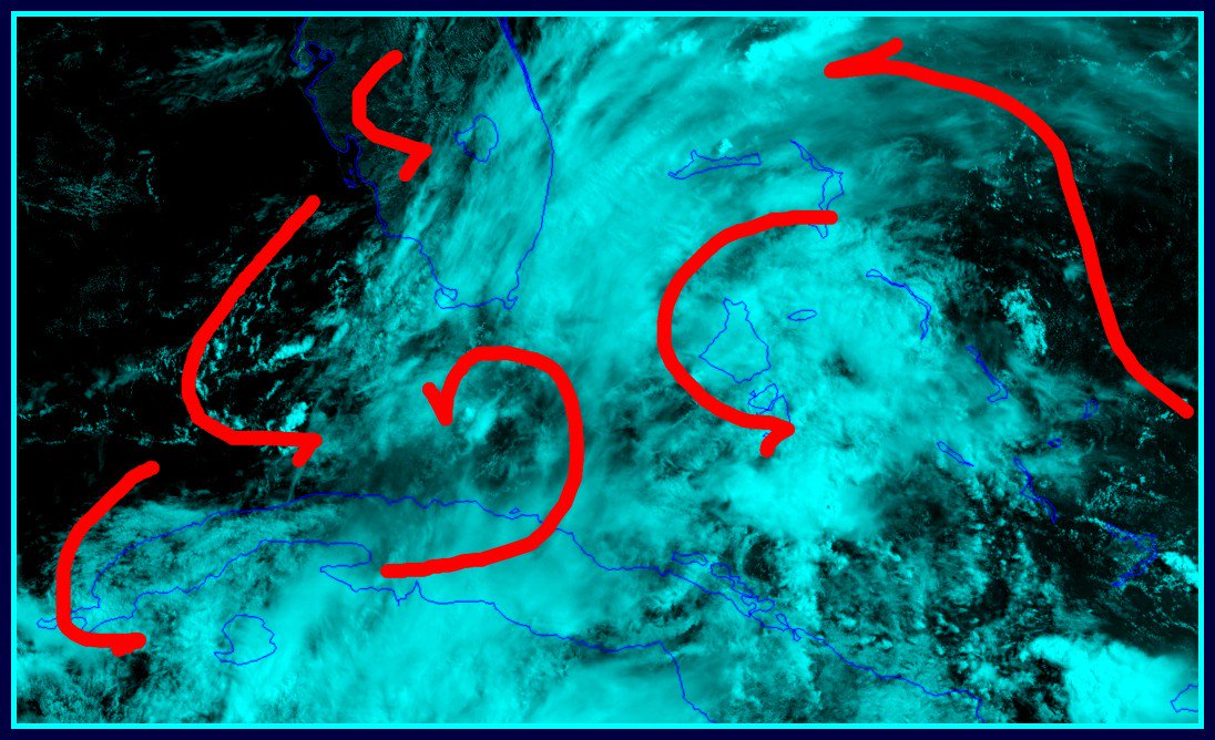
Joe B is laying the chips down for it. Also, the CMC sort of indicates what is likely to happen though it might be too slow. Look at the big ridge over the SE US. You always look south of those for potential development anyway regardless of whether the origin is a piece of a trough, tropical wave, piled up energy or whatever.
https://www.tropicaltidbits.com/analysi ... 300&fh=240
0 likes

Re: 2018 Tropics: Global Model Runs Discussion (Out to day 16)
I'm seeing a little model bias here.
GFS consistently predicting genesis for a solid week and everyone wrote it off. Euro spools something up off the east coast of Florida for one run and that's all that's necessary, apparently.
Let's wait a second to at least get a couple more runs in guys and gals, EURO isn't perfect either
GFS consistently predicting genesis for a solid week and everyone wrote it off. Euro spools something up off the east coast of Florida for one run and that's all that's necessary, apparently.
Let's wait a second to at least get a couple more runs in guys and gals, EURO isn't perfect either
2 likes
Re: 2018 Tropics: Global Model Runs Discussion (Out to day 16)
jfk08c wrote:I'm seeing a little model bias here.
GFS consistently predicting genesis for a solid week and everyone wrote it off. Euro spools something up off the east coast of Florida for one run and that's all that's necessary, apparently.
Let's wait a second to at least get a couple more runs in guys and gals, EURO isn't perfect either
Run the GFS at 500mb, and you'll see an upper pattern evolution that mirrors what the CMC is doing. It just doesn't have the surface feature yet.
0 likes
-
Clearcloudz
- Category 2
- Posts: 523
- Joined: Sun Jun 10, 2018 1:46 pm
- Location: Rosenberg TX
Re: 2018 Tropics: Global Model Runs Discussion (Out to day 16)
Invest 92L will be issued sometime today.
1 likes


Re: 2018 Tropics: Global Model Runs Discussion (Out to day 16)
Looks like the GFS has the low, but it’s caught over Alabama / Georgia rather than getting pushed out to the Atlantic.
1 likes

Re: 2018 Tropics: Global Model Runs Discussion (Out to day 16)
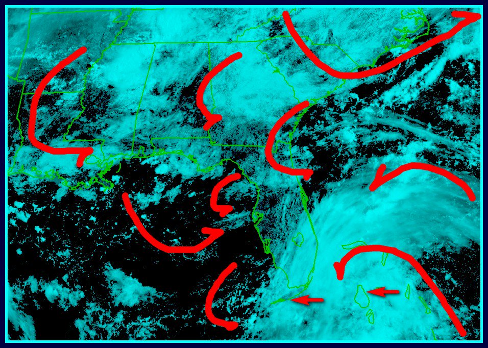
Both CMC and Euro develop the vorticity over central Georgia in 72 hrs - associated with a trough of low pressure from a back door cold front. They then dive it south and southeast off the NE FL coast by 96 hrs. So it appears its mid-latitude energy that spins this system up - perhaps an MCS helps it get going at the surface. Seems unlikely but we'll see if future model runs continue it. The ECM does have a tendency to develop these frontal-type systems into overdone cyclones.
https://www.tropicaltidbits.com/analysis/models/?model=ecmwf®ion=seus&pkg=uv850_vort&runtime=2018061300&fh=72
https://www.tropicaltidbits.com/analysis/models/?model=ecmwf®ion=seus&pkg=uv850_vort&runtime=2018061300&fh=72
1 likes
Re: 2018 Tropics: Global Model Runs Discussion (Out to day 16)
ronjon wrote:Both CMC and Euro develop the vorticity over central Georgia in 72 hrs - associated with a trough of low pressure from a back door cold front. They then dive it south and southeast off the NE FL coast by 96 hrs. So it appears its mid-latitude energy that spins this system up - perhaps an MCS helps it get going at the surface. Seems unlikely but we'll see if future model runs continue it. The ECM does have a tendency to develop these frontal-type systems into overdone cyclones.
https://www.tropicaltidbits.com/analysis/models/?model=ecmwf®ion=seus&pkg=uv850_vort&runtime=2018061300&fh=72
CMC (at 850mb) looks like it wants to repeat the pattern with the run ending with another MCS near the SE US Coast at the end of the run. It's an interesting year with the way the water temperature profiles are. It may well be that we get a couple in-land systems to spin up once offshore this season.
1 likes
-
wxman57

- Moderator-Pro Met

- Posts: 22480
- Age: 66
- Joined: Sat Jun 21, 2003 8:06 pm
- Location: Houston, TX (southwest)
Re: 2018 Tropics: Global Model Runs Discussion (Out to day 16)
Looks like a phantom storm. Upper-air not too favorable for development.
6 likes
Re: 2018 Tropics: Global Model Runs Discussion (Out to day 16)
12z GFS and CMC are even further inland with this energy, so seems unlikely that the Euro will maintain its solution.
1 likes
Re: 2018 Tropics: Global Model Runs Discussion (Out to day 16)
ForexTidbits wrote:EURO Model coming out with a homegrown tropical System off the east coast of Florida. Needs to be watched as potential is there for something to form quickly since it is inside the 5 day window on the EURO.
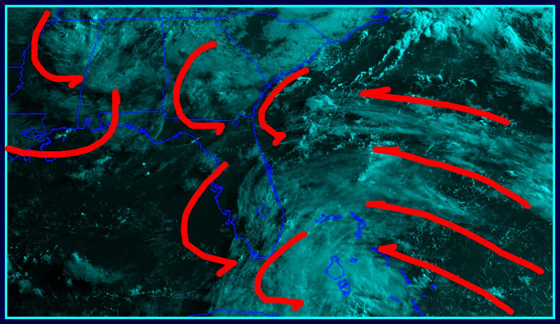
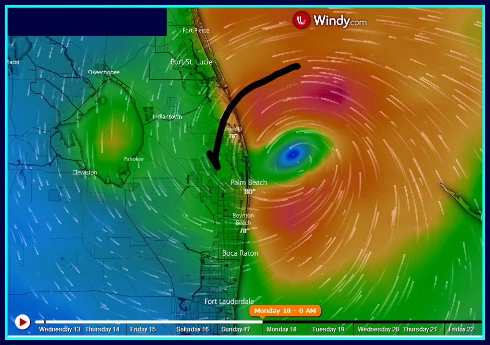
The 0Z Euro develops it a mere 25 miles offshore while moving south! Sorry, but I’m having a very hard time believing this. The Euro has had its share of overdeveloping, especially north of 25N. This one is ridiculous. I’m calling bogus on this if the track is this close to the coast.
Edit: Was this BB down for a number of hours earlier today?
2 likes
Personal Forecast Disclaimer:
The posts in this forum are NOT official forecasts and should not be used as such. They are just the opinion of the poster and may or may not be backed by sound meteorological data. They are NOT endorsed by any professional institution or storm2k.org. For official information, please refer to the NHC and NWS products.
The posts in this forum are NOT official forecasts and should not be used as such. They are just the opinion of the poster and may or may not be backed by sound meteorological data. They are NOT endorsed by any professional institution or storm2k.org. For official information, please refer to the NHC and NWS products.
Who is online
Users browsing this forum: Blown Away, Google Adsense [Bot], KirbyDude25, Steve and 49 guests