Never let your guard down!
https://twitter.com/philklotzbach/status/1027933953993269249
2018 Indicators: SST's / MSLP / Sal / Steering / Shear / Instability (Graphic updates at first post)
Moderator: S2k Moderators
Forum rules

The posts in this forum are NOT official forecasts and should not be used as such. They are just the opinion of the poster and may or may not be backed by sound meteorological data. They are NOT endorsed by any professional institution or STORM2K. For official information, please refer to products from the National Hurricane Center and National Weather Service.
-
TheStormExpert

- Category 5

- Posts: 8487
- Age: 30
- Joined: Wed Feb 16, 2011 5:38 pm
- Location: Palm Beach Gardens, FL
Re: 2018 Indicators: SST's / MSLP / Sal / Steering / Shear / Instability (Graphic updates at first post)
4 likes
The following post is NOT an official forecast and should not be used as such. It is just the opinion of the poster and may or may not be backed by sound meteorological data. It is NOT endorsed by storm2k.org.
-
Hurricaneman

- Category 5
- Posts: 7280
- Age: 43
- Joined: Tue Aug 31, 2004 3:24 pm
- Location: central florida
Re: 2018 Indicators: SST's / MSLP / Sal / Steering / Shear / Instability (Graphic updates at first post)
Even if only 1 major forms, it’s where it goes that makes all the difference, look at how quiet 1992 was and one of the strongest storms wind wise turned everywhere south of Miami to Kendall to rubble so as the saying goes it only takes one to make a hurricane season memorable
0 likes

Re: 2018 Indicators: SST's / MSLP / Sal / Steering / Shear / Instability (Graphic updates at first post)
Given the GEM isn't even developing anything (and it normally develops every thunderstorm in the Atlantic) I'm starting to lean towards nothing forming anywhere south of 20N until at least Aug 25. The CFS (which was showing development around mid-month) has also pushed any possible development back now a full two weeks.
0 likes
The above post is not official and should not be used as such. It is the opinion of the poster and may or may not be backed by sound meteorological data. It is not endorsed by any professional institution or storm2k.org. For official information, please refer to the NHC and NWS products.
-
Kingarabian

- S2K Supporter

- Posts: 15434
- Joined: Sat Aug 08, 2009 3:06 am
- Location: Honolulu, Hawaii
Re: 2018 Indicators: SST's / MSLP / Sal / Steering / Shear / Instability (Graphic updates at first post)
Hammy wrote:Given the GEM isn't even developing anything (and it normally develops every thunderstorm in the Atlantic) I'm starting to lean towards nothing forming anywhere south of 20N until at least Aug 25. The CFS (which was showing development around mid-month) has also pushed any possible development back now a full two weeks.
The CMC should probably discontinued until its fixed. Something is up with it. A lot of erratic forecasts.
0 likes
RIP Kobe Bryant

Re: 2018 Indicators: SST's / MSLP / Sal / Steering / Shear / Instability (Graphic updates at first post)
SST rebounding nicely. But mid level dry air this past week is brutal at 40w. No way anything gets past that grinder until the end of the month at least.


1 likes
The following post is NOT an official forecast and should not be used as such. It is just the opinion of the poster and may or may not be backed by sound meteorological data. It is NOT endorsed by any professional institution including storm2k.org For Official Information please refer to the NHC and NWS products.

Re: 2018 Indicators: SST's / MSLP / Sal / Steering / Shear / Instability (Graphic updates at first post)
Caribbean has averaged higher than normal years the past 30 days. So this is probably not the region to be looking. The Gulf is running below normal shear, subtropical atlantic also below normal. Those are probably areas to watch for down the road. Tropical Atlantic looks about normal shear.
https://twitter.com/philklotzbach/status/1027998679255449600
https://twitter.com/philklotzbach/status/1027998679255449600
2 likes
The above post and any post by Ntxw is NOT an official forecast and should not be used as such. It is just the opinion of the poster and may or may not be backed by sound meteorological data. It is NOT endorsed by any professional institution including Storm2k. For official information, please refer to NWS products.
Help support Storm2K!


Re: 2018 Indicators: SST's / MSLP / Sal / Steering / Shear / Instability (Graphic updates at first post)
Ntxw wrote:Caribbean has averaged higher than normal years the past 30 days. So this is probably not the region to be looking. The Gulf is running below normal shear, subtropical atlantic also below normal. Those are probably areas to watch for down the road. Tropical Atlantic looks about normal shear.
https://twitter.com/philklotzbach/status/1027998679255449600
Saw a graphic on the The Weather Channel showing the shear in that area coming down to the normal range last several days.
There is more than one way to spin this topic.
0 likes

Re: 2018 Indicators: SST's / MSLP / Sal / Steering / Shear / Instability (Graphic updates at first post)
Ntxw wrote:Caribbean has averaged higher than normal years the past 30 days. So this is probably not the region to be looking. The Gulf is running below normal shear, subtropical atlantic also below normal. Those are probably areas to watch for down the road. Tropical Atlantic looks about normal shear.
https://twitter.com/philklotzbach/status/1027998679255449600
I pointed out to Dr Phil on twitter that last year shear was also pretty high, obviously not as high as this year, over the Caribbean during July but as soon ENSO started cooling down in August shear dropped like a rock. I expect shear to also come down over the Caribbean like it did in 2002 during the second half of August into September since El Nino is taking its sweet time to develop. Euro and GFSE forecast shear to start dropping in the Caribbean in their 5-10 day range.
Last edited by NDG on Sat Aug 11, 2018 10:49 am, edited 1 time in total.
2 likes
Re: 2018 Indicators: SST's / MSLP / Sal / Steering / Shear / Instability (Graphic updates at first post)
MetroMike wrote:Saw a graphic on the The Weather Channel showing the shear in that area coming down to the normal range last several days.
There is more than one way to spin this topic.
I don't see that Carib shear is coming down to normal. There is currently an area of 25-50kts + in the Caribbean today and GFS/ensembles keeps it above normal the next 7 days in the immediate term so I am not sure where they are getting their data. It may come down from where it was but it's not below normal. I remember earlier in the summer shear was running near normal to below normal in the Carib and something changed.
0 likes
The above post and any post by Ntxw is NOT an official forecast and should not be used as such. It is just the opinion of the poster and may or may not be backed by sound meteorological data. It is NOT endorsed by any professional institution including Storm2k. For official information, please refer to NWS products.
Help support Storm2K!
Help support Storm2K!

Re: 2018 Indicators: SST's / MSLP / Sal / Steering / Shear / Instability (Graphic updates at first post)
Ntxw wrote:MetroMike wrote:Saw a graphic on the The Weather Channel showing the shear in that area coming down to the normal range last several days.
There is more than one way to spin this topic.
I don't see that Carib shear is coming down to normal. There is currently an area of 25-50kts + in the Caribbean today and GFS/ensembles keeps it above normal the next 7 days in the immediate term so I am not sure where they are getting their data. It may come down from where it was but it's not below normal. I remember earlier in the summer shear was running near normal to below normal in the Carib and something changed.
Normally the Caribbean shear is from the south off the coast of South America.
I read one forecast that predicted the ridging would extend further east into the Caribbean about the time a low latitude wave rolled in near Barbados.
Really not worth the tattoo worrying about it at this point though.
0 likes
-
MGC

- S2K Supporter
- Posts: 5792
- Joined: Sun Mar 23, 2003 9:05 pm
- Location: Pass Christian MS, or what is left.
Re: 2018 Indicators: SST's / MSLP / Sal / Steering / Shear / Instability (Graphic updates at first post)
No way am I giving up on the MDR yet. SST may have been below normal but its been the SAL outbreaks that have been responsible for the desiccation of almost all African waves. My bets are for a TC to form in close from a front or MCS.....MGC
0 likes
-
CyclonicFury

- Category 5
- Posts: 1973
- Age: 25
- Joined: Sun Jul 02, 2017 12:32 pm
- Location: NC
- Contact:
Re: 2018 Indicators: SST's / MSLP / Sal / Steering / Shear / Instability (Graphic updates at first post)
MGC wrote:No way am I giving up on the MDR yet. SST may have been below normal but its been the SAL outbreaks that have been responsible for the desiccation of almost all African waves. My bets are for a TC to form in close from a front or MCS.....MGC
Agreed, I wouldn't just assume the MDR will be dead because it's cooler than normal and there has been frequent SAL outbreaks. The SAL should abate in late August/September, and by that time the MDR should be warm enough for TC genesis. I'm thinking we see 2-3 MDR TCs between the last week of August and end of September when CV season shuts down.
1 likes
NCSU B.S. in Meteorology Class of 2021. Tropical weather blogger at http://www.cyclonicfury.com. My forecasts and thoughts are NOT official, for official forecasts please consult the National Hurricane Center.
Re: 2018 Indicators: SST's / MSLP / Sal / Steering / Shear / Instability (Graphic updates at first post)
NDG wrote:SoupBone wrote:TheStormExpert wrote:The NAO may finally go negative in the next 6-10 days according to the Euro Ensembles.
Well this would be crap during peak season, but great for a cold winter for the south (if it hung around). Less recurves and a much greater Gulf Coast threat.
EDIT: Wait, do i have this reversed? - Nao usually means less recurves? I really need a layman's course on the NAO.I thought a - NAO meant a more sprawled out Bermuda High, meaning more ridge coverage closer to the U.S. meaning less chance of a recurve.
You have it reversed but for the past few weeks the models have been wishcasting the NAO to go negative to go only near neutral to go back to positive right away, I will believe them when I see the NAO actually go negative.
Two weeks passed since models were forecasting for the NAO to go negative but as I thought it never went negative, the trend is your friend.

2 likes
Re: 2018 Indicators: SST's / MSLP / Sal / Steering / Shear / Instability (Graphic updates at first post)
CyclonicFury wrote:MGC wrote:No way am I giving up on the MDR yet. SST may have been below normal but its been the SAL outbreaks that have been responsible for the desiccation of almost all African waves. My bets are for a TC to form in close from a front or MCS.....MGC
Agreed, I wouldn't just assume the MDR will be dead because it's cooler than normal and there has been frequent SAL outbreaks. The SAL should abate in late August/September, and by that time the MDR should be warm enough for TC genesis. I'm thinking we see 2-3 MDR TCs between the last week of August and end of September when CV season shuts down.
Going by the CFS it appears the MDR will be active at some point--it did well in 2015 with forecasting several storms to form there (I didn't check it much last year or in 2016 as the Atlantic wasn't available) but NIno was stronger than forecast so many of those didn't get quite as strong. But it's certainly becoming more likely we won't have another tropical storm this month, at least in the deep tropics, as that activity will come later rather than sooner. I am starting to wonder as well with a warm neutral setup if the MJO becomes more of a necessity for formation--it happened in early July (and there's been no sign of it since) as well as happening every time it came through in 2014, where we'd see at least one hurricane form.
And I'm going to have to call another 2013 if we do reach September with nothing else forming and the models/Atlantic atmospheric setup still don't show any indication of budging by that point.
2 likes
The above post is not official and should not be used as such. It is the opinion of the poster and may or may not be backed by sound meteorological data. It is not endorsed by any professional institution or storm2k.org. For official information, please refer to the NHC and NWS products.
-
CyclonicFury
- Category 5
- Posts: 1973
- Age: 25
- Joined: Sun Jul 02, 2017 12:32 pm
- Location: NC
- Contact:
Re: 2018 Indicators: SST's / MSLP / Sal / Steering / Shear / Instability (Graphic updates at first post)
Hammy wrote:CyclonicFury wrote:MGC wrote:No way am I giving up on the MDR yet. SST may have been below normal but its been the SAL outbreaks that have been responsible for the desiccation of almost all African waves. My bets are for a TC to form in close from a front or MCS.....MGC
Agreed, I wouldn't just assume the MDR will be dead because it's cooler than normal and there has been frequent SAL outbreaks. The SAL should abate in late August/September, and by that time the MDR should be warm enough for TC genesis. I'm thinking we see 2-3 MDR TCs between the last week of August and end of September when CV season shuts down.
Going by the CFS it appears the MDR will be active at some point--it did well in 2015 with forecasting several storms to form there (I didn't check it much last year or in 2016 as the Atlantic wasn't available) but NIno was stronger than forecast so many of those didn't get quite as strong. But it's certainly becoming more likely we won't have another tropical storm this month, at least in the deep tropics, as that activity will come later rather than sooner. I am starting to wonder as well with a warm neutral setup if the MJO becomes more of a necessity for formation--it happened in early July (and there's been no sign of it since) as well as happening every time it came through in 2014, where we'd see at least one hurricane form.
And I'm going to have to call another 2013 if we do reach September with nothing else forming and the models/Atlantic atmospheric setup still don't show any indication of budging by that point.
Pretty much every season in the satellite era with the exception of the Super Niño of 1997 has had some sort of Atlantic TC in the latter half of August. I would put more trust into years of climatology than what long range models currently suggest. The next 10 days look fairly quiet, but I would be a bit surprised to see activity not start picking up after that. I remember last year some were season canceling just days before Harvey because models had no activity. 2018 is almost certainly going to be less active than 2017, BUT I would strongly bet on at least 1-2 more Atlantic tropical cyclones this month.
And let's not compare the season to 2013 unless we make it to mid-September without a major hurricane.
6 likes
NCSU B.S. in Meteorology Class of 2021. Tropical weather blogger at http://www.cyclonicfury.com. My forecasts and thoughts are NOT official, for official forecasts please consult the National Hurricane Center.
-
gatorcane

- S2K Supporter
- Posts: 23499
- Age: 46
- Joined: Sun Mar 13, 2005 3:54 pm
- Location: Boca Raton, FL
Re: 2018 Indicators: SST's / MSLP / Sal / Steering / Shear / Instability (Graphic updates at first post)
The area near the Lesser Antilles and Caribbean are looking more favorable now as far as upper-level winds than they have this season so far. For example look below at the nice upper-level anticyclone moving west in tandem with the 10% NHC area. The TUTT feature has dominated this area so far. If the dry air can subside over the MDR then we should start seeing it form some systems:
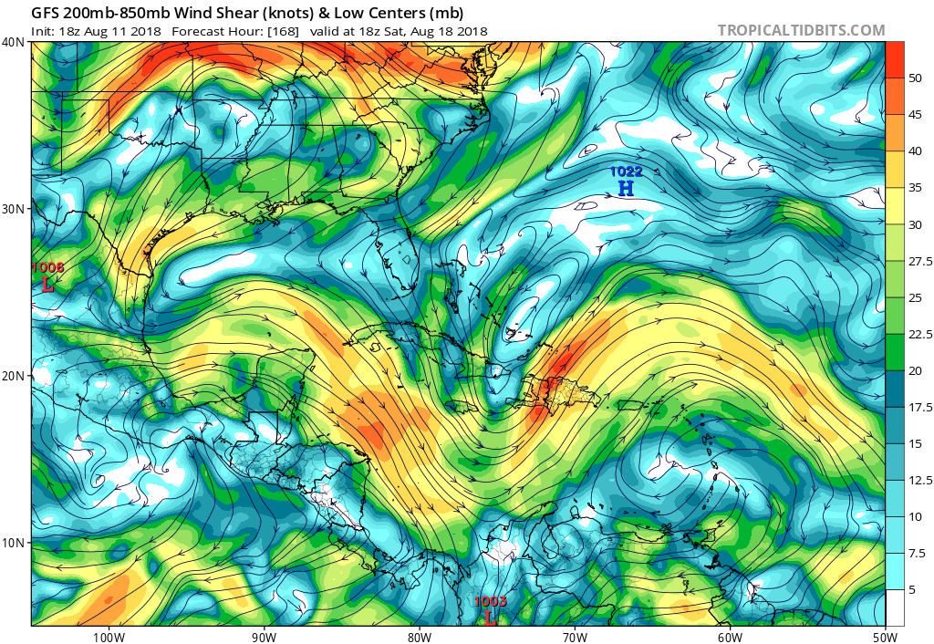
2 likes
-
gatorcane
- S2K Supporter
- Posts: 23499
- Age: 46
- Joined: Sun Mar 13, 2005 3:54 pm
- Location: Boca Raton, FL
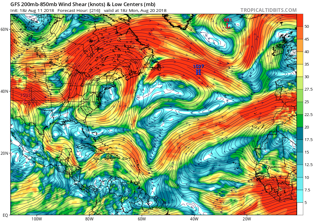
Re: 2018 Indicators: SST's / MSLP / Sal / Steering / Shear / Instability (Graphic updates at first post)
And here is the big picture as shown by the GFS 10 days from now. Look at the large anticyclones across the basin. One exiting the east coast of the US, another down in the southern Caribbean and another large one over the Eastern Atlantic. Definitely looking like upper-level conditions are becoming favorable finally which is expected as we head deeper into August:
2 likes
Re: 2018 Indicators: SST's / MSLP / Sal / Steering / Shear / Instability (Graphic updates at first post)
Ntxw wrote:Caribbean has averaged higher than normal years the past 30 days. So this is probably not the region to be looking. The Gulf is running below normal shear, subtropical atlantic also below normal. Those are probably areas to watch for down the road. Tropical Atlantic looks about normal shear.
https://twitter.com/philklotzbach/status/1027998679255449600
Interesting. I didn’t realize how significant of a correlation there is between Caribbean shear right now and how active the entire season for the entire basin will be overall. This sure makes me think that the quiet Eurosip forecasts (high SLP in MDR, Caribbean, Bahamas, FL, and GOM) have a good chance to verify.
0 likes
Personal Forecast Disclaimer:
The posts in this forum are NOT official forecasts and should not be used as such. They are just the opinion of the poster and may or may not be backed by sound meteorological data. They are NOT endorsed by any professional institution or storm2k.org. For official information, please refer to the NHC and NWS products.
The posts in this forum are NOT official forecasts and should not be used as such. They are just the opinion of the poster and may or may not be backed by sound meteorological data. They are NOT endorsed by any professional institution or storm2k.org. For official information, please refer to the NHC and NWS products.
-
tolakram
- Admin

- Posts: 19165
- Age: 60
- Joined: Sun Aug 27, 2006 8:23 pm
- Location: Florence, KY (name is Mark)
Re: 2018 Indicators: SST's / MSLP / Sal / Steering / Shear / Instability (Graphic updates at first post)
Last year was a good example of seemingly bad conditions until suddenly it wasn't. Remember all the upper level lows last year?
2 likes
M a r k
- - - - -
Join us in chat: Storm2K Chatroom Invite. Android and IOS apps also available.
The posts in this forum are NOT official forecasts and should not be used as such. Posts are NOT endorsed by any professional institution or STORM2K.org. For official information and forecasts, please refer to NHC and NWS products.
Re: 2018 Indicators: SST's / MSLP / Sal / Steering / Shear / Instability (Graphic updates at first post)
tolakram wrote:Last year was a good example of seemingly bad conditions until suddenly it wasn't. Remember all the upper level lows last year?
Keep in mind that last year started off as heading toward El Niño before it surprisingly made an unexpected about face toward a much more favorable for tropical La Niña. I don’t see anywhere near a repeat because the subsurface equatorial Pacific is so much warmer. Also, the Eurosip forecast for ASO of 2018 has much higher SLPs vs what it showed in 2017. Furthermore, the Caribbean shear at this time last year was not as high even though it wasn’t low.
1 likes
Personal Forecast Disclaimer:
The posts in this forum are NOT official forecasts and should not be used as such. They are just the opinion of the poster and may or may not be backed by sound meteorological data. They are NOT endorsed by any professional institution or storm2k.org. For official information, please refer to the NHC and NWS products.
The posts in this forum are NOT official forecasts and should not be used as such. They are just the opinion of the poster and may or may not be backed by sound meteorological data. They are NOT endorsed by any professional institution or storm2k.org. For official information, please refer to the NHC and NWS products.
Who is online
Users browsing this forum: cycloneye, Google Adsense [Bot], KirbyDude25, NotSparta, TheAustinMan, tolakram and 93 guests